6.4 Intrusive Igneous Bodies
In most cases, a body of hot magma is less dense than the rock surrounding it, so it has a tendency to move very slowly up toward the surface. It does so in a few different ways, including filling and widening existing cracks, melting the surrounding rock (called country rock[1]), pushing the rock aside (where it is somewhat plastic), and breaking the rock. Where some of the country rock is broken off, it may fall into the magma, a process called stoping. The resulting fragments, illustrated in Figure 3.19, are known as xenoliths (Greek for “strange rocks”).
![Figure 3.19 Xenoliths of mafic rock in granite, Victoria, B.C. The fragments of dark rock have been broken off and incorporated into the light-coloured granite. [SE]](https://psu.pb.unizin.org/app/uploads/sites/110/2018/07/xenoliths2-300x205.jpg)
Some upward-moving magma reaches the surface, resulting in volcanic eruptions, but most cools within the crust. The resulting body of rock is known as a pluton. Plutons can have various different shapes and relationships to the surrounding country rock as shown in Figure 6.20.
![Figure 3.20 Depiction of some of the types of plutons. a: stocks (if they coalesce at depth then they might constitute a batholith), b: sill (a tabular body, in this case parallel to bedding), c: dyke (cross-cuts bedding), d: laccolith (a sill that has pushed up the overlying rock layers), e: pipe (a cylindrical conduit feeding a volcano). The two features labelled f could be pipes or dykes, but from this perspective it’s not possible to determine if they are cylindrical or tabular. [SE drawing]](https://psu.pb.unizin.org/app/uploads/sites/110/2018/07/igneous-intrusives-4-e1442609875380.png)
Large irregular-shaped plutons are called either stocks or batholiths. The distinction between the two is made on the basis of the area that is exposed at the surface: if the body has an exposed surface area greater than 100 km2, then it’s a batholith; smaller than 100 km2 and it’s a stock. Batholiths are typically formed only when a number of stocks coalesce beneath the surface to create one large body. One of the largest batholiths in the world is the Coast Range Plutonic Complex, which extends all the way from the Vancouver region to southeastern Alaska (Figure 6.21). More accurately, it’s many batholiths.
Tabular (sheet-like) plutons are distinguished on the basis of whether or not they are concordant with (parallel to) existing layering (e.g., sedimentary bedding or metamorphic foliation) in the country rock. A sill is concordant with existing layering, and a dyke is discordant. If the country rock has no bedding or foliation, then any tabular body within it is a dyke. Note that the sill-versus-dyke designation is not determined simply by the orientation of the feature. A dyke can be horizontal and a sill can be vertical (if the bedding is vertical). A large dyke can be seen in Figure 6.21.
A laccolith is a sill-like body that has expanded upward by deforming the overlying rock.
Finally, a pipe is a cylindrical body (with a circular, ellipitical, or even irregular cross-section) that served as a conduit for the movement of magma from one location to another. Most known pipes fed volcanoes, although pipes can also connect plutons. It is also possible for a dyke to feed a volcano.
![Figure 3.21 The Stawamus Chief, part of the Coast Range Plutonic Complex, near to Squamish, B.C. The cliff is about 600 m high. Most of the dark stripes are a result of algae and lichen growth where the surface is frequently wet, but there is a large (about 10 m across) vertical dyke that extends from bottom to top. [SE photo]](https://psu.pb.unizin.org/app/uploads/sites/110/2018/07/stawamus-chief2-300x247.jpg)
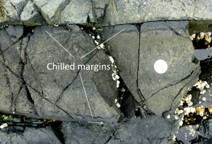
As discussed already, plutons can interact with the rocks into which they are intruded, sometimes leading to partial melting of the country rock or to stoping and formation of xenoliths. And, as we’ll see in Chapter 9, the heat of a body of magma can lead to metamorphism of the country rock. The country rock can also have an effect on the magma within a pluton. The most obvious such effect is the formation of a chilled margin along the edges of the pluton, where it came in contact with country rock that was significantly colder than the magma. Within the chilled margin, the magma cooled more quickly than in the centre of the dyke, so the texture is finer and the colour may be different. An example is shown in Figure 6.22.

Exercises
Exercise 6.7 Pluton Problems
The diagram here is a cross-section through part of the crust showing a variety of intrusive igneous rocks. Except for the granite (a), all of these rocks are mafic in composition. Indicate whether each of the plutons labelled a to e on the diagram below is a dyke, a sill, a stock, or a batholith.
| a | b | c | d | e |
- “Country rock” is not necessarily music to a geologist’s ears. The term refers to the original “rock of the country” or region, and hence the rock into which the magma intruded to form a pluton. ↵


