
9.1 Paths to an Expedition on JOIDES Resolution
We’d like to share how scientists take an idea and turn it into a research expedition at sea. As an example, we outline the process and timeline for those who sought to lead a mission on JOIDES Resolution during the International Ocean Discovery Program (IODP). Although IODP concluded in 2024, this snapshot offers a fascinating look at the steps involved in becoming an expedition leader.
Exercise: What if…?
Imagine you are going out to do field work and data collection at sea.
a) What would you need to know previous to starting a research project?
b) What would you need to know about the JOIDES Resolution?
c) What do you think you would need to include in a proposal for your research project?
While on an expedition, you are out on the ocean isolated from society focused on doing good science everyday for two months; but, it is only one piece of the research endeavor, and not the only exciting part. To be more specific, the expedition is two months of a 10+ year process.
What happens during all that time?
Any scientist that wanted to use the vessel for field research had to find a few different collaborators to draft up a proposal (sometimes two different proposals: a preliminary, and a full proposal) and prove that the research they were looking to do was both novel and multi-disciplinary. They also had to provide data (from previous expeditions or data they collected themselves more recently) to defend why that proposal had to be done specifically on JOIDES Resolution and not some other mission-specific platform. In just this beginning step of preparing and submitting the proposal, this step would already take several years.
Once past the proposal submission stage, it then had to be reviewed! During review, the process aimed to determine answers to the following questions from the proposal:
1. When can the ship be scheduled for use for the new cruise among the already scheduled expeditions?
2. What does the scientific party need on the ship to collect the data (ex: specific laboratory tools)?
3. What environmental concerns have to be addressed before the ship goes on the expedition in the proposed area?
4. Where can the ship dock pre- and post-expedition that coincides with other expeditions and fits the desired drilling area?
5. Who would be working with the science team outside of the collaborators that submitted the proposal?
Each of these questions would be discussed and reviewed by different advisory boards, that then informed the viability of the expedition the initial group of scientists envisioned.
Why are these questions important?
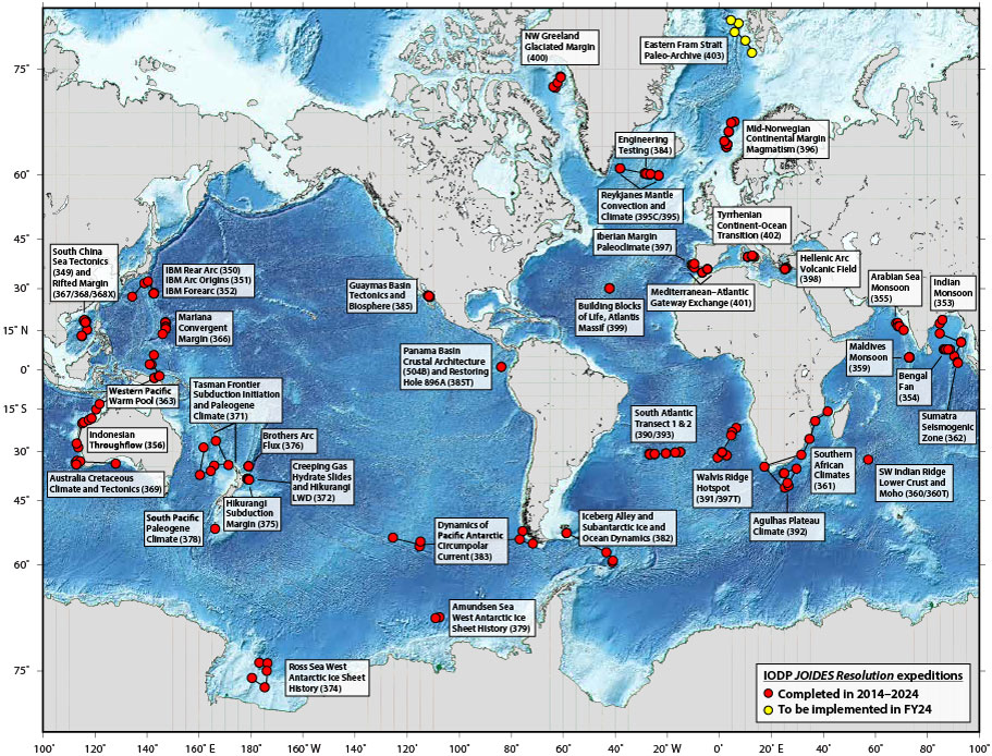
On average, JOIDES Resolution sailed three expeditions a year, sometimes more, all around the world. Finding where to include a new expedition was important to the continuation of scientific discoveries and to avoid slowing down the current scientific efforts of other expeditions. In addition, the weather patterns of the areas that would be traversed during transit were extremely important to the safety of the crew, the ship, and success of the work.
For example, if you want the ship to dock in South Africa for a proposed expedition, but that year the ship is scheduled for expeditions in the Pacific Ocean, your expedition would have to wait until there were other expeditions that would be sampling in the Atlantic Ocean. This was to prevent long transit times where the crew would be idle. You can see from the map below, all the expeditions completed in 2018 were grouped by their port in and around Australia and New Zealand.
One way to obtain data about the ideal drilling location and drilling sites was to start with a seismic survey. A seismic survey is a method of exploration that uses sound waves to create images of the Earth’s subsurface. The information from the survey assists scientists in visualizing layers, materials, and geological features, and making sure that scientists avoid proposing to drill in areas that contain potential oil and gas reservoirs. Other ships besides JOIDES Resolution would be commissioned to complete the marine seismic survey prior to any scheduled IODP expedition and prior to the full proposal review. For instance, the seismic survey for IODP Expedition 390/393 was conducted on R/V Marcus G Langseth.
View this video to learn more about how R/V Marcus G Langseth carries out a seismic survey and other research at sea.
Exercise: Questions about R/V Marcus G Langseth
Take a look again at the video above and answer the following questions:
a) How deep into the seafloor is the crew of R/V Marcus G Langseth able to see?
b) What equipment is used to obtain the seismic data?
c) How much data is collected each time the sound source is used?

This knowledge is then used to inform the JOIDES Resolution Science Operator (JRSO) team and the ship operator to determine what kind of drilling to expect and to prepare for when on the expedition.
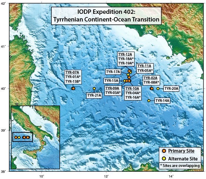
In addition to collecting seafloor data, knowing possible effects on the environment was part of any approval of an expedition. The environmental review board would take a look at the proposed drilling site locations, and how those sites fit into the overall area. They would then determine what sites are acceptable for primary sites, what sites can act as alternatives, and what sites are not approved due to concerning circumstances. For example, Expedition 402 had a site rejected as a primary and alternative site because it was found to be in close proximity to an internet cable, otherwise called submarine cables. It was deemed too much of a risk to have the ship drilling near an area that could mistakenly cut the internet to an entire city or country!
Finding the team
It is not over yet because even when one has collected seismic data, determined primary and alternative drilling sites, had the proposal reviewed and accepted, one still has to find the scientists that will sail on board JOIDES Resolution. Graduate students, post-doctoral researchers, and full-time scientists may apply to sail for a specific expedition years before the expedition even has a tentative sailing date, so the composition of scientists can inevitably change in the years leading up to the actual departure. The final group of scientists that sail on an expedition from member countries of IODP, from different career stages, different ages, and genders.
Point of View of a co-chief scientist
Behind an Ocean Drilling Proposal: The Path of Dr. Jason Sylvan, IODP Expedition 390 Co-chief scientist
“It was SO exciting to get the proposal accepted, I had started working on it as a postdoc and it was accepted when I was an Assistant Professor, so I had worked on it with my colleagues for several years at that point. I had no idea I would be selected as co-chief scientist at that point, so it was excitement that I would be able to get the samples and answer the scientific questions I had been working towards
“I am genuinely interested in how the world works, and in particular, in what microbial life exists at and

below the seafloor and what it is doing there. My particular expertise is in microorganisms that live in the volcanic rocks that are created by plate tectonics and underlie sediments throughout the oceans (basically, the seafloor aquifer). The only way to access this environment below the seafloor is by drilling, so the JOIDES Resolution (and also D/V Chikyu) are the most obvious choices for answering my questions about life in those environments.
“There was a seismic survey prior to our expedition that I was not part of but it was specifically a site survey cruise with it’s own science objectives that would also provide the seismic data we needed for our proposal. To drill the seafloor, one must know what they are drilling into. Partly for safety (IODP did not drill into hydrocarbon reservoirs or other potential hazards) and partly to confirm that the subseafloor targets one wants to target for sampling with the JOIDES Resolution are actually there, as best as seismic surveys can inform us. We also had the data from Leg 3 to help guide hypotheses. For example, from Leg 3, we knew there was sulfate in the deepest sediment samples, which tells us a little about what microbiology could be present, and also about the types of rocks and sediments previously recovered.
“This expedition was originally planned as a transect that mirrored Deep Sea Drilling Project Leg 3 (which sampled a transect along the same lines as ours, but 50 years prior. That expedition confirmed the theory of plate tectonics). While Leg 3 was amazing, it used older technology and revisiting that line could enable some really exciting science. So the general plan was the same, but our original proposal had equal weight to hard rock geology/petrology, microbiology and paleoceanography. We asked for one expedition. Through the review process that goes into these projects, we were told to prioritize the geology/petrology and microbiology over the paleoceanography objectives and also awarded two expeditions (390 and 393) to complete the work, which was quite ambitious (even for two expeditions, it turns out).”
A summary of the total process
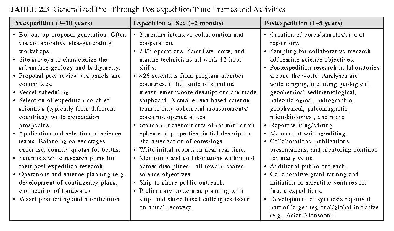
Exercise: The Expedition-From Planning to Discovery
The table below shows the timeline of tasks that take place before, during, and after an expedition. After reviewing the table, think about the types of teams and systems needed to make an expedition possible. Then answer the questions below:
a) If scientists outside of the ship operations are responsible for developing the proposal, conducting the research, and publishing the results, what types of people are needed to handle ship operations, scheduling, and other non-research duties?
b) What core skills should team members have to help ensure the expedition runs smoothly and successfully?
Descriptive text for Table 2.3
TABLE 2.3 Generalized Pre- Through Postexpedition Time Frames and Activities
Preexpedition (3-10 years)
- Bottom-up proposal generation. Often via collaborative idea-generating workshops.
- Site surveys to characterize the subsurface geology and bathymetry.
- Proposal peer review via panels and committees.
- Vessel scheduling.
- Selection of expedition co-chief scientists (typically from different countries); write expectation prospectus.
- Application and selection of science teams. Balancing career stages, expertise, country quotas for berths.
- Scientists write research plans for their post-expedition research.
- Operations and science planning (e.g., development of contingency plans, engineering of hardware).
- Vessel positioning and mobilization.
Expedition at Sea (~2 months)
- 2 months intensive collaboration and cooperation.
- 24/7 operations. Scientists, crew, and marine technicians all work 12-hour shifts.
- ~26 scientists from program member countries, if full suite of standard measurements/core descriptions are made shipboard. A smaller sea-based science team if only ephemeral measurements/cores not opened at sea.
- Standard measurements of (at minimum) ephemeral properties; initial description, characterization of cores/logs.
- Write initial reports in near real time.
- Mentoring and collaborations within and across disciplines—all toward shared science objectives.
- Ship-to-shore public outreach.
- Preliminary postcruise planning with ship- and shore-based colleagues based on actual recovery.
Postexpedition (1-5 years)
- Curation of cores/samples/data at repository.
- Sampling for collaborative research addressing science objectives.
- Postexpedition research in laboratories around the world. Analyses are wide ranging, including geological, geochemical sedimentological, paleontological, petrographic, geophysical, paleomagnetic, microbiological, and more.
- Report writing/editing.
- Manuscript writing/editing.
- Collaborations, publications, presentations, and mentoring continue for many years.
- Additional public outreach.
- Collaborative grant writing and initiation of scientific ventures for future expeditions.
- Development of synthesis reports if part of larger regional/global initiative (e.g., Asian Monsoon).
Things Don’t Always Go As Planned
All of the expedition details can be worked out ahead of time, but there are some things that just can’t be planned for ahead of time. For example, the phrase “the journey is half the fun” was anything but fun for geochemist Jeff Ryan before his first time sailing on JOIDES Resolution.
In 2014, Jeff Ryan packed his bags and boarded his flight to Yokohama, Japan, to join JOIDES Resolution for IODP Expedition 352. Jeff arrived in Japan just fine. His luggage – well, that’s another story…
Although scientists and the crew hope that once the ship departs port, it is all smooth sailing for their two months at sea. However, despite all the advanced planning, sometimes, decisions and approvals come in later than expected.
SciOD Spotlight – Waiting in India’s EEZ, with Priyank Jaiswal
Geophysicist Priyank Jaiswal describes his first time sailing on JOIDES Resolution for Expedition 353 and the complexities of getting permission to drill in India’s Exclusive Economic Zone. Everyone knew the permission would come through – they were just hoping it would happen before arriving at the drill site. What did everyone do to keep busy on board while waiting for that permission? Take a listen.
