
Chapter 2 – Wildfire
Lindsey Anderson, Landscape Architecture, Penn State College of Arts and Architecture
For my second Capstone I decided to investigate a small town in Australia called Guyra. This town has a population of around 2,000 people and they are becoming especially affected by droughts happening in Australia. They are located next to a freshwater lagoon that is becoming dryer and dryer. Besides the town’s low precipitation environment, they are especially susceptible to an issue such as this one because of how foreign they are to financial hardship. Australia has experienced substantial growth for more than the past generation, so the current trend of environmental issues is hitting them hard. The drought is caused by the increased air temperature which is causing issues like droughts and wildfires. Although many towns in Australia are struggling due to the new lack of rainfall, this town in particular has heard that their lagoon’s water could run out in just 400 days. Like many issues we will cover in this class there are short term solutions, but the only solutions that are going to make any difference are going to be reducing our greenhouse gas production. The town’s mayor is currently frantically trying to drill, create dams, build pipelines, and truck in freshwater. The main issue stemming from these efforts is that there isn’t a lot of water in other parts of Australia either, so trying to redistribute will not work for long. In addition, these ideas help people now, but don’t even begin to affect the root of the situation, which is global warming. So, these short-term band-aids are only helping the lack of water, not the issues stemming from the drought such as wildfires. The only true solution to this issue would be to cut down on greenhouse gas emissions all across the globe.
Sources
Barrett, J. (2019, September 27). Drought-hit Australian towns prepare for ‘unimaginable’ water crisis. Reuters. https://www.reuters.com/article/us-australia-drought-water/drought-hit-australian-towns-prepare-for-unimaginable-water-crisis-idUSKBN1WC2EP
Wildfires in Shingletown, California
Lucas A. Barnak
California has been experiencing an unprecedented number of wildfires in recent years, so I have decided to dive deep into one individual community in California, called Shingletown.
The threats of these wildfires in such a small town with a population of just 2,246 people and a median income of $45,609 are if their community is ravaged by a gruesome fire, it may take years for them to financially get back on their feet and rebuild their community. These fires may also create or elongate existing respiratory illnesses for all members of the community.
Shingletown is severely vulnerable to these fires because there has been a recent drought in the area, which in turn leads to an increase in dead plants and trees that are inherently very prone to catching fire. Incorporate these factors with climate change increasing heat and with the strong winds that the community experiences, and it will leave the town to be a likely candidate for severe forest fires.
The forecasted impacts on the Shingletown community consist of the destruction of thousands of homes, businesses, and public amenities such as parks. Along with the destruction of these pieces of property comes the air pollution in the community, where the median age of occupants is 60, leaving them to be prime targets for respiratory illnesses. The polluted air will also exacerbate any preexisting conditions of the citizens further.
The solutions to these threats consist of the community working together in an attempt to prevent any of these situations from becoming a part of their future. In fact, the community created and published a Fire Safe Program, which stresses that the most efficient way to prevent these wildfires is to educate yourself on the ways they start. Their first step as a community is to lessen the amount of vegetation waste produced, and to dispose of it in a proper manner. This vegetation consists of dry leaves from yards, old clippings of grass, etc. The community established a recycling system specifically for these materials and plans to dispose of them in a manner which will mitigate the chance of them causing wildfires.
Sources
Delgado, A. L., & Patar, D. (2019, September 21). Communities search for ways to live with growing fire threat. ABC News. https://abcnews.go.com/Technology/wireStory/communities-search-ways-live-growing-fire-threat-65770406
A Fire Safety Community. (n.d.). In Case Studies: Shingletown California. EERI.org. https://mitigation.eeri.org/files/resources-for-success/00080.pdf
Joseph, S., & Schmieding, S. (2019, May 24). OUR FUTURE AFTER THE FIRE: WHAT PLACES ARE AT RISK? Action News Now. https://www.actionnewsnow.com/content/after-the-fire-content/After-the-Fire-What-places-are-at-risk–510389761.html
Kastanis, A. (2019, April 11). These California communities could be the next Paradise. Is yours one of them? The Sacramento Bee.
Shingletown, CA. (n.d.). Data USA. https://datausa.io/profile/geo/shingletown-ca
Alyssa Butters, Biobehavioral Health, College of Health and Human Development
The topic and community that I have chosen is fires in Malibu, California. Wildfires are not a new phenomenon in California, as California’s fire record goes all the way back to 1932. In 2020 alone, more than 2 million acres burned from fires in California (Pierre-louis & Schwartz, 2020). This was a new record, and not one that anyone wanted to break.
Malibu, California is located in what is called the Wildland Urban Interface, where there is a combination of infrastructures with forests, fields, and other wildlife (Vandermeulen, 2020). The increase in the number of wildfires is due to a number of factors, including high temperatures and high winds. Climate change is a major contributor here, as the warmer temperatures have caused the vegetation to become drier, making it very flammable, the perfect storm for a wildfire to rage (Pierre-louis & Schwartz, 2020). Malibu has already experienced multiple wildfires, with the Woolsey wildfire in 2019 alone causing more than $1.6 billion in damage to homes (Stiles & Schleuss, 2018). Not only do fires cause damage to infrastructures as well as loss of life, but the smoke from these fires can reach communities that the flames don’t, causing severe air quality problems.
It is hard to come up with solutions on how to stop wildfires, but there are ways that the city of Malibu can help to prevent a small wildfire from turning into a big and out of control wildfire. One solution is to build buildings using fire-resistant materials. That way, the building will not act as fuel for the fire. These materials include things such as bricks, masonry, and cement (Vandermeulen, 2020). Another solution is to administer controlled burns in the land surrounding Malibu. Controlled burns are highly controlled and purposeful fires that help to prevent large scale wildfires from occurring by reducing the amount of flammable vegetation (USDA Forest Service, 2021). If there are not thousands of acres of untreated and lively vegetation for the fire to rampage, then this lessens the likelihood that a wildfire could become out of control quickly.
Sources
Pierre-louis, K., & Schwartz, J. (2020, December 3). Why does California have so Many Wildfires? New York Times. https://www.nytimes.com/article/why-does-california-have-wildfires.html?auth=login-google.
Stiles, M., & Schleuss, J. (2018, December 3). Woolsey fire likely worst ever to hit Malibu, with home Losses Topping $1.6 billion. LA Times. https://www.latimes.com/projects/la-me-malibu-woolsey-destruction-map/
USDA Forest Service. (2021). Controlled Burning. https://www.fs.usda.gov/detail/dbnf/home/?cid=stelprdb5281464
Vandermeulen, J. (2020). Fire Safety. Malibu City. https://www.malibucity.org/952/FireSafety#:~:text=Thousands%20of%20homes%20in%20Malibu,%2C%20fields%2C%20and%20other%20wildlands.&text=Embers%20are%20one%20of%20the,your%20home%20during%20a%20wildfire.
Luke Cantrel, Mechanical Engineering, College of Engineering
The city of Sydney, Australia has had a recent dramatic surge in the severity and frequency of wildfires. According to the New York Times, the 2019 fire season was the most severe and long lasting in the city’s recorded history (Cave, 2019). In addition to the physical damage of these fires, the gasses and pollutants that are released into the atmosphere are severely hazardous to the citizen’s health. In December of 2019, the city recorded its worst day in air quality, where pollutants reached an incredibly hazardous level for 24 hours (Popovich, 2020). At one point, levels of the most harmful type of air pollutant, PM2.5, were 22 times greater than the standard safety value (Cave, 2019).
One of the major reasons Sydney is so vulnerable to wildfires is because of the nation’s conservative government, and their reluctance to acknowledge climate change and regulate fossil fuel emissions. According to the city’s residents, the government is favoring the economic benefits of its fossil fuel industries over the health and safety of its largest city (Cave, 2019). As a result, fossil fuel emissions continue to be unregulated, which in turn leads to rising heat levels and drier vegetation that provide better conditions for deadly fires. Another major factor that contributes to Sydney’s fire vulnerability is the fact that the city lies on a wildland urban interface. The city’s close neighbor, a fire-prone forest environment, puts it at great risk of unplanned fires that spread to the city and destroy buildings and other assets (Price & Bradstock, 2011).
If these wildfires are not addressed appropriately, the citizen’s health and the city’s resources will pay the price. According to local officials, hospital visits for breathing problems, especially asthma, rose significantly during periods of wildfires, and stores quickly ran out of masks, air purifiers, and other equipment used to protect people from the harmful air (Popovich, 2020). Additionally, many of Sydney’s firefighters have warned the city that it is already short on supplies and the necessary resources for battling these intense fires, and that they will become desperately in need as these fires begin to grow in strength and frequency (Cave, 2019). Thus, these continued fires put Sydney at an extreme risk of severe health issues and resource shortages. In terms of proposed solutions, a lot of pressure falls on the government to adapt its policies in the face of climate change. Climate protests in Sydney are rising, with people calling on the government to regulate emissions with the hope of lowering regional warming (Cave, 2019). Expanded use of planned burning is also a proposed solution to the wild fires. Research shows that reduction in unplanned fires by a certain factor would require an increase in planned fires by about two to four times the desired reduction factor (Price & Bradstock, 2011). This proposed solution carries with it additional challenges in executing planned fires to that extent, but it is still one of the best options Sydney has, in addition to reformed government policy, for combating these fires.
Sources
Cave, D. (2019, December 6). Australia Burns Again, and Now Its Biggest City Is Choking. The New York Times. www.nytimes.com/2019/12/06/world/australia/sydney-fires.html?searchResultPosition=3.
Popovich, N. (2020, January 3). Millions of Australians Are Choking on Smoke From Wildfires. The New York Times. www.nytimes.com/interactive/2020/01/03/climate/australia-fires-air.html?searchResultPosition=8.
Price, O. F., & Bradstock, R. A. (2011, February 14). Quantifying the Influence of Fuel Age and Weather on the Annual Extent of Unplanned Fires in the Sydney Region of Australia. International Journal of Wildland Fire 20(1), 142-151. https://doi.org/10.1071/WF10016.
Nicolette Cusate, Agricultural and Extension Education, Penn State Behrend
Blue River, Oregon is a small unincorporated town approximately three hours south of Portland, Oregon with a population of 814 people. Blue River, OR is also located in Willamette National Forest and is protected by the Oregon Department of Forestry. In early September 2020, a wildfire started in Lane County near Blue River. The fire was named “The Holiday Farm Fire” and was part of the 2020 Oregon Wildfire season. The cause for the tragic event that destroyed over 350 structures is unknown, but is said to have spread due to high winds in combination with the dry season. It is still active into April of 2021, but recent reports say that the Holiday Farm Fire is over 90% contained.
Not only is Blue River vulnerable to wildfires for a variety of reasons, but this has led to an increase of vulnerability concerning surface runoff. Since so much of the forest has burnt down, the organic layer of humus on the forest floor has been destroyed, meaning that Blue River is more susceptible to surface runoff and water flowing into areas that it did not flow before. Also, this decrease in humus and increase in runoff will affect the carbon cycle in the area by depositing carbon into the waterways. As for the forecasted impacts of the Holiday Farm Fire, Blue River is located in the McKenzie River watershed, which has been greatly affected by the fire. One major concern to consider is that the wreckage, ash, and debris from the fire will eventually flow into the watershed, potentially harming their drinking water. Another consideration is the decrease in agriculture and forestry, in which it will take years to grow back. In addition, the costs associated with clearing trees and damaged homes can significantly impact the community’s economic status. Finally, a smaller impact, but still one worth noting, is that these changes in the watershed could potentially impact the organisms that inhabit it.
Solutions to ending the Holiday Farm Fire are still uncertain, but many are underway. A possible solution is fire breaking, where areas are cleared of vegetation to reduce the spread of wildfires. Residents are working together to clear wreckage, and other organizations are providing victims with temporary housing. Although areas that have a hot and dry season are not always safe from wildfires, there are ways to prevent humans from starting them. Being careful with campfires, grills, and fireworks are good ways to prevent starting a fire that could easily get out of hand. It is also worthwhile to have a hose or fire extinguisher nearby just in case. In closing, Blue River, Oregon is far from a full recovery from the Holiday Farm Fire and the long term impacts will need attention, but this small community is coming together to make restoration possible.
Sources
Duvernay, A. (2020, November 20). In the Ashes of the Blue River, Returned Residents Dream of Rebuilding. The Register-Guard. https://www.registerguard.com/story/news/2020/11/21/ashes-blue-river-returned-residents-dream-rebuilding-after-holiday-farm-fire/6026626002/
Holiday Farm Fire Information. (n.d.). Singleton Law Firm. https://slffirm.com/holiday-farm-fire/
Nelson, A. (2020, October 3). Assessing Fire Impacts on McKenzie River Watershed. The Register-Guard. https://www.registerguard.com/story/news/2020/10/03/oregons-mckenzie-river-watershed-shows-impacts-intense-wildfire/5878809002/
Wildfire desolates small community in east Washington State
Alexandra Diaz, Microbiology, Eberly College of Science Penn State University
Located in Whitman county of east Washington state, the town of Malden has a relatively small population of around 200 (CBS, 2020). This small, rural community found themselves in a state of emergency in early September as a wildfire blew through the community, destroying the majority of the buildings and other infrastructure (Katkov & Chappell, 2020). In a normal year, the town of Malden’s summer climate is warm and dry and often referred to as a warm-summer Mediterranean climate. However, this early September, the area was particularly warm and dry (“Malden, Washington…,” 2020). With the combined effect of the post hurricane season winds from the coast, the perfect conditions for a devastating fire were set. Several fires were started across the pacific northwest. The particular fire that hit the town of Malden had been started by winds of around 45mph (Katkov & Chappell, 2020). This created a fast moving blaze that tore through the surrounding forests before hitting the town.
The town of Malden is small and relatively isolated from the rest of the state. This meant that when the fire was fast approaching, the residents were forced to evacuate themselves. According to reports, the evacuation of the town was successful and everyone was able to leave in time (Katkov & Chappell, 2020). This was not a small feat as many of the townspeople live relatively far away from each other, making it difficult to spread the word of evacuation.
While the evacuation was successful in protecting the residents, many lost their homes to the fire. The Whitman County sheriff’s office reported that 80% of the buildings in Malden were destroyed . The buildings decimated, municipal buildings like the fire station, city hall, library and post office, were lost in addition to the majority of the private residences (Katkov & Chappell, 2020). These damages will certainly cost millions of dollars and continue to weigh heavily on the townspeople as they venture to rebuild their community in the time to come.
Wildfires are common in this region of the country, in these conditions, at this time of year, so it is difficult to determine an exact solution or any measure of future prevention. However, some solutions include forest management, controlled burns, removing brush, and not developing in high risk areas. The devastating impact the wildfire had on such a small town should not be written off. The town of Malden will take years to recover and rebuild after this event as many of its residents’ lives have been completely changed by the tragedy.
Sources
CBS News. (2020). Wildfire ravages tiny Malden, Washington, destroying post office, city hall, firestation, most homes. https://www.cbsnews.com/news/malden-washington-fire-destroys-town-post-office-city-hall-fire-station-homes/
Katkov, M., & Chappell, B. (2020). Fast-Moving wildfire destroys 80% small town in Eastern Washington State. NPR. https://www.npr.org/2020/09/08/910578980/fast moving-wildfire-destroys-80-of-small-town-in-eastern-washington-state
Malden, Washington Climate Classification. (2020). WeatherBase. https://www.weatherbase.com/weather/weather-summary.php3?s=81754&cityname=Malden%2C+Washington%2C+United+Stat es+of+America&units=
C. M. Erikson, Earth Sciences, College of Earth and Mineral Sciences
At the base of Yucaipa Ridge of the San Bernardino Mountains, the town of Yucaipa faces a dual threat of the combination of fire and debris flows. Most recently, these dangers displayed their prominence during the El Dorado Fire which scorched the slopes of the ridge and encroached on properties at the foot of the mountain. At a small camp in Oak Glenn, directly at the base of a canyon of Yucaipa Ridge, two residents shared how although they were thankful the fire had run around them rather than passing through the camp, they were now concerned by possible debris flows which had proved to be damaging in the past (Personal Communication).
Dealing with both hazards will become increasingly common for the camp and surrounding area, as warming temperatures in the already semi-arid landscape are expected to increase the frequency of fires (Mann et al., 2016). As the vegetation is burned during such an event, loose sediment is able to travel into headwater channels in the mountains where it is stored until a large precipitation event occurs and scours out the accumulation (DiBiase & Lamb, 2019). Because of this, large quantities of sediment and debris can be entrained and sometimes catastrophically cascade into communities below, as was the case on the north side of Yucaipa Ridge in 1999, where debris killed a person and caused property damage (Morton & Hauser, 2001).
The numerous small developments along the ridge are often built on the alluvial fan of past debris flows, which suggests there is a strong likelihood future flows will be an issue. Even if communities are spared of this, many are close enough to the chaparral of the mountains that fires can reach them as well as they burn across the mountains. Relocation is probably the only effective way to avert disaster, since many strategies being employed in nearby areas would not be as useful in such proximity to the mountains. Some areas have built dams at debris basins to retain sediment, but the stream network directly at the edge of the ridge would lack development and require many such dams because of this. Practices which prevent human-incited fires and planned appropriate responses including evacuations are the most effective present form of mitigation (Christensen & Wigglesworth, 2020).
Sources
Christensen, K., & Wigglesworth, A. (2020, September 5). Fast-moving fire threatening communities in Yucaipa; evacuations underway. Los Angeles Times. https://www.latimes.com/california/story/2020-09-05/fast-moving-fire-threatening communities-in-yucaipa-evacuations-underway
DiBiase, R. A., & Lamb, M. P. (2019). Dry sediment loading of headwater channels fuels post wildfire debris flows in bedrock landscapes. Geology, 48(2), 189–193. https://doi.org/10.1130/g46847.1
Mann, M. L., Batllori, E., Moritz, M. A., Waller, E. K., Berck, P., Flint, A. L., . . . Dolfi, E. (2016). Incorporating Anthropogenic Influences into Fire Probability Models: Effects of Human Activity and Climate Change on Fire Activity in California. Plos One, 11(4). doi:10.1371/journal.pone.0153589
Morton, D. M. and Hauser, R. M., (2001). A Debris Avalanche at Forest Falls, San Bernardino County, California, July 11, 1999: U.S. Geological Survey Open-File Report 01-146, 67 pp., https://pubs.usgs.gov/of/2001/0146/
Camp Fire: Paradise, California
Robert Estephan, Political Science, World Campus
The small town of Paradise was decimated by a fire in the beginning of November 2018. This fire was the result of many foreseen events; however, it was a perfect storm that created such an efficient and horrific event. This fire killed 88 people and destroyed 18,000 buildings and homes and cost over 15 billion dollars in restoration. Many of the people that died were senior citizens. One year later only 11 homes were rebuilt.
One of the main reasons for such a high death toll was there were too many people without a good evacuation route. There is only one road with one lane in each direction. The potential for this disaster was predicted with some accuracy by The California Department of Forestry and Fire Protection in 2005. The State of California is responsible for deforestation to help prevent the spread of fire, and this was neglected due to budget constraints. As a result, the fire spread unimpeded. They have since recommended using the only road as a single direction two lane road out of town for future evacuations. This would essentially double the evacuation efficiency.
A damp spring led to heavy grass growth. This was followed by a drought and very warm temperatures. The average rainfall used to be seven inches per season. In 2018, it was only .88 inches. Climate change has shortened the rainy season and led to an increase in temperature. This turned the vegetation into fuel. This, coupled with the seasonal Santa Ana winds that can reach 60 miles an hour, would fan out the smallest of flames. The wind travels downhill being compressed, which warms it and dries it out. This process known as evapotranspiration is what dried the plants out, turning them into kindling material. The fire was started by the electric provider PNGE who had a faulty wire. PNGE later filed for bankruptcy due to the liability of their neglect. The dried-out vegetation and the high winds made it spread quickly and easily. This then spread to homes and businesses which became part of the fuel and devastation.
The town of Paradise has executed a fire prevention code that is intended to limit the spreading of a future fire and allow for better evacuation. They have created rules, such as grass must be cut below three inches, brush must be removed from yard, debris cleaned from roof, firewood and propane tanks stored away from the structure, and other items to limit the spread of a fire onto the building.
There is very little doubt that there will be future fires in Paradise, California. With fewer people living there, a better evacuation route and an early warning system, hopefully future lives will be saved.
Sources
Wright, P. (November 11, 2018). At Least 23 Dead in Wildfire That Destroyed Northern California Town and Is Now the Most Destructive Fire in California History. The Weather Channel.
Reyes-Velarde, A. (January 11, 2019). California’s Camp fire was the costliest global disaster last year, insurance report shows. Los Angeles Times.
Curtis, C. (n.d.). Town of Paradise – Fire. Town of Paradise.
Robertson, A. (May 15, 2019). Investigators confirm that PG&E power lines started the deadly Camp Fire. The Verge.
Williams, S. (January 18, 2019). PG&E’s Bankruptcy Will Be Costlier Than You Realize. The Motley Fool.
Camp Fire devastates Paradise near Chico – businesses, church, numerous homes burn. (2018, November 8). San Francisco Chronicle.
Wildfires in Paradise, California
Mikhail Galperin, Business Administration, Penn State World Campus
Paradise, a town located in Butte County, CA, experienced a terrible wildfire on November 8th, 2018. Despite extensive preparations against wildfires — including evacuation plans and programs to reduce growth of brush and vegetation — the town was quickly engulfed in over 60 spot fires within a two-hour period, leaving citizens trapped in their cars and homes.
What started as a fire from a broken clamp on an electric utility transmission tower quickly spread as a result of several social and environmental conditions: 50 mile per hour winds, 200 days of minimal rain and snow, decades of no fires leading to vegetative overgrowth, seven miles of vegetative fuel separating Paradise from the source of the fire, overgrown evacuation routes, diseased pine trees, alert and communications systems with insufficient capacity, and residential non-compliance with vegetative growth reduction programs.
The impacts from the Camp Fire were enormous. In Paradise and other neighboring communities, there were a total of 85 casualties. Over 10,000 buildings were destroyed, contributing to property damage totaling over $16 billion. The utility responsible for the fire, PG&E, declared bankruptcy after pleading guilty to manslaughter charges. Even several years later, PG&E’s victim compensation trust is reportedly over $1 billion short of what is required to pay out claims.
As a result of this tragedy and others like it, steps are being taken to address the growing concern of wildfires. Hundreds of millions of dollars were budgeted for U.S. Forest Service programs to help manage the forests to prevent further fires. An estimated $38 million could be required to retrofit vulnerable homes in communities like Paradise to better withstand fires, on top of the costs behind maintaining clear evacuation routes and deforested areas meant to slow down fires. With recent wildfire seasons growing worse in intensity, there are no signs of wildfires like the Camp Fire going away. However, with thorough preparedness and proper evaluation of the contributing factors behind the Camp Fire, the hope is that California communities will not have to suffer the same fate as Paradise.
Sources
Kasler, D. (2021, January 29). PG&E settlement fund $1 billion short for California wildfire victims, trust’s leader warns. The Sacramento Bee. https://www.sacbee.com/news/california/fires/article248881899.html
Kasler, D., & Sabalow, R. (2021, February 8). Paradise was ‘well-prepared’ for deadly Camp Fire. But it wasn’t enough, new study finds. The Sacramento Bee. https://www.sacbee.com/news/california/fires/article249017825.html
Laura G
Fires are a serious and dangerous threat to begin with, and climate change is not helping slow down the prevalence and severity of the wildfires around the world. Climate change is creating more fires in the western United States and the wildfire season seems to be much longer and more extreme compared to previous years. A combination of winds, drought, high temperature, and low humidity makes the perfect conditions for a wildfire, which is exactly what happened to a small town in eastern Washington in the beginning of September of 2020 (Criscione, 2021). Malden, Washington is a town in Whitman county that has a very small population. The threat to the community is wildfires, which are what ended up demolishing the town. The community is vulnerable because it is in the range where wildfires are predicted to occur. These fires, fires due to the warming earth, are called “climate fires” (Criscione, 2021). Fortunately, there were no deaths that were caused by the fire, but the amount of infrastructure that was completely turned into ash was astonishing (Criscione, 2021). 121 homes were burned to the ground, and about 100 other properties were destroyed in the matter of a couple of hours (Criscione, 2021). Conditions in recent years make fires basically unstoppable. This makes the forecasted impacts on the community unpredictable, and besides evacuating the town, there is not really much else they can do when a fire creeps in. Fires are very serious, and without the right resources there may not be too many solutions to the threat of more wildfires occurring in the small town of Malden. Possible solutions to the threat of wildfires would be to make sure that grass and trees don’t get too dry (Criscione, 2021). Houses and other facilities in Walden can be rebuilt, but will never be the same town as it was before the unexpected wildfire that turned the town upside down.
Sources
Criscione, W. (2021, January 26). How a fire destroyed the town of Malden in a matter of hours. Inlander. https://www.inlander.com/spokane/how-a-fire-destroyed-the-town-of-malden-in-a-matter-of-hours/Content?oid=20284714
Pollution of Water Sources Due to Wildfires in Paradise, California
Eathan R. Gottshall
California is no stranger to wildfires due to its major fluctuations in precipitation rates and lack of humidity. All it takes is one stray match to devastate a whole town or city. Wildfires are expected to increase in frequency in areas of the US such as California and Oregon as precipitation continues to decrease in these regions and water reservoirs continue to deplete. The 2020 wildfire season was absolutely devastating in terms of longevity, quantity of simultaneous fires, and the major costs to life and property. These fires made thousands homeless, seeking refuge in shelters, and led to dismal air quality that will impact Californian citizen health for years to come. However, there is another major impact left behind by wildfires that is not immediately noticeable without deeper investigation, and that is water pollution. Wildfires can emit all kinds of toxic chemicals and substances into the atmosphere, and much of this material soon falls, finding its way into public and private water supplies, tainting them to the point where filtration and boiling may still be unable to filter the abundance of potentially dangerous substances. In a state that is already experiencing major water scarcity the idea of good water being completely contaminated could cause any number of cascading problems for communities, like the town of Paradise, California after Camp Fire in 2018. Many individuals in Paradise lost their homes and most of what they owned, leading them to camp next to the piles of their former belongings or seek refuge out-of-state or in a public shelter. Public officials informed locals to not drink or bathe with public water because it is likely too contaminated to purify in an easily accessible way, so many are forced to drink and bathe from nothing but water bottles. The economic cost to even a small town whose water system must undergo major repairs could cost hundreds of millions of dollars. Paradise alone paid 130-150 million dollars to repair their irrigation system and are still seeking funding to do so even more than two years after Camp Fire. These types of contamination are commonplace following wildfires, and some can last in a water supply for years before a proper filtration solution can be devised. In the future, with the constant rise in global temperatures and greater frequency of climate extremes continuing in California and areas like it, drought and wildfires will increase seasonally and cause yearly infrastructure damage. In order to combat future contamination, communities are working to update public water systems to flush completely and isolate burning neighborhoods while creating procedures to streamline testing and communication to residents following a major wildfire event. The 2021 season is forecasted to be extremely dry and hot, just as 2020 was, so hopefully officials have had enough time to address ways to prevent wildfires from happening and deal with the fallout of one effectively.
Sources
Becker, R. (2020, October 5). Unsafe to drink: Wildfires threaten rural towns with tainted water. Cal Matters. https://calmatters.org/environment/2020/10/california-wildfires-unsafe-drinking-water/
David Harvey
Located just south of Bozeman, Montana, the community of Big Sky is home to 2,308 people. Big Sky’s lush landscape, rich green lands, and excellent slopes provide a wonderful attraction for tourists, who comprise the vast majority of the local economy (Big Sky, Montana, 2021). On the edge of the Rocky Mountains, the area is rife with woodlands and evergreens that are susceptible to wildfires, which threaten livestock, people, wildlife, and habitat. Wildfires can range in size, from a few acres to tens of thousands of acres burning (French, 2020). Raging through large swaths of land, the beauty of Big Sky’s mountains and forests can be turned to an ugly burnt mess in a matter of hours. Thus, the incentive for a tourist to visit the area is destroyed with each wildfire, and the economy is burned with the priceless habitat in each destructive blaze. It is not just wildfires in Montana that can affect Big Sky. Clouds of smoke from large fires in California, Washington, and Oregon, can drift over the Big Sky region, lowering air quality and creating an impenetrable barrier between the sun and photo-synthesizers below (Puckett, 2020). Interestingly, some types of deer and elk benefit from wildfires, since wildfires clear the land and allow certain types of vegetation to grow that are favored by those fauna (Hillis, 2020). Unfortunately, other beasts do not experience such serendipity. white-tailed deer especially suffer, as they eat different plants than elk (Hillis, 2020). In Big Sky, bigger and nastier fires could have immediate effects (like the burning of homes and businesses) and longer-term effects, such as a shift in the relative amounts of deer, elk, and other animals, or even a shift in the flora of the region, which could be catastrophic to the local ecosystem. The answer to Big Sky’s forest fire problem is almost counterintuitive. By using controlled burns at strategically chosen times, the amount of smoke and the overall damage to the area over time can be minimized (Forest fire management…, n.d.), thereby maximizing the ability of Big Sky and its surroundings to attract visitors. Controlled burns would prevent out-of-control fires that wantonly destroy, and facilitate the healthy growth of flora and fauna in Big Sky’s mountains.
Sources
Forest fire management: A low cost solution: Natural climate solutions. (n.d.). Nature4Climate. https://nature4climate.org/science/n4c-pathways/forests/forest-fire-management/.
French, B. (2020, November 5). Wildland fire burning south of Big Sky. The Billings Gazette. https://billingsgazette.com/outdoors/wildland-fire-burning-south-of-big-sky/article_43d5e590-03f4-5ddf-aee2-0eeb4a53075a.html#:~:text=The%20Porcupine%20fire%20is%20about%20one%20mile % 20south,junction%20in%20Big%20Sky%20near%20the%20Porcupine%20Trailhead.
Hillis, M. (2020, August 25). How Do Wildfires Impact Deer & Elk? Montana Natural History Center. https://www.montananaturalist.org/blog-post/how-do-wildfires-impact-deer-elk/.
Puckett, K. (2020, September 14). ‘One giant mass of smoke’ moving across Montana. Great Falls Tribune. https://www.greatfallstribune.com/story/news/2020/09/13/one-giant-mass-smoke-moving-across-montana-thanks-western-fires/5785512002/.
Big Sky, Montana. (2021, March 2). In Wikipedia. https://en.wikipedia.org/wiki/Big_Sky,_Montana.
Claire Jablonski, Mathematics, Eberly College of Science
In California’s history of wildfires, the Camp Fire in 2018 ranks as one of the worst ones yet. On November 8, 2018 there was a power outage of a transmission line which started the Camp Fire. It originated in Butte County and spread throughout the rural community of Concow to the small town of Paradise. At Paradise, the Camp Fire was fueled by drought and strong winds. On November 25, 2018, the Camp Fire was contained and nearly destroyed the entire town of Paradise.
The environmental threat to Paradise, California is wildfires. As the climate continues to change due to global warming, wildfires have become bigger and deadlier. Conditions that lead to wildfires include dry fire fuel and hot gusting winds. Paradise lacked rain in November 2018, which created a drought in the town. This made the town very vulnerable to the 2018 Camp Fire and allowed it to spread from Concow to Paradise quickly. The Camp Fire was eventually contained by a rainstorm.
The impacts of the Camp Fire were devastating for Paradise. This wildfire killed just under 100 people and destroyed over 10,000 homes. Paradise and Concow lost a majority of their building structures. Not much was able to be preserved, and many people were harmed or killed in the seventeen days that the wildfire lasted. Today Paradise continues to rebuild houses and storefronts that were destroyed in 2018. California has ordered the establishment of wildfire building codes in Paradise. Also, the recovery plan includes an early warning system to be put in place along with better exit strategies. All the dead trees and brush were removed from Paradise to help limit the likelihood that another wildfire would occur. The solution to the Paradise wildfire threat is putting more pre-fire prevention efforts into place. This will help to limit the chances of another deadly wildfire almost completely destroying the town again. It has not been an easy process for the people of Paradise to rebuild, but they are motivated, and hope that this incident will bring them closer together and be more aware of the changing patterns of wildfires in California.
Sources
Camp Fire (2018). (2021). In Wikipedia. en.wikipedia.org/wiki/Camp_Fire_(2018).
Chabria, A. (2020, September 9). Explosive Fire Again Threatens Paradise, Town Devastated by California’s Deadliest Blaze. Los Angeles Times. www.latimes.com/california/story/2020-09-09/paradise-devastated-by-californias-deadliest-fire-again-threatened-by-new-blazes.
The Complexities of Wildfires. (2019).Nature Geoscience, 12(2), 81–81, doi:10.1038/s41561-019-0311-0.
Mckay, J. (2020, November 19). After Camp Fire, Paradise, CA, Works on Long-Term Recovery. Government Technology State & Local Articles. www.govtech.com/em/disaster/After-Camp-Fire-Paradise-CA-Works-on-Long-Term Recovery.html.
Wildfires in Los Angeles, California
Anna Kiessling
Los Angeles is one of the many cities that are affected by wildfires each year. In highly populated cities that have many national parks, campers, and a lot of land in general, it is easy for these fires to go unnoticed. There are many factors that go into the reasoning behind why Los Angeles County suffers from so many wildfires. The threat of these fires is due to its topography, rainfall patterns, fire-adapted vegetation, and many more.
Topography has a big part in California’s overall climate and can have an influence on how fires behave. It has the most influence on fires in complex terrain and the least influence in arid ecoregions. Rainfall patterns and amounts are also an important factor when dealing with the threat of a wildfire. Los Angeles has hot and dry weather, which will only get hotter and drier with climate change, and these conditions can have an effect on the fire’s behavior. Fires are more likely to quickly ignite due to the hot air at the surface raising the temperature of vegetation, which also helps the fire spread faster.
Wildfires can have a devastating impact on people’s lives in the communities as they have the ability to destroy property, wildlife, and even morale. Fires are very unpredictable and can be difficult to prepare and plan for. It is very important that people are not only preparing their own homes, but also preparing as a community. Previous fires have indicated that those who prepare in groups, harden their homes, and create defensible spaces had less negative experiences from the fires. This response can be accomplished through proper brush clearance and maintenance of vegetation. If everyone comes together to implement these measures as a block and/or community, the chances of homes igniting decreases. This concept is known as “group immunity.” It is also important that residents of LA County are staying up to date on emergency preparedness protocols and have a set course of action when disasters like these occur.
Climate change is a big driving factor of this threat of wildfires, not only in LA County or California as a whole, but many other places in the world. Fire season in California is starting earlier and ending later each year. There is an increase in the stress of moisture on vegetation, which makes forests more susceptible to extreme wildfires. This increase is due to more intense dry seasons, warmer spring and summer temperatures, earlier spring snowmelt, and reduced snowpack.
Sources
Safety Element – Wildfire. (n.d.). LA County. https://planning.lacounty.gov/site/climate/wildfire/
Schmidt, A. (n.d.). How destructive wildfires create their own weather. AccuWeather. https://www.accuweather.com/en/weather-news/how-destructive-wildfires-create-their-own-weather/346337
When it comes to California wildfires, topography is key. (2019, December 21). USDA. https://www.fs.usda.gov/pnw/news-releases/when-it-comes-california-wildfires-topography-key
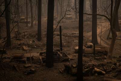
Forest Fires in Berry Creek, California
Ian King
For my Capstone 2 community, I have chosen Berry Creek, California. It is a small community of homes east of Chico in north central California. I have chosen it as I have a friend who lives near there. While she had some loss during the wildfires this last fall, she definitely fared better than the community of Berry Creek.
Berry Creek is threatened by forest fires. In the fall of 2018, some of the surrounding woodland was burned by the Camp Fire which destroyed some neighboring communities. While Berry Creek survived that fire, it did not survive the Bear Fire which was part of the North Complex Fire that burned the entire community to the ground starting on September 9th of 2020 (Berry Creek…, 2020). Berry Creek is vulnerable as it sits in highly wooded areas of California and, as we have been learning in class, the dryness of those areas due to the El Niño/La Niña cycle causes such areas to be highly susceptible to fires. When all the underbrush has grown due to the wet and cooler cycle, there is much more fuel for fires during the drier years like the one in fall 2020 continuing through winter. With weather forecasted to get hotter and drier, there will be even more destruction.
The impacts to the community were and are still certainly devastating. Nearly all the structures were destroyed, and 15 people were killed. The fire station and middle school burnt as well as almost all the other structures. It is also a poor community, with only one school. The approximately 60 children at the school are all on free or reduced-price lunches (La Ganga, 2020). It sounds like many will stay, but it will not be without a lot of help. It is still unclear where all that help might come from. Interestingly, one of the big issues is what to do with all the burnt trees. Seventy-five percent to 100 percent of the trees in the area are dead from the fire, and there is no good way to deal with them. Hauling them is neither profitable for a contractor nor environmentally friendly. They could be turned into biomass but there is no facility anywhere nearby (Urseny, 2020).
As for solutions, controlled burning of the underbrush is a small step that could have a substantial impact on preventing larger fires. Further care and reduction of global warming will also, of course, reduce the severity of the wet/dry cycles.
Sources
Berry Creek, California. (2020, December 17). In Wikipedia. https://en.wikipedia.org/wiki/Berry_Creek,_California
La Ganga, M. L. (2020, September 22). People in this California town didn’t have much. then fire took it away. The LA Times. https://www.latimes.com/california/story/2020-09-22/the-people-in-this-california town-have-much-to-begin-with-fire-took-it-away
North Complex Fire. (2021, January 22). In Wikipedia. https://en.wikipedia.org/wiki/North_Complex_fire#Bear_Fire
Polakovic, G. (2020, December 07). California appears to be in for a dry, warm winter, thanks to La Niña. USC News. https://news.usc.edu/179341/california-winter-forecast-dry-warm-la-nina-usc-experts/#:~:text=It’s%20so%20dry%20in%20California,role%20that%20the%20oceans%20play.&text=Climate%20change%20is%20in%20play,been%20around%20a%20long%20time.
Urseny, L. (2020, October 31). Grant helps with Berry Creek burned trees. Enterprise Record. https://www.chicoer.com/2020/10/30/grant-helps-with-berry-creek-burned-trees/.
Image source: https://s.hdnux.com/photos/01/14/03/57/19938275/9/ratio3x2_400.jpg
Madison Kinsley
Sonoma County resides in Northern California, and suffers from intense fires due to climate change. The threat of fires devastating the community of Sonoma County is not a new one. In October of 2017, the Tubbs fire destroyed over 5,300 homes and 126 businesses. It spanned 36,807 acres and, unfortunately, the fire also took 24 lives. The largest fire in Sonoma County history occurred from late October to early November of 2019. This fire destroyed 374 structures and spanned 77,758 acres across the county. While these fires were extremely devastating to the community, they are only a few of a long list of fires that has plagued the county for over a century, with the Guerneville Fire dating all the way back to 1923. This community is especially vulnerable to these fires because local climate change is happening rapidly, which is causing longer summers, drier weather, and more variable rain. Another reason this community is especially vulnerable is due to the demographics of its residents. Sonoma County has a large population of undocumented immigrants, estimated to be at least 20,000. This portion of the community is less likely to receive assistance and enroll in programs to help rebuild after fires due to fear of losing their immigration status or being deported. Another large portion of the community’s population are senior citizens, which are especially vulnerable due to their low mobility rates in the case of evacuation from the fires. The forecasted impacts of the threat to Sonoma Valley are glum, as the fires and their repercussions have become a regular occurrence in the lives of its inhabitants. Without significant efforts to reduce the effects of local climate change in this community, the residents will only suffer from more destruction. However, Sonoma County is well aware of this problem and has created multiple initiatives to solve it. Some of these solutions include creating more efficient buildings to save water and energy and supporting waste reduction through better practices for discarding waste. Other initiatives of the county include promoting clean energy to derive more energy from renewable sources and promoting the use of electric vehicles to encourage low carbon transportation. The most ambitious solution to this problem, however, was announced in 2021. The community plans to use Artificial Intelligence (AI) to defend itself against fires. The AI is supposed to detect fires early enough to give emergency personnel sufficient time to act and diminish them.
Sources
Admin. (2021). Preparing For Climate Change. Regional Climate Protection Authority. https://rcpa.ca.gov/.
Cohen, J. (2021, May 3). Planning for a Fire-Resilient Future in Northern California. Urban Land Magazine. https://urbanland.uli.org/planning-design/planning-for-a-fire-resilient-future-in-northern california/.
National Academies of Sciences, Engineering, and Medicine. (2020). Implications of the California wildfires for health, communities, and preparedness: Proceedings of a workshop. Washington, DC: The National Academies Press. https://doi.org/10.17226/25622.
Rodriguez, O. R. (2021, March 17). Sonoma county to use artificial intelligence against fires. AP NEWS. https://apnews.com/article/technology-fires-california-wildfires-artificial-intelligence-bf220a3dd2704815138d40dd3aa37db2.
Weber, J. B. (2020, May 12). A look back at wildfires on the North Coast. Santa Rosa Press Democrat. https://www.pressdemocrat.com/article/news/a-look-back-at-wildfires-in-sonoma-county-and-on-the-north-coast/?sba=AAS.
Wildfires and Their Threat to Paradise, California
Julia Kline
Paradise, California has suffered numerous fires over the last several years, with one of the largest being the Camp Fire. The Camp Fire took place on November 8, 2018 through November 25, 2018. The damage caused by the 2018 Camp Fire was incredible: the fire caused 85 fatalities and destroyed more than 18,000 structures. Leading up to the fire, in September 2020, Paradise residents noticed that the skies were filled with smoke and quickly began packing their belongings. Even though there were no known fires in the town of Paradise at that time, due to fire in areas near the town, an evacuation warning was issued, and the town was evacuated. While the cause of the fire in Paradise is often attributed to faulty equipment owned by the Pacific Gas and Electric Company, blame for the devastating fire in Paradise cannot be attributed solely to Pacific Gas and Electric Company’s equipment. Instead, blame for the fire must also be laid upon climate change. Because the earth has become increasingly warmer over the past century, locations such as Paradise, California – which already have extremely hot and dry summer weather – present conditions that make fires very easy to start due to the presence of abundant and dry vegetation.
There are several different impacts that wildfires are making not only upon the City of Paradise, but also in the State of California as a whole. We see things such as water quality decreasing, as well as the quality of air falling due to the presence of smoke from long-burning fires. In addition, mass droughts often precede periods of wildfires in areas such as Paradise, California; these droughts create a severe lack-of-moisture stress upon vegetation, which creates the perfect breeding ground for wildfires to spring up. These fires, and the droughts that often come before them, negatively affect not only humans, but animals and wildlife as well.
One way that Paradise, California is trying to assure that wildfires cannot occur again is to have The Pacific Gas and Electric Company bury their electrical lines underground. Also, an emergency alert system is being put in place which will notify residents of the town by phone of impending fire emergencies. Moreover, the City of Paradise as well as the State of California are creating emergency routes that will (hopefully) quickly and safely get the residents out of harm’s way in the event of wildfires. In addition, the City of Paradise is also tightening its building and structural codes and standards for homes and business in the hope that damages from any future wildfires can be mitigated. Finally, to prevent future wildfires, the State of California must do a better job of managing its forests by employing forest fire prevention techniques such as controlled burns to eliminate deadwood and other easily flammable materials.
Sources
Andone, D., & Becker, S. (2020, September 10). A wary and traumatized Paradise watches the raging inferno from nearby California fires. CNN. https://www.cnn.com/2020/09/10/us/paradise-california-wildfires-threat/index.html
Camp Fire (2018). (2021). In Wikipedia. https://en.wikipedia.org/wiki/Camp_Fire_(2018)
Lin II, R.-G., & Money, L. (2020, September 28). Paradise again threatened as deadly fires push toward towns gutted by 2018 inferno. Los Angeles Times. https://www.latimes.com/california/story/2020-09-28/paradise-again-threatened-by-california-fires
Robertson, A. (2019, May 15). Investigators confirm that PG&E power lines started the deadly Camp Fire. The Verge. https://www.theverge.com/2019/5/15/18626819/cal-fire-pacific-gas-and-electric-camp-fire-power-lines-cause
Science: Wildfire Impacts. (2021). California Department of Fish and Wildlife. https://wildlife.ca.gov/Science-Institute/Wildfire-Impacts
Temple, J. (2019, June 6). How a town destroyed by fire is trying to make itself fireproof. MIT Technology Review. https://www.technologyreview.com/2019/06/06/103003/paradise-california-wildfire-climate-change-rebuilding/
Joshua Kuplen
Napa Valley, located a couple of miles north of San Francisco, California, is home to around 500 wineries that produce the US’ best wine (Napa Valley fast Facts, 2021). Unfortunately, California is also home to the US’s worst wildfires. Napa Valley, in 2020, was burned in the “Glass Fire,” damaging 31 vineyards and destroying 11 vineyards (Villano, 2020). Over the past couple of decades, there has been a steady increase in the amount of dry material located north of Napa Valley. This increase of dry tinder accompanied by warmer and drier air brought by Diablo Winds. The Diablo winds make the Napa Valley area prone to fires. These hot and dry winds become devastating if the Northern California counties’ dry timber ignites. There has been a lack of forest management, leading to smaller fires in Northern California getting out of hand. The governor of California needs to work with forest management to implement a forest protection plan in the next couple of years, or the fires in western states will continue to rage. The Diablo winds are forecasted to become more intense. Oceanic temperatures are increasing, causing changes in oceanic pressure. The Pacific Ocean gyre off the coast of California has two main driving forces, the Pacific Decadal Oscillation (PDO) affecting 38N to 28N, and the North Pacific Gyre Oscillation (NPGO) affecting 48N-39N. California is a low-pressure system opposite to the high pressure in the PDO. In recent years, the PDO is becoming more of a neutral state due to the Aleutian Low-pressure cycle decreasing intensity (Fleischer, 2021). The change in pressure can alter how the wind currents from Northern Canada (the Diablo winds) affect California. The Pacific Ocean changing its pressure cycles to relatively constant pressure will cause warmer drier winds to move across California (Warm Phase of the Pacific Decadal Oscillation Fading, 2019). The threat of forest fires will continue to accelerate, just as our response to these wildfires should accelerate to combat the threat. Forest management is not enough to stop the fires from spreading. Napa Valley vineyards need to cut back dead vegetation and clear all vegetation from around the vineyards to decrease the fires spreading from the forests to the vineyards. Napa Valley should also have a protocol in place. Building a sprinkler system or constructing a tall wall around the vineyards will reduce the number of embers reaching the vineyards. The more protective measures Napa Valley residents and the government of California take, the chance of fires spreading in these beautiful vineyards will decrease.
Sources
Areas most affected by Wildfires. (2017, October 11). Maps of World. https://www.mapsofworld.com/answers/united-states/what-causes-california-wildfires/attachment/map-what-causes-california-wildfires/#
Blanchard, J. (n.d.). What Creates Dangerous Winds. The Chronical.
Fleischer, G. (2021, January 7). Oceans of Change: Recent Conditions in the North Pacific Are Dramatically Affecting Steelhead Survival. Wild Steelhead Coalition. https://www.wildsteelheadcoalition.org/news/ocean-conditions
Napa Valley. (2021). Seven Fifty Daily. https://daily.sevenfifty.com/regions/napa-valley/
Napa Valley Fast Facts. (2021, April). Napa Valley Vinters. https://napavintners.com/press/docs/napa_valley_fast_facts.pdf
Villano, M. (2020, November 4). Fire-ravaged California Wine Country: We’re still here. CNN travel. https://www.cnn.com/travel/article/california-wine-country-napa-sonoma-wildfires-tourism/index.html
Warm Phase of the Pacific Decadal Oscillation Fading. (2019, September 12). Climate Impact Company. https://climateimpactcompany.com/warm-phase-of-the-pacific-decadal-oscillation-fading-2-2/
Wildfires in Bodfish, California
Madison Lapetina, Political Science, College of Liberal Arts
Bodfish is a census-designation place in south Kern River Valley of California. According to Direct Relief, Bodfish is one of the most vulnerable communities to wildfires in California. In just 2020, over two million acres of land were burned across California, bringing high temperatures, strong winds, and heavy smoke that travelled far beyond the burn zone. Thirty-three people lost their lives, many lost their homes, and thousands had to evacuate and seek refuge in evacuation shelters. Climate change has only increased the number and severity of these wildfires. Lack of rainfall and warming temperatures have slowly dried out vegetation, turning it into kindling for fires (Pierre-Louis & Schwartz, 2020). Bodfish is especially vulnerable to these fires because it is not only surrounded by vegetation, but its disproportionate demographics makes it vulnerable as well. Twenty-nine percent of the population is 65 years or older, and 28 percent of the population is disabled. These people may have a hard time evacuating in the event of a wildfire, and due to their geographical location, it could be hard to reach them. Two percent of the population don’t have access to cars, meaning a fraction of Bodfish’s residents will not have a method of transportation out of Bodfish in the case of a necessary evacuation. The poverty rate is 29 percent, so if these people lose their homes to wildfires, they may not have enough to support themselves until finding a new place to live. Because of these poorer demographics, it will be extremely difficult for Bodfish to recover from a wildfire (Meyers, 2019).
Some solutions include the distribution of wildfire response packs. These packs would contain air purifiers, first aid kits, and other necessities and would be placed near communities vulnerable to wildfires, such as Bodfish. Other solutions include stricter regulations surrounding human-made fires and disposing of smoking materials, landscaping for fire resistance, and avoiding living near vegetation (9 Ways…, 2020). While these solutions won’t stop climate change and the wildfire crisis, they will prevent the start of fires that could have been avoided.
Sources
9 Ways to Prevent Forest Fires in California. (2020, September 29). One Tree Planted. onetreeplanted.org/blogs/stories/ways-to-prevent-forest-fires.
Meyers, T. (2019, October 12). Which California Communities Are Most Vulnerable to Wildfires? Direct Relief. www.directrelief.org/2019/07/which-california-communities-are-most-vulnerable-to-wildfires/.
Pierre-Louis, K. & Schwartz, J. (2020, August 21). Why Does California Have So Many Wildfires? The New York Times. www.nytimes.com/article/why-does-california-have-wildfires.html.
Fires in Shingletown, California
Amanda Monahan, Biology, Penn State University
All of Shingletown’s population (over 2,300 residents) lives in a very high fire hazard severity zone. This classification means that wildfires are likely to happen in this area, and will likely be very hard to stop (due to an abundance of dry foliage, trees, etc.). The population of Shingletown is also extremely hard to keep safe/evacuate. The median age in this community is 61, and the main way in and out of the city is a very narrow, winding Highway 44 (Sabalow et al., 2019). Combine all of these factors with globally rising temperatures and less rain, and you end up with a disaster waiting to happen.
It is forecasted that Shingletown will face wildfires in the coming wildfire seasons. These wildfires have the potential to be devastating, with some even claiming that the area has the makings for a fire comparable to that of Paradise (home to the infamous 2018 Camp Fire). However, some steps are being taken to mediate this risk, and, if these steps are kept up with/maintained, it is possible to prevent such a disaster from taking place. For example, the governor made plans to trim over 1,000 acres of vegetation along Highway 44 (Sabalow et al., 2019). He listed this as one of the top priorities in the area. Locals have also been made aware of the fire danger in the area. They are encouraged to have plans to escape if a blaze is to spark up, and a “back up” plan in mind as far as where to stay, what to do with possessions, etc.
To further protect this area, many more steps can be taken. Camping and other activities in the dense, dry forests can be limited and/or monitored. Fire safety in these situations should be heavily stressed, and all individuals planning to use fire in these areas should be made aware of the dangers. Also, all house roofs should be built with non-flammable materials (tile, asphalt shingles, etc.). Further measures can also be taken to fire- proof houses, as houses are often more likely to catch on fire than the forests surrounding them.
Sources
Sabalow, Ryan, et al. (2019, April 11). These California Communities Could Be the next Paradise. Is Yours One of Them? The Sacramento Bee. www.sacbee.com/news/california/fires/article227589484.html.
Kevin Mouck, Statistics, Eberly College of Science
The state of California has several areas at severe risk for wildfires. One of these towns is Cambria, located by the shore between San Francisco and Los Angeles. With a population below 6,000 people, Cambria is a small town intertwined with many trees. The majority of trees are Monterey pines which have a high mortality rate, causing dead vegetation to lie on the forest floor. With the increasing temperatures and droughts in California, these dead trees will contribute to the rapid spread of an existing fire that has the potential to wipe out the town of Cambria. The state of California has already seen unprecedented amounts of giant forest fires that have burned thousands of acres. In 2020, double the number of acres of California land were burned than what occurred in 2018. This spells trouble for the town of Cambria as they are in a region with a high severity risk to wildfires. As these fires become both more frequent and intense, Cambria could be caught in the middle of a blaze that destroys the city. Another issue with the town is that it contains several winding roads and few exit points that make evacuation and access for emergency vehicles difficult. The solutions to the fire threat involve the removal of the dead brush, like the Monterey pines, as they act as fuel to an already raging fire. If these dead trees were to ignite, the town would be destroyed with little warning time for evacuation. Another way for the small town to try to find the solution is to advocate to the state and federal government about more regulations in carbon emission policies so temperatures do not rise too high. And with the evacuation plan, the town needs to limit where vehicles can be parked to allow access to fire engines, as well as informing citizens to create a travel bag that can be quickly transported to a safe location in case of immediate evacuation.
Sources
Cambria. Is it Five Minutes to Midnight in Cambria? An Update on the Risk of Catastrophic Fire. Cambria: Cambria Fire Risk, 2017.
Elbein, S. (2021, January 21). What the Complex Math of Fire Modeling Tells Us about the Future of California’s Forests. MIT Technology Review. www.technologyreview.com/2021/01/18/1016215/complex-math-fire-modeling-future-california-forests/.
Ryan Mutter
Wildfires have plagued California since before the 1950s, but in recent years, these fires have become increasingly out of control. In 2018, the worst fire in California history struck a community in Butte County. We will be focusing on Paradise, California which was mostly destroyed in this fire that killed 85 people and burned more than 18,000 buildings (Richards, 2019). With ever-warming temperatures caused by climate change, along with droughts, these fires are becoming harder and harder to prevent and manage. This fire, coined the “Camp Fire” because of its origin in Camp Creek Road, was started from faulty equipment from the Pacific Gas and Electric Company who later pleaded guilty to 84 counts of manslaughter (Chabria, 2020).
These fires happen very fast and leave little time for people to evacuate. In The Camp Fire that ravaged Paradise, California, most of the damage occurred in the first 4 hours. The fire took 17 days to be fully contained with the help of the year’s first winter rainstorm (Camp Fire…, 2018). Many of the people left behind were elderly or disabled people who could not evacuate in time. Strong winds added to the spread of the fire, creating even more chaos and destruction.
Research shows that 12 million people living in communities such as Paradise, California that are at-risk for wildfires are unable to prepare and recover from such disasters. Furthermore, minority groups within these communities are at an even higher risk of vulnerability and lack the preparation and recovery necessary to overcome such tragedy. Many of these disasters cost billions of dollars in damages, much of which is not covered by insurance, leaving residents stranded with little hope of recovery (Richards, 2019).
Paradise was threatened once again by another wildfire named The North Complex fire, but ultimately was not affected. These continued fires in areas of California go to show just how volatile the situation is. Continued climate change that increases temperatures and decreases rainfall only adds to the already hostile environment. The town of Paradise continues to rebuild and is still cleaning up some of the destruction left behind from The Camp Fire of 2018. The town is sticking to a long-term recovery plan to better be prepared in case of another wildfire. Ongoing cleaning of debris along with the construction of 500 single-family homes and 1,400 building permits is only the beginning of the recovery of Paradise, California (McKay, 2020). The town has developed many new strategies in preparation for another wildfire, including improved evacuation routes, more efficient construction processes, a new fire station, fire safety education for the community, a new civic center, fire-resistant buildings, wider streets, walkable paths off the main roads, and most importantly, an early warning system to better alert the community of possible threats (McKay, 2020).
All in all, these solutions for the town of Paradise could prove to be successful in the event of another wildfire, but the root issue remains. Unless we, as a global unit, adhere to strict emission guidelines to reduce greenhouse gasses in our atmosphere and at least curb an increase in global temperature, weather disasters like The Camp Fire in 2018 will continue to decimate communities like Paradise.
Sources
Chabria, A. (2020, September 9). Explosive fire again threatens Paradise, town devastated by California’s deadliest blaze. Los Angeles Times. https://www.latimes.com/california/story/2020-09-09/paradise-devastated-by-californias-deadliest-fire-again-threatened-by-new-blazes
McKay, J. (2020, November 19). After Camp Fire, Paradise, CA, Works on Long-Term Recovery. Government Technology. https://www.govtech.com/em/disaster/After-Camp-Fire-Paradise-CA-Works-on-Long-Term-Recovery.html
Richards, R. (2019, July 25). After the Fire: Vulnerable Communities Respond and Rebuild. Center for American Progress. https://www.americanprogress.org/issues/green/reports/2019/07/25/472738/fire-vulnerable-communities-respond-rebuild/
Camp Fire – 2018 California Wildfires. (2018, November). United States Census Bureau. https://www.census.gov/topics/preparedness/events/wildfires/camp.html
Wildfire in Flagstaff, Arizona
Eric Myskowski, Meteorology, College of Earth and Mineral Science
Another place that will have challenges with climate change is Flagstaff Arizona. Flagstaff is a naturally vulnerable area because it relies on inconsistent mountain snowfall for most of its winter precipitation and inconsistent summer precipitation in the form of the southwest monsoon. Even though these two events currently provide enough water for the city, warming temperatures could easily change this. With rising temperatures, this will make more of the precipitation that falls in the winter rain. This will runoff quickly and the ground will dry out before the drier season in the summer. This is compared to snowfall that slowly melts all the way into the summer, providing a more sustainable water source. This will lead to water shortages in the summer. Also, some projections cause the jet stream to stay too far north in the winter, preventing the city from receiving enough precipitation to begin with.
The other time of year that Flagstaff receives most of its precipitation is with the monsoon in the summer. A weather pattern shift brings up moisture from the Gulf of Mexico and the Pacific Ocean and this causes thunderstorms. Unfortunately, due to climate change, these are forecasted to become more isolated but stronger. This means that sometimes, it will receive too much rainfall while other times, it will receive too little. This will also help drive the possible water shortages. One last factor is rising temperatures. Increased temperatures lead to faster evaporation, something that dries out the ground and reservoirs faster.
There are several proposals to combat this. The first is to use drought tolerant landscaping. Homes can be landscaped to drastically reduce the amount of water usage, thus keeping more water in streams and reservoirs. Another plan is to thin the adjacent forests. Overcrowded forests soak up too much water from the ground, drying it out and causing streamflow to decrease. Thinning forests helps keep water in the ground by selectively cutting these overcrowded forests. This also helps prevent destructive wildfires, another bonus for the city. The last proposal is to mandate water restrictions if necessary. Even though this is one of the least preferred options, it would still become helpful in anomalously dry years in the future.
Sources
How the Climate Crisis is Affecting Arizona. (2019, November 25). The Climate Reality Project https://www.climaterealityproject.org/blog/how-climate-crisis-affecting-arizona
Restoring Arizona’s Forests for a Secure Water Future. (n.d.). The Nature Conservancy. https://www.nature.org/en-us/about-us/where-we-work/united-states/arizona/stories-in-arizona/restoring-arizonas-forests/
Fires in Nevada City, California
Megan Neely
Nevada City, California, located northeast of Sacramento, was badly burned during the Jones Fire, one of the many fires that raged across the state in 2020. It burned a total of eleven days and destroyed 705 acres (Jones Fire…, n.d.). 2020 was California’s worst and most destructive fire season in history (2020 Atlantic…, 2020). The fire was ultimately started by a lightning bolt (Jones Fire…, n.d.). In August, when the Jones Fire occurred, a heat wave coupled with strong winds heightened the wildfire. On August 17th, the day the fire started, the temperature reached a high of one hundred degrees Fahrenheit (Nevada City…, n.d.).
The winds that escalated the fire are known as the Santa Ana and Diablo winds. These winds are “two hot, dry currents that blow through California north-east to south-east” (Mulhern, 2020). They can create “cloudlike plumes of smoke that reach 40,000 feet in height” (Wilson, 2020). The heat wave, coupled with other fires that started, gave the winds perfect conditions to make the fire worse. Based on fire fuel and fire frequency data from National Geographic, Nevada City is in a very high-risk area for fires in the future (Helvarg, 2021).
The city is at such high risk because of the brush, cedar, and pine prevalent in and around the town. Most buildings are made of wood, too. In addition, the town is surrounded by steep hillsides. The streets are also very narrow, which makes it harder to evacuate (Sabalow, n.d.). One of the measures the town has taken to limit the risk is to create a “‘Goat Fund Me’ campaign to raise 25,000 to hire farmers to use their goats to eat dense brush in more than 450 acres of city-owned greenbelt” (Sabalow, n.d.). On a larger scale, the use of controlled, low intensity fires may reduce the severity of wildfires in the future. These fires will help control forests and brush that often make these disasters worse (Helvarg, 2021).
Sources
2020 Incident Archive. (n.d.). Cal Fire Department of Forestry and Fire Protection. www.fire.ca.gov/incidents/2020/.
Helvarg, D. (2021, February 10). How Will California Prevent More Mega-Wildfire Disasters? National Geographic. www.nationalgeographic.com/science/article/how-will-california-prevent-more-mega-wildfire-disasters.
Jones Fire. (n.d.). Cal Fire Department of Forestry and Fire Protection. www.fire.ca.gov/incidents/2020/8/17/jones-fire/.
Jones Fire Recovery: Nevada County, CA. (n.d.). MyNevadaCounty.com. https://www.mynevadacounty.com/3076/Jones-Fire-Recovery.
Nevada City, CA Weather History. (n.d.). Weather Underground. www.wunderground.com/history/daily/us/ca/nevada-city/KSMF/date/2020-8-17.
Sabalow, R. (n.d.). These California Communities Could Be the Next Paradise. Is Yours One of Them? The Sacramento Bee. www.sacbee.com/news/california/fires/article227589484.html.
Mulhern, O. (2020, September 18). Santa Ana and Diablo Winds to Worsen the California Wildfires. Earth.org. https://earth.org/data_visualization/santa-ana-and-diablo-winds-to-worsen-the-california-wildfires/.
Wilson, S. (2020, September 10). Oregon Wildfires Race through Small Towns, Scorching Hundreds of Buildings. The Washington Post. www.washingtonpost.com/national/oregon-wildfires-climate/2020/09/09/ca7beec2-f2d8-11ea-a852-eb7526c580f4_story.html.
Sarah Raver, Chemical Engineering, College of Engineering
In the past few years, California has been a common focus in the news due to devastating wildfire events that have caused tremendous property losses, fatalities, injuries, air pollution, and many other negative effects. Much of California is at risk for moderate or severe wildfires due to dry, hot, and windy conditions for much of the summer months; these factors all contribute to the fueling of fire (List of…, 2021). Some communities, however, are at even higher risk of fires than others, due to geographical features and socio economic factors. One town in particular that is at a very high risk is Lewiston, CA. This town is very vulnerable because they have an above-average percentage of their population that is in poverty, elderly, or disabled. These factors contribute negatively to fire preparedness, as they may not be able to evacuate quickly, protect their property, or recover from damages caused by fires (Meyers, 2019). Wildfires can have lasting impacts on health due to the air pollution; therefore, people whose health is already at risk, or who may not have access to quality healthcare, are more likely to suffer from these effects. In an area like Lewiston, there are very high temperatures in the summer months, combined with very low precipitation (Lewiston, California…, 2021). Along with fires comes the risk of mudslides. As fires burn off the vegetation along hillsides, the ground becomes vulnerable to mudslides (Bice & Bralower, n.d.), a problem that has occurred in Lewiston (Lewiston, California…, 2021). Fires are becoming more common not only due to effects of climate change, but also due to human impacts. Many fires are caused by arson, machinery sparks, or loss of control of what were supposed to be controlled burns (Bice & Bralower, n.d.). For example, around the year 2000 in Lewiston, a burn of thistle (a weed) got out of control, leading to the destruction of 23 homes and forcing many people to evacuate the area (Egan, 2001). As climate change worsens, California (and Lewiston) are likely to experience more contrast in the wet seasons and drought, which will worsen fires, as precipitation pushes growth of vegetation, which dries out later and becomes fuel for fire during a drought (Bice & Bralower, n.d.). It is predicted that there will be a 77% increase in the area of land burned by fires in California by 2100 (Milman, 2020). Some ways that fire threats can be lessened include planting of native species, removal of invasive species (which fuel fires) in safe ways, and improving upon the evacuation and containment plans to ensure as many people are safe from the fires as possible (Bice & Bralower, n.d.). Some also suggest a restructuring of residential areas to avoid high-risk areas and to engineer fire-protected communities (Milman, 2020). Fire is part of the climate in areas like California, but due to climate change and human effects, it has gotten out of control. What was once natural burning of certain areas has led to so-called “megafires” (Milman, 2020).
Sources
Bice, D. M., & Bralower, T. J. (n.d.). Course Home Page. Earth in the Future. https://www.e-education.psu.edu/earth103/node/508
Egan, T. (2001, August 31). ‘Controlled’ Blaze That Wasn’t Haunts Firefighters in California. The New York Times. https://www.nytimes.com/2001/08/31/us/controlled-blaze-that-wasn-t-haunts-firefighters-in-california.html
Lewiston, California. (2021). City-Data.com. http://www.city-data.com/city/Lewiston-California.html
List of California wildfires. (2021). In Wikipedia. https://en.wikipedia.org/wiki/List_of_California_wildfires
Meyers, T. (2019, July 30). Which California Communities are Most Vulnerable to Wildfires? Direct Relief. https://www.directrelief.org/2019/07/which-california-communities-are-most-vulnerable-to-wildfires/
Milman, O. (2020, September 19). ‘Too late to stop it’: California’s future hinges on managing megafires. The Guardian. https://www.theguardian.com/us-news/2020/sep/18/california-fires-wildfires-future-housing
How Global Changes Affect Smaller Communities with Fire
Emma Richardson, General Arts and Sciences, Penn State Behrend
Reading the instructions for this assignment, I knew where I wanted to focus my attention: The Amazon Rainforest. The fires in 2019 were horrifying to hear about (the little coverage we in the States were able to see), and 2020 also had an intensely trying fire season. During my research, I found some communities that have one major thing in common: the Xingu River. This connection makes these smaller groups a larger community affected by the daily threat of deforestation and fire. The Bolsonaro administration in Brazil focuses attention on profit over people, and on the health of the nation’s economy more than the health of the nation’s people and land. Too often, indigenous communities are underserved and overexploited by those in power, and the Xingu River community has also been forced into this troubling position. A major loss for this community was the green light and completion of the Belo Monte Dam, a project that was heavily protested for years. This dam has affected fish migration, changed water availability to these already endangered indigenous peoples, and has contributed to deforestation. The combination of losing this fight, the high probability of more dams in the future, continual deforestation from ranching and logging, and increasing drought conditions can only mean one thing: the problem will get worse. Fires, which are not normally part of life for this region, may and will happen with more frequency because of this cycle of drought and deforestation. More of the land has been compromised by developers/farmers and each new section of forest that is removed raises the stakes for neighboring sections of forest that are now more susceptible to fire.
In addition to those already displaced by the dam and the previous fires, more indigenous folk are at risk of displacement. Given how outside communities treat their indigenous counterparts (violently and lacking in respect), these people are finding themselves in dangerous situations with more frequency. A key factor in stopping this madness is getting as much land back into the hands of the indigenous community as possible. Then, they will have control and can prevent any future loss of land and habitat for both people and animals. Although the Belo Monte Dam was completed, we can fight harder to stop any future dam building that will only exacerbate and redirect these problems. There are many organizations that are fighting to get autonomy back for the indigenous peoples of the Amazon, the Xingu River community among them. This is the most important solution. The indigenous community knows their land best and the more say they have in how it’s treated, the more hope we have for our future.
Sources
Belo Monte Dam. (2021, January 24). In Wikipedia. en.wikipedia.org/wiki/Belo_Monte_Dam#Environmental_effects
Corbin, A., & Tindall, A. (2007, August 1). Xingu River System – Brazil. Sacred Land. sacredland.org/xingu-river-system-brazil/
Correa, L., Lobao, M., & Kaiser, A. J. (2019, August 29). Brazilian Indigenous People Speak out as Amazon Fires Rage. PBS. www.pbs.org/newshour/world/brazilian-indigenous-people-speak-out-as-amazon-fires-rage
2020 Amazon Fires. (2020, November 6). Rainforest Foundation. rainforestfoundation.org/our-work/special-initiatives/2020-amazon-fires/
Hannah Richardson
California is notorious for having devastating wildfires. As the state experiences rising temperatures and strengthening winds, wildfires are becoming more common and damaging to communities. In 2017, Coffey Park, a community of many homes in Santa Rosa, California, was torn apart by a fire. A handful of people died, and thousands of evacuations were issued to the residents of the neighborhood. Unfortunately, this was not the only fire that devastated Coffey Park. The community has a long history of fire-related issues because of its susceptibility to these types of threats.
Coffey Park is vulnerable to wildfires because it lies just below a mountain known as the Tubbs. When the mountain catches on fire and makes its way toward the neighborhood, residents are completely defenseless. Coffey Park was particularly vulnerable during the disastrous fire of 2017 because it was not inside the fire hazard severity zone on the official map that determines which areas in Santa Rosa need fire resistant buildings. In addition, weather is also a major factor in the community’s susceptibility to fires. High winds and temperatures coupled with low humidity makes fires easier to start and spread to surrounding areas.
The neighborhood’s vulnerability to wildfires has an obvious impact on its residents and vegetation. People who live in Coffey Park run the risk of losing their home and even family members to these devastating fires. Additionally, animal and plant life is affected by the fires.
Wildlife habitats are destroyed, and greenery burned. The emissions that are released by fires, such as carbon dioxide and methane, can be harmful and dangerous to human health. Residents who live in Coffey Park and constantly breathe in this potent air are at higher risk for health problems later in life.
In order to prevent these fires from destroying the neighborhood any further, contractors could construct fire-resistant homes. By adding these homes to the neighborhood, fires are less likely to destroy houses and everything that is inside. Although a single community cannot stop global warming, California as a whole can work together to reduce carbon emissions so that the temperatures do not continue to rise. However, climate change is tricky to combat, and it is unlikely that we can stop it anytime in the near future. The people of Santa Rosa can at least help to prevent fires from starting by carefully disposing of materials that could cause a fire. It is difficult to come up with a solution to this threat, because the climate and weather have such a huge impact on it.
Sources
Fuller, T. (2017, October 10). ‘Everything Was Incinerated’: Scenes From One Community Wrecked by the Santa Rosa Fire. New York Times. https://www.nytimes.com/2017/10/10/us/santa-rosa-california-fire.html
Smith, D. & Agrawal, N. (2017, October 15). Despite clear risks, Santa Rosa neighborhood that burned down was exempt from state fire regulations. LA Times. https://www.latimes.com/local/lanow/la-me-ln-coffey-park-explainer-20171011-story.html
Malden, Washington and Wildfires
Caitlin Ruiz Jimenez, Labor and Employment Relations, College of Liberal Arts
On September 7th, 2020, Malden, a small town in Washington, went up in flames, resulting in complete destruction of over 80% of the town’s land, homes, and businesses. The fire was one of over 75 massive wildfires rapidly destroying towns across the United States in 2020. Malden is a small town, home to around 200 people at the time of the fire. In a town that size, a wildfire can not only cause damage to a community, but it can also completely decimate it.
Malden was, and is, particularly vulnerable to wildfire destruction because of the presence of its dry fields and standing timber. As the land in many parts of the area becomes drier and rainfall decreases, one spark (coupled with gusty winds) can cause a quick-moving disaster that will bring towns to ashes in a matter of hours. Ecologists predict that this problem will only continue (and likely get worse) as the long-term effects of climate change become more apparent.
Although there is no one solution that will permanently stop the occurrence of wildfires, there are several things that can be done to help prevent them from forming (or to prevent them from spreading). One important task that residents of states such as California and Washington must focus on is improving the health of forests. This will ensure that trees do not rapidly die out and become fuel for destruction. Residents of towns in areas prone to wildfires need to ensure that their property is maintained, and any dry, dead vegetation is promptly removed. Trees in residential areas need to keep limbs 10 feet up to prevent fires from spreading to the tops of the trees. They should also be trimmed so that no branches are closer than 5 feet apart. In the future, it will be critical for residents of Walden (and all other towns at risk for wildfires) to prepare both themselves and their property to aid in the extinguishment of fires.
Sources
Burnside, T., & Silverman, H. (2020, September 08). 80% of the buildings in an eastern washington town were destroyed during a Labor Day firestorm. CNN. https://www.cnn.com/2020/09/08/us/malden-washington-fire-town-destroyed/index.html
Katkov, M., & Chappell, B. (2020, September 08). Fast-Moving Wildfire DESTROYS 80% of Small Town in Eastern Washington State. NPR. https://www.npr.org/2020/09/08/910578980/fast-moving-wildfire-destroys-80-of-sma ll-town-in-eastern-washington-state
Lake, A., & Lake, A. (2020, September 15). ‘This won’t be over soon’: WA researchers analyze severe fire seasons. KXLY. https://www.kxly.com/this-wont-be-over-soon-wa-researchers-analyze-severe-fire-seasons/
Prepare for wildfire: Wa – dnr. (n.d.). DNR WA.gov. https://www.dnr.wa.gov/programs-and-services/wildfire/wildfire-preparedness
Wildfire Devastates Washington Town of Malden. (2020, September 08). NPR. https://www.npr.org/2020/09/08/910788722/wildfire-devastates-washington-town-of malden
Ethan Ruschman, Political Science BS, College of Liberal Arts
In 2020, some of the worst wildfires that Australia has ever seen made it to a small town called Mogo. Mogo is a former gold-mining town in southeastern Australia with natural water springs just beneath the surface. It had never burned in recent memory, even though it is right next to the Australian bush. In January of 2020, the wind brought a firestorm that destroyed a large portion of Mogo’s main street. Climate change has brought with it higher temperatures, increasing the chance of large droughts and dryer bush has pushed the at risk areas of Australia right up to Mogo’s doorstep. The temperature of Australia has increased by 1.44 degrees Celsius since 1910. From 2013 to 2019, seven of the nine warmest years in Australian history were recorded. With these higher temperatures, it is very likely that these fires will continue to ravage across Australia and once again hit Mogo. What can Mogo do to protect itself? This is all being created by climate change, so one thing that Mogo and the rest of Australia could do to combat this is to meet it’s Paris agreement goal of a 26% reduction to carbon emissions by 2030, when based around 2005 levels. One of the best ways would be for a more professional, better trained fire department in Mogo that is specially trained to deal with large fires like what we saw in 2020. They would have better equipment, learn to dig ditches and create control lines. Possibly, another solution would be to have some control lines already in place that are constantly cleaned of brush so as to make it harder for the fires to get to the town in the first place. Additionally, investing in making the town less burnable would help. For example, there are coatings that you can place on buildings to make them more resistant to heat. Having mandates that you must clean out debris such as dead leaves and other tinder capable substances from roofs and gutters is another fix.
Sources
Australia faces more fires, drought as climate continues to heat. (2020, November 13). Al Jazeera. https://www.aljazeera.com/news/2020/11/13/australia-faces-more-fires-drought-as-climate-continues-to-heat
Fuller, T., & Kwai, I. (2020, January 6). The Springs Ran Dry. Then This Australian Town Burned. The New York Times. https://www.nytimes.com/2020/01/06/world/australia/fires.html
Whiteley, P. O. (2007, October 22). 5 ways to protect your home from wildfire. Sunset. https://www.sunset.com/garden/landscaping-design/5-ways-to-protect-your-home-from-wildfire
The Impact of Fires on Paradise, California
Katriel Simpson, Computer Engineering, College of Engineering
California is known to be prone to wildfires, however, the year of 2020 has been the most catastrophic. In just this year alone, there had been over 9,200 fires that burned around 4.2 million acres. It is known that fires cause a lot of physical damage to homes, property, as well as taking human lives, but it is actually the chemical and particle aftermath that can pose a more damaging threat. By tests conducted from previous fires, including the Tubbs Fire in Paradise in 2017, toxic chemicals such as benzene penetrated the water supply and got distributed all over the area, which could have caused short- and long-term cancer, as well as a list of other health conditions. After the fire in 2018 that almost leveled Paradise, the amount of benzene in the town’s drinking water was up to 2,217 parts per billion, which is extremely high. Health authorities state that short-term exposure to just 26 parts per billion is dangerous, and long-term exposure is dangerous at just one part per billion. Other volatile organic compounds and chemical substances released by wildfires also end up in the water supply by means of runoff and other processes (Hornberry, 2020). Because of this chemical release by wildfires, Paradise is extremely vulnerable to not only said wildfires, but serious health risks from exposure to toxic chemicals in the air and water supply, post-blaze. If no solutions are found and carried out for the town of Paradise, the constant attempt of rebuilding fire after fire will continue by residents who cannot afford to move to a safer area, possibly until the town is completely evacuated or utterly destroyed by another wildfire. To avoid this situation and keep Paradise from going through another harrowing experience, a list of 40 long-term recovery projects for Paradise were created. This includes better transportation methods for locals and emergency responder teams, and an advanced plan for fuel management. One of the most promising projects is forming a dual-purpose greenbelt formed by healthy, green plots. By obtaining land around the perimeter of Paradise, it would serve as a buffer between the blaze and the town and would keep the fire from being fueled any further by dry, dead plant material. This also gives any first responders an entryway, as well as easy access for crews to maintain the area (Bliss, 2020). Hopefully, progress is made with these solutions to ensure the residents of Paradise – to a degree, that relocation or decimation of the town may not be for some time and the fires can possibly become manageable. With the possibility of maintaining wildfires, and hopefully a new water management system, the safety of the residents’ health can be resolved by significantly reducing the chemical release into the water supply and finding a safer way to distribute drinking water to residents.
Sources
Bliss, L. (2020, August 25). The Price of Saving Paradise. Bloomberg. www.bloomberg.com/news/articles/2020-08-25/a-california-town-s-bold-plan-to-defeat-wildfire.
Horberry, M. (2020, October 2). After Wildfires Stop Burning, a Danger in the Drinking Water. The New York Times. www.nytimes.com/2020/10/02/science/wildfires-water-toxic.html.
Ethan Rothermel, Mechanical Engineering, Penn State College of Engineering
In the late summer of 2020 amidst a worsening global pandemic, wildfires raged across California’s Napa Valley. One specific grouping of fires called the L.N.U Lightning Complex grew to a size of over 300,000 acres (No End…, 2020). Hundreds of homes were either damaged or destroyed by the fires, and civilian deaths and injuries resulted from the blaze that lasted into early October. Like most wildfires in California, the L.N.U fire started as a result of multiple lightning strikes which took place during the dry heat of summer. Smoke from the fires reached as far as Nebraska and made the air extremely unsafe, especially during a pandemic. The pandemic added another puzzle for California officials to solve, as evacuation centers ran the risk of spreading disease in an already hard-hit state. With already overrun hospitals treating coronavirus patients, the air quality threatened to inflame lungs further and send more people to the hospital (No End…, 2020). Even during a regular year these wildfires would have been extraordinary, but with a global pandemic at hand, the fight became a lot more complicated.
Climate change undoubtedly played a part in the large amount of lightning strikes in the Napa Valley, which totaled 11,000 in a 72-hour span (No End…, 2020). With warmer air fueling more updrafts in storms due to climate change, the frequency and magnitude of lightning strikes will only increase in areas such as Napa Valley. Vegetation that was ignited on the ground was also drier because of increased heat waves due to higher global temperatures (No End…, 2020; Leman, 2020). When areas in California such as Napa experience such intense heat waves, the low-lying brush becomes perfect fuel for the continuous spread of wildfires. Drier conditions as a result of climate change have also led to less snow in the Sierra Nevada mountains, which leads to less runoff water to quench the low-land vegetation (Leman, 2020). The summer of 2020 saw nearly eight times the amount of acreage burned than in the 1970’s, and increasing global temperatures is a big reason (Leman, 2020). As California braces for another intense wildfire season in 2021, communities like Napa are still recovering from 2020. Vegetation does not grow back immediately, and what is there may easily burn again this summer. Properties will once again be burned and damaged by the raging fire, and people will be forced to evacuate their homes for some time or even permanently. This problem is not going away and will continue to worsen in the decades to come as global temperatures fuel more intense lightning strikes and dry out more brush. While California does employ over 10,000 first responders to fight wildfires each year and recruits other states to help out during surges, eventually the task of controlling larger fires will become too much to handle on a consistent basis (No End…, 2020). Climate change is what really needs to be addressed head-on to stop global temperatures from rising further (Leman, 2020). By 2100, wildfires in the Napa Valley could be so out of control that the area could become uninhabitable for good.
Sources
No End in Sight as Blazes Keep Growing in California. (2020, August 21). The New York Times. https://www.nytimes.com/2020/08/21/us/california wildfires.html.
Leman, J. (2020, August 24). Over 30 Wildfires Are Burning in California Right Now. Popular Mechanics. https://www.popularmechanics.com/science/environment/a29623250/california-fires/.
Fire in Greenville, California
Matthew Bowers, Earth Sustainability Certificate, World Campus
For the historic Gold Rush town of Greenville, California, fire is a threat that has impacted the community since its establishment. Back in 1881, a fire destroyed most of its Main Street, but the town rebuilt and recovered. Smaller fires throughout the 20th century kept Greenville on edge, but relatively unscathed (Dowd, 2021). However, the 2021 Dixie Fire – the second largest fire in California’s history – once again obliterated the town (Cal Fire, 2021). Greenville is vulnerable to fire due to its location combined with the affects of climate change. Located 150 miles north of Sacramento, Greenville is currently under D3 – Extreme Drought (the second highest drought classification behind D4 – Exceptional Drought). With 87.9 percent of California listed as experiencing extreme drought, the fire season is capable of lasting year-round, as there is not sufficient water to sustain ecosystems and agricultural practices (NOAA & NIDIS, 2021). As a result, the landscape is covered in dry, thick brush, which is easy fuel for fires. Drought, combined with strong winds, allowed the Dixie Fire to quickly take over Greenville with little hope of fighting the fire. Overall, three-quarters of structures were lost in the early August blaze (Kasakove et al., 2021). The forecasted impacts on the community of Greenville are grim due to the effects of climate change. While the town can ultimately rebuild from this most recent fire, it is still within a region of California that is prone to extreme drought and fires. While many residents are loyal to their historic town, it is also a relatively small, isolated town of 1000 people, so the economic impact is substantial, with some business owners stating that they do not plan on rebuilding (Kasakove et al., 2021). Throughout California, average temperatures are expected to rise between 5.6- and 8.8-degrees F in the next 50 years, and the climate is expected to get drier. In addition, fires are projected to become more frequent and intense. By 2050, the mean area burned by wildfires could increase in upwards of 75%, putting communities like Greenville at an even higher risk (Lieberman, 2018). A possible solution to decrease wildfire threat in the future involves thinning forests. Forests that are unmanaged end up growing substantial amounts of understory vegetation during the rainy season, which as this vegetation dies and dries out during droughts, creates fuel for fires to flourish (Ring, 2019). Effective forest thinning around the town of Greenville could prevent existing fires from approaching the town, or at least reduce the severity of the fire and allow time for firefighters to respond. Overall, as the residents of Greenville recover from the destruction of the Dixie Fire, they are faced with the ever-present challenge of living in an area where threats from wildfires will only get worse.
Sources
Cal Fire. (2021). Top 20 Largest California Wildfires. Fire.ca.gov. https://www.fire.ca.gov/media/4jandlhh/top20_acres.pdf
Dowd, K. (2021, August 6). Before and after photos show what remains of historic California town razed by Dixie Fire. SFGATE. https://www.sfgate.com/california-wildfires/article/greenville dixie-fire-main-street-buildings-lost-16366580.php
Kasakove, S., Correal, A., & Taylor, D.B. (2021). ‘We lost Greenville’: A California town is overrun by the Dixie Fire. The New York Times. https://www.nytimes.com/2021/08/05/us/dixie fire-greenville-california.html
Lieberman, B. (2018). Climate change impacts in California by 2100. Yale Climate Connections. https://yaleclimateconnections.org/2018/10/climate-change-impacts-in-california-by 2100/
NOAA & NIDIS. (2021). Current U.S. Drought Monitor Conditions for California. https://www.drought.gov/states/california
Ring, E. (2019). Long-term solutions for California wildfire prevention. California Policy Center. https://californiapolicycenter.org/long-term-solutions-for-california-wildfire-prevention/
Positive Feedback Systems Set Fire to Paradise, California
Anna Capria, Biobehavioral Health with a minor in Biomedical Ethics, Penn State University
Two of the factors impacting climate change are forcings, or initial drivers, and feedback mechanisms. An initial driver is a force that warms the planet, such as the sun’s rays, greenhouse gases, and other airborne particles. Feedback mechanisms are processes that amplify or diminish the impact of an initial driver. Positive feedbacks amplify warming while negative feedbacks diminish it (Buis, 2021). In the case of wildfires, they are both initial drivers and positive feedback mechanisms (Buis, 2021; Lashoff, 2018). Wildfires are initial drivers of climate change because they produce carbon dioxide and smoke, including brown and black carbon, depending on the fuel and type of combustion (Buis, 2021). However, wildfires are also positive feedback mechanisms because they destroy millions of acres of forests, which reduces carbon uptake by plants and trees (Lashoff, 2018). Wildfires are on the rise, and their impact on communities can be devastating (Wildland Fire…, 2021).
For example, in 2018, 85 people in the small town of Paradise, California died in the largest wildfire in the United States (Seigler, 2021). Paradise is a town of approximately 21,000 people in northern California (Paradise, CA, n.d.). Known as the Camp fire, this wildfire destroyed much of the town, which remains vulnerable to wildfires based on its location. In fact, the second largest wildfire in the United States, the Dixie fire, burned just ten miles from Paradise in August 2021 (Seigler, 2021). Part of the threat to Paradise is the result of rapidly shifting weather patterns in California in recent years, which includes a short growing season on the forest floor followed by extreme heat, drought conditions, and strong winds that allow even a small fire to quickly spread into a deadly wildfire (Schmidt, et al. 2020). The threat to Paradise is increasing as rising temperatures and increasing drought conditions make future wildfires even more likely (The study…, 2020).
The forecasted impacts to Paradise include the continuing threat of more loss of life and destruction of property due to wildfires (The study…, 2020). Other impacts include a dampening effect on the economy as residents miss work and prepare to relocate each time a wildfire threatens the area (Seigler, 2021). Finally, wildfires increase air pollution and degrade air quality, which causes health issues, including eye and lung irritation, asthma, bronchitis, and premature death. This risks particularly affect the elderly and children (Wildland Fire…, 2021).
The solutions to the problem of wildfires include eliminating fuels through controlled burns, cutting forests, and using fire-retardant materials on homes and other structures (Seigler, 2021). Another solution is to reduce ignition sources by burying power lines underground or zoning residential areas (which bring the risk of accidental fires) away from forests (Buis, 2021; Seigler, 2021). Planning evacuation routes and avoiding building in high risk areas is also pertinant. More importantly, to reduce the occurrence of wildfires, it is critical to reduce the man-made forces driving climate change by decreasing greenhouse gas emissions and finding ways to remove them from the atmosphere (Lashoff, 2018; Buis, 2021).
Sources
Buis, A. (2021, February 22). The Climate Connections of a Record Fire Year in the U.S. West. NASA Climate.
https://climate.nasa.gov/blog/3066/the-climate-connections-of-a-record-fire-year-in-the-u s-west/.
Lashof, D. (2018, August 20). Why positive climate feedbacks are so bad. World Resources Institute.
https://www.wri.org/insights/why-positive-climate-feedbacks-are-so-bad.
The study of Earth as an integrated system. (2020, December 23). NASA Climate. https://climate.nasa.gov/nasa_science/science/.
Wildland Fire Research: Health Effects Research. (2021). EPA. https://www.epa.gov/air-research/wildland-fire-research-health-effects-research.
Siegler, K. (2021, August 5). Dixie fire Stirs anxiety in The California Town decimated in 2018 by the camp fire. NPR.
https://www.npr.org/2021/08/05/1025127666/paradise-dixie-fire-camp-fire-wildfire-para dise-california.
Paradise, CA. (n.d.). Data USA. https://datausa.io/profile/geo/paradise-ca/.
Schmidt, S., Wilson, S., & Mooney, C. (2020, September 10). Oregon wildfires race through small towns, SCORCHING hundreds of buildings. The Washington Post.
https://www.washingtonpost.com/national/oregon-wildfires-climate/2020/09/09/ca7beec2 -f2d8-11ea-a852-eb7526c580f4_story.html.
Impacts of climate change. (n.d.). Climate Science Investigators. http://www.ces.fau.edu/nasa/impacts/i5-drought-fire/
Wildfires Affecting The Karuk Tribe
Clare Gibson, Atmospheric Sciences, Penn State University
Wildfires are a natural part of an ecosystem. Caused by lightning, it germinates drought resistant species and fertilizes the soil (Fire, Module 2). So, to a certain extent, wildfires are not an unusual disaster. However, due to climate change, precipitation and temperature will become more variable, leading to more extreme wet and drought years (Fire, Module 2). Extreme wet seasons cause more vegetation to grow which then dries out and becomes fuel for fires during the hot and dry drought seasons. The Karuk Tribe is a Native American tribe located in the northwestern corner of California. While they do not have a singular reservation that has been legally designated, some of the lands they inhabit are located along the Klamath River in the western part of Siskiyou County and the northeastern area of Humboldt County (Karuk Tribe, 2021). They are a specific community that has become more impacted by fires over the last several years.
Centuries ago, Native Americans were forced to relocate to reservations. These reservations are mostly rural, remote areas that are more susceptible to wildfires (Wildfires Impact…, n.d.). Reservations are also impacted by poverty. Geographic isolation, insufficient education leading to unemployment, and inadequate governmental support are all examples of issues that impact a reservation’s economy (Reservation Poverty, 2021). These issues make it more difficult for communities to recover from wildfires.
The damage from fires impacts the Native Americans that manage the land. Areas ravaged by fires are no longer able to be used for ceremonies and for hunting and fishing. The Slater Fire near Happy Camp, California in September 2020 destroyed tribe members’ homes and decimated acres of the forest where they hunt deer, elk, and black bear (Flaccus & Howard, 2021). Another tribe, the Klamath Tribe in Chiloquin, Oregon, has also had sacred lands, such as their cemetery, burned during a fire in September 2020 (Flaccus & Howard, 2021).
Giving the reservations more governmental support when they are affected by wildfires will help them recover quicker. Getting rid of invasive plant species all over the west coast and having more controlled burns could help reduce the severity of fires (Fire, Module 2). Because it is not possible to completely stop fires, as it is an important aspect of an ecosystem, another solution to this issue is also creating evacuation protocols and new fire fighting technology.
Sources
Flaccus, G. & Howard, N. (2021, July 14). Wildfires threaten Native American lands as tribes grapple with historic drought. Stateman Journal.
https://www.statesmanjournal.com/story/news/2021/07/14/wildfires-threaten-native-american-lands-tribes-endure-drought/7972915002/
Wildfires Impact Minorities (n.d.). The Nature Conservancy. https://www.nature.org/en-us/about-us/where-we-work/united-states/washington/stories-in-washington/wildfires-impact-minorities/
Karuk Tribe. (2021). In Wikipedia. https://en.wikipedia.org/wiki/Karuk_Tribe
‘Fire’ in Module 2: Recent Climate Change
Slater and Devil fires. (2021). In Wikipedia. https://en.wikipedia.org/wiki/Slater_and_Devil_fires#:~:text=The%20Slater%20and%20Devil%2 0fires,100%25%20contained%20on%20November%2016.
Reservation poverty. (2021). In Wikipedia. https://en.wikipedia.org/wiki/Reservation_poverty#:~:text=10%20References-,Background,determined%20by%20the%20US%20Census
Forest Fires in the Immigrant community of Sonoma County in northern San Francisco
Natasha Singh Katoch, Psychology and Life Sciences, Earth and Sustainability Minor, Penn State University
I had only read about forest fires in books and heard about it in the news a little. It was not until I moved to the U.S. a few years ago did I understand the severity of forest fires. Each time I would hear the words “forest fire,” I would immediately think of California because that was and is all that I ever hear on the news during the summers. Some of the threats that forest fires pose to Californian communities include mass displacement, irreversible property damage, fatal respiratory disease, and death (NASEM, 2020). A forest fire can ominously wipe out whatever comes in its wake, and given the sizable difference in socioeconomic status amongst the residents of California, certain communities are more vulnerable than others. One such community is the immigrant community of Sonoma County in the north of San Francisco.
A victim of inequality, this community is vulnerable during and after forest fires because proper resources to protect them from fires are not easily accessible. The State’s preparedness for disasters is weak to begin with and mitigation services are provided in a hierarchical manner that places the low socioeconomic status (SES) immigrants on the bottom (NASEM, 2020). Additionally, immigrants are highly unlikely to seek immediate help during fires if the government is involved as it can question their immigration status and is probably riddled with language barriers. They usually instead just settle with homelessness. Moreover, individuals from this community are often also farmworkers in fire-prone areas who are risking their lives for their job. Exposure to the fire smoke leads to fatal respiratory diseases such as pneumonia (NASEM, 2020).
The forecasted impacts on the community include expeditiously increasing homelessness and housing vulnerability, long lasting effects and trauma, and respiratory defects in generations to come. The solutions, hence, should aim to tackle these concerns. To begin with, mitigation practices and overall disaster preparedness must be improved in the state. The system that handles these services must utilize an equity lens and account for communities like the immigrant community of Sonoma County in a way that their life and rights are preserved over their immigration status. The system must prioritize getting affected communities back on their feet and controlling the activities that have induced such a drastic climate change. Lastly, the system must address that climate change itself will induce more severe fires in the future and work towards raising awareness about it.
Sources
National Academies of Sciences, Engineering, and Medicine (NASEM). (2020). Implications of the California wildfires for health, communities, and preparedness: Proceedings of a workshop. Washington, DC: The National Academies Press. https://doi.org/10.17226/25622.\
Wildfires and Associated Air Quality Impacts in Los Angeles
David Marcial, Meteorology and Atmospheric Science, Penn State University
Wildfires out West and their associated impacts have become progressively worse over the past several decades, including in Los Angeles. Since Los Angeles is a city with many structures and relatively little vegetation, wildfires are not that common within the city limits. However, impacts are still felt in the form of treacherous air quality, which can be attributed to an increased frequency and intensity of wildfires in the surrounding mountains and the state of California as a whole. For example, in August of this year, a Smoke Advisory was issued for southern California, despite the origin of the smoke coming from fires hundreds of miles away in northern California. Associated health impacts from the particles in this smoke include, but are not limited to, an increased risk of asthma attacks and respiratory illness (SoCal Smoke…, 2021). The Santa Ana winds make Los Angeles particularly vulnerable to wildfire impacts. This wind pattern generally forms between the fall and spring when cold air from the interior West slopes downward and westward toward southern California. As the air slopes from the mountains into the valleys, it compresses, dries, warms, and accelerates, all of which contribute to raising the likelihood of wildfires (Garofalo, 2020).
Research has found that when few wildfires are present, Santa Ana winds actually help to remove particulate pollution from Los Angeles by blowing urban emissions westward and out to sea. However, when there are major wildfires present, which tend to burn upwind of the city in a Santa Ana event, the smoke and particles can blow right into the low-lying coastal areas. Despite the Santa Ana winds being a natural process, conditions are expected to becoming more conducive to wildfire formation in southern California, and in California as a whole, as the climate becomes hotter and drier. Thus, it is likely that there will be more days in the future where the Santa Ana winds have a negative – rather than a positive – impact on air quality in Los Angeles (Shultz, 2020).
One long-term solution to this issue is to quickly transition from fossil fuels to renewable energy production. This process is already well underway in California (Roth, 2020) but must be undertaken by other states and nations around the world in order to truly curb climate change impacts such as this. More immediate solutions include better fire management strategies, such as removing dead vegetation or creating fire breaks, and tougher restrictions on how and where people and companies can build homes and develop, especially in suburban communities that lay at the boundary of the city and desert and are relatively susceptible to wildfire damage (Plumer & Schwartz, 2021).
Sources
SoCal Smoke Advisory Issued for Northern, Central California Wildfires. (2021, August 24). CBS Los Angeles. https://losangeles.cbslocal.com/2021/08/24/smoke-advisory-northern-california-wildfires/
Garofalo, M. (2020, December 22). Explaining Santa Ana Winds. WeatherNation, https://www.weathernationtv.com/news/explaining-santa-ana-winds/
Plumer, B., & Schwartz, J. (2021, May 19). These Changes are Needed Amid Worsening Wildfires, Experts Say. New York Times. https://www.nytimes.com/2020/09/10/climate/wildfires-climate-policy.html
Roth, S. (2020, August 20). California is Broiling and Burning. Here are Ideas for Dealing with Climate Despair. Los Angeles Times. https://www.latimes.com/environment/newsletter/2020-08-20/boiling-point-california broiling-burning-boiling-point
Shultz, D. (2020, February 24). Santa Ana Winds and Wildfires Influence Air Pollution. American Geophysical Union. https://eos.org/research-spotlights/santa-ana-winds-and wildfires-influence-air-pollution
Michael Taradash, Supply Chain and Information Systems, Penn State University
Located along the Indian Ocean is Perth, the capital city of Western Australia, which is home to over 2 million people. Perth’s rich history is second to only its incredible nature. It is very unusual for such a large metropolitan city to be so isolated geographically, and interestingly enough, it is further from Sydney, Australia, than it is from East Timor (Gill, 2015). However, such remoteness and its geography has made Perth victim to devastating wildfires recently. The entirety of Australia has dealt with massive wildfires before, such as the 2019-2020 Black Summer, but there is something different about the recent fires in Wooroloo; an area along Perth’s fringe. The Wooroloo bushfire of 2021 has consumed 9000 hectares of land and almost 100 homes (Ghosh, 2020). Strong winds, drought, and a drier climate as a result of La Niña’s rainfall focused on the eastern portion of Australia have all created a moisture deficit in the soil around Perth, ultimately altering how the fire spreads (Doyle, 2021). Not to mention, Australia’s average temperature has increased by 1.4 C since 1910 (Ghosh, 2020). All of these factors together increase the likelihood of extreme heat events as well as larger fires in the future. There are several suburbs that are situated along Perth’s eastern edges and those are the communities that are most at risk. They lack the infrastructure to fight such large fires and decreased rainfall in the area makes it that much more likely for a fire to break out again. Solutions to the bushfires are not comprehensive, but specific things can be done in Perth to mitigate the threat such as controlled burns of surface vegetation, bolstering firefighting infrastructure in the area, as well as creating easier access routes. In the past, Australia’s nomadic aboriginal tribes had controlled burns of surface vegetation during cooler months so bushfires had nothing to burn during the dry months (McGuire, 2020). Perth and Australia’s wildfires will not cease as climate change only worsens, but controlled burns and more firefighters protecting Perth’s edges will save entire communities, wildlife, and lives.
Sources
Doyle, K. (2021, November 24). La Niña Has Just Been Declared, but What Is It and What Does It Mean for Our Weather? ABC News.
https://www.abc.net.au/news/2021-11-24/how-will-la-nina-affect-australian-weather-summer/10
0644804.
Gill, N. (2015, August 19). Where Is the World’s Most Remote City? The Guardian.
https://www.theguardian.com/cities/2015/aug/19/where-worlds-most-remote-city.
Givetash, L. (2020, July 28). Australian Wildfires Declared among the ‘Worst Wildlife Disasters in Modern
History’. NBCNews.com.
https://www.nbcnews.com/news/world/australian-wildfires-declared-among-worst-wildlife-disast
ers-modern-history-n1235071.
Ghosh, P. (2020, March 4). Climate Change Boosted Australia Bushfire Risk by at Least 30%. BBC News. https://www.bbc.com/news/science-environment-51742646.
McGuire, B. (2020, April 7). Australian Wildfires: Is There Anything That Can Be Done to Stop the World
Burning? BBC Science Focus Magazine.
https://www.sciencefocus.com/news/australian-wildfires-is-there-anything-that-can-be-done-to-st
op-the-world-burning/.
Fire and smoke in Tahoe City and Grizzly Flats
Zac Vandevelde, Political Science, World Campus
The wildfire season in the Sierra Nevada has been particularly brutal in 2021 and the Caldor fire has been a living nightmare for thousands of people. The community of Tahoe came extremely close to falling victim to the Caldor fire; Grizzly Flats, just south-west of Tahoe, did not get so lucky. While Tahoe mainly had issues from smoke to deal with, the majority of neighboring Grizzly Flats was burnt to the ground.
What sets the Caldor fire apart from most other fires, is its ability to burn at high altitudes. While it is rare for fires to burn above 8,200 feet, there have been 8 times more fires at or above that elevation since the year 2000. Drought is causing vegetation to dry out at higher altitudes, which in turn, acts as fuel for the fire to burn at those locations. There has also been less snowpack in the spring, which usually gives the peaks more moisture to fend off drying vegetation. Another example of a more recent fires extraordinary ability to burn at high altitude was the Cameron Peak fire in 2020 which burned at over 12,000 feet and was able to cross the Continental Divide.
As for the future of these wildfires and the communities they affect, there are several different things to think about. Research from the University of Washington and the University of California find that there will be around a decade long burst of wildfires, and then fires will start decrease in size and activity, largely due to so much dry vegetation having been burnt. Planned or prescribed burns and forest thinning will also help mitigate wildfires in the future.
But those are preventative measures that will only help mitigate the issues. The long-term fix to the severity of drought and wildfires is getting control of global warming and reducing greenhouse gas emissions a lot more than we currently are as a nation and a planet.
Sources
Fuller, T. & Hubler, S. (2021, August 27). Lake Tahoe Suffocates with Smoke. The New York Times. https://www.nytimes.com/2021/08/27/us/lake-tahoe-wildfire-smoke covid.html
Hickey, H. (2021, July 27). Possible future for Wester wildfires: Decade-long burst followed by gradual decline. University of Washington News. https://www.washington.edu/news/2021/07/27/possible-future-for-western-wildfires decade-long-burst-followed-by-gradual-decline/
Smith, H. (2021, September 14). Caldor fires are burning at higher elevations than ever, creating new dangers. LA Times.
https://www.latimes.com/california/story/2021-09-14/californias-wildfires-burning-at greater-elevations
Noah Leedom, Mathematics, Penn State University
The Oregon 2020 wildfire season was one of the most intense on record. These wildfires burned approximately 800,000 acres of land and caused general devastation over a large area (Wilson & Trinca, 2021). These are not controlled burns; these fires present a serious threat, and among the most seriously affected populated areas was the township of Talent.
Talent is located in southwest Oregon, a region which generally has a hot and dry summer season. This region’s winters have trended toward higher levels of precipitation, allowing for an explosion of plant growth during that time. During the summer, this new plant growth is dried out and becomes a potent fuel for wildfires (Wilson & Trinca, 2021). What made Talent particularly susceptible is the intermingling of buildings and trees. This creates an easy interface between the wildfires in the undeveloped forested areas and the buildings and homes of the more urban areas (Neumann, 2021). Other than forests, the geography of Talent is characterized by flatlands surrounded by short, grassy, hills. This geography along with erratic wind patterns carried the 2020 blazes far and wide, creating a scattershot pattern of destroyed homes and buildings (Wilson & Trinca, 2021).
Half of Talent was destroyed by these fires and with the fire season starting earlier and ending later, there will need to be extensive precautions put in place in order to compensate for this shift in climate (Crombie, 2020). A major impact on these communities, because of the large numbers of homes destroyed and families displaced, will be the need for affordable, safe housing. Debris cleanup alone stands as a significant barrier to efforts to rebuild these homes because much of the household debris is hazardous or toxic, like asbestos . With the total cost of the fire response efforts totaling nearly 1.15 billion dollars, the economic damage caused by these fires cannot be underestimated (Garrett & Chevallier, 2021).
Removing trees from around buildings is one way of separating homes for blazes, but evacuations drills and an emphasis on reconstructing with materials less likely to catch on fire, instead of wood, will still be necessary (Neumann, 2021). Additionally, controlled burns to create forest breaks would be useful. The 2021-2023 Oregon budget includes a fund of 189.5 million dollars to rebuild infrastructure in these communities (Garrett & Chevallier, 2021). Despite these efforts, the question remains if people will want to return to Talent when wildfires remain an ongoing threat.
Sources
Wilson, S. & Trinca, M. (2021, September 10). Inside the scorched towns of talent and Phoenix, Ore. The Washington Post. https://www.washingtonpost.com/graphics/photography/2020/09/17/amp-stories/inside-scorched-towns-talent-phoenix-ore/.
Neumann, E. (2021, January 13). A hint of future fire seasons, as Southern Oregon emerges from the ashes of 2020. OPB. https://www.opb.org/article/2021/01/13/oregon-almeda-fire-destruction-lessons/.
Crombie, N. (2020, September 9). Wildfire cuts swath of destruction in southern Oregon; Phoenix and talent ‘pretty well devastated’. NewsBreak. https://www.oregonlive.com/pacific-northwest-news/2020/09/wildfire-cuts-swath-of-destru ction-in-southern-oregon-phoenix-and-talent-pretty-well-devastated.html
Garrett, M., & Chevallier, A. (2021). RECOVERING & REBUILDING FROM OREGON’S 2020 WILDFIRES. Oregon.gov.
https://www.oregon.gov/gov/policy/Documents/WERC-2020/Wildfire%20Report%20FINA L.pdf.
Jessica Barth, Philosophy & Biobehavioral Health, Schreyer’s Honors College, Penn State University
Paradise, California, is a relatively small town that is threatened by climate-fueled wildfires that spread at alarming rates due to the increasing aridity of the area. In 2018, a fire started by sparks from electrical wires quickly caused vegetation to go up in flames, and the fire quickly spread to nearby occupied towns, including Paradise. This fire escalated in such a manner that it became one of the most fatal and ruinous wildfires California has seen, destroying nearly 90% of structures in Paradise and taking the lives of 85 residents who could not escape. This threat only continues as the warming climate dries out California, leaving vegetation highly flammable. Paradise is particularly vulnerable to the damages of wildfires as it is a suburban town that is integrated into the surrounding forests. Further putting the town at risk are the roads that exit the town that sit beside wilderness and leave residents without a sufficient amount of evacuation routes, and none that are truly safe. This was exemplified by the tragedy in 2018 in which many fatalities occurred on the road leaving Paradise. With increasing doubts about the safety of the town paired with the near certainty of more wildfire surges, the forecasted impact on Paradise is foreboding. Namely, the fear among residents is that they will eventually have to relocate to save both their property and their lives, with no true hope for the town to be safe amidst the climate crisis. This is troubling, as property in California is expensive and difficult to obtain, especially when insurance coverage oftentimes does not pay residents enough to purchase property elsewhere. This creates a scenario where residents are forced to rebuild on their properties that were destroyed by the wildfire, and hope that the fateful events of 2018 do not occur again. Although the forecast for Paradise is grim, solutions do exist to make the town safer for those that choose to stay. At the forefront of these solutions is the creation of a buffer between the wilderness and the suburban developments. This requires property to be bought out and leveled, so that the edge of vegetation meets empty lots before reaching structures. As an additional safety measure, the roads should be updated to create safer evacuation routes if the town were to succumb to wildfires again in the future. There should be better forest management practices that include controlled burns, removal of dead brush and vegetation, and stopping man-made ignition of these fires. These solutions are underway, but require lots of funding and time to be met.
Sources
Tada, G. M. (2021, October 31). After climate-driven fires, finding a way to return home. The New York Times. https://www.nytimes.com/2021/10/31/business/paradise-camp-fire-rebuild.html
Zaynab Roma Maanaki, Human Development and Family Studies, Penn State University
Boulder, Colorado is home to 108,250 residents and is known for its beautiful mountains, stone, and its location in the Boulder Valley (Boulder, Colorado, n.d.) While some may associate the mountains with snow and cold temperatures, Boulder is home to beautiful warm summers, gorgeous springs and the assumed colder winters. On December 30th of 2021, a fire broke out in the city of Boulder and caused damage to over 1,000 homes and buildings. While the start of the fire is still unknown, investigators found that it spread so quickly due to the high winds and the drought that caused dry grass, leading to a fast and dangerous fire (Daley, 2022). This is not the first of Boulder’s wildfires and it is most likely not their last, on the Boulder County Organization website it is listed that since 1989, there have been seven detrimental and damaging wild fires that have destroyed and caused a lot of damage to homes, buildings, wildlife and the community. These wildfires are a result of drought, higher than normal temperatures during peak heat season, and Boulder’s susceptibility to higher winds, and it leaves the community very vulnerable to future wildfires.
The community not only has been hurt by these wildfires before but had to go through it again, luckily this time without losing families and friends to death caused by these wildfires. The fire caused more than 513 million dollars in damage and left some of the community homeless and afraid for what’s next (Daley, 2022). Boulder, Colorado can only be so prepared, as the cause of these wildfires is tied into an environmental downfall due to pollution and mistreatment of our environment. Boulder has taken precautions to support their community such as wildfire mitigation practices through Wildfire Partners, which helps to prep homeowners and property owners for future wild fires. Wildfire Partners assist community members with financial support to help make sure their home is as fire safe as possible (Our Partners, 2022) They have also created a Community Wildfire Protection Plan, that is detailed, community oriented and targeted at reducing wildfires, promoting community involvement and protecting the environment (Community Wildfire…, 2022).
Sources
Boulder Community Wildfire Protection Plan. (n.d.). Assets.bouldercounty.org. https://assets.bouldercounty.org/wp-content/uploads/2017/02/community-widfire-protection-plan-book-low-resolution.pdf
Community Wildfire Protection Plan. (2021, June 10). Boulder County. https://www.bouldercounty.org/disasters/wildfires/mitigation/community-wildfire-protection-plan/.
Daley, H. (2022, January 7). Colorado wildfire caused $513 million in damage, officials say. PBS. https://www.pbs.org/newshour/nation/colorado-wildfire caused-513-million-in-damage-officials-say
Keith, T. (n.d.). Cause of boulder county fire remains under investigation; the public can now drop off donations for victims. KKTV. https://www.kktv.com/2022/01/12/cause-boulder-county-fire-remains-under-investigation public-can-now-drop-off-donations-victims
Stelloh, T. & Burke, M. (2021, December 31). ‘Absolutely devastating’ Colorado wildfire burns hundreds of homes near Boulder. NBC News. https://www.nbcnews.com/news/weather/life-threatening-colorado-wildfires-trigger-evacuations-boulder-area-rcna10475
Boulder, Colorado. (2022, February 9). In Wikipedia. https://en.wikipedia.org/wiki/Boulder,_Colorado
Our Program. (n.d.). Wildfire Partners. https://wildfirepartners.org/our-program/
Boulder County Wildfires. (2021, December 31). Boulder County. https://www.bouldercounty.org/disasters/wildfires/
Katelynn MacPherson, Psychology, Penn State World Campus
When considering the impact of climate change on communities, my thoughts immediately go to my own hometown. Southern California has a long history of devastating fires, and not many areas have been affected as much as the city of San Diego. The year 2007 was significantly notable with the Harris fire, which destroyed 90,440 acres of land, and the Witch fire, also known as the largest wildfire in California history, destroying 197,990 acres of land (Wikipedia, 2021). These fires also led to the largest mandatory evacuation in San Diego’s history, with approximately 500,000 people moved from at least 346,000 homes (Wikipedia, 2021). In May of 2014, twenty wildfires erupted across the San Diego area. A local emergency was soon declared by the Governor of California, resulting in widespread school shutdowns, evacuations, and eventual damage estimates of at least 26,001 acres (Wikipedia, 2022). In 2020, total damage exceeded over 4 million acres from a combined 10,000 wildfires (Harder, 2021). What is most important when considering this threat is the unprecedented increase in the extent and severity of fires to this area during the past decade (Messner, et al., 2011).
Many aspects of the southern California region contribute to the vulnerability of the populations living in them. The continued warming of the western United States is projected to lead to an increase in the frequency and intensity of fires, which will continue to have very damaging consequences for countless members of the community (Messner, et al., 2011). Additionally, drought conditions of this area will continue to contribute to dead shrubbery that fuels the reach and intensity of fires (Messner, et al., 2011). Santa Ana wind conditions are a key player in the fire threat, with these dry and hot winds blowing from the western deserts arriving earlier in the year and extending the window of prime fire spreading conditions (Messner, et al., 2011). However, climate change models concerning the Santa Ana winds are less reliable due to the wind’s unpredictability (Messner, et al., 2011). From a public health perspective, fires can be detrimental to an individual’s health risk on many levels. Smoke plumes spread volatile compounds, pollutants, and hazardous particulates that contribute to air pollution and can severely affect those with respiratory and cardiac conditions, especially children and the elderly (Messner, et al., 2011).
Many changes have been implemented in San Diego beginning after the 2003 fires. Officials have been working on evacuation planning, community protection and restoration, building code modifications, and increased firefighter training and updated equipment (Messner, et al., 2011). Policy to make sure power lines are safe is also necessary, as they can often spark fires. Additionally, there has been a focus on brush and vegetation management plans. In 2021, the California Department of Forestry and Fire Protection (Cal fire) released their plans to increase the use of prescribed fire (controlled, low-intensity burns), mechanical thinning of branches and shrubs from crowded areas, and carefully selected vegetation to promote overall forest health and fire prevention (Harder, 2021). The year, 2021, also marked the establishment of a Wildfire Fire Mitigation and Management Commission, represented by multiple federal agencies, state and local governments, and Tribal communities in the pursuit of an integrative approach to addressing the nation’s wildfire crisis and forest health (USDA Press Release, 2021). Despite these collective efforts, fires are likely to continue to be a long-standing characteristic of the western United States.
Sources
Harder, J. (2021). Searching for solutions to California’s wildfires. U.S. Green Building Council. https://www.usgbc.org/articles/searching-solutions california-s-wildfires
Messner, S., Miranda, S. C., Young, E., & Hedge, N. (2011). Climate change-related impacts in the San Diego region by 2050. Climatic Change, 109(1), 505-531.
USDA Press Release. (2021, December 17). USDA, Doi, and FEMA jointly establish New Wildland Fire Mitigation and Management Commission. USDA. https://www.usda.gov/media/press-releases/2021/12/17/usda-doi-and-fema-jointly establish-new-wildland-fire-mitigation
October 2007 California wildfires. (2021, December 20). In Wikipedia. https://en.wikipedia.org/wiki/October_2007_California_wildfires#San_Diego_County
May 2014 San Diego County wildfires. (2022, January 21). In Wikipedia.
https://en.wikipedia.org/wiki/May_2014_San_Diego_County_wildfires
Wildfire Threat in Williams, Oregon
Tim Mykulyn, General Biology, Penn State University
The increased risk and severity of wildfire damaging structures is a threat throughout the western continental United States that is being exacerbated by climate change. The town of Williams, Oregon is no exception to communities facing the threat. It’s a small community with a population hardly breaking 1,000. What makes it unique is that it has been rated by the United States Forest Service as the most vulnerable rural community in the Pacific Northwest to wildfire. The rating is based on a variety of factors; road access and quality, weather conditions, and the conditions of local forests where wildfires could begin and burn.
Impacts of climate change lay at the core of the issue. Wildfires in the area have been burning with an increase in frequency, length, and intensity. In the summer of 2021 the Bootleg fire, which occurred near the town, burned over 400,000 acres of forests and destroyed more than 150 structures. One part of the reason fires have grown is the increase in temperature and drop in relative humidity over the previous decades. Another part is that previous fire management policies prioritized full suppression of fires at the smallest size possible. In areas such as southern Oregon, where small low intensity fires started by dry lightning naturally occur and clear out underbrush, this policy of full suppression has led to significant fuel loading in these areas. The result is that when fires do burn, they burn with an unnatural intensity that does uncharacteristic damage to timber stands and communities.
Central to the town’s specific situation is an unfortunate dilemma faced throughout the American West. The towns that are the most likely to be impacted by wildfire, rural communities in remote areas, are the very same ones that lack the necessary infrastructure to evacuate residents quickly and efficiently. Combined with the increased threat of climate change the town faces a threat not only in loss of homes and businesses but in a loss of life when residents aren’t able to evacuate in time.
Solutions in the short term are multi-faceted. Infrastructure can be improved to facilitate easier evacuations. Especially in the case of Williams, roads and cell phone networks need to be updated and improved to make evacuation easier to disseminate and follow. Zoning laws need to be updated to make houses built in areas susceptible to wildfire more resilient to fire threats, or to limit how many of these remote homes are built.
In the long term, measures to decrease fuel loads in forests can be used to decrease the severity of wildfire. Tools such as prescription burns, low intensity burns intentionally set and managed to decrease fuel loads, and thinning projects, when underbrush is physically cut and removed, can all be utilized.
Sources
Dye, A. W., Kim, J. B., McEvoy, A., Fang, F., & Riley, K. L. (2021). Evaluating Rural Pacific Northwest Towns for Wildfire Evacuation Vulnerability. Natural Hazards, 107(1), 911–935. https://doi.org/10.1007/s11069-021-04615-x.
Fountain, H. (2021, July 19). How Bad Is the Bootleg Fire? It’s Generating Its Own Weather. The New York Times. https://www.nytimes.com/2021/07/19/climate/bootleg-wildfire-weather.html.
Bootleg Fire. (2021, August 19). Bootleg Fire Information – InciWeb the Incident Information System. https://inciweb.nwcg.gov/incident/7609/.
Riddle, K. (2021, August 6). Recovery Looks Different for the Bootleg Fire Victims Who Lived Far off Grid. NPR. https://www.npr.org/2021/08/06/1025551739/recovery looks-different-for-the-bootleg-fire-victims-who-lived-far-off-grid.
Sommer, L. (2021, Aug 31). Why the South Is Decades Ahead of the West in Wildfire Prevention. NPR. https://www.npr.org/2021/08/31/1029821831/to-stop-extreme wildfires-california-is-learning-from-florida.
Wildfire Evacuation Risk for PNW Communities. (n.d.). USFS. https://usfs.maps.arcgis.com/apps/View/index.html?appid=8630fdb3e88f475fb5304415ce 9e03c0&extent=-136.2333%2C39.1055%2C-102.4834%2C50.3252.
WWETAC Focus Area: Wildfire. (2021). Western Wildland Environmental Threat Assessment Center. https://www.fs.usda.gov/wwetac/brief/evacuation.php.
Wildfire Risk and Fuels Management. (n.d.). Western Wildland Environmental Threat Assessment Center. https://www.fs.usda.gov/wwetac/brief/wildfire-risk-and-fuels-management.php.
Wildfire Hazard in Paradise, California
Forrest Steele, Electrical Engineering, Penn State University
California has long been plagued with wildfires that sweep through the state, destroying thousands of homes and causing millions of dollars in damage. Paradise, in northern California, is all too familiar with this threat. In November of 2018, Paradise suffered from one of the most destructive fires in California history, Camp Fire. Camp Fire ignited after electrical lines started a fire that went on to burn over 150,000 acres of land and cause 85 deaths. Whether man-made or caused naturally, wildfires pose a constant threat to much of California due its environment and climate. California has an extended fire season as the summer poses the threat of very little precipitation, creating dry environments. However, California is most at risk for wildfire outbreaks in September and October when winds are stronger and more likely to spread the fires.
Paradise is known as an “extreme fire prone area”. These are areas whose environment and climate are very susceptible to wildfires. California’s dry climate produces a lot of dry vegetation in these areas. Mixed with strong winds and other environmental aspects, these conditions pose a great threat to Paradise and other communities in Northern California.
Unfortunately, these conditions are not expected to get better and, in some cases, they will get worse. As of now, California is still suffering from one of the worst droughts within the past twenty years. This comes as the past three decades have been drier and have experienced more extreme drought than anytime within the past 150 years. These droughts not only remove moisture from live vegetation, it also kills more plants and trees, which goes on to fuel more dangerous wildfires. Additionally, climate change will make the area drier and hotter.
Paradise and other communities, similar areas in threat of wildfires, have put in place several policies and safety measures in order to mitigate damage to the community. These communities have put in place exit routes in order to quickly leave the town in case of a mass evacuation. They have also cleared back the forest line in order to distance the town from burning vegetation. As well as having more routine inspections such as monitoring electrical lines to check for fire hazard. As it seems more wildfires in the future are inevitable, Paradise, California is one of the communities that is preparing for the future.
Sources
Frontline Wildfire Defense. (n.d.). California Wildfires History and Statistics. Frontline. www.frontlinewildfire.com/california-wildfires-history-statistics/
Feingold, L. (2021, June 3). Map shows riskiest areas in California for damaging wildfires. ABC 7 News. abc7news.com/fire-near-me-california-danger-map-wildfire/10733648/
Karlamangla, S. (2021, September 29). These California Communities Face the Highest Fire Risk. The New York Times. www.nytimes.com/2021/09/29/us/fire-risk-california.html
What’s Behind California’s Surge of Large Fires? (n.d.). NASA Earth Observatory. earthobservatory.nasa.gov/images/148908/whats-behind-californias-surge-of-large-fires. Accessed 15 Feb. 2022.
Mallacoota, Victoria, Australia (Wildfires)
Allison Welch, Earth Sciences, College of Earth and Mineral Science, Penn State University
Wildfires have been burning in Victoria, Australia since at least 1851. Recently, these fires have become more frequent and intense. During the summer of 2019-2020, Australia experienced the worst bushfire season in history, with 19 million hectares burnt (World Wildlife Fund, 2020). The community of Mallacoota, Victoria was one of many hit hard by these fires.
The threat of wildfires is one that has been present in Australia since before global warming. With hot and dry summers and windy conditions, these kinds of events were inevitable. With increasing global temperatures, heatwaves and droughts have become increasingly intense and frequent (Bushfires in Australia, 2022).
Mallacoota is a beach town in Victoria, a state on the southwest tip of Australia. Historically, Victoria has been hit the hardest, with at least 7 devastating bushfire seasons ranging from 1851-2020, most of which occurred in a 100-year period. Global warming is only worsening these bushfires and putting communities like Mallacoota at an increased risk.
Initially, these fires impact the community through deaths, injuries, destruction of property, destruction of the environment and wildlife. However, after they are over and communities have seemingly recovered, there are still a lot of issues, one being pollution created by the bushfires. These fires produce airborne particles that can damage human lungs, increasing likeliness of respiratory diseases in adults and permanently damaging lung function of young children (Bushfires in Australia, 2022). The Mallacoota community and residents are also inflicted with the trauma and mental health problems that come with experiencing an event like this. Residents recounted being marooned on the coast after rescue boats had left, wearing swimming googles so their eyes wouldn’t burn and holding medical masks to their faces to protect their lungs while watching their town burn (Machado, 2020). Mallacoota and surrounding communities will never be able to fully recover from these events, especially with the threat of similar fires unknown every summer season.
The first and best solution to this threat would be to cut off the burning of fossil fuels globally. This would help relieve the drought and help decrease the risk and intensity of bushfires in Mallacoota and all Australian communities. Although this would be amazing, it is unrealistic. Instead, there can be an increased focus on land management. These programs can help remove fuel from the bushlands, provide access routes for firefighters, help control, and reduce spread of these fires (Wildfire Prevention…, n. d.). Other actions that will help control the issue is building houses more resistant to fires and educating the community on dangerous actions that could lead to fires (Wildfire Prevention…, n. d.).
Sources
Emergency Management Australia, Australasian Fire Authorities Council, and Country Fire Authority – Victoria. (n.d.). Wildfire Prevention in Australia. Department of Defense. https://www.unisdr.org/2000/campaign/PDF/Articulo_6_Australia_eng.pdf.
Machado, J. (2020). What it’s like to live through the Australian bushfires. Vox. https://www.vox.com/2020/1/24/21063638/australian-bushfires 2019-experience.
Bushfires in Australia. (2022). In Wikipedia. https://en.wikipedia.org/wiki/Bushfires_in_Australia#Victoria.
World Wildlife Fund. (2020). Australian Bushfires. https://www.wwf.org.au/what-we-do/bushfires.
Fires in Rancho Palos Verdes, California
Wilton Garcia, Human Development and Family Studies, Penn State World Campus
The town of Ranchos Palos Verdes is in exceptional danger of high death tolls in the inevitable event of a wildfire. When the state of California ranks a particular area’s risk to wildfire, they utilize a multitude of different factors including vegetation, and the lay of the land (Karlamangla, 2021). Karlamangla (2021) stated that this ultimately results in a finding of a moderate, high, or very high risk of a particular area to be prone to a wildfire. Nearly 100 cities, towns, etc., are in the category of “very high risk”. Rancho Palos Verdes is included in that list, and nearly all of its residents reside within the “very high risk” area (Karlamangla, 2021). In 2018, Paradise, California was home to what is known as the Camp Fire. This fire was extremely deadly not only because of the fire itself, but for the lack of exit routes to get out of Paradise. Of the six exit routes to leave Paradise, some of them were blocked off due to the fire, while others were extremely slow moving due to the mass evacuation (Karlamangla, 2021). Of the nearly 100 communities that are located in an extremely fire-prone area of California, a smaller number have exit routes that are equal to, or less than Paradise, California. Rancho Palos Verdes is one of them. What is more scary to think about is that the majority of the residents in Rancho Palos Verdes do not know every single evacuation exit route. This will ultimately lead to high density traffic jams in the more popular known exits. The impacts of the warming globe due to Climate Change is devastating to the state of California in regards to wildfires, and there is no sign of slowing down. As a helicopter crew chief in the United States Marine Corps, stationed in California, my crew and I were called upon at least once every year by CalFire to assist in wildfire control via water releasing from buckets underneath our helicopters. When a fire happens in or around the community of Rancho Palos Verdes, there is unfortunately going to be a multitude of casualties. As of right now, the only plausible solution is to educate the residents of the community on how to be prepared for a fire and/or evacuation, and all of the exit routes out of Rancho Palos Verdes. Ideally, they can segment off regions in the town to designate specific exit routes that people can take to lessen the traffic jams when it ultimately happens.
Sources
Karlamangla, S. (2021, September 29). These California communities face the highest fire risk. The New York Times. https://www.nytimes.com/2021/09/29/us/fire_risk_california.html?searchResultPosition=1
Wildfires in Victoria, Australia
Nicole Meek, Plant Science: Agroecology, Penn State University
The number and severity of wildfires have been increasing in recent years, and have caught the attention of the public. Wildfires in Australia have been rampant, and often uncontrolled. They have destroyed thousands of acres of land, demolishing homes of people and animals alike. Yea is a small town of 1,170 people in Victoria, Australia that was greatly affected by bushfires that occurred in January of 2006 (Forest Fire Management Victoria, 2021). Hundreds of barns and houses were destroyed, agricultural fields wiped out, and livestock were unable to survive. The fires burned over 160 hectares in central Victoria, an area that has suffered from wildfires frequently in the last few decades.
There are many things that can spark a wildfire, some of which have no correlation to climate change. However, things like temperature and precipitation can greatly increase their potential to occur as well as their severity. As the global temperature increases, some parts of the world will face hotter temperatures with less rain, resulting in drought conditions. Things as big as a lightning strike or small as a cigarette butt can easily ignite the plants and residue in those conditions, and spread extremely quickly. Australia is a place that has commonly experienced wildfires; controlled burns were used by aboriginal Australians to clear fields and dense vegetation, and natural bushfires have occurred through time, often aiding in the regrowth of certain forests (“Bushfires in Australia,” 2022). The increase in population in Australia means that more of the country is being used and lived on by humans, and therefore increases the odds that the bushfires, even if they start naturally, will destroy more than just a forest or field.
In the small town of Yea, the median weekly income of individuals is $511 while the median for Victoria is $644 and for all of Australia it is $662. This shows that, despite the town not being known for being extremely poor, they are still earning much less than an average Australian. Thirty-eight percent of the people who live there are involved in an occupation that is considered to be a technician or tradesman, including laborers and machine operators (Yea, Census All Persons Quickstats , 2016). This shows again how small the town is, since it is not full of businesspeople and major office spaces. And while some might ignore the area due to its miniscule population size compared to other towns and cities in both Victoria and Australia, this small town is at a high risk of destruction from bush fires. One way that we can combat the issue of fires is through controlled burns, which effectively burn away anything that might be super flammable, so that it will not fuel a wildfire further. Additionally, I believe many would benefit from a fully interactive map of where and when different bushfires have occurred, which may be beneficial in helping farmers determine what time they should be planting, harvesting or moving livestock, based on what time things are most likely to get incinerated. However, in an ideal world we would greatly cut down on our carbon emissions and slow the speed at which the world is warming. That way, areas that are already prone to wildfires are less likely to experience them as frequently and severely. Ultimately though, this scenario is unlikely, and we have to plan for the worst and hope for the best.
Sources
Bushfires in Australia. (2022). In Wikipedia.
https://en.wikipedia.org/w/index.php?title=Bushfires_in_Australia&oldid=1094174313
Forest Fire Management Victoria. (2021, July 1). A chronology of major bushfires in Victoria from 2013 back to 1851. History and Incidents: Past Bushfires; State Government of Victoria. https://www.ffm.vic.gov.au/history-and-incidents/past-bushfires
Yea, Census all Persons Quickstats . (2016). Census Data; Australian Bureau of Statistics. https://www.abs.gov.au/census/find-census-data/quickstats/2016/SSC22909
California’s 2020 North Complex Fire
Katherine Brooks, Penn State University
The North Complex Fire is an umbrella term that covers the various wildfires in Plumas National Park and surrounding areas between August and December 2020. Many small fires were started because of unusual lightning storms in the area. These small fires then snowballed into larger and larger wildfires. 2020 had some of the state’s worst wildfires since the 1800s; Hundreds of people were injured and over 300,000 acres were burned. The Sierra Nevada mountains were vulnerable due to the compounding effect of climate change. First, there hadn’t been any small healthy controlled forest burnings in recent history so there was a vegetation build-up. Second, climate change is increasing the average temperatures in California every year. This furthers the drought California is facing creating a drier, more fire-prone forest. Higher temperatures in the later summers, when this fire started, also allow the fire to grow faster and spread further. The impact on the community begins with those injured or killed by the fires themselves. Beyond that, hundreds of people lost their homes, and even more, were affected by the smoke and poor air quality these wildfires caused. People in Oregon, hundreds of miles away from the source of the fire, saw the smoke and poor air quality. Many redwoods, sequoias, and Joshua trees were burned down by these fires which will have a significant effect on their respective ecosystems and the wildlife in Plumas National Park. In the future, CAL FIRE and other firefighting departments have issued new forest management goals to prevent and control forest fires. The US Forest Service determined that the majority of small fires started because of man-made accidents such as arson, car crashes, and campfires. Therefore, they are issuing changes to reduce what they call fuel-load activities. The efforts of these two departments as well as the global efforts to slow climate change will hopefully prevent further wildfires in Northern California.
Sources
Anguiano, D. (202, December 30). California’s Wildfire Hell: How 2020 Became the State’s Worst Ever Fire Season. The Guardian. https://www.theguardian.com/us-news/2020/dec/30/california-wildfires-north-complex record.
California Department of Forestry and Fire Protection (CAL FIRE). (n.d.). Sheep Fire Incident. Cal Fire Department of Forestry and Fire Protection. https://www.fire.ca.gov/incidents/2020/8/22/sheep-fire/.
Kerlin, K. E. 92022, October 11). California’s 2020 Wildfire Season. UC Davis. https://www.ucdavis.edu/climate/news/californias-2020-wildfire-season-numbers.
Porter, T., et al. (n.d.). Strategic Plan: California Department of Forestry and Fire Protection. STRATEGICPLAN2019-Final – Flipbook – Page 1. https://www.paperturn view.com/cal-fire-communications/strategicplan2019-final?pid=MjU253660.
Smith, H. 92020, October 29). North Complex Fire Claims Its 16th Victim, Berry Creek Man Who Was Burned 6 Weeks Ago. Los Angeles Times.
https://www.latimes.com/california/story/2020-10-29/north-complex-fire-claims-16th victim.
Fires in Riverside County, California
Maxwell Cliff, Penn State University
We begin this Community in Crisis vignette by focusing on a community in Southern California that had a close call with an extremely dangerous fire season in 2022. Hemet is a small city located in Riverside County California with a population of approximately 90,000 people (U.S. Census Bureau, 2020). In 2022, the Fairview Fire was one of the most destructive fires of the 2022 fire season in California, burning approximately 28,000 acres of land and destroying 35 structures (Cal Fire, 2022). What was notable about that fire was the threat that it posed to the community of Hemet. Much of the spread of the acreage of the fire occurred in one day causing the evacuation of the community. Hemet, like many other communities in California, is vulnerable to the threat of fires due to the longstanding drought that has impacted much of the western United States. The drought combined with years of neglectful land management has led to a buildup of dry brush that is very easy to ignite and carry away with the California coastal winds. Hemet, along with many other rural communities in California, can expect more fires to be forecasted in the future as the climate gets hotter and drier. The best solution for the threat is for the state to engage in aggressive forestry and land management, focusing on constant clearing of the dry brush. The state should also consider controlled burns to clear areas and allow the soil to reset for new growth that coincides with the wet season.
Sources
Cal Fire. (2022, September 5). Fairview Fire Incident Report. www.fire.ca.gov. https://www.fire.ca.gov/incidents/2022/9/5/fairview-fire/
U.S. Census Bureau. (2020). American Community Survey. United States Census Bureau.
https://data.census.gov/profile/Riverside_County,_California?g=0500000US06065
Wildfires in Northern California
Rujul Gautam, Penn State University
Wildfires in Northern California are posing a threat to many communities in that area. For example, Wildfires have already caused destruction to the city of Paradise, California. In 2018, a wildfire known as the Camp Fire, lasted approximately 17 days, burned over 150,000 acres, as well and destroyed close to 19,000 buildings. This caused 52,000 people in the city to evacuate and 86 people lost their lives due to the wildfire. The climate itself causes risks of wildfires. Because the climate in the region is dry, this is a factor that makes Paradise, California vulnerable. The patterns of weather can also give way for wildfires, for example, heat waves allow for more dryness, and if wind is present, the wildfire is able to spread more easily. In the case of the Camp Fire in Paradise, California, human error was also a factor to blame. An electric company did not properly detect faulty equipment, which allowed the wildfire to start. The community of Paradise is continuing to recover and has already made progress. It is predicted that wildfires will continue to occur more frequently in the region, as the climate continues to stay dry. Risks for larger wildfires are also possible due to the weather patterns changing, allowing for more heat. Respiratory health problems are also predicted to increase as a result of these wildfires, which will particularly impact those with weak immune systems and the elderly. For the community of Paradise, a solution to try and address the risks of climate change is to try and remove sources of human error. For example, the community can learn from the Camp Fire and regulate hazards more so that faulty equipment, for example, is never a cause for future wildfires. As rebuilding continues, home designs can also be changed by using different materials to prevent burning from wildfires.
Sources
Bikales, J. (2020, October 21). Two years after Paradise burned, the focus is on prevention, rebuilding. Cal Matters. https://calmatters.org/environment/wildfires/2020/10/paradise-camp-fire-rebuilding/
What Climate Change Means For California. (2016, August). EPA. chrome-extension://efaidnbmnnnibpcajpcglclefindmkaj/https://19january2017snapshot.epa.gov/sites/production/files/2016-09/documents/climate-change-ca.pdf
Culton, M. (2021, August 5). Climate Change Means an End to Paradise. Progressive. https://progressive.org/op-eds/climate-change-end-to-paradise-culton-210805/
Frank, T. & E&E News. (2021, June 29). Extremely Dry U.S. West Is Ripe for Wildfires. E&E News. https://www.scientificamerican.com/article/extremely-dry-u-s-west-is-ripe-for-wildfires/
Associated Press. (2021, November 9). ‘We will never forget’: California marks 3rd anniversary of deadly wildfire that leveled Paradise. Record Searchlight. https://www.redding.com/story/news/local/fires/2021/11/09/california-fires-camp-fire-3-years-later-wildfire-cleanup-california-wildfires-paradise/6356476001/
Reduce Risk. (n.d.). Wildfire Risk. https://wildfirerisk.org/reduce-risk/
Mikada Green, Penn State University
Mallacoota, a small town in the Australian state of Victoria, is threatened by fires, specifically bushfires, due to rising temperatures and drought related to climate change. With climate change increasing temperatures and triggering heat waves, drier conditions have led to more bushfires (Climate Council, 2017).
Mallacoota is vulnerable to fires because as climate change-related drought dries vegetation, it becomes more flammable and acts as kindling for fires. Combining this with increasing temperatures, drought due to record-low rainfall, and changing winds and bushfires can cause catastrophic damage to Australian life, both for wildlife and humans. As populations in Australia continue to rise, there is an increase in water usage and urban heating effects that increase Mallacoota’s vulnerability to fires. Studies have shown climate change has increased the risk of extreme bushfires in southeast Australia, the region Mallacoota is located, by 30 percent.
Researchers at the Climate Council forecast that bushfire seasons in Mallacoota and the surrounding Victoria area will become more severe, frequent, and longer than previous seasons (Climate Council, 2019). Because of the increase in bushfire threats, fire services are unable to conduct their typical controlled fires for hazard reduction because there is a risk they may fail to successfully contain the fire and longer fire seasons that now extend into October and March (Climate Council, 2019). Health experts predict increased health issues caused by bushfire smoke and over 2000 deaths in Australia by 2030 (Abott, 2023).
Solutions to the bushfire threat in Mallacoota include assessing fire risk when creating new infrastructure that can withstand embers or sparks, evaluating carbon emissions to find areas of possible reduction, strengthening water supply, modernizing irrigation systems, managing forests with strategies such as controlled burns, and enhancing emergency water networks for inevitable fires (Infrastructure Victoria, 2021).
Sources
Abbott, L. (2023, January 2). ‘very conservative’: Bushfires could kill almost 2500 Australians by 2030. The Sydney Morning Herald.
https://www.smh.com.au/environment/climate-change/very-conservative-bushfires could-kill-almost-2500-australians-by-2030-20230102-p5c9v0.html
Climate Council. (2018, May 16). New report shows bushfires will get worse for Victoria. Climate Council.
https://www.climatecouncil.org.au/new-report-shows-bushfires-will-get-worse-for victoria/
Climate Council. (2021, May 10). The facts about bushfires and climate change. Climate Council. https://www.climatecouncil.org.au/not normal-climate-change-bushfire-web/.
Grant Hoffer, Penn State University
Fremont, California is a city in the Bay Area of California and has a population of around 230,504 people as of the 2020 census (U.S. Census). Unfortunately, Fremont has and will likely continue to be threatened by wildfires. As of September 15, 2020, fires in the Bay Area caused by lightning strikes igniting dry brush material encompassed 846,000 acres of land, destroyed 2,723 buildings, and killed six people (CBS Interactive). According to the Association of Bay Area Governments, the Bay Area, including Fremont, is expected to experience increasing wildfire risk as a result of higher temperatures and longer dry conditions as a result of climate change (Wildfire). Additionally, fire suppression campaigns in the Western U.S. has caused a buildup of plant matter and brushy materials that would normally be controlled in California’s naturally fire-dependent ecosystems (Popular Mechanics). Aside from the obvious destruction of structures and property, wildfires can also cause increased water and air pollution in a city like Fremont, damage city infrastructure, and damage natural environments that can cause further natural disasters like landslides (Wildfire). One solution to wildfires is by setting prescribed burns through private and public lands to prevent the buildup of plant matter that fuels larger and hotter fires (Jordan 2021). Additionally, some remedial technologies exist like long-term fire retardants can be used in high-risk areas for wildfires to prevent the ignition and spread of wildfires (Jordan 2021). However, part of the wildfire prevention strategy for Fremont will also have to include a clarification of duties for government agencies: federal and state agencies responsible for these lands ravaged by wildfires continue to use a traditional fire prevention approach rather than developing the prescribed burn approach (Jordan 2021).
Sources
CBS Interactive. (2020, September 15). ‘minimal fire’ in Santa Cruz Mountains Czu Complex; LNU, SCU complexes near total containment. CBS News. https://www.cbsnews.com/sanfrancisco/news/minimal-fire-in-santa-cruz-mountains-czu complex-lnu-scu-complexes-near-total-containment/
Jordan, R. (2021, March 25). Wildfire solutions. Stanford News. https://news.stanford.edu/2021/03/23/wildfire-solutions/
Over 30 wildfires are burning in California right now. Popular Mechanics. (2021, November 2).
https://www.popularmechanics.com/science/environment/a29623250/california-fires/
U.S. Census Bureau quickfacts: Fremont City, California. (n.d.). https://www.census.gov/quickfacts/fremontcitycalifornia
Wildfire. Wildfire | Association of Bay Area Governments. (n.d.). https://abag.ca.gov/our-work/resilience/data-research/wildfire
Aisling McSwiney, Penn State University
Wildfires have become common in many parts of the world due to the impacts of global warming. Living in America we often hear about the fires in California. However, these are not the only ones causing mass devastation. The village of Magaras in Siberia has experienced terrible wildfires in recent years during the scorching summer heat. Magaras is located in Yakutia. What makes Magaras particularly vulnerable is it is in the taiga forest. Of course, a large forest is much more susceptible to fires as the dry land and trees make it easy for a fire to spread. As of 2022 Magaras has a population of only 910 and is a considerably poor area. This made efforts to stop these wildfires difficult as there were very few resources to go around. With how quickly the fires were moving the villagers could not depend on waiting for the government to help so they took it upon themselves to try and stop them. More help came from volunteers coming from neighboring villages such as Kyuerelyakh. With little help and few resources these volunteers were going into these fires with little to no protection. Even children are doing their best to help. Magaras is also a village that relies on agriculture, the fires have burned down many crops leaving families without their main source of income. When the bulk of these fires took place in 2021 they burned down more than just the village of Magaras and extended through over 10 million acres of Yakutia. The leaders of Yakutia have made it clear they blame global warming for these events. The only thing left to do is try to manage fires with controlled burns and change the actions of the world to prevent the impacts of global warming.
Sources
Roth, A. (2021, July 20) ‘Everything Is on Fire’: Siberia Hit by Unprecedented Burning. The Guardian.
https://www.theguardian.com/world/2021/jul/20/everything-is-on-fire-siberia-hit-by unprecedented-burning
de la Garza, A. & Vasilyev, A. (2021, August 26). Siberian Villagers, Facing Wildfires and Climate Change, Fight to Protect Their Homes. Time. https://time.com/6090730/siberia-climate-wildfires/
Dan Plummer, Penn State University
Wildfires are a regular occurrence in California. In recent years, California has experienced historic levels of drought, such as the drought from 2012-16 (Mount et al. 2022). These historic drought conditions have led to historically catastrophic wildfires like the Camp Fire, which devastated the town of Paradise, California (Tada, 2021).
The Camp Fire ignited on November 8, 2018, when poorly maintained electrical transmission lines sparked dry vegetation, killing 85 people and burning 153,336 acres (CAL FIRE, 2019). It left 90 percent of the town of Paradise destroyed in its wake, and three years after the disaster the town’s population had dropped to 6,000 from 26,000 (Tada, 2021).
Paradise had been threatened by wildfires before, including two on either side of the town in 2008 (Mooallem, 2019). Climate change has intensified the frequency and size of wildfires in recent decades through drought and rising temperatures that dry out soil and vegetation (EDF). Paradise had an excess of vegetation, which after drying out due to drought quickly caught fire (Tada, 2021).
Paradise and the Camp Fire demonstrate how the threat of climate change can be mitigated in the short term, at a local level. If the power lines had been properly maintained, the fire could have been prevented. Clearing the vegetation from the town may have also mitigated some of the damage.
However, not all wildfires are preventable. Ultimately, if the many towns of California like Paradise are to be protected from fires like the Camp Fire, it will require changes at the global societal level to prevent further global warming which would increase the frequency and severity of wildfires.
Sources
California Department of Forestry and Fire Protection. (2019, May 15). CAL FIRE Investigators Determine Cause of the Camp Fire [Press release].
Here’s how climate change affects wildfires. Environmental Defense Fund. (n.d.). Retrieved February 14, 2023, from https://www.edf.org/climate/heres-how-climate-change-affects-wildfires
Mooallem, J. (2019, July 31). We Have Fire Everywhere. The New York Times. Retrieved February 14, 2023, from https://www.nytimes.com/interactive/2019/07/31/magazine/paradise-camp-fire california.html
Mount, J., Escriva-Bou, A., & Sencan, G. (2022, November 15). Droughts in California. Public Policy Institute of California. Retrieved February 14, 2023, from
https://www.ppic.org/publication/droughts-in-california/
Tada, G. M. (2021, October 31). After climate-driven fires, finding a way to return home. The New York Times. Retrieved February 14, 2023, from
https://www.nytimes.com/2021/10/31/business/paradise-camp-fire-rebuild.html
Steven Vitale, Penn State University
In this segment, I found a town called Placerville, situated 40 miles outside of Sacramento in Northern California. Placerville is considered at high risk for forest fires due to it being in what is called the “wildland-urban interface”, where communities are built against the fire-prone forests (CAL FIRE). Fire can spread from these wild areas into the community, in this case, the nearby Eldorado National Forest. Many homes are not built to withstand these conditions and succumb to the spreading fire. The outlook is grim. As the climate continues to warm, the prevalence of dry, hot weather in Placerville and the surrounding wilderness will increase the likelihood of wildfires by drying out the landscape. This leads to longer fire seasons and more intense fires that spread more easily. The increased human activity in these dry areas also raises the risk of fires, as human actions account for many of the fires being started. Even if Placerville isn’t directly affected by the fire, they still run the risk of breathing in toxic materials from nearby fires, which can lead to any number of health problems or even death. Moving forward, communities like Placerville need to take a proactive stance. This includes lobbying state and local governments to increase forestry service actions, such as prescribed burns, to limit the chance of fires getting out of control. Additionally, they can better organize and build the community with fireproof materials and landscaping. Actions as simple as clearing debris from around the house and out of gutters can improve survivability and building codes can mandate safer roof vents and home-building materials that withstand the conditions.
Sources
California Department of Forestry and Fire Protection (CAL FIRE). (n.d.). Communities at risk. Cal Fire Department of Forestry and Fire Protection. https://osfm.fire.ca.gov/divisions/community wildfire-preparedness-and-mitigation/fire-plan/communities-at-risk/
Choi-schagrin, W. (2021, July 16). Wildfires are intensifying. here’s why, and what can be done. The New York Times. https://www.nytimes.com/2021/07/16/climate/wildfires-smoke-safety questions.html
Forest fires in Banjar Baru, Indonesia
Sarah Berholtz, Penn State University
With climate change at a constant acceleration for many years now, Indonesia’s fire season is experiencing a rise in not only the intensity but also the frequency of forest fires. Indonesia’s forests cover more than half the region and are considered one of “The lungs of the world”, as they hold a large amount of the Earth’s carbon reserve. In 2015, Indonesian fires showed the world what a strengthening, globally spread, El Nino event was capable of. The El Nino phase causes increased drought in places like Indonesia, which in turn causes increased fire risk on top of the yearly fire risk they already face. The fire season of 2015 for Indonesia consisted of over 94,000 separate fires. In and around the city of Banjar Baru, 366 hotspots were recorded within a week span. Many of the fires occur within Peatlands, which under normal circumstances are wetlands, but due to over-drainage, they become extremely dry and very susceptible to fire. Not only are they susceptible to fires, but they also become the best fuel for an already existing fire. The fires caused billions of dollars in damage and sourced extremely hazardous air quality. They affected millions of people, and over 120,000 were medically treated for some variation of respiratory illness. The haze of the fires spanned all the way over Singapore and Malaysia. What we often forget is that increased fire frequency and intensity also cause increased carbon emissions into the atmosphere. The Indonesian Forest fires as of mid-October 2015, have emitted an estimated 995 million metric tons of carbon dioxide, just shy of a gigaton. To put this into perspective, this is more carbon emissions than the whole country of Germany! The high population density makes the city of Banjar Baru socially vulnerable to the impacts of these forest fires. Not only are humans losing possessions to these raging fires, but they are also losing their health, even clean drinking water is a struggle. Flights are being canceled and fishermen are prevented from fishing. As drought intensifies due to strengthening El Nino cycles from the increase in climate change, the fires are predicted to become even more intense and widespread. Citizens do their best to fight the fires using water bombing helicopters and even water saturation techniques to speed up the process of rain. The only solution is to fight climate change before the effects become too catastrophic.
Sources
GFMCadmin, and GFMCadmin. (2017, November 24). Forest Fires Rage in Sumatra, Kalimantan. GFMC. https://gfmc.online/media/2014/10/news_20071012_ind6.html.
Mangkurat, L. (2022, November 8). Social Vulnerability of Land Fires in Banjarbaru. Indonesia, Banjarmasin.
Mooney, C. (2021, October 27). How Indonesia’s Gigantic Fires Are Making Global Warming Worse. The Washington Post. https://www.washingtonpost.com/news/energy-environment/wp/2015/10/15/how indonesias-staggering-fires-are-making-global-warming-worse/.
Martha Christino, Penn State University
This summer, I stayed in CU Boulder housing and was in awe that I could walk from campus directly into the gorgeous Flatirons. However, that means that a wildfire could do the same thing. The intersection of neighborhoods and natural areas, or the wildland-urban interface (WUI), is both Boulder’s greatest asset and threat.
In 2020, only four days after the US News and World Report named Boulder the best place to live in the country, the Calwood Fire caused more than 10,000 people to evacuate the city (Rosner, 2020). Recently, the Marshall fire struck Boulder by surprise in the December of 2021 and the NCAR fire threatened Boulder in March of 2022. While the recent NCAR fire was well contained, the Boulder fire chief pointed out that it only stopped within a couple hundred yards of the nearest neighborhood. Approximately 19,000 people were evacuated from the NCAR fire (Siegler, 2022).
The Marshall fire shows the increased vulnerability Boulder is facing due to climate change. Snow has historically suppressed winter fires in Colorado. Yet, by 2020 Boulder was experiencing mid-October temperatures surpassing 80°F (Rosner, 2020). There was no snow to stop the Marshall fire in 2021, showing that Boulder can no longer rely on natural fire suppression. Lack of winter snow coupled with summer drought has left dry vegetation throughout the Rocky Mountains which exacerbates Boulder’s fire risk.
Boulder has seen a massive population boom in the last decade, a nearly 13% increase in population since 2002 (Rosner, 2020). Nearly 100,000 Boulder residents are vulnerable to massive wildfires (Siegler, 2022). Jennifer Blanch, a fire scientist at CU Boulder, recommends a risk-quantifying application called “Defensible.” Looking at Defensible’s most recent map, nearly half of Boulder experiences a continuous medium to high risk of wildfires. As Blanch points out, fire maps are not commonplace, so the risk will only increase as developments are put in fire-prone areas and homeowners purchase homes underinsured against fire damage (Rosner, 2020). Increased development around Boulder prevents natural forest burn cycles and increases the likelihood of natural burns quickly increasing in size. The bottom line is that the fire forecast in Boulder paints a bleak picture of the future caused by rapid climate change and overdevelopment.
There is no single solution to fix the problem. Boulder will have to put in place several mitigation measures. According to NPR, Boulder started taking steps to quell development 40 years ago (Sielger, 2022). These development boundaries will have to become stricter in Boulder and its surrounding communities. Additionally, new landscaping and building codes will need to be enforced to keep homes safe. Funding and resources for controlled burns and brush removal in areas around Boulder will greatly alleviate the risk of wildfires spinning out of control. Lastly, public education on preventing human-ignited fires and using proper evacuation routes will make sure citizens are active participants in prevention and response. We cannot eliminate the risk, but we can contain it.
Sources
Defensible Overall Fire Risk Rankings and Near Real Time Heat Detection. (n.d.). https://www.defensibleapp.com/#12.14/40.02785/-105.25827
Rosner, H. (2021, May 3). Boulder, Colorado wakes up to the threat of worsening wildfires. Environment.
https://www.nationalgeographic.com/environment/article/boulder-isnt-ready-to-evacuate for-wildfires
Siegler, K. (2022, April 14). After a rough year, new wildfire warnings have Boulder, Colo., on edge. NPR.org.
https://www.npr.org/2022/04/14/1092866422/after-a-rough-year-new-wildfire-warnings have-boulder-colorado-on-edge
Danielle Dedeaux, Penn State University
The community I chose for this assignment is the town of Paradise, California in the United States. Paradise is supposedly a scenic town in Butte County located in the Sierra Nevada foothills and near the Sacramento Valley. And while it may seem like a quiet little town at first glance, Paradise has a reason for being put on the map.
In early November of 2018, Northern California faced its deadliest wildfire in state history. It started near the town of Pulga, California in the early morning and was originally sparked by electrical transmission lines owned by the Pacific Gas and Electricity Company. Dubbed ‘the Camp Fire’ and fueled by conditions such as low humidity, strong winds, and high temperatures, the fire was able to gain intensity in a short amount of time. All while heading right for Paradise.
After the fire had started, a call was sent out to the people of Paradise to evacuate the town since it was in the fire’s path. However, many residents didn’t receive the warning and as a result, evacuation efforts were a mess once finally put into place. There was also only one road out of the area. Over eighty people died in that fire, and almost the entire town was destroyed.
Wildfires are a common threat in the United States. They can be caused by lightning strikes in an area where vegetation is dry, and humidity is low. But they can also be caused by human hands through arson, improper burning methods, or electrical problems. A report prepared by the Congressional Research Service stated that the average number of acres impacted by wildfires each year is around 7.4 million. This same report also stated that around 6,000 structures were burned by wildfires in 2021- the majority of which were in California.
And California has always been vulnerable. The drought conditions the state faces year after year are partly to blame. According to an article by the New York Times, depleted soil moisture, strong winds, dry vegetation, and lots of human activity (inattentiveness with campfires, not being careful with flammable materials, etc.) all help to create California’s devastating wildfires. This holds especially for the town of Paradise since it’s located near the Sacramento Valley which faces very hot and dry summers each year. And conditions in California and near Paradise will become increasingly worse as the Earth warms more due to climate change, making naturally dry climates even drier. The EPA believes they will see an increase in frequency and intensity for that reason.
Though Paradise has been recovering since the ‘Camp Fire.’ Although it wasn’t the last fire the town has seen, efforts have been made to rebuild the lost town and fight against California’s wildfire problem. On top of trying to push people to be more responsible for how they handle fires, California created action plans to address Wildfires. It’s reported that more money goes into suppression rather than prevention, it’s a good start before tackling the bigger problem- stopping wildfires before they begin to burn.
Sources
Boxall, B. (2020, December 23). Billions of Dollars Spent on Fighting California Wildfires, but Little on Prevention. Los Angeles Times. https://www.latimes.com/environment/story/2020-12-23/billions-spent-fighting-california wildfires-little-on-prevention.
CAL FIRE NEWS RELEASE. (2019, March 15). CAL FIRE Investigators Determine Cause of the Camp Fire. California Department of Forestry and Fire Protection.
https://www.fire.ca.gov/media/5121/campfire_cause.pdf.
California Prepares for Increased Wildfire Risk to Air Quality From Climate Change. (2022, March 15). Environmental Protection Agency. https://www.epa.gov/arc-x/california prepares-increased-wildfire-risk-air-quality-climate-change.
California’s Central Valley. (n.d.). USGS California Water Science Center. United States Geological Survey. https://ca.water.usgs.gov/projects/central valley/sacramento-valley.html.
CALIFORNIA’S WILDFIRE AND FOREST RESILIENCE ACTION PLAN. (2021, January). California’s Wildfire and Forest Resilience Action Plan: Recommendations of the Governor’s Forest Management Task Force, California Forest Management Task Force. https://www.fire.ca.gov/media/ps4p2vck/californiawildfireandforestresilienceactionplan.pd f.
Community. (n.d.). The Town of Paradise, California INC. https://www.townofparadise.com/community.
Pierre-louis, K. & Schwartz, J. (2020, August 21). Why Does California Have so Many Wildfires? The New York Times. https://www.nytimes.com/article/why-does-california-have-wildfires.html.
Rainey, J. (2018, November 14). Survivors of Deadly Paradise, California, Fire Say Warnings Came Too Late. NBCNews.com. https://www.nbcnews.com/news/us-news/paradise-fire-survivors-say-warnings-were-too little-too-late-n935846.
Vacar, T. (2021, November 9). Camp Fire: Three Years since California’s Deadliest Wildfire. KTVU FOX 2. https://www.ktvu.com/news/camp-fire-three-years-since-californias-deadliest-wildfire.
Wildfire Statistics – Federation of American Scientists. (2022, November 4). Wildfire Statistics, Congressional Research Service. https://sgp.fas.org/crs/misc/IF10244.pdf.
Aubree High, Penn State University
As our world continues to see increasing global temperatures, the effects are also increasing in severity. One of the scariest consequences of global warming is an increase in wildfires; high temperatures make it easy for fires to start, while dry vegetation allows the blaze to burn fast and spread quickly (Brown, 2022). California is well-known for having many forest fires, and the community of Butte County is feeling its impacts severely. In 2018, the Camp Fire scorched the area, killing at least 56 people and burning down over 140,000 acres (Smith, 2018). The cause was later determined to be an outdated electric transmission line (Boghani, 2019). All it took to cause one of California’s most destructive wildfires was a few sparks. It wasn’t the first major wildfire that had torn through Butte County, and it definitely wasn’t the last. This community is particularly vulnerable to wildfires as it has a high poverty rate; 19.5% of the county lives below the poverty line (Smith, 2018). Without the funds, many low-income residents become homeless and are left with nothing. After the Camp Fire, many residents were left camping on the streets, staying in an overflowing shelter, or paying over 50% of their monthly income for rent (Smith, 2018). Wildfires are only projected to become more prevalent, so it is important that something is done to prevent them. Unfortunately, more money is spent fighting these fires than trying to prevent them (Brown, 2022). One way vulnerable communities like Butte County can be helped is by funding research in fire prevention. The United States has already revealed a $50 billion plan to reduce fire risks (Brown, 2022). While this is an important step in helping Butte County recover, the region desperately needs direct attention. Wildfires should get the same amount of disaster management that floods and droughts do (Brown, 2022). Until then, the people of Butte County, California will continue to see hardship as they face the scorching heat.
Sources
Boghani, Priyanka. “Camp Fire: By the Numbers.” Frontline, PBS, (2019) Brown, Matthew. “Climate Change is Causing More Wildfires and Governments are Unprepared, Says U.N.” PBS Science, (2022).
Smith, S.E. “California Already Has a Housing Crisis. The Fires Just Made It Worse.” Talk Poverty, (2018).
Alexis Lengel, Penn State University
In the Lime Village area of Alaska, eight fires are burning at least 2,500 acres. All through North America, including the states of Hawaii and Alaska, the Indigenous people of the land practiced controlled burning (also called cultural burning) of forests. These fires would be small, controlled, and to keep the land and surrounding ecosystem healthy, and even sometimes used for ceremonial practice (Indigenous Fire Practices Shape Our Land – Fire (U.S. National Park Service), n.d.). Later in the 20th century, the practice dwindled because land management agencies rejected the practice. Since then, communities all over the country, but especially in the western half of the United States, have suffered due to the lack of controlled fires leading to more frequent catastrophic fires.
This community is vulnerable because of its placement and its size. With a population of only 13 people (Lime Village Demographics – Get Current Census Data for Lime Village, AK, n.d.), the community does not have the manpower within the town alone to fight these fires and protect their homes. The placement of the village is also important because there is no way to arrive by car. Like many Indigenous villages in Alaska and Northern Canada, the village is only accessible via plane. This makes it difficult and expensive for fire departments to be able to put the fires out.
If fires continue to burn, they could burn more centrally to the village and damage to property and lives could be irreparable. These fires can only be put out by water. However, in the future, it will be important for people to obtain burn permits and follow all guidelines regarding the burn. After so many years with controlled burns, hopefully, catastrophic fires won’t consume the state of Alaska every warm season.
Sources
Indigenous Fire Practices Shape our Land – Fire (U.S. National Park Service). (n.d.). https://www.nps.gov/subjects/fire/indigenous-fire-practices shape-our-land.htm
Lime Village Demographics – Get Current Census Data for Lime Village, AK. (n.d.). https://www.alaska-demographics.com/lime-village demographics
Program, A. P. (n.d.). Open Burn Information. https://dec.alaska.gov/air/air-permit/open-burn-info/
UAF Smoke. (2022, September 27). Current Fires | Alaska Wildfires Smoke Forecast Page. UAF Smoke Wildfire Smoke Prediction for Alaska. http://smoke.alaska.edu/current_fires.html
Therese Reilly, Penn State University
For the residents of Siskiyou County, California, the threat of wildfires is one they are all too familiar with. In the last month, the area in Northern California faced the McKinney Fire which ripped through the Klamath National Forest and the surrounding areas for 59 days this past summer. This wildfire was a daunting prediction of what this community and similar communities will face as the world warms due to climate change. The main natural causes of wildfires are drought and heat. This community is currently marked by the U.S. Drought Monitor as being a member of the D3 which represents areas of extreme drought. As is being forecasted through climate models, the Western U.S. is likely to get significantly drier in the coming years as a result of climate change which will only lead to a heightened state of drought for this community. Another factor that puts this community at risk is the Klamath National Forest where the McKinney Fire originated. This area provides fuel for wildfire as the heat and drought kill the vegetation. This dead vegetation then goes on to act as kindling for these wildfires, keeping them spreading and burning for extended periods. It is forecasted that in the coming months, there will be an abnormal amount of rainfall in this community. The rainfall will range from .5 inches to 2 inches which at first glance would appear to provide reprieve from the fires, heat, and drought plaguing the region. However, in the long run, this will only fuel vegetation growth and when the storm passes and the dry heat sets in, there will be even more fuel for future fires. Another unfortunate factor that puts this area at a higher risk for disastrous fires is the terrain. As mentioned, much of this county is consumed by the Klamath National Forest which is dangerous in that it is fuel for the fires, but also in that it is a mountainous and hilly region. This makes fighting these wildfires significantly more difficult while making their spread easier. Looking forward, the state of California—and thus the Siskiyou community—plans to utilize an action plan in staving off these fires. The plan has four goals which are as follows; Increase the pace and scale of forest health projects, strengthen the protection of communities, manage forests to achieve the state’s economic and environmental goals drive innovation, and measure progress. These four goals include conservation and reforestation efforts and creating sustainable wood products. These efforts and many others will all work towards managing wildfires and protecting the communities affected, especially Siskiyou County.
Sources
Albec-Ripka, L. (2022, August 2). Two More Die in McKinney Fire, Bringing Total to Four. The New York Times. https://www.nytimes.com/2022/08/02/us/california-fire-mckinney-deaths-html?searchResultPosition=18.
Bralower, T. (n.d.). Fire. Earth 103N.
https://psu.instructure.com/courses/2191821/modules/items/36036469.
California’s Wildfire and Forest Resilience Action Plan. (2021, January). Forest Management Task Force.
https://www.fire.ca.gov/media/ps4p2vck/californiawildfireandforestresilienceactionpla n.pdf.
Leonard, D. (2022, September 16). ‘Significant fire season slowing’ rain set to soak Northern California. The Washington Post. https://www.washingtonpost.com/climate environment/2022/09/16/california-fires-rain-mosquito-drought/.
McKinney Fire Incident. (2022). Cal Fire.
https://www.fire.ca.gov/incidents/2022/7/29/mckinney-fire/.
Siskiyou County, California. (2022, August 10). In Wikipedia.
https://en.wikipedia.org/wiki/Siskiyou_County%2C_California.
Siskiyou County, CA. (2022, September 20). U.S. Drought Monitor.
https://droughtmonitor.unl.edu/CurrentMap/StateDroughtMonitor.aspx?fips_06093.
Wildfire Risks in Mariposa, California
Sebastian Velazquez, Penn State University
With our changing climates, wildfires are a risk that we will continue to face. This is especially true of the Western US, where droughts have been felt increasingly. As the climate warms, conditions that encourage wildfires will be more frequent. This includes fuel for the flames and ways to start fires and continue them (Bralower, 2022). Mariposa, California is an example of a community that has an extremely high risk of wildfires. According to the USDA Forest Service’s Wildfire Risk tool, Mariposa is in the 98th percentile for fire risk to homes, 97th percentile for wildfire likelihood, and the entirety of populated areas in the small town are either directly (43%) or indirectly (53%) exposed to wildfire sources (Mariposa, n.d.).
This community is vulnerable for both social and non-social reasons. Mariposa, California is a small town with a population of about 1,159. Large percentages of the town are made up of vulnerable populations, which have a harder time preparing for wildfires, and the devastation they can bring. Over 30 percent of the population is living with a disability, over 27 percent are over 65 years old, and over 20 percent of the families live in poverty (Mariposa, n.d.). The county that Mariposa, California resides in is Mariposa County. This county has issues with tree mortality that provide fuels for the fires (Mariposa County, California, n.d.)
According to an open letter by Goss et al, California has been experiencing wildfires in autumn that have been extremely detrimental to communities recently. These have been increasing in frequency since the 80s. California is also projected to increase in the number of autumn days spent experiencing wildfires, as the planet continues to warm (Goss et al., 2020). With an increase in the occurrence of fires, we can forecast that Mariposa, California may continue to run into large amounts of damage. Approximately 60% of the county in which Mariposa is located has been burned down at one point or another since 2001 (Mariposa County, California, n.d.).
While there is a great amount of risk of wildfires moving forward, there are some potential solutions to these threats as well. According to Goss et. al, if countries attempt to meet their promises made in the Paris Agreement with emissions, the projected increase in autumn wildfires in the future can be partially avoided (Goss et al., 2020). There are things that can be done in the meantime in an effort to limit the damages caused by wildfires. Masks can be worn to protect from inhaling harmful compounds due to fires. The roofs of homes should be kept clear from leaves and debris, and at least 5 feet around the homes should be clear from flammable plant materials if possible (Choi-Schagrin, 2021)). In order for greater communities to be free from wildfires, we need to address the root cause of why marginalized groups like Latinos live and work in areas with extremely high risks of wildfires, such as through affordable housing (Veitch, 2021).
Sources
Bralower, T. (2022). Fire. Canvas.
https://psu.instructure.com/courses/2191821/modules/items/36036469
Choi-Schagrin, W. (2021, July 16). Wildfires are intensifying. Here’s why, and what can be done. The New York Times. https://www.nytimes.com/2021/07/16/climate/wildfires-smoke-safety questions.html
Goss, M., Swain, D., Abatzoglou, J., Sarhadi, A., Kolden, C., Williams, A., & Diffenbaugh, N. (2020). Climate change is increasing the likelihood of extreme autumn wildfire conditions across California. Environmental Research Letters, 15(9). https://iopscience.iop.org/article/10.1088/1748-9326/ab83a7/meta
Mariposa. (n.d.). Wildfire Risk to Communities; USDA. https://wildfirerisk.org/explore/0/06/06043/0600045932/
Mariposa County, California. (n.d.). Community Planning Assistance for Wildfire. https://cpaw.headwaterseconomics.org/project/mariposa-county california/
Veitch, A. (2021, August 6). Latinos in the west are twice as likely to be affected by wildfires. Science Friday. https://www.sciencefriday.com/segments/latinos-in-the-west-are-twice-as likely-to-be-affected-by-wildfires/
