
Chapter 7 – Sea Level Rise and Ice Melt
Rhode Island – The Ocean State
Mladen Dinic, Business, Penn State University
Just a few years ago, Rhode Island (RI) was considered to be a “safer place” with an estimate of 3 feet sea level rise by the year 2100. If we compare that to the other Eastern US States like Florida at 5.1 feet or Connecticut at 6.6 feet, we can see why RI did not panic. However, new studies have found that the increase might be up to 9 feet, and that creates a whole new level of concern. To understand that better and put things in perspective, RI experienced a sea-level rise of 10 inches in the past 90 years.
The most recent NOAA report shows that the main two reasons for such dramatic sea level rise come from the melting of ice in Greenland and Antarctica as well as the land shrinkage.
The unfortunate changes that RI will go through will be profound and dramatic. It will affect the state economically with a permanent loss of land. Current beach erosion in the northern parts of the state is 4-8 feet per year, which brings additional problems for the infrastructure as tides and storms are getting much further inland. Also, loss of life and water quality issues will further drive new RI green initiatives. The local population impact will be significant as well to that point that some residents might have to simply move out of their houses and move further inland. Imagine a community where the property values keep going down, reducing the property taxes that the town gets. This creates a very difficult position for the local authorities to combat such a comprehensive problem, at which point government funding is needed.
To combat the sea level rise, buildings near the coastline are being elevated and the sea wall is being rebuilt. Barriers and other climate resilience strategies are being implemented.
These temporary solutions are not looking towards the future, as flooding continues to be a more prevalent concern each year. There is simply no long term solution for this problem and the only way of adjusting to the new normal would be moving inland as far as possible to prevent avoidable damage. There is a lot to be worried about for the future of the RI coastal line, and small and measurable changes within the local communities can help fight the sea level rise for a goal of a better-prepared state.
Sources
Faulkner, T. (2017, February 12). Ocean State Sea level-Rise Estimate Now Above 9 Feet. ecoRI News. https://www.ecori.org/climate-change/2017/2/12/see-level-rise-estimate-now-above-9-feet
Rhode Island’s Sea Level Is Rising. (n.d.). Sea Level Rise.org. https://sealevelrise.org/states/rhode-island/
Sea Level Rise. (n.d.). RI’s Climate Challenge. http://www.riclimatechange.org/changes_sea_level.php
McLeish, T. (2019, June 20). Preparing for Rising Seas in Rhode Island. Rhode Island Monthly. https://www.rimonthly.com/rising-seas-preparation/
Sea Level Rise – New York City
Allison Hidlay, Labor and Employment relations, Pennsylvania State University, World Campus
Since the end of the 19th century, the average global sea level has increased by as much as 21 centimeters, and it is predicted that by the year 2100, sea level could increase by at least another 30 centimeters, with some data predicting up to a 130 cm increase (Wuebbles et al., 2017). New York City is home to a significant amount of densely populated coastal areas, and ranks among the ten most vulnerable areas to coastal flooding in the United States (More Floods…, 2011). In New York City, there are currently nearly 5,600 homes that are already vulnerable to repeated flooding, and that number is expected to increase to over 8,000 within the next fifteen years (New York’s…, n.d.). The city is also home to hundreds of thousands of small businesses that employ over a million people, all of which are at risk of being destroyed by flood damage either presently or in the future as sea levels continue to increase (New York’s…, n.d.).
NASA uses the one-in-100-years method to explain the impact of flooding in New York City, which is a flood massive enough that it only has the probability of occurring once in a hundred year period. Global climate models (GCM) predict that by the year 2080, a “once in 100 years” flood has the potential to occur once every 15 to 35 years as sea levels increase (More Floods…, 2011). GCM’s also estimate that sea levels will increase by as much as 12 inches by 2050, and as much as 55 inches by 2080 under a rapid ice melt scenario (More Floods…, 2011). With an increased risk of flooding in coastal areas, homes, businesses, and public transportation in New York City are likely to be negatively impacted. Residents may no longer be able to afford the costs of frequent rebuilding in the wake of a natural disaster, and significant amounts of money will be lost on rebuilding infrastructure on a much more frequent basis.
In 2008, the mayor of NYC put together a panel of scientists and researchers to help assess the risks and prepare for increased flooding events. The city and state are working on preparing the infrastructure for these risks, and updating FEMA flood maps with future predictions (More Floods…, 2011). New York City has a nearly $4 billion plan in place to combat the risk of rising sea levels, and surrounding counties have dedicated significant amounts of money to improving drainage and sewer systems, raising roads, and installing seawalls to combat flooding (New York’s…, n.d.).
Sources
Wuebbles, D.J., D.W. Fahey, K.A. Hibbard, D.J. Dokken, B.C. Stewart, & T.K. Maycock. US Global Change Research Program. (2017). Chapter 12: Sea Level Rise. Climate Science Special Report: Fourth National Climate Assessment (NCA4), 1. https://science2017.globalchange.gov/chapter/12/
More Floods Ahead: Adapting to Sea Level Rise in New York City. (2011). National Aeronautics and Space Administration. Goddard Institute for Space Studies. https://www.giss.nasa.gov/research/briefs/rosenzweig_03/
New York’s Sea Level Has Risen 9” Since 1950 and It’s Costing over $4 Billion. (n.d.). Sea Level Rise.Org. https://sealevelrise.org/states/new-york/
Land Subsidence in New Orleans, Louisiana
Corinne Leigh, Criminal Justice, Penn State University
New Orleans, Louisiana is one of the most exciting and culturally rich places in the United States. We have seen the devastating effects that storm surge and poor infrastructure can have on coastal cities such as New Orleans, but something that is rarely talked about in popular culture is the issue of land subsidence. Land subsidence is when the strata of the Earth’s surface sinks, endangering existing homes and essential infrastructure. This subsidence is partly due to the over pumping of groundwater, gas, and oil (Bralower, n.d., Module 8). The extraction of these materials causes the sedimentary rock to compact and the surface of the earth to sink. Some of the highest rates of subsidence have been found in the higher and lower Ninth Ward of the city, which, as we have seen in the past, is very vulnerable to the increased intensity of storms predicted by climate scientists. This area of the city is sinking at a rate of 1.6 inches per year (Margolin, 2016). Even with efforts to rebuild levees and expensive pump stations to protect against storm surge, this area will remain at risk due to this sinking. Also at risk is Louisiana Hwy 1. This highway is used to transport oil from one of the largest oil refineries in the U.S. to the rest of the country (Bralower, n.d., Module 12). A lot of money has been spent to raise this highway in efforts to battle the subsidence and protect against flooding. How much more money will be spent in the future to protect these areas and practices affected by climate change? Locally, New Orleans will need to focus on conservation of their water sources, maintaining their levees and re-building homes. As a country, the US needs to focus on developing alternative energy sources to lessen our dependence on practices like transporting oil from vulnerable areas. Mandatory electric cars and solar panels on every American’s roof top would be a dream come true for the lessening of our oil dependency and reducing greenhouse gas emissions.
Sources
Bralower. (n.d.). Module 8: Water Resources and Climate Change, Land Subsidence.
Bralower. (n.d.). Module 12: Adaptation and Mitigation, Energy Resources.
Margolin, M. (2016, May 18). How fast is New Orleans sinking? Faster and faster, says new study. The Christian Science Monitor. https://www.csmonitor.com/Science/2016/0518/How-fast-is-New-Orleans-sinking-Faster-and-faster-says-new-study
George Paul Mendy, Penn State University, World Campus
We cannot speak of global sea level rise without delving into coastal systems, through which the symbiotic relationship between human and natural systems are in full display. This relationship lends to rapid, often devastating and irreversible events impacting both the ecosystem and the human communities that are so dependent on such ecosystems (Wong & Losada, 2014). The purpose of this discussion is to take a “microscopic” look at the effects global sea level rise has on the natural system and perhaps equally as important, the effects it has on the socio-economic aspects of the human system.
From my younger years and well into adulthood there was a recurring joke in family conversations that went something like this, “Gambia will be gone soon” or “we will all be underwater.” There was a time when the probability of such a thing happening was seen as ridiculous. However, now that I am older, it seems that the joke has taken a more somber tone, where those who recite it have a tinge of sadness in their voice and a worrying grin on their face.
So, why has this joke turned serious? It is from the problem of coastal erosion, which is essentially the loss of land in coastal regions. It is one of the impacts of sea level rise (Wong & Losada, 2014). The Gambia is the smallest country in the mainland continent of Africa. The whole country runs 15-30 km wide on either side of it’s great Gambia river which flows into the Atlantic Ocean, and is only about 400 km long. 10 percent of the country is covered by the river and 20 percent is made up of swampy land and flood areas. Essentially, the entire country is made up of mostly coastline along the Atlantic, the river, wetlands, and a thin strip of land (most of it either at or below sea level) which is dominated by all of the aforementioned water sources. Taking these facts into consideration, one can begin to see why Gambia is considered among the 10 most vulnerable countries to coastal erosion and sea level rise in the world. According to climate scenarios, coastal erosion in the Gambia ranges from 1 – 2m per year which is 3 ha (hecartes) per year in land loss. Furthermore, there is a projected sea level rise of 1.2 m by 2100, which will lead to total flooding of many coastal areas in the region that are also densely populated, such as the community of Gunjur (Gomez et al., 2019).
As we have explored in our Module 10 Lab, vulnerability of a particular region is not determined by environmental factors alone, but rather on the demographics of the region such as population, the percentage of people living under the poverty line, and the ability to recover from impacts such as land erosion. Much of Gambia’s economy is reliant on tourism, fishing, agriculture and real estate, all of which are threatened by coastal erosion. Coastal communities like Gunjur, whose gross domestic product is made up almost entirely of fishing and agriculture, are a testament to the rippling effects felt by the entire country due to climate change and subsequent human influences. Land erosion due to rising sea levels and disruptive anthropogenic activities such as sand mining has caused a massive plummet in household incomes in the Gunjur region, a region which makes up 86 percent of the fishing supplies of the country and has a 21,000 person population in a country with an under 2,000,000 people overall (Gomez et al., 2019).
Much of the infrastructure and households in the region are highly exposed to the shoreline. Furthermore, the population is made up of mostly children 5 and under, elderly over 70 years, and women, all of which are members needing extra care and resources in order to maintain a healthy level of sustainability. Lastly, most of the households in this region have very low levels of resilience against coastal erosion and sea level rise. This is due to poor infrastructure, very limited disaster planning, and little to no alternative income sources. All three factors taken together result in a region with a very high vulnerability to coastal erosion and sea level rise (Gomez et al., 2019).
Three important actions are being proposed in order to foster sustainability and resilience in the midst of rapid coastal erosion in this region. First is offering education resources that teach the members of the Gunjur community about the climate events going on and the threats these pose to their livelihoods, in hopes that community members will be more inclined to take the necessary actions needed to ease, and in some cases, reverse the environmental and socio-economic problems faced. The second is to improve coastal management initiatives such as sandbags, planting trees etc. and build better infrastructure. The third initiative is to encourage relocation of the community members, although this one proves to be much more difficult to accomplish. A more effective solution as opposed to relocation would be to introduce alternative income sources (Gomez et al., 2019).
Sources
Wong, P.P., I.J. Losada, J.-P. Gattuso, J. Hinkel, A. Khattabi, K.L. McInnes, Y. Saito, and A. Sallenger, 2014: Coastal systems and low-lying areas. In: Climate Change 2014: Impacts, Adaptation, and Vulnerability. Part A: Global and Sectoral Aspects. Contribution of Working Group II to the Fifth Assessment Report of the Intergovernmental Panel on Climate Change [Field, C.B., V.R. Barros, D.J. Dokken, K.J. Mach, M.D. Mastrandrea, T.E. Bilir, M. Chatterjee, K.L. Ebi, Y.O. Estrada, R.C. Genova, B. Girma, E.S. Kissel, A.N. Levy, S. MacCracken, P.R. Mastrandrea, and L.L.White (eds.)]. Cambridge University Press, Cambridge, United Kingdom and New York, NY, USA, pp. 361-409.
Gomez, M. L. A., Adelegan, O. J., Ntajal, J., Trawally, D. (2020). Vulnerability to coastal erosion in The Gambia: Empirical experience from Gunjur. International Journal of Disaster Risk Reduction, 45. https://doi.org/10.1016/j.ijdrr.2019.101439.
Sea Level Rise in Funafuti, Tuvalu
Stephanie Reyes, Chemistry, Eberly College of Science
Funafuti is the capital of Tuvalu, a very small country made up of nine islands. For the people of Funafuti, their home is sinking. The island is suffering from rising sea levels and inundation. The island is susceptible to flooding because of its very low elevation. Due to climate change and increase in temperatures, not only are longer heat waves happening, but stronger storms, so more destructive tides, and these tides also destroy the coral reefs. The coral reefs can release poisons that are taken in through fish, when people eat these fish, they can get very sick, and suffer vomiting, fever, and diarrhea (Roy, 2019). Another problem with the destruction of coral reefs is that there is less protection for the shoreline (Allen, 2004). Due to flooding, the soil in the island is too salty, so crop production has decreased as well. In the winter, the island suffers from storms that cause floods. The people of Funafuti and all Tuvalu fear the islands will likely disappear. Many people have already left for better home security. There are official programs with Fiji, New Zealand, and Australia that help with relocation (Almond, n.d.). The country and especially the prime minister does not just want help with relocation, but with solutions to climate change for the island. This small country has been calling for help, and says big, developed countries are at fault for the current climate change since they have the most carbon dioxide emissions, for example the US. Fiji has offered land to the government for relocation and Australia has offered full citizenship in exchange for the country’s maritime and fisheries rights which have all been rejected (Roy, 2019). The government fails to see the bigger issue: long-term climate change. If the island were to disappear, the problem of climate change in other parts of the world would still be there. There are some plans the country has, like constructing a sea wall. There is also a plan to raise the land 10 meters above sea level, but it has no funding, and it is very costly (Roy, 2019). Some good news is there are findings that the island can adapt to moderate climate change. (Kench et al., 2018). The best solution would be to lower carbon dioxide emissions now, but it would require help from the countries most responsible.
Sources
Allen, L. (2004, August). Will Tuvalu Disappear Beneath the Sea? Smithsonian Magazine. https://www.smithsonianmag.com/science-nature/will-tuvalu-disappear-beneath-the-sea-180940704/
Almond, K. (n.d.). Rising sea levels are threatening this Pacific paradise. CNN. https://www.cnn.com/interactive/2019/05/world/tuvalu-climate-change-cnnphotos/
Kench, P. S., Ford, M. R., & Owen, S. D. (2018). Patterns of island change and persistence offer alternate adaptation pathways for atoll nations. Nature Communications, 9, 605. https://doi.org/10.1038/s41467-018-02954-1
Roy, E. A. (2019, May 16). ‘One day we’ll disappear’: Tuvalu’s sinking islands. The Guardian. https://www.theguardian.com/global-development/2019/may/16/one-day-disappear-tuvalu-sinking-islands-rising-seas-climate-change.
Rising Sea Levels in New York City
Kaitlin Richards, Human Development and Family Studies, Pennsylvania State University
New York City is in danger of being underwater by 2100 due to rising sea levels. Since 1950, sea levels on the coast have risen nine inches (New York’s…, n.d.). They have been rising at a faster rate than they ever have before. The Gulf Stream has been slowing, which leaves a significant amount of water on the east coast, affecting New York City. Another contributor to sea level rise is land sinkage. When heavy infrastructure is built in highly populated areas, the land it’s built on is pushed down. Also, the loss of groundwater causes the ground to fill in those spaces where water once was, therefore sinking the land (New York’s…, n.d.). This in turn makes the sea level higher. In the future, the sea level is only expected to rise. In seven years, levels are expected to increase by six inches. Many neighborhoods, businesses, and public transportation services will be in jeopardy. 5,592 residential houses are at risk of damage from flooding (New York’s…, n.d.). New York City’s residents also depend on public transportation. Underground subway tunnels and low-lying roads are most susceptible to flooding, rendering these transportation options useless. Solutions to help these issues are somewhat difficult. Because of the city’s complex infrastructure and special location, it can be tricky to determine a solution that works for everyone. To combat this issue, Mayor Bill de Blasio has announced a plan that will cost ten million dollars (Mulhern, 2020). This plan intends to build sand bars around the coast and build a five-mile barrier wall around Staten Island. To protect Manhattan, where barriers are not feasible, they plan to build two blocks of elevated land adjacent to the tip, which will protect it from future flooding (Mulhern, 2020). Correctly developed infrastructure is the most important for New York City to combat the rising sea level crisis.
Sources
Mulhern, O. (2020, June 24). Sea Level Rise Projection Map- New York City. Earth.Org. https://earth.org/data_visualization/sea-level-rise-by-the-end-of-the-century-new-york-city/
New York’s Sea Level Has Risen 9” Since 1950. (n.d.). SeaLevelRise.org. https://sealevelrise.org/states/new-york/
Rising Sea Levels in Philadelphia
Colton Sands, PSU World Campus, Penns Valley Area High School
Now let’s go to Philadelphia, Pennsylvania where rising sea levels are an ever increasing threat. While Philadelphia is not directly on the ocean, it lies adjacent to the Delaware River, which opens into the Delaware Bay and eventually the Atlantic Ocean. Rising sea levels are projected to increase water levels around Philadelphia. According to Climate Central, water levels around Philadelphia are expected to rise 1.9 feet by 2050, and 4.4 feet by 2100. In addition to higher sea levels, the Union of Concerned Scientists expect to see the number of tidal floods seen in Philadelphia increase to over 200 annually by 2045, 20 of which will be more severe than the tidal flooding we see now. We can already see this is happening, as the number of flood advisories sent out by the NOAA’s National Weather Service has increased by 500 percent since the 1960s. These projections provide a grim outlook for the future for many people. 3,200 Philadelphians live in areas unprotected by levees which are under 4 feet in elevation, over two thirds of which are people of color. In addition to the humans at risk, over half a billion dollars of property, 38 miles of roads, and 32 EPA listed contamination risks lie unprotected and below the level of projected water rise. One of the city’s most vital businesses is also at risk. Philadelphia International Airport lies just 8.3 feet above sea level, situated directly on the banks of the Delaware River. While it is not so low lying that it will be overtaken by the sea, rising sea level will put it at higher risk of being flooded by a storm surge. Flooding at an airport is obviously bad, as it can close runways, delay flights, and cost airlines millions of dollars. It is not realistic to move the airport, which spans four square miles, so the best solution is to build flood barriers, such as what has been done at Boston’s Logan Airport. This solution holds true for the rest of the city. While taking the necessary steps to reduce carbon emissions and slow sea level rise is obviously a necessity, we need to prepare for the worst. America is an incredibly wealthy nation, and we need to use those resources to build flood prevention systems to protect our people from the rising seas.
Sources
Cohen, M. (2019, Nov 7) As sea levels rise, is Philadelphia International Airport in danger from storm surge? USA Today. https://www.usatoday.com/story/news/nation/2019/11/07/philadelphia-airport-sea-level-rise-flooding-climate-change-threat/4161044002/.
Sea Level Rise and Tidal Flooding in Philadelphia, Pennsylvania. (2016, March 31). Union of Concerned Scientists USA. https://ucsusa.org/resources/sea-level-rise-and-tidal-flooding-philadelphia-pennsylvania.
Surging Seas: Risk Finder. (n.d.). Climate Central. https://riskfinder.climatecentral.org/.
Sweet, W.V., Horton, R., Kopp, R. E., LeGrande, A. N., & Romanou, A. (2017). Sea level rise. Climate Science Special Report: Fourth National Climate Assessment, 1. [Wuebbles, D.J., D.W. Fahey, K.A. Hibbard, D.J. Dokken, B.C. Stewart, and T.K. Maycock (eds.)]. U.S. Global Change Research Program, Washington, DC, USA, pp. 333-363, doi: 10.7930/J0VM49F2.
Wong, P.P., Losada, I. J., Gattuso, J.-P., Hinkel, J., Khattabi, A., McInnes, K. L., Saito, Y., & Sallenger, A. (2014). Coastal systems and low-lying areas. Climate Change 2014: Impacts, Adaptation, and Vulnerability. Part A: Global and Sectoral Aspects. Contribution of Working Group II to the Fifth Assessment Report of the Intergovernmental Panel on Climate Change [Field, C.B., V.R. Barros, D.J. Dokken, K.J. Mach, M.D. Mastrandrea, T.E. Bilir, M. Chatterjee, K.L. Ebi, Y.O. Estrada, R.C. Genova, B. Girma, E.S. Kissel, A.N. Levy, S. MacCracken, P.R. Mastrandrea, and L.L.White (eds.)]. Cambridge University Press, Cambridge, United Kingdom and New York, NY, USA, pp. 361-409.
Amanda Theodorson, Penn State World Campus
New York City’s historical harbor may turn out to be one of the area’s weakest points as the onslaught of climate change becomes more severe. Vulnerable to land subsidence, worsening storms, and rising sea levels, NYC has a daunting future ahead.
A combination of tidal gauges, buoys, and satellites have recorded the sea level around New York to be 9 inches higher than it was in the 1950s. In the next fourteen years, the sea is projected to rise another 6 inches (New York’s…, 2017).
With every inch of rise, the land around the harbor becomes more vulnerable to flooding, even when there’s no rain. The city’s drainage systems, which are meant to relieve flooding in the streets and redirect rainwater to the ocean, are now working in reverse. The pipes that run out to the sea can become filled with seawater, which works its way back up through and onto the streets (New York’s…, 2017).
In recent years, the city government has begun a “buy-back” program to re-home people living in areas vulnerable to flooding. As of July 2020, they had acquired about 800 homes (Cohen et al., 2020).
The city has a $3.7 billion plan in place to cope with the effects of climate change, but many worry that even this will be inadequate (New York’s…, 2017). While this may seem like a great deal, many NYC residents are choosing explicitly not to move. Many more people may have to make the same choice that they are faced with now – abandon their homes and relocate, or risk it all against the literal and metaphorical tide of climate change. For those people who chose to stay, it becomes even more important that the city works to slow the rising sea level as much as possible. Barriers like that of the Netherlands could potentially be built to keep the sea at bay. Alternatively, much smaller revisions could be made to the storm drainage systems to prevent ocean flooding.
Even cutting carbon emissions enough to stop the melting of the ice caps may not save NYC. The city’s great weight is causing it to sink, meaning that many of the at-risk homes and communities only have a matter of time before they become uninhabitable.
Sources
Cohen, I., Berwyn, B., Bruggers, J., Lavelle, M., Kusnetz, N., Tigue, K., . . . Fahys, J. (2020, July 06). In New York City, ‘Managed Retreat’ Has Become a Grim Reality. Inside Climate News. https://insideclimatenews.org/news/03072020/new-york-city-managed-retreat-sea-level-rise
New York’s Sea Level Is Rising. (2017). SeaLevelRise.org. https://sealevelrise.org/states/new-york/
Melting Sea Ice in Svalbard, Norway
Brooklyn Thomas, Business Management, Penn State University
Svalbard, Norway is a tiny group of nine islands that, in total, are home to approximately 2,500 citizens. The humans there are outnumbered by polar bears, and most citizens live on the main island, Spitsbergen. The threats to this small community include warming, sea ice loss, and sea level rise, changing precipitation patterns, and increasing variability in permafrost.
Svalbard is vulnerable to warming due to its location on the planet. The location of the islands, the Northern Barents Sea, is the fastest warming region in the entire Arctic, which, since 1979, has experienced a decline of nearly 12 percent of sea ice each decade. With a warming of over 4 degrees Celsius over the last 50 years, melting sea ice has made travel for those occupying the island less reliable, as they mainly travel by snowmobile. During winter months, the warming is even more severe, at 7.3 degrees Celsius.
The villages of Svalbard are located at sea level, making them vulnerable to sea level rise. Sea ice is melting at an average 8,800 square kilometers each year, which is leaving homes and infrastructure more unstable as time passes.
In terms of environmental change, there is a forecasted 10 degrees Celsius temperature increase by the end of this century. With that, annual precipitation is expected to increase by 65 percent. The increased rainfall will cause erosion along with the change in near surface permafrost, causing sediment transport. Under a high emission scenario, the area of near-surface permafrost is projected to increase by roughly 35 percent, and the permafrost carbon feedback will release carbon dioxide and methane, leading to increasing temperatures and rising sea levels.
The community can expect more avalanches and landslides, causing damage to community buildings and infrastructure. More avalanches may lead to more fatalities, especially as more people begin to visit the islands for snow sports.
All of the data shows bad signs for Svalbard, but there are ways to adapt. An action plan by government authorities should be written and include adjustments to hunting seasons as species begin to adapt to potential habitat loss and food insecurity. Investing in roads and buildings suitable to handle the forecasts is a must as permafrost thaws. Svalbard has already created laws in protection areas due to the melting sea ice regarding ships and shipwrecks, which could be extended to more areas in the future as we mitigate climate change.
Sources
Dyrrdal, A. V. (2019). Expected Future Changes in the Arctic-Norwegian Island of Svalbard. 2019. PDF file.
Sylte, G. (2019). Svalbard has experienced warming of 4°C the last 50 years. Bjerknes Centre for Climate Research. www.bjerknes.uib.no/en/article/news/svalbard-have-experienced-warming-4c-last-50-years.
Nurme, G. (n.d.). The Impacts of Climate Change in Svalbard, Norway. Aksik. www.aksik.org/index.php/node/3592.
Jenrola Adewole
Lekki is a formed peninsula: a portion of land nearly surrounded by water and connected with a larger body of land by an isthmus. This small city, which is located in Lagos state in the Southwestern part of Nigeria, was formerly a slum before it was developed into what now houses several residential areas as well as agricultural farmlands. Most of its inhabitants fall into the upper-class income range and the businesses located in Lekki are big. The greatest fear most people have for Lekki is that in the future, the small city may be completely displaced by sea level rise; glaciers and ice sheets are greatly being affected by global warming, leading to an increase in sea level.
Since the sea level, as predicted, will continue to rise, Lekki, being a peninsula 5m above sea level, has a higher probability of being greatly affected, and this will mean a big loss for Lagos as one of the fastest growing cities in the world. A good number of the oil companies which fuel the country’s economic growth are located in Lekki. People with expensive rental properties will also be affected, this is already happening because when there is a huge amount of rainfall, there is no way to avoid flooding in Lekki. This is why people build houses on foundations that could be as high as 6 feet, the cost of this alone would build a house in some other parts of Lagos.
Lagos state government is not folding its arms, if rising sea destroys Lekki, the state is aware of the massive ruin it would mean not just for the city, but for the country as a whole. Lagos is a state with numerous beaches, and in addition to improving the sewage system, the government is now using beaches as a barrier in order to prevent them from eroding.
Sources
Tattersall, N. (2008, November 19). Sea Surges Could Uproot Millions In Nigeria Megacity. REUTERS. https://www.reuters.com/article/us-climate-nigeria/sea-surges-could-uproot-millions-in-nigeria-megacity-idUSTRE4AI74G20081119
Lindsey Anderson, Landscape Architecture, Penn State College of Arts and Architecture
For my first capstone assignment I chose to look into the town of Qaanaaq (formerly known as Thule). This town has had about 600-700 residents for the past 20 years and can be located on the North West coast of Greenland. This town is mainly affected by melting ice and sea level rising. This community is heavily affected by this slow environmental disaster because of their small population of people with close proximity to the coast in a very icy environment. The people of Qaanaaq get most of their food and money from fishing. Because of this, over the years, they have continued to build their shelters as close to the coast as possible. Their proximity to each other and the coast is due to their small population and lack of effective transportation. Their transportation is limited to dog sleds and skiing, so they congregate very close together. This puts them in the perfect position to be affected by rising sea levels and melting ice. It is predicted that sea levels will continue to rise between 2 and 6 feet by 2100 following the current trajectory. This would cause flooding and water damage to homes and properties because of their proximity to the shore. Responding to this problem without long term solutions would mean either picking up and moving their entire population or rebuilding to accommodate the loss of land. There are band-aid solutions to keep the people of Qaanaaq safe in the next couple years. These temporary solutions can include barricades off the coast to soften the impacts of the ocean, or stilting structures, but what these people really need are long term solutions. These solutions include reducing greenhouse gas emissions to slow or stop global warming. Long term solutions such as stricter carbon emissions caps are the only chance communities like Qaanaaq have of continuing their lives as normal in the coming hundreds of years.
Sources
Newburger, E. (2019, August 1). Extreme ice melt in Greenland threatens coastal communities across the world, scientists warn. CNBC. https://www.cnbc.com/2019/08/01/extreme-ice-melt-in-greenland-threatens-coastal-communities-scientists-warn.html
Qaanaaq. (2021). In Wikipedia. https://en.wikipedia.org/wiki/Qaanaaq
Sea Level Rise in Marina, California
Lucas A. Barnak
The threat that is being observed in the small town of Marina, California are the inevitable effects of the rising sea level in their coastal town. Rather than attempting to construct infrastructure such as sea walls or cycle sand back onto the coast, this city has decided to take a different stance on the issue. They intend to show the rest of our country how to adapt to these changes in sea level, rather than attempt to manage them.
This community is vulnerable to sea level rise in particular due to the fact that they do indeed reside directly on the coast of California. With sea levels rising at such aggressive rates, it is apparent that the sea itself will begin to make its way into the town. It currently only sits thirteen meters, or forty-three feet, above sea level, and with their very natural and undeveloped coastline, it gives the sea a direct path to infiltrate the town when the time comes.
The forecasted impacts on this community rest on a multitude of factors, one being whether or not they decide to shut down the sand mine on their coast that has been depleting their coastline for years. If the sand mine continues to take feet and feet of sand away from their coast, it will give the town significantly less time to prepare for the pending impacts which consist of flooding, devastation of property, forced relocation of not only people but buildings, and, in a worst-case scenario, the entire town being taken under water.
Now, there are many solutions to this threat, but they may be difficult to get all parties to agree on the decisions. If the town were to shut down the sand mine, it would benefit the population as a whole as it would buy them more time to implement more ways to adapt to the rising sea level. They have also pondered on the idea of managed retreat, which consists of relocating ocean front property and slowly moving many forms of infrastructure safe distances away from the water. They refuse to use fixtures such as sea walls, as they believe it would taint the natural environment in which the town takes pride in.
Sources
Marina, California, USA. (n.d.). Surging Seas Risk Finder. https://riskfinder.climatecentral.org/place/marina.ca.us?comparisonType=place&forecastType=NOAA2017_int_p50&level=3&unit=ft
Xia, R. (2020, February 24). Most California cities refuse to retreat from rising seas. One town wants to show how it’s done. Los Angeles Times. https://www.latimes.com/california/story/2020-02-24/marina-sea-level-rise
Melting Sea Ice in Little Diomede
Molly Biver
Melting ice in the Arctic regions impacts more than just polar bears. The Inuit people of Little Diomede, an island off of the Bering Strait of Alaska, depend on ice travel for access to hunting and fishing grounds, as well as other communities and healthcare facilities. They’d previously travel by snowmobile over an ice runway for access to these, but since 2019, the ice has been too thin and unstable, leaving them dependent on helicopter access. This is less reliable and comes less often and in varying locations depending on seasonal ice thickness. Without this vital ice the community used to depend on, isolated indigenous communities have no way to access their food or modern health supplies. Rates of injuries, deaths, and loss of equipment have been increasing due to untrustworthy sea ice for hunters, which is now increasingly dangerous despite its importance to the community. Additionally, the presence of this ice usually helps keep storms at bay. More ice means there’s less surface area of water, and it provides a ‘blockade’ for large ocean waves. Storms and large waves can cause severe coastal erosion. Other areas facing similar issues have already relocated entire towns, although the funds to support that kind of move are difficult to find, and the native values of land and tradition are difficult to change. Whatever you may believe, it’s obvious that these communities won’t last much longer under these conditions. Besides the hope to reduce carbon emissions to reduce Arctic temperatures and therefore sea ice melting rates, engineer Leslie Field is in the early stages of a solution. She discovered that spreading silica beads, harmless to humans and animals, over a region of ice increases its reflectivity, therefore reducing its melting rate. Although it won’t solve everything, hopefully this strategy can be used to preserve communities like Little Diomede and slow the mass melting of Arctic sea ice.
Sources
Indigenous People: Impacts. (2020, April 3). National Snow and Ice Data Center. https://nsidc.org/cryosphere/seaice/environment/indigenous_impacts.html.
Woodward, A. (2019, October 26). An Engineer Has Devised a Way to Stop Arctic Ice from Melting by Scattering Millions of Tiny Glass Beads to Reflect Sunlight Away. Business Insider. www.businessinsider.com/ice-911-tiny-glass-beads-to-stop-arctic-ice-melt-2019-10.
Frank Brocato
Sea level rise is a dramatic increase to the height of the ocean, due to the adverse effects felt by climate change. The use and burning of fossil fuels is one of the greatest contributors to the rise in sea level, due to the fact that burning fossil fuels contributes to the greenhouse effect, which heats up the atmosphere. With the general rise in warmth, thermal expansion takes place, which is the general increase in volume of water as it heats up. In addition, with a general rise in temperature, the melting of ice sheets and glaciers contributes to rising sea levels. Baltimore, Maryland within the Chesapeake Bay area is particularly vulnerable to an increase in sea level rise due to the land subsiding, warmer climate, and the underside of the bay is sinking. The Chesapeake’s very low lying landscape, in addition to urban waterfronts, do not help the area from sea level rise. Land subsidence is a decline in the ground’s surface because of underground material. It can be caused by natural roots or human induced reasons. It can occur when groundwater has been removed from rocks such as fine grained sediments, and what was once the direct cause of holding land up can fall. The extraction of the groundwater lowers the surface, and the location of Baltimore, Maryland within the Chesapeake Bay area is in a position closer to the sea. Also, another form of land subsidence is the land sinking due to glaciers melting. At one point in time during the ice age, glaciers propped up the Chesapeake Bay, and as the ice slowly melts, the land comes down. Roughly half of the vulnerability is made up of land subsidence, and half is from the melting of ice.
One of the forecasted impacts on Baltimore, Maryland within the Chesapeake Bay area include portions of marshes projected to become open water. The rise in sea level will result in the marshes flooding, and not remaining in a good position. Another forecasted impact is a total rise of sea level between 80cm to 130cm. In addition, the sea level rise will destroy the wetland habitats of many species, including many different types of fish, birds, plants, and shellfish. Not only will those species be affected, but the human population and the structure of society in those areas will have to adapt. Many people will be forced to move from their homes and relocate. Farms, businesses, and the majority of towns will be forced out of their respective areas. Solutions to this threat include reducing our greenhouse gases and fossil fuel use and to decrease the amount of carbon emissions. Also, switching to alternative sources of energy that would decrease the amount of carbon emissions. With a decrease in carbon emissions, there will be less heating in the atmosphere, which will slow down the rate of thermal expansion and ice melting. In addition to preventative approaches, an ecosystem based approach focused on treatment would be to have marshes and mangrove swamps retain sediments. In order to protect the community around the area from getting caught off guard with rapid sea level rise, informing the public on proper protocol and relocation steps could be beneficial in case of an emergency. Also, coastal developments and infrastructure that can withstand higher sea levels would provide protection against the threat posed. Lastly, spending on preventative measures such as resilient infrastructure is beneficial, and will not only reduce the risk of the disaster, but preventative measures are cheaper than relief actions.
Sources
Clean Ocean Action’s 10 Tips on Sea Level Rise. (n.d.). Clean Ocean Action. https://cleanoceanaction.org/fileadmin/editor_group2/COAST/10_Tips_on_Sea_Level_Rise_final.pdf
Climate Change. (2021). Chesapeake Bay Program. https://www.chesapeakebay.net/issues/climate_change
Cronin, T. (n.d.). Science Summary Sea-Level Rise and Chesapeake Bay. USGS. https://www.usgs.gov/centers/cba/science/sea-level-rise-and-chesapeake-bay?qt-science_center_objects=0#qt-science_center_objects
Sebesvari, Z. (2019, September 26). Sea level rise is inevitable – but what we do today can still prevent catastrophe for coastal regions. The Conversation. https://theconversation.com/sea-level-rise-is-inevitable-but-what-we-do-today-can-still-prevent-catastrophe-for-coastal-regions-124129
West, K., & Hunt, J. (2019, August 23). Sea Rise and Storms on the Chesapeake Bay. National Geographic. https://www.nationalgeographic.org/article/sea-rise-and-storms-chesapeake-bay/
Sea Level Rise in the Lower Ninth Ward, Louisiana
Nicolette Cusate, Agricultural and Extension Education, Penn State Behrend
Tucked in between the Main Outfall Canal and the Mississippi River lies Louisiana’s Lower Ninth Ward. Home to approximately 4,000 people, the Lower Ninth Ward’s elevation varies from three feet above to three feet below sea level, which makes the area vulnerable to sea level rise. With the ever-changing climate, coupled with the area’s history with hurricane damage, if the sea level rises any higher, the Lower Ninth Ward might be in bigger trouble than it already is.
There are numerous reasons why the Lower Ninth Ward is vulnerable to sea level rise other than just its elevation. Perhaps the area’s most notable concern is the environmental damage from hurricanes and erosion. To understand why this is of concern, it is relevant to know that there are forests of cypress trees in Louisiana that act as an erosion and runoff barrier. When precipitation leads to flooding, the trees can help reduce the amount of sediment that gets forced into the nearby rivers and canals. However, the area is very susceptible to hurricanes, and the strong winds are destroying that natural flood barrier. This, coupled with the fact that these forests are being cut down, is causing the Lower Ninth Ward to sink even deeper below sea level over time.
The forecasted impacts of sea level rise on the Lower Ninth Ward are not good. Due to the fluctuations in rebuilding after flooding and the area’s gloom impending fate, many residents of the Lower Ninth Ward are expected to migrate to areas of higher elevation, seeking protection from natural disasters. However, many residents of the Lower Ninth Ward are in poverty and may not have the financial resources necessary to relocate, causing the area’s population to not fluctuate as much. All things considered, data indicates that climate enforced migration is the more likely trend. In 2000, the Lower Ninth Ward had an estimated population of approximately 14,000 people, versus its population of 4,000 people today. This is a significant decrease over the last 21 years. If this trend continues, the Lower Ninth Ward will have a projected population of just 100 people by the year 2030.
All things considered, the Lower Ninth Ward is not entirely ill-fated. There are a number of solutions being explored to combat sea level rise and maintain the area’s population. For example, the government is allocating funds towards building the levee that the Lower Ninth Ward sits next to up higher, so the area is better protected from flooding. There are also many initiatives in place by the area to improve the sewage systems and to create more buffers in place of the cypress trees. The area is also a potential candidate for additional funding to aid in the process due to the low incomes of a majority of its residents. Overall, the Lower Ninth Ward is vulnerable to sea level rise in a lot of ways, but hopefully, the government is on the people’s side, and more data about how sea level rise is affecting the area will only help advance the technology to combat the issue even faster.
Sources
Lascell, W. A. & Baumann, P.R. (2015). Lower 9th Ward, New Orleans: Recovery and Rebuilding. Middle States Geographer, 48, 31-40. https://msaag.aag.org/wp-content/uploads/2015/09/4-Lascell-and-Baumann-MSG482015F.pdf
Lower Ninth Ward Statistical Area. (2021, February 21). The Data Center. www.datacenterresearch.org/data-resources/neighborhood-data/district-8/lower-ninth-ward/.
Lynam, K. (2020, August 20). Disparities in Risk and Natural Disaster Recovery in Low-Income Coastal Communities. Climate Change and Vulnerability. https://storymaps.arcgis.com/stories/dcca7822fac44f02ae93df2a2dc51c5b.
Tamarindo, Costa Rica Sea Level Rise
Shayleen Daley, International Relations, Penn State University
Tamarindo, a small beachfront town in Costa Rica, is at risk of losing its beaches as sea level is predicted to rise approximately one meter by the end of the twenty first century over their island region. This continual increase in sea level, coupled with strong storms and tidal shifts as climate change worsens, is contributing to the erosion of sand and sediment from the coasts. Erosion is contributing to the loss of habitat for Costa Rica’s treasured leatherback sea turtles who nest annually along the beaches. It also exposes the roots of the mangroves and makes them more vulnerable to incoming tides and associated waves.
Aside from the ecological destruction, Tamarindo relies on tourism as a central part of its economic structure. Ecotourism, including tours of the leatherback turtles’ nesting regions and the mangroves, contributes to a majority of Tamarindo’s economy. The ecological destruction as rising sea levels erode the coast therefore is having a negative impact economically and putting residential homes and hotels along the coast at risk of property loss.
The government of Tamarindo, in response to the climate crisis and subsequent sea level rise, has focused most efforts toward disaster response efforts and mitigation that rely primarily on strict codes around new developments and land usage. Additional efforts to build infrastructure that might protect the mangroves and beaches have been limited in order to avoid potential negative impacts to the at-risk ecological system currently in place both on land and sea.
Local inhabitants have, at various places along Tamarindo, taken to building walls out of reclaimed wood to help protect mangroves from further erosion by sea waves, while mitigating their impact on the natural environment and other species. Long term, Tamarindo will have to engage with the rest of the world to limit and if possible roll back climate change to prevent additional sea level rise and thereby preserve their beaches and natural mangrove forests.
Sources
COSTA RICA. (2021). Climate Expert. https://www.climate-expert.org/en/home/business-adaptation/costa-rica
Drews, C., & Fonseca, A. (2009). Rising Sea Level Due to Climate Change at Playa Grande. WWF Central America. http://www.oas.org/dsd/WHMSI/English/Workshops/WWF2009/sea_level_rise_due_to_climate_change_in_playa_grande.pdf
Valverde, A. R. (2020, April 30). Sea Level in Tamarindo Could Rise Almost Three Feet in 80 Years. The Voice of Guanacaste. https://vozdeguanacaste.com/en/sea-level-in-tamarindo-could-rise-almost-three-feet-in-80-years/
The World Bank Group. (2011). Vulnerability, Risk Reduction, and Adaptation to Climate Change: Costa Rica. GFDRR. https://www.gfdrr.org/sites/default/files/publication/climate-change-country-profile-2011-costa-rica.pdf
Rising Sea Levels Erode Maui, Hawaii
Sakura Davitt, Management Information Systems, Smeal College of Business
According to a 2018 study by the University of Hawaii, Hawaii’s islands will continue to face land erosion, with Maui determined as the most vulnerable. While there are various reasons behind Hawaii’s beach erosion, such as coastal urbanization, continuously increasing sea level rise due to ocean warming and melting glaciers from climate change is a primary cause. The study modelled erosion and the maximum elevation waves will reach. Maui is forecasted to have the largest increase in coastal erosion, to the point where beaches lacking sand deposits may completely disappear. This is due to the low elevation of its dunes. The Intergovernmental Panel on Climate Change predicts (IPCC) a 3.2 ft increase in sea-level by the year 2100. Eighty-five percent of Maui’s beaches are already experiencing chronic erosion and lose around 0.5 ft per year. Coastal erosion is leading to a myriad of problems for local communities.
Communities located in lower elevations like Spreckelsville will face more frequent and stronger floods, eventually making the area uninhabitable. The loss of valuable real estate on the coast and the massive toll that the tourism industry will take due to the loss of famous beaches will damage the livelihoods of many, since its economy is centered on tourism. In 2017, a 300-page report on Maui’s vulnerability and adaptation to rising sea-levels based on the IPCC’s predictions was released. It is being used by local officials as a framework for much needed countermeasures.
Solutions include preventing construction in hazardous zones, relocating buildings inland, beach nourishment, and putting up seawalls. While seawalls guard people and property, they exacerbate shoreline erosion by preventing eroded coastlines from migrating landwards. Therefore, many reports are critical of beach armoring. Other plans involve research into what important infrastructure is vulnerable and figuring out how to finance beach preservation. In low-lying areas of Hawaii, such as West Maui, the realities of climate change and its impacts on people’s livelihoods are being felt before the rest of the world.
Sources
Imada, L. (2017, December). Report: Sea-level rise will wash away Maui beaches. The Maui News. https://www.mauinews.com/news/local-news/2017/12/report-sea-level-rise-will-wash-away-maui-beaches/
Romine, B. & Owens, T. (2019). Planning for Coastal Hazards and Community Resilience in West Maui (pp. 1-12, Rep.). County of Maui, Hawaii: We Are West Maui.
Sugidono, C. (2018, October). UH study: MAUI more susceptible to erosion from rising sea levels. The Maui News. https://www.mauinews.com/news/local-news/2018/10/uh-study-maui-more-susceptible-to-erosion-from-rising-sea-levels/#:~:text=Maui%20and%20Oahu%20are%20expected,elevations%2C%20according%20to%20the
Rising sea levels threaten the Sundarbans Forests survival
Alexandra Diaz, Microbiology, Eberly College of Science Penn State University
As one of the largest mangrove forests in the world, the Sundarbans forests in Asia’s Bay of Bengal, at first look, may seem to be immune to the test of time and the effects of climate change. However, recent studies have shown that this is in fact not the case. Mangrove forests thrive in areas with saline or brackish water, and warmer temperatures associated with coastal regions (Marine Science…, n.d.). It is for this reason that the other, more obvious effects of climate change seemed to not have direct implications for these particular forests. This being said, the mangrove forests of the world are not immune to rising sea levels. A recent study of the Sundarbans forest found that nearly 4% of the Sundarbans forests have erosion as a result of the rising sea levels (Uniyal, 2020). The Sundarbans forest are important to the surrounding areas as the brush they contain protects inward land from storm surges, high tides, and cyclones (Union of Concerned Scientists, n.d.) This means that the residents of the densely populated, low-lying areas of the Ganges basin could soon be faced with the devastating effects of unchecked storm surges. The Ganges basin is home to nearly 500 million people (Union of Concerned Scientists, n.d.). The low-lying Sundarbans villages have already started experiencing the impact of the disappearing mangroves. This has led to the frequent migration of these people inward into areas such as Kolkata, the state capital (Krisnan, 2015). The climate refugees of these villages are only one aspect of the devastation to continue with the rising sea levels in the Sundarban forests.
Mangrove forests are hotspots for biodiversity and the Sundarbans forests are no exception. As one of the most biodiverse habitats in India, the most notorious inhabitant of the Sundarbans forest has to be the Bengal tiger (Khullar, 2017).These tigers are already in critical danger for the population, and as the only coastal mangrove habitat for tigers in the world, the survival of the Sundarbans forests are essential to survival of these tigers. The entirety of the tiger population could be completely wiped out by the rising sea levels by 2070 without mitigation (Tigers, 2021).
Current projections place the worst-case scenario sea level rise around 2 feet higher than today by the end of the century should the current trends be allowed to continue (Lindsey, 2021). This would mean the almost complete erasure of the low-lying Sundarbans forests. However best-case scenarios place sea level rise at approximately 8 inches higher by 2100 than seen in 2000 (Lindsey, 2021). This would mean far less devastation to the Sundarbans forests. However drastic, reduction in greenhouse gas emissions are necessary to even come close to enacting this scenario.
Sources
Khullar, B. (2017). Biodiversity of Indian Sundarbans recorded in one compendium for first time. Mongabay. https://news.mongabay.com/2017/10/biodiversity-of-indian sunderbans-recorded-for-the-first-time/
Krisnan, M. (2015). Rising Sea levels threaten Sundarbans Forests. DW. https://www.dw.com/en/rising-sea-levels-threaten-sundarbans-forests/a-18342772
Lindsey, R. (2021). Climate Change: Global Sea Level. Climate.gov. https://www.climate.gov/news-features/understanding-climate/climate-change-global sea-level
Marine Science and ecosystems: Mangrove Forest. (n.d.). Oceana. https://oceana.org/marine-life/marine-science-and-ecosystems/mangrove-forest
Tigers. (2021). World Wildlife. https://www.worldwildlife.org/species/tiger
Union of Concerned Scientists. (n.d.). Kolkata, West Bengal, India. Climate Hot Map.
Uniyal, R. (2020). Mangroves, Including Sundarbans, face triple threat of sea-level rise, lack of mud and squeezed habitats. TOI. https://timesofindia.indiatimes.com/india/mangroves-including-sunderbans-face-triple-threat-of-sea-level-rise-lack-of-mud-squeezed-habitats-experts/articleshow/79321138.cms
Rising Sea Levels in Alexandria
Ben Donovan
For my second Capstone submission, I chose to analyze the Egyptian City, Alexandria and the effects of climate change in terms of rising sea levels that are threatening this city.
Alexandria, a city rich with an over 2000-year-old history, seems to be threatened by rising sea levels driven by global warming contributing to the melting of polar ice caps. Studies have shown that from 1993 to 2012, the sea level rose by 2.1 mm per year and got all the way up to an annual 3.2 mm rise each year since 2012 according to the Associated Press (Magdy, 2019). This has serious consequences for the city and its community of 5 million citizens. One flood back in 2015 wreaked havoc, killing at least 6 individuals and caused a massive amount of property damage.
This city is especially susceptible to rising sea levels as it is bordered on three sides by Mediterranean Sea and much of the city has low lying areas. A huge aspect of the city that makes it especially susceptible to flooding is from the Al-Max Canal, which when overflowed causes stress on the pumping station and floods the excess water in Lake Mariout causing additional flooding into the city’s canals. With rapid population growth and economic issues, Alexandria faces significant issues if sea levels continue to rise at this pace.
To help counteract this problem, the city has been investing aggressively in infrastructure to help defend from the rising sea levels, with the Egyptian government allocating $120 million to help build the necessary defense. The city must continue building concrete barriers on coastlines to defend from stronger waves and currents. The most high-risk residents in areas most susceptible to rising sea levels have been transferred to new locations. This shows that with all the city is doing, they cannot act quick enough to combat the rising sea levels that threaten this historical city from flooding. This city, much like many others across the globe, is threatened by the dire consequences of global warming that contributes to rising sea levels. We must act as a worldwide community to reduce the pace of global warming to ensure that people across the world are able to remain in the places they call home.
Sources
Khafagy, A. (2019, August 22). Will Sea-Level Rise Claim Egypt’s Second-Largest City? Bloomberg. www.bloomberg.com/news/articles/2019-08-22/will-egypt-s-ancient-city-succumb-to-rising-seas
Magdy, S. (2019, August 30). Rising Sea Levels Threaten Egypt’s Fabled Port City of Alexandria. Associated Press News. https://Apnews.com/Article/e4fec321109941798cdbefae310695aa
Sea Level Rise in East Palo Alto
Ben Donovan
In this capstone, I examined the town of East Palo Alto in California. This town, with a population of roughly 30,000 people, lies halfway between the cities of San Francisco and San Jose.
The town of East Palo Alto is threatened by sea level rise. It is estimated that close to two-thirds of the town could be subject to severe flooding in 10 years and that by 2050, some areas may be constantly underwater during high tides. Given the high working-class population, flooding events would cause costs that many residents would be unable to afford. This town is no stranger to flooding. Back in 1998, over 1000 houses were flooded, and in 2012, the San Francisquito Creek overflowed, causing many evacuations.
East Palo Alto is much more prone to the harsh effects of rising sea levels than many other areas of the world for a variety of reasons. The town is surrounded by water on three sides with the San Francisquito Creek at the south and then the bay lying to the north and east. Half of the town is in a designated flood zone. The city is also vulnerable due to its inadequate infrastructure. The town has an old levee system that is not certified by the federal government.
East Palo Alto and its citizens face the potential for the town to be pretty much all but uninhabitable if the proper changes are not met to help mitigate the risk. A study by the Union of Concerned Scientists found that a moderate sea level rise could cause the town to flood 26 times per year in the near future. Approximately 3000 homes would be susceptible to flooding with just a 1-foot rise in sea levels that would cause the San Francisquito to be flooded for an extended period of time.
So what can and will the town do to ensure its longevity? The San Francisquito Creek Joint Powers Authority is leading the charge in the area to protect from rising sea levels through its SAFER Bay Project (Strategy to Advance Flood protection, Ecosystems and Recreation along San Francisco Bay). The entire levee system will be replaced with a more effective system, hopefully by 2030. The first section which is targeting completion in 2024 should provide protection to about 1600 properties in the area.
Sources
Lee, J. (2017, July 21). Palo Alto, Eat Palo Alto Could Be Hit Hard by Sea Level Rise. The Mercury News. www.mercurynews.com/2017/07/21/palo-alto-east-palo-alto-could-be-hit-hard-by-sea-level rise/
Stark, K., & Romero, E. D. (2021, April 22). What Can the Bay Area Do About Rising Seas? East Palo Alto has a Few Great Answers. KQED. www.kqed.org/science/1973805/climate-solutions-in-east-palo-alto
Sea Level Rise in Norfolk, Virginia
Riley Eisler
The threat to the community of Norfolk, Virginia is sea level rise. This community is specifically vulnerable as it will be the second most devastated area in the United States by the rising sea level (Tompkins & DeConcini, 2014). This concern holds true for most areas along the coast of Virginia, but it is most troubling in this area due to high population concentration. Furthermore, the positioning of Norfolk, being an area that is mostly near water and having a low elevation, makes the community increasingly susceptible to sea level rise. Over the past eight decades, the sea level in this area continues to rise at a rate that is 80 percent greater than the world average (Tompkins & DeConcini, 2014). This accelerated rate due to the widespread effects of climate change makes this community additionally vulnerable to flooding. Also, the community of Norfolk is experiencing subsidence that further contributes to frequent flooding (Norfolk, Virginia, 2021). Furthermore, the vulnerable aspects of this community are expected to worsen as the sea level will likely experience an increase of as great as 3 feet by 2060 (Tompkins & DeConcini, 2014).
The forecasted impacts on the community are numerous, with the two biggest impacts being susceptibility to major storms and financial vulnerability (Tompkins & DeConcini, 2014). These impacts will cause this community to be at risk for extreme storm surges that could cause most of the city to be underwater in the presence of a Category 2 storm. For example, the impacts of a hurricane that occurred in 1933 and Hurricane Isabel in 2003 were similar despite the fact that the 1933 hurricane was a much more severe storm (Tompkins & DeConcini, 2014). The previously mentioned increase of 3 feet by 2060 would cause between 59,059 and 176,124 residents to be displaced in addition to between 162 and 877 miles of road to be unusable. Furthermore, the costs would be substantial and are estimated to be upwards of $12 billion with $87 billion being the highest estimated cost. Finally, insurance rates are expected to become increasingly unaffordable due to increases in the occurrence and brutality of storms within this area (Tompkins & DeConcini, 2014).
The solution to the threat of sea level rise is to take action to decrease the expected severity of sea level rise consequences. It is recommended that the government of Norfolk follow the strategies that other communities susceptible to sea level rise have enacted. Nevertheless, it is vital that the planning process for these strategies begin now as effective implementation can take upwards of 20 years (Tompkins & DeConcini, 2014). They should begin by fixing piers and other structures along the coast that have already experienced damage due to the threat. Furthermore, measures should be taken to make buildings more likely to survive water damage and flooding. Finally, dikes and levees should be built to further defend against increased flooding.
Sources
Norfolk, Virginia. (2021, May 3). In Wikipedia. https://en.wikipedia.org/wiki/Norfolk,_Virginia #Sea_level_rise_and_subsidence
Tompkins, F., & DeConcini, C. (2014). Sea-level Rise and its Impact on Virginia. Washington, DC: World Resources Institute.
Glacial Melting in Rhone Valley
Amelia Emahizer, University Park
The Rhone Valley in France is facing a crisis with climate change. The Rhone Valley is an area of France where the main export is wine. The temperatures there have previously been excellent for growing grapes, meaning that many winemakers have their base of operations there. The entire area is known for their wine, and it has hundreds of vineyards and wineries. Grapes can be a sensitive fruit, so when temperatures change, their flavor and ripening is affected. Wine will then have a different flavor and feel, leading to less sales and less profits for the winemakers. This makes the Rhone Valley very vulnerable when it comes to climate change. Already, rising temperatures have caused many vineyards to have their grapes over-ripen. Looking into the future, the issue is going to become even worse if something doesn’t change. If the climate continues to change, specifically with temperatures rising, the community is going to eventually be forced to relocate north. This will destroy the tourist and wine economy in the Rhone Valley. As of right now, the community already looks as if it may be forced to move. Within the next fifty years, even hotter summers will happen in the area (“Rhone Valley Climate Change,” 2018). If the summers get much hotter, grapes may cease to grow at all, meaning anyone who cannot move will lose their business. Without this business, the Rhone Valley in general will likely fail, as there is not much else there that the community can do to make money. If emissions are reduced, it could stop the wine community from completely failing. There is nothing that can be done to stop the damage that has already happened, but with laws put in place to help reduce pollution and carbon emissions, future damage could be prevented.
Sources
Goldenberg, S. (2018, August 14). Climate change will threaten wine production, study shows. The Guardian. https://www.theguardian.com/environment/2013/apr/08/climate-change-wine production
Rhone Valley Climate Change. (2018). Esri. https://www.arcgis.com/apps/MapJournal/index.html?appid=f2d9090fd86b4b9dac6dfaaa5f7bda7c#:%7E:text=Rhone%20Valley%20has%20both%20a%20continental%20and%20Mediterranean%20Climate%20type.&text=As%20you%20can%20see%20on,in%20glacial%20melt%20running%20waters.
Sea Level Rise in Avon, North Carolina
C. M. Erikson, Earth Sciences, College of Earth and Mineral Sciences
While economic challenges alone are making life in Avon, North Carolina increasingly difficult for many of its longtime residents, transgression from the sea threatens the town’s very existence. As sea levels rise, areas of the town farther and farther inland are exposed to damaging effects of the ocean, which then requires financing of maintenance and protection. Avon’s main road is one such example where the damages cannot simply be ignored, instead resulting in higher local taxes as a source of funding (Flavelle, 2021). At the same time, sea level rise reduces the width of the beaches which support tourism, a major component of Avon’s economy. Because of this, residents face a higher cost of living, while at the same time having a reduced means of meeting that cost.
The unique challenge Avon is threatened with is a result of its geographic vulnerability relative to a changing climate. With the highest points of the town only a few meters above present sea level, small changes in sea level rise pose a significant threat (Flavelle, 2021). Not only are beaches becoming submerged, but the closer waterfront enables storm surges to reach areas previously untouched. This means not only is risk greater for the coastal zones which have always managed pressing waves, but the area of potential exposure is expanded as well. The attempt of the town to partially counter the costs of dealing with the increased risk and resulting damages by raising taxes is intended to support beach renourishment, which has shown to be temporarily effective in other coastal towns by supplying an external source of sand that widens the beaches (Flavelle, 2021). However, both the predicted rate of future sea level rise and natural longshore transport of sand make the sustainability of beach renourishment in vulnerable areas, such as Avon, questionable. It is an expensive endeavor to replenish beaches, which in Avon are retreating as much as 6 feet each year, and to do so continually is not a feasible idea; some nearby areas expect it to extend the life of beaches by only 20 years (Flavelle, 2021).
Continued sea level rise will likely require more permanent solutions for places as low lying as Avon. One such solution is managed retreat, where structures are intentionally removed from the coast, rather than waiting for them to be flooded. This ideally prevents incurring future costs associated with damages from the sea. Some in Avon have not waited for this strategy to be adopted by the community as a whole, instead relocating to other towns in a form of personalized managed retreat. Shrinking beaches and fleeing residents, combined with costs that rise with the sea, make it unlikely that the town will appear remotely similar to how it does now in just a few decades.
Sources
Flavelle, C. (2021, March 14). Tiny Town, Big Decision: What Are We Willing to Pay to Fight the Rising Sea? The New York Times. https://www.nytimes.com/2021/03/14/climate/outer-banks-tax-climate-change.html?searchResultPosition=1
Flooding in Hanover, New Hampshire
C. M. Erikson, Earth Sciences, College of Earth and Mineral Sciences
The town of Hanover, New Hampshire is situated along the Connecticut River with infrastructure within meters of the river bank. Although the New Hampshire side of the river benefits from being on a terrace elevated above the Vermont side, large storms can still lead to discharges which inundate the community. The possibility of flooding hazards is particularly prominent during hurricanes, which provide the necessary precipitation for the river to overtop its banks, and which have been recorded in the area since 1635. Tropical Storm Irene is one notable example of this, having caused $2 million in damage to Hanover and adjacent areas (Town of Hanover…, 2015). For Hanover in particular, the majority of these damage costs were flood related, despite powerful winds also being associated with the event. This demonstrates the potential vulnerability of the town to flood specific events.
With hurricane intensity expected to increase from warming ocean waters driven by climate change, the risk of major flooding events could grow significantly. Research from Dartmouth College in Hanover suggests that intense rainfalls, which can cause flooding, have occurred 53% more frequently in the previous two decades than in any decade since 1901 (Hongoltz-Hetling, 2017). The succession of even moderate events can increase the risk of flooding away from the river as well, as ground saturated from one event may not have time to drain before another. This, combined with the relatively remote location of the town, makes it possible that future storms could lead to events that make prediction, evacuation, and response difficult to manage. Even small floods can still pose a threat since many structures are located in the floodplain and could be damaged during bank failures caused by moderate storms, or even events unrelated to weather, such as failure of old, obsolete dams.
Even though floods are a growing concern, Hanover has also created plans designed to reduce the vulnerability of the town to flood hazards despite increasing risk. These measures include restricting further development in the 100-year floodplain and encouraging participation in flood insurance programs (Town of Hanover…, 2015). Between carefully directing construction and future development, and garnering community support, Hanover may be able to replicate the resiliency it has shown in past flooding events.
Sources
Hongoltz-Hetling, M. (2017, June 21). Dartmouth Study Finds Heavier Rainfall May Be Region’s ‘New Normal’. Valley News. https://www.vnews.com/Flash floods-more-common-than-in-past-10825564
Town of Hanover Hazard Mitigation Committee and Upper Valley Lake Sunapee Regional Planning Commission. (2015). TOWN OF HANOVER, NEW HAMPSHIRE HAZARD MITIGATION PLAN [PDF].
Ice Melt in Sachs Harbour on Banks Island
Maggie Fechtman, Community, Environment, and Development, College of Agricultural Sciences
Sachs Harbour is a small hamlet in Canada, home to the Inuit, who have a population of 103 (as of the 2016 census). Luckily, they have an airport and harbor making it easy for goods to be brought in bulk, as they are located on an island. Their economy is driven by hunting, harvesting, the oil industry, and tourism (Sachs harbour, 2021). The Inuit have been affected severely by different impacts of climate change, with the most severe impact being ice melting due to increasing temperatures. One of the most important things to note is that ice is still present, however the multi-year ice (ice that has been frozen for years) is melting quickly, leaving thin first year ice (newly frozen ice) exposed (Observed climate…, n.d.).
The Inuit are especially vulnerable because as they live on an island in an arctic tundra, they rely on hunting as a main source of food (Nichols et al., 2004). The decrease of ice has caused the seals to adapt to have less fat on their bodies (Observed climate…., n.d.). Furthermore, because the ice melting opens more areas of water in the ocean, the ice-loving seals are leaving the area and dying off at faster rates (Nichols et al., 2004). Another animal that is changing their behavior due to the ice melt is polar bears. Traditionally, they spend most of their time hunting on the ice, but the lack of ice has disrupted their natural patterns, causing them to move onto land or completely leave the area. One positive to this is that if they move onto the land, this allows for a hunting opportunity, but, if they leave the area, they lose that opportunity (Nichols et al., 2004).
Another reason why the community is vulnerable to the ice melting is due to the increased travel difficulties for both hunting and transportation of goods to the island. When the ice melts and breaks, it makes it hazardous and unpredictable for boats and hunters who could previously go out onto the ice (Observed climate…, n.d.). Part of the Inuit’s culture is having a deep understanding of the environment and how it naturally shifts with the seasons. With climate change melting the ice and changing many of the natural patterns, the community has suffered as hunting and daily activities are now unpredictable.
It is forecasted that the ice will continuously melt in Sachs Harbour unless there are drastic fossil fuel reductions globally. Some of the ways the Inuit have adjusted to the melting ice and changing environment is through changing their hunting patterns and locations and improving their trade relationships with neighboring communities (Berkes & Jolly, 2001). While these methods have minor improvements, the impacts of melting ice are irreversible and increasing.
Sources
Sachs harbour. (2021, January 7). In Wikipedia. https://en.wikipedia.org/wiki/Sachs_Harbour.
Observed climate change impacts in sachs harbour, Canada. (n.d.). Green Facts. https://www.greenfacts.org/en/arctic-climate-change/toolboxes/observed-climate-change-impacts.htm
Nichols, T., Berkes, F., Jolly, D., Snow, N. B., & The Community of Sachs Harbour. (2004, March). Climate change and sea ice: local observations from the canadian western arctic. JSTOR. https://www.jstor.org/stable/40512596.
Berkes, F., & Jolly, D. (2001). Adapting to climate change: social-ecological resilience in a Canadian western arctic community. Ecology and Society. https://www.ecologyandsociety.org/vol5/iss2/art18/.
Sea Level Rise in Funafuti, Tuvalu
Maggie Fechtman, Community, Environment, and Development, College of Agricultural Sciences
The country of Tuvalu consists of nine islands that have a total land area of 10 square miles (“Tuvalu,” 2021). Funafuti is one of the atolls, and it is the capital of Tuvalu with a population of 6,320. Funafuti is made up of 29 total islets, Fongafale being the biggest. The land is extremely narrow, ranging from 20 to 400 meters wide, and it is only 4.6 meters above sea level at the highest points (Funafuti, 2021). With the current rate of sea level rise being 3mm per year, in the next 100 years, the entirety of Tuvalu will soon be inhabitable (Bralower, n.d.). This is what makes the small community of Funafuti extremely susceptible to rising sea level. The effects of sea level rise are further worsened as erosion is happening quickly.
The small amount of land area is not the only reason why the community is vulnerable. The islands experience the effects of El Niño, which increases the sea and air temperatures and kills the corals which the atolls are built upon. The El Niño also causes an increase in cyclones. These severely damage the infrastructure and contaminate the little drinking water available to the island (Funafuti, n.d.). This makes the community reliable on rainwater, which is unpredictable and can have pollutants (Roy, 2019). Another reason why they are so vulnerable is because of their size, being the fourth smallest country in the world. They do not have the resources and support that a developed country has. With the rising sea level, the soil has become increasingly salty, making the ground unusable for agriculture (Roy, 2019).
It is forecasted that sea level will only continue to rise, and under both a low and high emissions scenario the sea level will rise in Funafuti by at least 16 centimeters by 2090. Beyond sea level rise, it is expected that temperatures will continue to increase, resulting in a greater number of hot days and droughts. Regarding cyclones, it is projected that cyclones will occur at a lower frequency but will be more intense (Pacific Climate Change Science Program, 2014).
Because sea levels are rising globally, there is not much the Funafuti community can do to prevent it from happening. The Prime Minister has spoken out and encouraged the local communities to explore ways to adapt to rising sea levels, and has also explored possibilities of immigrating the citizens to other countries (“Tuvalu,” 2021). Funafuti has used what few resources they have to build poor seawalls around the community (Roy, 2019). Though they are exploring mitigation and adaptation methods, sea level rise cannot be stopped until emissions are greatly reduced, halting the effects of climate change.
Sources
Tuvalu. (2021, May 1). In Wikipedia. https://en.wikipedia.org/wiki/Tuvalu.
Funafuti. (2021, April 29). In Wikipedia. https://en.wikipedia.org/wiki/Funafuti.
Bralower, T. (n.d.). Module 10: Rising Seas. Eeducation.psu. https://www.eeducation.psu.edu/earth103/node/696#:~:text=The%20average%20global%20rate20of,closer%20to%201cm%20per%20year.&text=In%20fact%2C%20if%20we%20go,4%2D6%20meters%2 0above%20present.
Roy, E. A. (2019, May 16). ‘One day we’ll disappear’: Tuvalu’s sinking islands. The Guardian. https://www.theguardian.com/global-development/2019/may/16/one-day-disappear-tuvalu-sinking-islands-rising-seas-climate-change
Pacific Climate Change Science Program. (2014). Current and future climate of Tuvalu. https://world.350.org/pacific/files/2014/01/4_PCCSP_Tuvalu_8pp.pdf
Sea Level Rise Impacts Virginia Beach
Nicholas F. Frederick, Corporate Innovation and Entrepreneurship, Pennsylvania State University
Sea level rise is dramatically affecting the city of Virginia Beach. The sea level at Virginia Beach is rising at about double the rate of global sea level rise. According to water level observation stations in Virginia, the sea level is rising at a rate that is among the top 10% in the country. Sea level in the Virginia Beach region has risen about 8 inches in the last 50 years. One of the main factors in this sea level rise is land subsistence in the region (City of Virginia…, 2020). Land subsistence in the Virginia Beach area is the cause of about half of the respective sea level rise.
The rising sea level trend is expected to continue as Virginia Beach will proceed to struggle. In an effort to save the city, the local government has formulated a scenario that sees a foot and a half increase in sea level between 2035 and 2050 (City of Virginia…, 2020). This measure is being used to create a plan in order to prevent the city from taking on too much water. This metric is being considered when constructing new and updating old infrastructure throughout the city. The buildings in Virginia Beach are now subject to multitudes of floods, not only from hurricanes or storms, but now average rainfalls cause coastal flooding. Flooding is also caused by wind tide flooding: flooding that occurs when the wind is blowing in one direction for a constant period of time.
The city of Virginia Beach is continuously searching for solutions to prevent sea level rise in their area. As mentioned, the infrastructure in the city needs to be updated in order to cope with flooding, and the new buildings will be built with the water rise in mind. The city is also looking to design a more efficient drainage system that will divert water flow away from structures. The costs allocated to act upon the rising sea level in Virginia Beach are significant. If the city follows its evaluation of a 1.5 ft increase in sea level by 2050, $26 to $77 million will need to be allotted for modifications.
Sources
City of Virginia Beach Department of Public Works. (2020, June 25). Virginia Beach Sea Level Wise. ArcGIS StoryMaps. https://storymaps.arcgis.com/collections/5bde0a2b4cec4bf7966d0fc5d564d9d9?item=2.
Sea Level Rise in Male, Maldives
Connor Freidhoff
A common topic brought up in the topic of sea level rise is the danger it presents to the billions of individuals that live near coastlines. What if the danger is presented to over half of a country’s entire population. This is the reality for the 227,000 estimated residents of Male, the
capital of the island nation of Maldives. Many outside the country know Male for its incredible tourism industry. Some of the most expensive and lavish oceanic resorts are in or near Male. However, for the permanent residents, there always rests a level of doubt over the future of their city.
Global warming and climate change continue to threaten Male and its residents’ well being. Warming ocean temperatures also mean that many coral reefs surrounding Male that protect the island are bleaching at a much faster rate. Another issue gripping the area is the lack of water infrastructure and available drinking water. Many residents must have water shipped in. It has become mostly an economic burden on the lower and middle classes as a result.
Rising sea levels could force migration of some of Male’s 227,000 residents in the next decade, as the city sits at only 2.4 meters or 7.9 feet above sea level. The rate of bleaching of coral reefs is expected to steady slightly, and it may take years to recover. The Maldivian government is attempting to tackle this issue creating the “City of Hope” to house at-risk residents. It is expected to be finished in 2023 and could serve up to 130,000 people. This artificial city can certainly lift the weight of sea level rise. Sea walls up to 3 meters high will provide additional protection.
Male is a city under peril, but there have been moves made to help those most in need during the climate crisis. The City of Hope project looks to assist those most in danger of losing their homes and livelihoods and will allow Maldives’s economy and people to prosper once again. Island reclamation should only be used if necessary, as dredging can cause unwarranted damage to marine ecosystems. Male is on the path to a sustainable and safe future thanks to a large project geared at preserving a nation’s people.
Sources
Dauenhauer, N. J. (2017, March 20). On front line of climate change as Maldives fights rising seas. News Scientist. https://www.newscientist.com/article/2125198-on-front-line-of-climate-change-as-maldives-fights-rising-seas/
Sea Levels Rise in the Maldives, and Drinking Water Diminishes. (2012, January 3). National Geographic. https://blog.nationalgeographic.org/2012/01/03/sea-levels-rise-in-the-maldives-and-drinking-water-diminishes/
Sea Level Rise in Grand Bayou, Louisiana
Mikhail Galperin, Business Administration, Penn State World Campus
Grand Bayou, the ancestral village of the Atakapa-Ishak/Chawasha Tribe, has been around since before Louisiana was even made into a state. What was once home to fertile farmland, peach orchards, and rich wetland fish nurseries, now consists of 14 homes on stilts surrounded by water. In the 40 years following 1968, the 27 square miles of Grand Bayou lost nearly 5,500 acres of land to sea level rise, and the crisis shows no sign of slowing down.
The rise in water levels can be attributed to several causes. Levees built after 1927’s Great Flood interfere with the Mississippi River wetland’s natural ability to restore itself using sediment transported from the shore. Miles of canals erected into the Mississippi River Delta in the 1930s pollute freshwater marshes with saltwater, leading to the death of plant roots providing critical structural support for the land, a factor greatly exacerbated by 2010’s calamitous BP oil spill. Global warming and its accompanying extreme weather patterns, including hurricanes such as Katrina and their damaging storm surges, fuel the subsidence further. Even the local and federal plans for restoring and protecting Louisiana from flooding don’t help or make matters worse: These master plans call for levees that help restore some of the state’s other wetlands at the expense of additional flooding in Grand Bayou, and unfortunately provides the tribe with no official recourse or effective communication channel to discuss these plans with the government.
There are some proposed solutions, but they come with their own set of problems. The concept of “managed retreat,” or the eventual relocation of coastline communities made unlivable from the rising sea level, is seen by many in the tribe as a massive governmental overreach resembling the forced relocations that historically affected indigenous tribes. The backfilling of man-made canals in the Mississippi River Delta could be a very cost-effective and impactful change to address the issue, however, it is not addressed in Louisiana’s master plan. The tribe’s experimental adaptations to land loss, such as barges converted into floating homes, stray too much from the government’s strict rules and plans to receive any kind of funding ( also, the tribe was not even consulted during creation of these plans).
In the meantime, the few remaining villagers continue to fight for the survival of their community and look forward to a future where those that fled the village can come back and rebuild their homes once more. Despite the bleak future that lies ahead, the community’s hope remains strong. Grand Bayou has been around since before Louisiana was a state, and with any luck, there will be a day when it can once again thrive for years to come.
Sources
Yeoman, B. (2020, April 13). As Sea Level Rise Threatens Their Ancestral Village, a Louisiana Tribe Fights to Stay Put. Natural Resources Defense Council. https://www.nrdc.org/onearth/sea-level-rise-threatens-their-ancestral-village-louisiana-tribe fights-stay-put
Oliviah Gearhart, Global and International Studies, College of Liberal Arts
Ice melting is a rising problem in the Arctic, where ice sheets are melting and becoming thinner as a result of climate change. Climate change has particularly impacted the Alaskan Inupiat of a small village called Kivalina, as the ice they rely on for hunting melts faster and faster each year. The ice that the citizens of this village trek out on to hunt for sea meat has become exponentially thinner, making every hunting season more and more dangerous. Hunters recall when the ice used to be twelve feet thick. Now, it is a mere 4 feet. Because of this, 26 percent of households in Kivalina do not get enough sea mammal meat to provide for their families (Climate Change…, 2011). These melting ice conditions mean an increase in injury for hunters, less food that these communities can count on, and devastating mental health impacts, as a common consequence of climate change is anxiety about the future and fear as to how this community can provide for its members.
Kivalina relies on the sea ice to protect it from storm surges and erosion from waves, however, since the sea ice is melting, the village will become susceptible to all types of climate disasters. There is a great possibility that due to these dangers, Kivalina will be completely submerged by the ocean by 2025 (Scuri, 2020). As the ice melts and the sea level rises, the community will be cut off from their main food supply (sea mammal meat). Because of these conditions, the inhabitants of Kivalina will be forced to relocate to higher grounds, away from the rising sea level.
There are no complete solutions to this problem. However, there are actions the United States can take to protect this community and work towards lessening this climatic disaster. The ANTHC Center for Climate and Health (Climate Change…, 2011) recommends introducing beaconing technology to reduce risk of ice hunting and reduce response times to help people who are stranded. Another effort to reduce this threat would be helping the Kivalina community relocate, yet that is an expensive feat and does not address the real problem of ice melting. A possible tool to help thicken the ice is to create cold water tunnels underneath it. Another project was established to place silica glass on the ice to increase the amount of sunlight reflected from the ice and hopefully slow down the melting of the ice (Endicott, 2019). While there is no easy solution to this problem, it is important to take steps to protect the lives of the Inupiat community of Kivalina and similar communities throughout the Arctic.
Sources
Climate Change in Kivalina, Alaska. (2011, January). Alaska Native Tribal Health Consortium. https://www.cidrap.umn.edu/sites/default/files/public/php/26952/Climate%20Change%2 0HIA%20Report_Kivalina.pdf
Scuri, E. (2020, January 07). Kivalina, photos of the Alaskan village that could be gone by 2025. Lifeline. https://www.lifegate.com/kivalina-alaska-photos
Endicott, M. (2019, September 29). These scientists are trying to save melting Arctic ice. Grist Magazine, Inc. https://grist.org/article/these-scientists-are-trying-to-save-melting-arctic-ice/
Oliviah Gearhart, Global and International Studies, College of Liberal Arts
Sea level rise affects many coastal cities around the world. It is caused by melting sea ice and expanding waters as the oceans warm. As climate change continues to threaten all life on Earth, sea level rise will increase, leading to communities that are completely flooded and become inhabitable. One of the communities at risk is Delray City, Florida, or more specifically, Delray Beach. Delray Beach, which is home to a population of 68,000 people, only sits at an elevation of 20 feet above sea level (Topozone, 2021). This leaves them susceptible to sea level rise, as this community does not sit at a high enough elevation to protect them from the impending threat. As sea level rises, Delray Beach will have more flooding episodes that cost the city and the state of Florida a lot of money to repair the damage.
Delray Beach faces a frightening future of flooding because of sea level rise. There are also a lot of regions in this city that have high social vulnerability which exacerbates the issue of sea level rise, as they do not have the funds or the resources to repair the damage of the flooding. In this community, it is projected that by 2050 there is a 73 percent chance of a flood of at least 3 feet occurring due to sea level rise. By 2060, that percentage increases to 99 percent, meaning that steps need to be taken now to mitigate the damage in the future (Surging Seas…, 2021). Delray Beach can follow the lead of bigger cities in Florida, such as Fort Lauderdale, to prepare for the future risk of sea level rise by implementing legislature that requires seawalls to be 4 feet tall by 2035 and 5 feet tall by 2050. Roads and seawalls will need to be raised and pipes need to be improved to protect streets and people in this community from the rising sea level (Solomon, 2019). While this seems like a financially daunting task, every $1 spent towards disaster mitigation saves $6 in disaster relief (SeaLevelRise, 2021). Yet, these are only efforts to protect against the issue, not efforts to prevent the issue. The only true way to work towards prevention is to reduce carbon emissions and implement policies to mitigate climate change.
Sources
Topozone (2021). Delray Beach Topo Map in Palm Beach County FL. Topozone. https://www.topozone.com/florida/palm-beach-fl/city/delray-beach/
Surging Seas Risk Finder. (2021). Delray Beach, Florida, USA. Climate Central. https://riskfinder.climatecentral.org/place/delray-beach.fl.us?comparisonType=place&forecastType=NOAA2017_int_p50&level=3&unit=ft.
Solomon, L.K. (2019, April, 09). Rising seas leave more cities grasping for solutions. Sun Sentinel. https://www.sun-sentinel.com/local/palm-beach/delray-beach/fl-ne-delray-beach-flooding-20190409-story.html.
SeaLevelRise. (2021). Solutions Can Protect Coastal Communities. SeaLevelRise. https://sealevelrise.org/solutions/.
Permafrost Thawing in Newtok Village, Alaska
Eathan R. Gottshall
Climate change has caused drastic changes for communities across Alaska. Due to rising global temperatures, permafrost has slowly been melting for years, this has forced many communities to begin to relocate to more hospitable locations. One such community is the Yup’ik village of Newtok, due to the thawing of permafrost, soil erosion has begun to eat away at the infrastructure of the village. In the pictures presented in the source article, you can see the once solid, snow-touched ground has been reduced to an unstable and moist environment unfit for human habitation. As the permafrost has melted, it has also steadily released more greenhouse gases into the atmosphere, further exacerbating climate change. This slow thaw has caused coastal land to begin to slip into the waterways and has caused structural issues for the housing of the 180 people that live there. This rampant erosion has also hampered community investment and the village has been without proper water services for years. The US government eventually approved the construction of a new village to relocate the residents of Newtok to nearby Nelson Island. This project began in 2003, and money slowly trickled in to construct a new, more stable home for the families that are being affected by this drastic thawing. Construction still has not finished, but due to the severity of erosion, Newtok families have had to begin relocating to the new village of Mertarvik. Construction will continue, including the construction of more roads, homes, and public water services. Until construction finishes, the community will have to operate out of these two locations that have forced the separation of families and friends. As of October 2019, construction was set to finish in 2023, but with the nation-wide delays caused by the COVID-19 pandemic, this date can be expected to be pushed back further due to delays. Unfortunately, the erosion of the area will only continue to get worse as climate change continues its general warming trend in the near future.
Sources
Welch, C. (2019, October 22). Climate change has finally caught up to this Alaska village. National Geographic. https://www.nationalgeographic.com/science/article/climate-change-finally-caught-up-to-this-alaska-village.
Crystal N. Graziano
Record breaking temperatures in July is causing Iceland to come to grips with the possibility of an Iceland without ice. Ice from the Vatnajökull glacier is melting at an accelerated pace in Höfn, Iceland. Fjords, or small inlets from the sea (usually situated in valleys or between cliffs) are disappearing. The underground sewer system is suffering because of the unstable sediment. Iceland is losing water and gaining more land. Another threat is the volcanoes under the glaciers will now be kept less cool because of the melting glaciers, and scientists fear this warming will cause more eruptions.
One major negative effect the warmer waters have on Höfn’s economy is due to a certain breed of fish no longer inhabiting the area. The capelin fish was a major export for Höfn, but it prefers colder water than the water currently in the Höfn area. Certain vessels in the fishing industry need a specific minimum depth of water in order to function properly, and with the land rising some fishermen can not use their ships until high tide, causing loss to their business and hard times for their employees.
Economically, Höfn could be looking at a recession because the fish industry is being forced to change their exports and means, mode, and route of fishing. The land is lifting because of the mantle under Höfn, rising at a rate measured at 10mm per year (Frettabref-Joklar News, 2018).
Hydroelectric power plants may be one of the first steps to a solution to slow the speed of the melting glacier. Some companies in the fishing industry have already started utilizing ships that are more energy efficient than their competitors. In addition to companies and energy producers going greener, some have been successful at burying carbon dioxide, in a process called carbon capture and storage, deep in basalt rock in the Earth, to limit the effect of climate change (Daniels, 20191).
Dairy farmers are trying to reduce carbon dioxide emissions by planting crops like barley and rapeseed, which the climate has only just recently been warm enough to accomplish, instead of producing dairy products. One farmer is using the rapeseed and converting it into a biofuel. Other farmers are planting crops to try and offset the need to import those crops, thus reducing the carbon dioxide contribution from planes and ships. Some farmers are planting native trees to try and diminish the carbon footprint. Wind turbines are being utilized for energy and new water turbines are being installed in the dams (Alderman, 2019).
Sources
Alderman, L. (2019). What Worries Iceland? A World Without Ice. It Is Preparing. New York Times. https://www.nytimes.com/2019/08/09/business/iceland-ice-melt-global-warming-climate-change.html
Daniels, A. (2019). Iceland’s Radical Plan to Slow Climate Change. Popular Mechanics. https://www.popularmechanics.com/science/green-tech/a27410266/iceland-fighting-climate change-carbon-storage/
Frettabref-Joklar News. (2018). Icelandic glaciers: Overview of Icelandic glaciers at the end of 2018. Joklar Islands. https://www.vedur.is/gogn/joklar/utgafa/frettabref/frettabref-joklar-newsletter-glaciers-iceland-2018.pdf
Climate Change Affecting Ski Resorts in Andorra, Spain
Crystal N. Graziano
In the north west of Andorra, Spain, climate change’s rising temperatures are a threat to the winter ski industry of Andorra Ski Resorts, in Arinsal village. The rising temperatures influence average snowfall, reliable snow thickness during the winter tourism season, reduced time window for ski season, glacier retreat, and the health of the mountain ecosystems (Pons Pons, et al., 2012).
Carbon emissions by the Arinsal Village area of Andorra are not significant, but the area’s bioregion is highly vulnerable to climate change. In addition to the reduced snowfall directl impacting revenue, natural hazards are bound to occur due to rising temperatures in the area. Permafrost melting during spring thaw, torrential rains, landslides, avalanches, droughts, and heat waves are all potential challenges (OPCC, 2018).
Winter ski tourism accounts for the main income source and main driver for local development in the Arinsal village area of Andorra, Spain. The community of Arinsal is vulnerable because of its location in the high mountains.
Climate change could cause the ski industry to be non-existent in the future for the GrandValira, Arcalis, and Pal-Arinsal ski resorts, even with utilizing adaptation strategies employed by the village. Considering predictions from the Special Report on Emissions Scenarios, using scenarios A2 (business as usual) for the forecasted vulnerability; a 4-degree Celsius warming, would halt the snow machines production of artificial snow. Consequently, at Pal-Arinsal the income from skier-related attendance would drop approximately 50 million euros per season.
Arinsal has been weighing the effectiveness of snowmaking as an adaptation strategy. However, temperatures need to be ideal for snowmaking to be applicable. Negative 5 degrees Celsius is required for snowmaking.
Aside from the climate change solutions, solutions to offset the lack of income from skiers in the Pal-Arinsal area, the ski resorts have advertised summer activities. The resorts offer mountain biking, walking, hiking, zip-lining, karting, horseback riding, canyoning, golf, shopping, spas, and bridge swings (Andorra Resorts, 2020).
Solutions proposed to combat the threat of climate change in the area involve increasing awareness in those who create policies that affect the community directly and indirectly, practice agricultural management (grazing, agro-pastoral etc.) to enable the natural agriculture’s ability to reduce fuel for fire, ensure the variety of sustained habitats, promoting water management fed by rainwater, preparing the area for sudden flash floods, and planting of grape vines and olive trees to offset crop deterioration (OPCC, 2018).
Sources
Pons-Pons, M., Johnson, P. A., Rosas-Casals, M., Sureda, B., Jover, E. (2012). Modeling climate change effects on winter ski tourism in Andorra. Climate Research. http://www.int-res.com/articles/cr2013/54/c054p197.pdf
Andorra Resorts. (2020). Andorra Summer Holidays. Andorra Resorts. https://www.andorraresorts.com/summer/
OPCC. (2018). Climate change in the Pyrenees: impacts, vulnerability, and adaptation. Observatory of the Pyrenees Climate Change. https://www.opcc-ctp.org/sites/default/files/editor/opcc-resumen-en-print.pdf
Rising Sea Levels in Victoria, Seychelles
David Harvey
Rising sea levels threaten many areas of the globe, but low-lying islands are acutely aware of the danger posed by rising tides. The town of Victoria, in the Seychelles, is no different. The capital city of the Seychelles, Victoria is located on the coast of Mahe, the largest island in the chain. As of 2010, Victoria (and its surrounding suburban communities) hosted around 26,450 people, out of 90,945 living in the archipelago (Victoria, Seychelles, 2021). Rising sea levels are a particular threat to Victoria for a number of reasons. In the Seychelles, 85% of development is located along the coastal plains (Amala, 2014), which are low-lying areas and are therefore susceptible to flooding. If sea levels were to rise by just a single meter, 70% of the Seychelles could be underwater. And the mangrove swamps and coral reefs that protect the vulnerable coasts are already struggling (Amala, 2014). In fact, a 2004 tidal wave demolished a sizeable bridge in Victoria (Victoria, Seychelles. 2021) Former President James Michel of the Seychelles was a fierce advocate for the nation and for the Paris Accord, helping to raise awareness for the plight of small islands like his home (Unite or Drown, 2014). If sea levels continue to rise, the Seychelles will be in tangible trouble. Much of its population will be displaced. Key industries, such as the tuna and canning industries on the east side of Victoria, could lose existing buildings and investment. Large tracts of nearby land would be submerged, crushing industries like the key exports of vanilla, coconuts, and coconut products (Victoria, Seychelles, 2021). No doubt tourism would also be negatively impacted, as hotels and other hospitality centers would be inundated. So what can be done about sea level rise? Short of preventing it entirely through long-term global management (like reducing carbon emissions and global warming), the Seychelles needs to focus on surviving in the short term for now. Leaders in the Seychelles have been busy rebuilding the mangrove swamps that naturally protect the island of Mahe, and Victoria (Fund, 2020). The construction of seawalls has also been a focus (Fund, 2020), although seawalls are expensive, and can be $600 to $2000 for a single foot of seawall (Solving for…, 2018). These short term solutions might work for the time being, but Seychelles needs a long-term, concerted global effort to combat climate change.
Sources
Amla, H. (2014, October 19). An Uncertain Future for Seychelles? Study Shows Sea Levels Are at Their Highest in the Past 6,000 Years. Seychelles News Agency. www.seychellesnewsagency.com/articles/1594/An+uncertain+future+for+Seychelles+Study+shows+sea+levels+are+at+their+highest+in+the+past+,+years.
Fund, Derler, Z., Adaptation. (2020, June 29). Ecosystem-Based Adaptation Project Reduces Flood Risk in Seychelles. Climate Home News. www.climatechangenews.com/2020/06/29/ecosystem-based-adaptation-project-reduces flood-risk-seychelles/.
Solving for Sea Level Rise. (2018, November 24). Medium. medium.com/firststreet/solving-for-sea-level-rise-b95600751525.
Unite or Drown, Small Island Nations Told at Climate Meet. (2014, November 11). NDTV. www.ndtv.com/world-news/unite-or-drown-small-island-nations-told-at-climate meet-692033.
Victoria, Seychelles. (2021). In Wikipedia. en.wikipedia.org/wiki/Victoria,_Seychelles.
Sea Level Rise and The Mi’kmaq People
Anna Henderson
Since the 1990s, the sea level has risen significantly, almost reaching triple its original amount. Aboriginal and indigenous communities are most affected by sea-level rise. One group of indigenous people, the Mi’kmaq people, have been negatively impacted by sea-level rise.
These individuals reside on Lennox Island, located in Canada directly off the coast of Prince Edward Island. Members of this group have been telling stories on the consequential nature of sea-level rise on their living conditions (Bennett, 2017).
The Mi’kmaq people have lived on Lennox Island for many years. However, sea-level rise has immensely impacted the culture and home life of this long standing indigenous group. For example, sea-level rise has destroyed locations where the Mi’kmaq people gather supplies such as feathers, stones, and burial grounds for cultural ceremonies. Previously, the island covered 1,300 acres. Today, the island only spans 1,100 acres. 10 out of 79 homes of the Mi’kmaq people are dangerously close to the ocean, as the sea is consuming the land. Each of these impacts leads the Mi’kmaq people to begin taking precautionary measures (Bennett, 2017).
To combat the issue of sea-level rise, the Mi’kmaq people have engaged in two major protective activities. First, the Mi’kmaq people have tried to save historical sites and artifacts, which often appear on the shore via rising tides. Second, the Mi’kmaq people have implemented computer simulators to determine immersion speed and locations most at risk (Bennett, 2017).
Unfortunately, many small communities like the community on Lennox island remained unrecognized by major supportive organizations such as the United Nations. In fact, the Lennox Island community property manager concluded that it is too late for the United Nations to save the Mi’kmaq community. Combining sea level rice with a melting ice border and a shifting shoreline, the Mi’kmaq people fear the future. Many homes could be at risk of submersion by flooding. Along these lines, sea-level rise could destroy the bridge connecting Lennox Island to Prince Edward Island. In an evacuation emergency, the Mi’kmaq people could not escape the island via car or ambulance. In addition to salvaging and computer efforts, the Mi’kmaq people advocate for a widespread coalition effort with the IPCC or UN to have improved knowledge on sea-level rise, environmental changes, and the overall needs of the community (Bennett, 2017).
Sources
Bennett, L. (2017). Rising sea levels and indigenous communities. The Climate Institute. http://climate.org/wp-content/uploads/2017/07/Rising-Sea-Levels-and-Indigenous Communities.pdf
Sea Level Rise in New York City
Sophia Herman
New York City rests along the coast of New York state and is currently looking to combat the long-term impacts of sea level rise and temperature increases through developing and implementing green infrastructure or relocating potentially submerged buildings entirely. Sea levels have risen by over a foot since 1900, however, by 2100, sea levels are projected to have increased 18 to 50 inches from today’s levels (Climate Change, n.d.). Land loss from flooding may cost billions of dollars in lost assets and property for the city, causing the destruction and disappearance of many beaches, shoreline structures, and properties (Climate Change…, 2006).
To combat floods, floodwalls and deployable flood barriers are constructed. Additionally, critical systems are placed at elevated levels while sump pumps are installed to remove flood water from basements (Climate Change, n.d.). Dredging, which is commonly used to reduce flood waters, is also a solution to flooding. However, it may in fact increase flood damage by disturbing stream channels, thus other solutions are advised. Communities are working to adapt to flooding by implementing flood planning and zoning, relocation, and building improvements to reduce vulnerability to flooding (Wyman et al., 2013).
The average statewide temperature has risen about 2.4 degrees Fahrenheit since 1970 (Climate Change, n.d.). The projected temperature increase is estimated to be a minimum of five degrees Fahrenheit by 2100. This will likely cause more heat related deaths due to insufficient adaption, requiring greater use of air conditioning and thus more electricity. (Climate Change…, 2006). Buildings across New York City are encouraged to find ways to improve energy efficiency and switch to cleaner alternatives. The Clean Energy Fund was designed to increase the use of clean energy and energy innovation by reducing the cost of clean energy and accelerating the adoption of energy efficient practices. Its goal is to make 50% of New York State’s electricity come from renewable energy sources by 2030 (New York State Energy Research and Development Authority, 2016). Innovative, green architecture is also being used to reduce the cost of electricity by reducing the need for energy.
The Climate Resiliency Design Guidelines were released to instruct architects and engineers on how to work around increased heat by making buildings more climate resilient. To combat heat, designers are encouraged to consider using lighter and more reflective surfaces on building materials, constructing green roofs (covered with plants) and blue roofs (used to catch rainwater), using permeable materials that collect and retain moisture, using better insulation, and planting more trees and plants around the city. The Cool Neighborhood initiative was used to plant over a million trees to increase shade and beautify the city, especially in vulnerable communities (Climate Change, n.d.).
Sources
Climate Change. (n.d.). New York State. https://www.dec.ny.gov/energy/44992.html.
Climate Change Impacts in New York. (2006). The Nature Conservancy. www.nature.org/media/initiatives/new_york_factsheet_5.pdf.
Wyman, M., Mayhew, T., Baglia, R., Gary, G., Allred, S., Chatrchyan, A., LoGuidice, E., Olson, D. (2013, December). Community Adaptation to Flooding in a Changing Climate: Municipal Officials’ Actions, Decision-Making, and Barriers. New York Climate Change Science Clearinghouse. Cornell University Community and Regional Development Institute. www.nyclimatescience.org/resources/resource::234.
New York State Energy Research and Development Authority. (2016). Reforming the Energy Vision (REV) – New York Clean Energy Fund. New York Climate Change Science Clearinghouse. www.nyclimatescience.org/resources/resource::1261.
Ice Melting in The Town of Rigolet, Labrador, Canada
Cassidy Hofbauer, Special Education, College of Education
The town of Rigolet, Labrador, Canada, has begun to face a threat which will bring harm to both the residents’ daily lives and their mental health. Even though Rigolet is the southernmost Inuit community, they are still being faced with the threat of ice melting (Rigolet, 2021). Ice melting has caused the only paths into this community, including lakes, streams, as well as rivers, to melt away. making it nearly impossible to enter or exit the town of Rigolet. One of the main causes for this ice melt is Arctic amplification, making their area, along with other close northern towns, more susceptible to this warming (Albeck-Ripka, 2017). Along with the melting of the ice comes strong winds, making it difficult for Rigolet locals to even leave their homes. The residents of Rigolet are seeing more problems than getting into or out of their town like hunting, their mental health, and an increase in alcoholism. Rigolet is vulnerable because of the location of their town in respect to the Arctic Ocean, and their limited access to leave their community, mainly due to the already melted ice (Albeck-Ripka, 2017).
So what does the future look like for the town of Rigolet? The forecasted impacts on the town of Rigolet is that it could potentially become completely submerged in water due to the increase in the sea level from the melting ice (Hancock, n.d.). If this happens, residents will need to find new places to move to and they would be forced to leave their entire life and community behind in Rigolet. Many native animals to the area could face extinction too (“Saving the Arctic,” 2011). Another impact on Rigolet, as well as the rest of the world, is that if the ice continues to melt, there is an increase in uncovered dark ocean water which could lead to further global warming (Albeck-Ripka, 2017). Overall, if the ice continues to melt in Rigolet, the future of the town would be no more. There have been some proposed solutions to stop or delay the ice from melting. One solution to the issue of melting ice is to inject cold water under the ice to congeal it, so there could be less of a chance that the ice would melt away (Cox, 2018). Other solutions proposed are to build underwater walls or one proposed by Ice911, which is to spread small glass beads to reflect the sunlight to try to stop the direct light and heat from hitting the ice and melting it (Cox, 2018; Woodward, 2019). Even though there seems like many engineering type solutions, the human population could also help prevent ice from melting in the Arctic, and Rigolet, by reducing your carbon footprint (Saving the Arctic, 2011).
Sources
Albeck-Ripka, L. (2017, November 25). Why Lost Ice Means Lost Hope for an Inuit Village. New York Times. https://www.nytimes.com/interactive/2017/11/25/climate/arctic-climate-change.html
Cox, D. (2018, May 28). Two audacious plans for saving the world’s ice sheets. NBC Mach. https://www.nbcnews.com/mach/science/can-these-bold-plans-keep-world-s-ice-sheets-melting-ncna877616
Hancock, L. (n.d.). Six ways loss of Arctic ice impacts everyone. WWF. https://www.worldwildlife.org/pages/six-ways-loss-of-arctic-ice-impacts-everyone
Rigolet. (2021, January 2). In Wikipedia. https://en.wikipedia.org/wiki/Rigolet
Saving the Arctic. (2011, April 11). WWF. https://wwf.panda.org/?199975/Saving-the-Arctic
Woodward, A. (2019, October 26). An engineer has devised a way to stop Arctic ice from melting by scattering millions of tiny glass beads to reflect sunlight away. Insider. https://www.businessinsider.com/ice-911-tiny-glass-beads-to-stop-arctic-ice-melt-2019- 10#:~:text=An%20engineer%20has%20devised%20a,beads%20to%20reflect%20sunligh t%20away&text=Scientists%20have%20discovered%20that%20melting,faster%20than% 20they%20previously%20thought.
Sea Level Rise in Ta Dar U Village
Cassidy Hofbauer, Special Education, College of Education
Sea level rise has drastically impacted the Ta Dar U Village of Bago, Myanmar. The coastal village has already been faced with heavy damage from sea level rise, but sea level rise will continue to affect them (Latiff & Naing Oo, 2020). The sea level rise has caused increased flooding and soil erosion, forcing many of the villagers to lose their jobs because of the damage done to their farmland. Since the Ta Dar U villagers are very poor and have relied heavily on their farmland for food and as their source of income, being displaced and moving their entire homes is detrimental. The villagers have already tried to rebuild their lives closer inland and they can’t afford to continuously do this (Latiff & Naing Oo, 2020).
When looking into the future, if nothing is done, it doesn’t seem very bright for the Ta Dar U village. The Ta Dar U villagers may have to relocate again due to sea level rise. The villagers are very poor and can’t afford the costs it would take to constantly move, so what can we do to help? There has been some talk about efforts and government programs to help slow down the sea level rise, but none are currently in effect right now to help the villagers (Latiff & Naing Oo, 2020). Besides relocation, some other solutions to slow sea level rise and help the Ta Dar U villagers and others like them include: building stronger homes and foundations, building stormwater pumps, building seawalls to help stop flooding from reaching their homes, bringing awareness to the issue of sea level rise, and, as always, decreasing our carbon emissions (Sebesvari, 2019; Solutions Can Protect…, n.d.). Since many people think they don’t directly feel the impact of sea level rise, they don’t pay attention to it. So I believe that broadening everyone’s knowledge on the impact of sea level rise on communities like the Ta Dar Village will allow more efforts to form so we can begin saving those who are vulnerable.
Sources
Latiff, R. & Naing Oo, Z. (2020, February 26). Rising sea levels put Myanmar’s villages on frontline of climate change. Reuters. https://www.reuters.com/article/uk-climate-change myanmar-erosion-idUKKCN20L03V
Sebesvari, Z. (2019, September 26). Sea level rise is inevitable – but what we do today can still prevent catastrophe for coastal regions. The Conversation. https://theconversation.com/sea-level-rise-is-inevitable-but-what-we-do-today-can-still prevent-catastrophe-for-coastal-regions-124129
Solutions Can Protect Coastal Communities. (n.d.). In SeaLevelRise.org. https://sealevelrise.org/solutions/
Permafrost Melt in Newtok, Alaska
Shawn M. Jacobs
As I pondered what to write about for my first Capstone assignment, I considered what I know from seeing news and from firsthand experience from living on the East coast. I decided to look further and found an interesting article from National Geographic that spoke about the relocation of the Village of Newtok, Alaska. The Permafrost that this village sits upon has been melting at an accelerated rate for the past 20 years. This has caused erosion and nearly a mile of lost land. On top of this, infrastructure is sinking, the community landfill has washed away, fuel storage tanks have started to lean, and homes have been condemned and torn down because of fears they might collapse.
The community has been aware of this crisis and started planning years ago. They have established a new community to the southwest on Nelson Island named Mertarvik. With funding from government agencies, roads, a landfill, water treatment plant, power substation and homes have been built in this new village. Some families and tribal elders have begun the move, but the entire community move is not expected to be complete until sometime in 2023. This leaves the community disjointed, separating friends and families until everyone is moved.
The melting permafrost is one piece of a positive feedback loop that people may be too late to stop. Climate change is warming the planet, which leads to the melting of the Permafrost across nearly 9 million miles of the north. This releases methane into the atmosphere, which is a greenhouse gas, leading to melting sea ice, which in turn leads to rising seas and more destructive storm surges which erode riverbanks and further threaten small communities.
Newtok is just one example where climate change is not only affecting the planet we live on, but also negatively impacting the communities that live here.
Sources
Welch, C. (2019, October 22). Climate change has finally caught up to this Alaska village. National Geographic. https://www.nationalgeographic.com/science/article/climate-change-finally-caught-up-to-this-alaska-village
Sea Level Rise in Damariscotta, Maine
Shawn M. Jacobs
The community I chose to discuss for my second vignette is Damariscotta, Maine. Damariscotta sits on the eastern shore of the Damariscotta River at the northern tip of Pemaquid Point, and is home to approximately 2200 residents. Damariscotta has become more susceptible to flooding in recent years due to sea level rise. A joint study on coastal hazards conducted by the Maine Geological Survey and the Lincoln County Planning Commission in 2012 highlighted estimates showing most of the town’s downtown area under water with just a one-foot rise in sea level. This vulnerability is due to the proximity of the town to the river along with it being a low-lying area.
This news did not sit well with community leaders and they began work to form a plan of action to resolve these issues. In 2015, Damariscotta had an additional flood study conducted, funded through a Maine Coastal Resiliency Grant. This study outlined recommendations for flood adaptation. Recommended improvements came with a hefty price tag of $1.4 million, which is quite a sum for a small community. Recommendations included raising the level of a downtown parking lot, enhancing drainage systems, and building a seawall. Federal funds are limited as there are other communities that have a more immediate need.
Not wanting to wait until it was too late, and not wanting to rely on limited federal funds, the board looked at the project in smaller pieces. They came up with several funding ideas and began to implement their plan. Private donors contributed to the reconstruction of the park; a budget line item was added to address a public restroom project. The town did a bond issue to raise additional monies. They have also been creative in making any donations that come in work for them by leveraging their equity. Their financial creativity has proven successful, and they are well on the way to saving the downtown area. There is a way to go yet, but this example shows how a small community can make changes to help protect what they have built from the devastating effects of climate change.
Sources
Damariscotta’s Vulnerable Downtown. (2019, June). Island Institute. https://www.islandinstitute.org/ii-solution/damariscottas-vulnerable-downtown/
Rising Sea Level in Doun Baba Dieye, (Saint-Louis), Senegal
Jasmine J. Johnson
The town of Doun Baba Dieye no longer exists on a map as it sits one and a half meters underwater. Doun Baba Dieye was a fishing community at the southern tip of a narrow peninsula called Langue de Barbarie. The peninsula protects the city of Saint-Louis, also known as the “Venice of Africa” due to its steady underwater state and the city standing at only four meters above sea level.
According to Senegal’s Ministry of Environment, the impact on Doun Baba Dieve and Saint-Louis was caused equally by humans and the climate. In 2003, the local government dug a canal four meters wide to prevent the Senegal River from rising rapidly due to heavy rainfall. The canal was built quickly without proper construction measures taken into account. At first, the canal successfully reduced water levels, but the canal started to expand and is now 6km wide – flooding Doun Baba Dieve.
Impacts on the community range from social to economic. Schools have changed their schedules to offset high tides; meanwhile, mosques and homes have been abandoned, and whole communities are now inhabitable. The rising water levels resulted in saltwater incursion into river waters which destroyed crops and ultimately threatened food security. The saltwater incursion into the Senegal River has also affected the delicate ecosystem of birds and fish, forcing fishermen to venture illegally into neighboring waters off the coast of Mauritania and destroy mangroves protecting the shoreline.
Although the situation is irreversible for Doun Baba Dieye it might not be too late for the remainder of Saint-Louis. It is estimated that 80% of Saint-Louis will be submerged by 2080, forcing migration inward; however, climate change experts advocate for constructing coastal levees and climate education to prevent further global damages instead of temporary measures like the failed four-meter canal in 2003.
Sources
Ahedor, J. (2019, September 24). Sea-Level Rise: West Africa Is Sinking. Earth.org. https://earth.org/sea-level-rise-west-africa-is-sinking/
Mafaranga, H. (2020, November 13). Sea Level Rise May Erode Development in Africa. EOS. https://eos.org/articles/sea-level-rise-may-erode-development-in-africa
Pronczuk, M. (2020, January 28). How the ‘Venice of Africa’ is losing its battle against the rising ocean. The Guardian. https://www.theguardian.com/environment/2020/jan/28/how-the-venice-of-africa-is-losing-its-battle-against-the-rising-ocean
Ice Melting in Churchill, Canada
Jenna Kaczmarkiewicz, Mechanical Engineering, Penn State University Park
Churchill, Canada is known as the Polar Bear Capital of the World, along with the Polar Bear Tourism Capital of the World. Churchill is a small town in the north of Manitoba province off of the Hudson Bay; it is home to about 900 people. Of course it is known for its polar bear tourism, where the polar bears gather in fall, waiting for the Hudson Bay to freeze to hunt for seals after almost four months of not eating a full meal. Churchill is also known for its sighting of beluga whales in the summer and northern lights in the winter.
Of the 19 types of polar bears in the world, 13 of them, between 60 to 80%, live in Canada. Four of these types are currently in decline. Since 2008, polar bears have been on the threatened species list. From 1984 to 2004, the population of polar bears in the western Hudson Bay decreased from 1,194 to 935. Although it was predicted to decrease, the population actually increased to 1,013 by 2012.
However, this isn’t to say that those polar bears are healthy. The polar bears’ habitat, ice, is melting much faster and beginning weeks earlier than it should be during the summer season. Between 1981-2010, sea ice coverage declined by 85,900 square kilometers a day beginning in July. In July 2020, sea ice coverage declined by 146,000 square kilometers a day.
The loss of sea ice pushes bears further back onto land and further away from their food sources. This then causes longer fasting periods and reduction in nursing. Without the proper body weight and ability to nurse, bears will be unable to birth healthy cubs and there will be reproductive losses. 40 to 73% of bears may be unable to deliver healthy cubs if the ice coverage begins to decline a month earlier than that in the 1900s. It is already declining about 3 weeks earlier than that of the 1900s.
95% of the thickest sea ice is already melted. The Arctic is predicted to be completely ice free in summer 2040. The bears in the Hudson Bay may have little more than a decade left after losing most bears and those that remain needing to migrate.
In Canada, there is a special concern for polar bears. In other countries where polar bears reside, like Greenland, Denmark, and Norway, polar bears are considered vulnerable. There are currently 22,000 to 31,000 polar bears left worldwide. The global population is predicted to decline by 30% by 2050, and polar bears may very well be extinct by 2100.
To help curb this devastating future, the US government released a Polar Bear Conservation Management Plan that highlights the importance of curbing the loss of sea ice for polar bears. In December 2016, President Obama announced permanent protection for 115 million acres of federal waters in seas north of Canada and Alaska. Through Canada’s actions, they have established protected areas for habitats, regulated imports and exports of polar bears, etc.
It is also important for individuals to take actions for polar bears. One way is to sign petitions and vote for those concerned for polar bear populations and climate change. Another is to do your part to lessen use of electricity and lessen emissions, doing things such as carpooling, turning off lights, and lessening water usage. It is also essential, of course, to inform others about the declining polar bear populations and about climate change in general.
Sources
Haggert, A. (2020, August 6). Polar Bears May Die out This Century, Says New Research. Canadian Geographic. www.canadiangeographic.ca/article/polar-bears-may-die-out-century-says-new-research.
Polar Bear Status and Population. (n.d.). WWF. arcticwwf.org/species/polar-bear/population/.
Politis. (2016, June 13). The Truth about Polar Bears. Canadian Geographic. www.canadiangeographic.ca/article/truth-about-polar-bears
US Government Releases a New Plan to Protect Polar Bears. (2017, January 9). World Wildlife Fund. www.worldwildlife.org/stories/us-government-releases-a-new-plan-to-protect-polar-bears.
Sea Level Rise Effects on Dhaka, Bangladesh
Mary Kelly, College of Engineering
The country of Bangladesh is one of the first areas to experience drastic impacts of sea level rise that are only going to become more widespread. Due to Bangladesh being an extremely flat country with a low elevation, many residents, specifically those in rural areas near the coast, have always dealt with extreme weather conditions. It is very normal for residents to have to migrate in order to escape bad weather during flood-prone seasons. Now, due to the impacts of climate change, these problems are becoming unbearable and even more severe (Climate Displacement in Bangladesh, 2021). Residents in these coastal areas are enduring cyclones and floods that are ruining their fields and infrastructure, forcing them to move for good.
Dhaka is the biggest city in the country of Bangladesh, and the World Bank referred to it as “one of the fastest-growing megacities in the world.” With nowhere else to turn, coastal Bangladeshi residents are migrating to Dhaka at rates of 300,000 to 400,000 per year (Szczepanski et al., 2018). About 9 percent of all people fleeing the coastal areas are going to Dhaka (Climate Displacement in Bangladesh, 2021). Many of these migrants were experiencing groundwater intrusion in their hometowns due to sea level rise. This means that their drinking water supplies have been contaminated by salt water, leaving many vulnerable to health problems, such as skin diseases and acute respiratory infections. With an increasingly high population density, Dhaka struggles to provide for its residents. Most migrants usually end up living in the poorest areas of the city, relying on handouts and bathing in the Buriganga River, which is a dumping ground for chemical waste (Szczepanski et al., 2018). By 2050, sea level is expected to rise by 50 cm, causing the country of Bangladesh to lose about 11% of its land. This is projected to affect 15 million people living in the flat, coastal regions (Climate Displacement in Bangladesh, 2021). Clearly, Dhaka is only going to continue to be inundated by migrants as climate change worsens.
Sources
Climate Displacement in Bangladesh. (1999). Environmental Justice Foundation. https://ejfoundation.org/reports/climate-displacement-in-bangladesh
Szczepanski, Sedlar, & Shalant. (2018, September 13). Bangladesh: A Country Underwater, a Culture on the Move. NRDC. https://www.nrdc.org/onearth/bangladesh-country underwater-culture-move
Sea Level Rise in Venice, Italy
Sarah Kern, Environmental Resource Management, College of Agricultural Sciences
The threat currently facing the community of Venice, Italy is sea level rise. Climate change has been causing sea level rise to increase, which has been having negative impacts on coastal cities such as Venice. Being a coastal city, Venice is already susceptible to flooding from high tides. Sea level rise is increasing the severity of high tides. Sea level rise is projected to continue to increase, which could have detrimental impacts on Venice.
Venice is located in a lagoon and is surrounded by water. Because of this, Venice is vulnerable to sea level rise, which is causing more frequent high tides and floods. The city has been able to function with the water in the past. However, because of sea level rise, high tides and storm surges have become much more extreme, causing the city to be more vulnerable to flooding than before. The community of Venice is also experiencing subsidence, and the town is sinking. This makes the impacts of sea level rise more severe because as the water rises, the ground sinks as well (Horton & Freedman, 2019).
One effect sea level rise is having on the community is a negative impact on its tourism industry. People are not visiting as often because of fear of flooding (Lavanga, 2020). This has harmed Venice’s small businesses that rely on tourism. More frequent flooding will also result in increased costs for the community because of damage. One recent flood was so extreme that 80% of the city became flooded, causing over $1 billion in damages (Lavanga, 2020). The community is also concerned because their city has so much historic value. Locals do not want to relocate from Venice because of its rich culture and importance.
One solution the city has been trying to implement is raising the buildings and adding land to the barrier islands and banks as sea level rises. This strategy is becoming more difficult though because of the increasing rate of sea level rise. The city has also tried to use rivers to divert flood waters (Horton & Freedman, 2019). The city has developed a plan to implement barriers underwater that can be raised during a flood. This barrier project is known as the MOSE project and it has taken many years to develop (Lavanga, 2020). As of 2020, it is partially finished.
Sources
Horton, A., & Freedman, A. (2019, November 15). Venice is underwater — and a preview of what climate change will bring to coastal cities. The Washington Post. https://www.washingtonpost.com/world/2019/11/15/venice-is-underwater-preview-what-climate-change-will-bring-coastal-cities/
Lavanga, C. (2020, February 16). As sea levels rise, Venice fights to stay above the waterline. NBC News. https://www.nbcnews.com/news/world/sea-levels-rise-venice-fights-stay-above-waterline-n1135661
Sea Level Rise in Lagos, Nigeria
Anna Kiessling
Sea level rise is due most to global warming that is human-caused and an increased melting of glaciers and ice sheets. It can have an effect on human populations particularly in coastal and island regions. The sea level will not uniformly rise everywhere, and that is due to local factors such as land subsidence, changes in regional ocean currents, and many other factors. All human infrastructure including roads, bridges, and landfills are all at risk from sea level rise as well.
Lagos, Nigeria sits on the coast and is surrounded by a series of islands. This city is particularly vulnerable to sea level rise due to the poor drainage systems throughout. In 2011, Lagos was hit hard by flooding and there are estimates that about 740,000 of the residents could be affected by just 8 inches of sea level rise, leaving them homeless. The city also faces an issue with excessive groundwater extraction that makes it even more vulnerable to this threat.
It is challenging to project future sea levels because of how complex the climate system is and reactions to Earth temperature changes. If water is pumped out of the ground faster than it can replenish itself, it can cause long term impacts for the future of the community. It could lead to increased costs for the city, land subsidence, reduced surface water supplies, and even water quality concerns. Excessive pumping in coastal areas like Lagos can cause seawater contamination of their water supply as it moves inland and upward. There are also concerns of the new construction of a new island called Eko Atlantic that is designed to be protected by a sea wall. This development could have negative impacts on the coastal and island areas of Lagos as floods could worsen and waters could be pushed their way.
There are many ways a community can protect themselves from sea level rise, but they can be time consuming. Constructing seawalls is one solution to decrease flooding. Seawalls will need to be replaced as they age due to the exposure of saltwater or built up taller as the sea levels continue to rise with time. Other solutions include building storm water pumps, upgrading sewage systems, creating natural infrastructure, slowing land sinkage, and many other solutions that can help reduce the threat of sea level rise. Sea level rise can cause problems for individuals and businesses throughout the community so taking the time to learn and develop plans for sea level rise is crucial.
Sources
First Street Foundation. (2018, September 21). Solving for Sea Level Rise. Medium. https://medium.com/firststreet/solving-for-sea-level-rise-b95600751525
NOAA. (2021, February 26). Is sea level rising? National Ocean Service Website. https://oceanservice.noaa.gov/facts/sealevel.html
Overuse and Depletion. (n.d.). The Groundwater Foundation. https://www.groundwater.org/get-informed/groundwater/overuse.html
Rosane, O. (2018, October 5). 8 World Cities That Could Be Underwater as Oceans Rise. EcoWatch. https://www.google.com/amp/s/www.ecowatch.com/amp/cities-vulnerable-sea-level-rise-2610208792
Sea level rise. (2021). In Wikipedia. https://en.m.wikipedia.org/wiki/Sea_level_rise
Subsidence in Arbuckle, California
Ian King
For my fourth capstone, I am going to focus on a small town in the Central Valley of northern California by the name of Arbuckle. Arbuckle is a town of about 3,000 people, and, like many towns in California’s valleys, is primarily surrounded by agricultural land for row crops and orchards of almond trees (Arbuckle…, 2021). While looking lovely and green and productive to the average person, Arbuckle has an issue that is literally undermining its foundations. That threat is subsidence, and Arbuckle is on the extreme level of that issue.
Since 2008, Arbuckle has subsided more than 2.14 feet (Smith, 2019). This was according to a report done in 2017 which was issued in February of 2019. Subsidence, which means the gradual sinking of land, can come in two forms: elastic and inelastic. Elastic is a natural version that is less of a threat than inelastic. Inelastic subsidence is when the underlying substrate of the aquifers, often clay, collapses to a point where it will not rebound when water is present again. There are a few causes in California for this subsidence: tectonic movement, oil and gas extractions, and groundwater extractions (Abbott, 2016).
In the case of Arbuckle, there was substantial drought from 2011 to 2015 (Bendix, 2019). As we have learned in this course, this is likely due substantially to the ENSO cycle which is exacerbated by global warming. During these times, aquifers were over pumped to make up for water supplies that were dwindling from other sources. Over pumping aquifers can cause them to collapse, resulting in subsidence, which can damage roads, underlying pipelines, and other infrastructure. That is bad enough, but over pumping can also cause other issues such as the release of arsenic, which is very poisonous (Bendix, 2019).
The main threat to Arbuckle would be losses in agriculture of all types. Most of the people that live in Arbuckle rely on some form of agriculture to make their living (Arbuckle…, 2021). Further, the entire region, which shockingly produces about 25% of our country’s food supply, is also in danger (Bendix, 2019). This means that you and I are in danger from subsidence, even if it is occurring in a small town in California.
The solutions are complicated. California can build more reservoirs and new dams, but that runs into bureaucratic issues as well as feasibility (Bendix, 2019). Water management seems ever more important and pressing, and, of course, slowing or reversing global warming could potentially help to avoid the extreme droughts caused by ENSO. Mostly, as is true in all the examples of global warming and anthropogenic harm that we are causing, what is needed most is conscientious cooperation amongst all people, citizens, and government.
Sources
Abbott, J. (2016, September 28). That sinking feeling: Subsidence a growing concern. Sun Herald. https://www.appeal-democrat.com/colusa_sun_herald/that-sinking-feeling-subsidence-a-growing-concern/article_d67585c2-8535-11e6-8c17-d74d4f6777a2.html
Bendix, A. (2019, February 04). A small town in California has sunk more than 2 feet in the past decade, and it could be part of a disturbing trend. Business Insider. https://www.businessinsider.com/california-town-sinking-drought-central-valley-2019-2
Smith, J. (2019, February 04). Northern California town is sinking, according to state survey. Mercury News. https://www.mercurynews.com/2019/02/03/arbuckle-is-sinking-according-to-state-survey/
Arbuckle, California. (2021, March 11). In Wikipedia https://en.wikipedia.org/wiki/Arbuckle,_California
Image Source: http://www.landsat.com/town-aerial-map/california/arbuckle-ca-0602420.jpg
Sea Level Rise in Carteret Islands
Ian King
For my 5th capstone, we look to the Carteret Islands of Papua New Guinea. These lovely islands where people live simple, sustainable lives are under a massive threat of climate change and have already been suffering the effects. From the phrase “adapt, move, or die,” these islands are experiencing, or will experience, all three.
With a top elevation of 1.5 meters, the islands are particularly susceptible to the threat of sea level rise and have already lost about 50% of their land since 1944 (Munoz, 2019). As a small island, they are also limited in resources. These things lead to other issues including food security, infrastructure challenges, and storm susceptibility (Nurse et al., 2014). Being an atoll surrounded by a coral reef, as we have learned through this course, as the reef declines due to anthropogenic issues including climate change, so does the food supply. This causes higher costs and more effort from native people in order to go out to find a food supply that they once could access from their own beaches. Making this additionally difficult, fishing boats from other places illegally fish the waters near the islands stealing tons of fish every week (James, 2018).
There is also the issue of the more unpredictable storms causing both erosion and storm surge that threatens the islands on a regular basis. With climate change, the frequency and strength of storms is not predictable, but an increase of any type causes major issues for these islands.
This is further exacerbated by the possible subsidence of the land due to the pumping of freshwater aquifers (Carteret islands, 2021). While many islanders struggle on, others have relocated to nearby Bougainville. However, many have returned as they felt homesick for their true home (James, 2018). If sea level rises much more, the people will have little choice.
In terms of solutions, as always, those are complicated. Islanders have worked to build a seawall and have planted mangroves, although these have not stopped erosion caused by storm surges (Carteret islands, 2021). Global efforts to reverse or slow climate change would be a huge boon to places such as the Carteret Islands as it would leave them viable for a much longer length of time. The more we do to correct the global warming that we have caused, the more communities like this – which have not contributed to that warming – will suffer less. The last “solution” for this case is relocation, however, that seems like a very last resort. When thinking of sea level rise, in particular, it seems that some of the geoengineering applications might be efficacious in the nearer term to help save these people’s homes. Projects like using one of the forms of insolation reduction or carbon dioxide removal could be a huge step towards rescuing small islands like these. While those approaches may be something of a Band Aid, time is not at all on our side. We owe these people nothing less than our best.
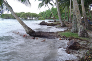
Sources
James, D. (2018, August 03). Lost at sea: The Race Against Time to Save the Carteret Islands from Climate Change. ABC.net. https://www.abc.net.au/news/2018-08-04/the-race-against-time-to-save-the-carteret-islanders/10066958.
Munoz, S. M. (2019, June 11). Understanding the Human Side of Climate Change Relocation. Resilience.org. https://www.resilience.org/stories/2019-06-11/understanding-the-human-side-of-climate-change-relocation/
Nurse, L.A., R.F. McLean, J. Agard, L.P. Briguglio, V. Duvat-Magnan, N. Pelesikoti, E. Tompkins, and A.Webb, 2014: Small islands. In: Climate Change 2014: Impacts, Adaptation, and Vulnerability. Part B: Regional Aspects. Contribution of Working Group II to the Fifth Assessment Report of the Intergovernmental Panel on Climate Change [Barros, V.R., C.B. Field, D.J. Dokken, M.D. Mastrandrea, K.J. Mach, T.E. Bilir, M. Chatterjee, K.L. Ebi, Y.O. Estrada, R.C. Genova, B. Girma, E.S. Kissel, A.N. Levy, S. MacCracken, P.R. Mastrandrea, and L.L.White (eds.)]. Cambridge University Press, Cambridge, United Kingdom and New York, NY, USA, pp. 1613-1654
Carteret islands. (2021, April 26). In Wikipedia. https://en.wikipedia.org/wiki/Carteret_Islands
Image Source: https://www.resilience.org/stories/2019-06-11/understanding-the-human-side-of-climate-change-relocation/
Garret King, Community and Economic Development, Penn State University
One of the least talked about natural disasters comes from glaciers and the dangers they pose when they melt rapidly or collapse. Recently in Raini village, a village in Uttarakhand, a glacier is believed to be responsible for a flash flood that has killed at least 50 people. The leading theory is that a 500 meter piece of glacier broke off from the main section and fell into the river, causing a flash flood. For this event one expert said she believed that the reason that this event was so powerful is because of trapped water inside the glacier that makes “sub-glacial lakes” that adds to the amount of water that is in the flash floods. The community has been devastated not only by the loss of life but also the destruction of roads and other infrastructure that exists along the river. Much of this was completely destroyed, mainly a silt filtration tunnel that provides water to the city of Delhi. In the future it is expected to become a more common occurrence as temperatures increase and increased glacial melt prevents glaciers from staying stable. With more melt it is expected that there will be more of these events where large chunks of glaciers full of water will fall into the river, causing more floods and destruction. So far there are not many solutions to prevent the melting of glaciers besides preventing climate change and currently, that seems impossible especially in the short time necessary to prevent these events. This means that the community and people living along the river need to find ways to protect themselves or change the infrastructure along the river. In the case of the silt filtration tunnel, they might have to add layers of filtration or gates to prevent it from getting clogged or damaged in future events as this tunnel provides water to larger regions and cities.
Sources
Singh, K., & Anab, M. (2021, February 14). Water in glacier was the real culprit behind flood. Msn.com.
Verma, L. (2021, February 14). Uttarakhand glacier burst: 12 more bodies recovered; toll rises to 50. Msn.com.
Sea Level Rise in Miami, Florida
Garret King, Community and Economic Development, Penn State University
The global changes that we are causing in our world stretch far beyond the pollution and destruction of the environment that we are causing. Our actions of producing energy from high carbon sources had led to the increase of atmospheric carbon that is warming our planet. This warming is melting our glaciers and ice sheets around the world and is adding to the rise in sea level. Many major cities are at risk of rising sea levels as the majority of cities around the world are built next to the ocean and hold a large majority of the world’s population. In the United States, one city that is facing an imminent crisis is the city of Miami in Florida. In Miami, the city is not only flooding when there are storms and hurricanes, but now parts of the city floods when there are strong tides (Cappucci, 2019). Stronger than usual tides called “King Tides” have caused flooding now on a repeating cycle from the sun and moon cycles. One of the biggest issues that the city is facing is the flood waters mixing with sewage and then flooding into the city (Cappucci, 2019). Flooding is pushing water into places it has not been before and that affects city infrastructure. The city will have to adapt to the changes. The now common cycle is only going to affect more and more people as the sea level rises and flooding becomes more and more common. For the city of Miami there are 85,000 residents that are living at an elevation of 3 feet or less (Cappucci, 2019). These residents are the ones that are facing the most imminent effects of the rise in sea level, and their homes are the ones that will be flooded first. The people living in the low regions of the city will have to relocate to new areas or hope that the government and local leaders will come up with ways to save them. The city currently expects that flooding will cost $5.7 billion in property by the year 2050 if nothing changes (Cappucci, 2019). The options for the city are limited, as building barriers in a city cannot block roads and social spaces and raising the land costs too much. However, Miami Beach is attempting to raise roads and install pipes. The issues do not stop with what is happening on the surface either, as sea water is also leaching into the groundwater and displacing fresh water sources. Sea water intrusion into the groundwater is entering aquifers and making it so the water cannot be used for drinking water or agricultural uses (McNoldy, 2015). The sea water is not only flooding the surface of the city, but is also flooding under the city, affecting the groundwater the city and surrounding areas depend on. We know the sea is going to continue rising and will not stop any time soon so the city, along with many others, will have to find ways to adapt or move.
Sources
Cappucci, M. (2019, August 8). Sea level rise is combining with other factors to regularly flood Miami. The Washington Post.
McNoldy, B. (2016, January 1). Water, Water, Everywhere: Sea Level Rise in Miami. United States Regulatory Commission. https://www.nrc.gov/docs/ML1601/ML16015A344.pdf
Julia Kline
Qaanaaq is a town in the country of Greenland and it is also one of the world’s northmost towns. Due to it being one of the northmost towns in the world, and the threat of climate change rearing its ugly head, the residents of Qaanaaq are more likely to lose their homes than other towns that are further south. This threat to the town of Qaanaaq’s homes – there are roughly 650 residents is Qaanaaq – arises because the town’s homes are built upon permafrost. Whenever the ground thaws and then refreezes, the thawing and freezing cycles make all the structures in Qaanaaq move up and down. With that being said, the thawing and freezing cycles of Qaanaaq’s permafrost are causing houses and structures to collapse on almost a daily basis. Thus, the residents of Qaanaaq live with the terror of threatened building collapses on an almost daily basis. In fact, due to warming climates, in 2018 Greenland experienced temperatures as high as 23 degrees Celsius (41 degrees Fahrenheit), which are record high temperatures for Greenland.
Not only do the residents of Qaanaaq fear for their homes and businesses, but Qaanaaq’s residents are also concerned for their survival and way of life. During the period of 1980 through 2008, the sea ice in the Arctic near Qaanaaq has lost more than half of its thickness. If the sea ice continues to melt, Qaanaaq’s population will have no way to hunt or fish on the sea ice, and new hunting and fishing routes will have to be made. Thus, Qaanaaq’s main source of food is rapidly disappearing given the thinning of the sea ice and the fact that imports arrive at Qaanaaq only twice a year.
This thinning sea ice at Qaanaaq also has a huge effect on the residents’ ability to access fresh water. Summer in Qaanaaq typically only lasts around 4 months, during which time fresh water can be obtained from a nearby river. However, in the long winter season, it is simply too cold for the river to flow, and the residents of Qaanaaq must again look to the sea for their survival: large dump trucks drive upon the sea ice to collect icebergs, which are taken to a facility that melts them down and distributes water to all of Qaanaaq’s residents. Thus, the thinning of the sea ice presents a real threat to Qaanaaq’s ability to access fresh water during the winter season.
Sadly, there are not many solutions to be had for the residents of Qaanaaq. As the climate change continues and temperatures climb, houses and buildings in Qaanaaq will continue to be destroyed and residents’ lives will be in danger on a daily basis. While there are potential solutions for the residents of Qaanaaq to access fresh water during the long winter, those solutions are costly. One such option would involve frequently drilling through ice over local rivers to obtain water that continues to flow deep beneath the river ice during the winter months. In addition, Qaanaaq could build more water storage tanks while the river is flowing in the summer months and fill them in anticipation of the coming winter. This would be very expensive for the small community. No matter the solution, unfortunately, Qaanaaq may not be around for much longer.
Sources
Filipova, A. (2018, November 12). The remote Arctic town that is melting away. BBC. https://www.bbc.com/future/gallery/20181109-qaanaaq-greenland-is-melting-away-from-climate-change
Kerrn-Jespersen, R. (2016, August 8). This Arctic town has running water for just four months of the year. Science Nordic. https://sciencenordic.com/denmark-greenland-science-special-society/this-arctic-town-has-running-water-for-just-four-months-of-the-year/1436270
Sea Level Rise Threatens New Orleans, Louisiana
Julia Kline
Originally, New Orleans, which is located in the State of Louisiana, was built above sea level. However, over time, New Orleans has experienced drastic changes with respect to sea levels around the city. In fact, sea levels are currently rising about two inches per year in New Orleans and, being a city surrounded by water, the city is sinking. While scientists for many years blamed the sinking of New Orleans on issues such as oil drilling and the soft sediments under the city, a recent study may have found what is truly to blame: shifting tectonic plates. Geologist Roy Dokka of Louisiana State University conducted a study of changing sea levels in New Orleans by examining the impact that the shifting of the tectonic plates had upon the city New Orleans; his study was centered around Michoud, Louisiana, a city near New Orleans which is on the southeastern shore of Lake Pontchartrain. Dokka’s study relied upon 50 years of data collected by the National Oceanic and Atmospheric Administration, which had conducted multiple surveys of the Michoud, Louisiana region beginning in 1955.
One key benchmark that Michoud noticed was a 2,000-meter-deep solid steel well in Michoud. Considering that human activities such as drilling and the natural settling of soil will only take place within the first 2,000 meters of Earth’s surface, the well could be expected to stay at the same elevation unless movements were occurring beneath the well in fault lines under the city. Examining the data and utilizing the well as a reference, Dokka determined that the shifting of tectonic plates beneath the New Orleans area was responsible for between 50 percent and 73 percent of the New Orleans area’s sinking. Soil drainage and sediment compression were responsible for the remaining percentage of the sinking of the New Orleans area. Still, it was tectonic plate movement that accounted for most of New Orleans’s change in sea level.
While Dokka’s study calls into question long held beliefs about the origins of the sinking of New Orleans, regardless of the cause of the sea level rise, New Orleans could experience as much as 14.5 inches of sea level rise by 2040 and 6.5 feet of sea level change by 2100 if action is not taken quickly. In an effort to protect the city, in 2019 and after a decade of work, the Army Corps of Engineers completed a 350-mile-long group of protections for the city that includes concrete floodwalls, pump stations and gated structures known as the Greater New Orleans Hurricane and Storm Damage Risk Reduction System. Even with the protection provided by the Greater New Orleans Hurricane and Storm Damage Risk Reduction System, the residents of New Orleans are still concerned that in the long term, these protections will not be enough to save New Orleans and many question whether the System should have been built to higher standards to prepare for the massive sea level change that the city will likely experience in the future. Unfortunately, there has not been a total solution found to completely protect New Orleans in the long term.
Sources
Frank, T., & E&E News. (2019, April 11). After a $14-Billion Upgrade, New Orleans’ Levees Are Sinking. Scientific American. https://www.scientificamerican.com/article/after-a-14-billion-upgrade-new-orleans-levees-are-sinking/
Why Is New Orleans Sinking? (2006, March 28). Science. https://www.sciencemag.org/news/2006/03/why-new-orleans-sinking
Alexandra Kovacs
50 miles off the coast of Bangladesh and India lies an island called Kutubdia which people are fleeing due to the consistent rising tides of the Bay of Bengal. The island has lost half of its size in 20 years, it is now 100 sq km. It is one of what they call the “vanishing islands” for how drastically they are being reclaimed by the water. 40,000 people have fled the island since 1991. It is expected that the remaining 80,000 residents of the island will end up migrating to the mainland. Many residents of the island have been temporarily welcomed onto the mainland to fend for themselves on the beaches, building huts out of the nearby flora, but three years later, the government is ready for them to move on. These people like to refer to themselves as “climate refugees.” They have slowly watched as their houses, churches, schools, and other buildings have been lost to the ocean, and now do not know where to go. They have tried to move to higher parts of the island, but the water just keeps rising. They have no money and no sense of direction of what to do next. A local fisherman named Jakir Hossain said, “We know the end is coming.” It is estimated that Kutubdia will be completely lost within the next thirty years. Many other islands in the area will also be lost. Bangladeshi government estimates over 4 million people are at real risk to lose their island homes within the next 8 years.
Scientists believe that a combination of manmade and natural events are the root of the problem. One problem is land erosion, which has always been a problem in the Bay of Bengal, but the rate is rapidly increasing. Another is sea surface temperatures have risen, which leads to an expansion of water in the bay. Also, climate change is the likely cause of the harsher and longer storms that have come to the area in recent years, which bring in more water to the bay from the sea and some of the rivers in the area. Monitoring of sea level has been done in an area around Kutubdia and has seen an increase of around 8mm a year for the past 20 years. There is no immediate solution to the problem. We can only set up programs to try and help all of the migrants that are going to be needing to find somewhere new to go. Many homes are going to be lost, and millions of people will be displaced before the world will be able to hopefully get a hold on the rising sea level. Until then, many islands and cities will be reclaimed by the ocean.
Sources
Vidal, J. (2013, January 29). Sea Change: the Bay of Bengal’s Vanishing Islands. The Guardian. www.theguardian.com/.
Alexandra Kovacs
Akiak, Alaska, a city of 340 residents, was shocked to discover that 75-100 feet of their riverbank suddenly disappeared over the course of a few hours, making the Kuskokwim River much closer to their homes. So far, three houses are in danger of being overcome by the river. The riverbank along the entire city has now been lost. Scientists attribute this drastic event to melting of the state’s ice and permafrost and a warm winter and spring. It is believed that the city could soon turn into an island. Many roads and buildings are constantly being destabilized due to the melting of the permafrost. It is believed Alaska is warming at twice the rate as the rest of the US, and in 2019, Alaska had its warmest spring on record. Spring in Alaska has heated 2.2 degrees Celsius since the 1970’s. Other problems facing the Alaskan communities from the rising heat is the melting of the sea ice which previously protected the coastal communities from storms. This not only affects the human residents but the plant and animal life as well, which in turn also affects food sources for residents.
The only solution as of right now is stay and fortify or relocate. The government has identified dozens of villages that most likely need to be relocated and some have received the funds to do so. Other communities are not so lucky to receive government help yet, and they must decide what their options are. Not only is permafrost melting a problem because it is destabilizing buildings and roads in the communities in Alaska, but it releases large amounts of methane while it melts into the atmosphere. Scientists believe that this could accelerate the global heating we are already causing. Not only is this just a problem for Alaska, but if the permafrost has this much impact, this needs to be a concern for the whole world.
Sources
Milman, O. (2019, June 17). Thawing Alaskan Permafrost Threatens Local Communities. Grist. grist.org/
Alyssa Martin, Advertizing/Public Relations, Bellisario College of Communications
The area that I have chosen to talk about for this assignment is a small village in Newtok, Alaska. The village consists of only 380 people who are already experiencing the threat of ice melting. For this Yup’ik village that is positioned on the Ninglick river and a short distance from the Bering Sea, the threat of ice melting has really become a reality.
Since they are surrounded by bodies of water, they are vulnerable to and suffering from thawing permafrost and erosion. The people of the Yup’ik village are being forced to move due to increased flooding from melting ice. Their land is quite literally being eaten away by rising sea levels, melting ice, and storm surges all as a result of climate change. They have experienced things such as buildings and homes collapsing and sinking and landfills being whisked away.
The forecasted impacts would be more destruction and more land being swallowed by the sea. It has been predicted that in the next 6 years, major quantities of the town will become part of the river (as more and more soil and land collapses into the water). Another issue for these people is that their hunting grounds are being depleted. Animals are on the move, therefore their food supply keeps growing smaller. As terrible as this is, the village knew this was coming and has been planning the move for years.
The big move to higher ground is the solution for this village. Congress aided the Yup’ik village in constructing a new place to live with proper facilities, including a water treatment plant, homes, and school teachers – in exchange for the rest of the Newtok land to be a part of the Yukon Delta National Wildlife Refuge. While it is no easy task to leave behind your home, the villagers seem to understand that this option is a great deal safer than where they currently reside.
Sources
Welch, C. (2019, October 22). Climate change has finally caught up to this Alaska village. National Geographic. https://www.nationalgeographic.com/science/2019/10/climate-change-finally-caught-up-to-this-alaska-village/#close
Sea Level Rise in Delray Beach
Alyssa Martin, Advertizing/Public Relations, Bellisario College of Communications
For the topic of sea-level rise, I will be talking about a city in Florida called Delray Beach. The city of Delray is home to about 65,000 people, and it’s vulnerable because at its lower parts, it sits just above sea level (six feet above, to be exact). When asked about the rise in sea-level in Delray, a resident recalled that years ago, his yard would become slightly flooded, but only when there was a severe storm. Now, he says, it is a regular occurrence and happens almost every high-tide, no storms needed. Other residents in Delray have the same problem, and some have it even worse, as the flooding even reaches all the way to their doorsteps.
Delray is North of Miami Beach, about an hour away. Miami is even more vulnerable to sea-level rise because much of the city is barely above sea-level. However, Miami Beach is spending a whopping 500 million dollars over the course of a few years in order to install the necessary defenses to protect the city from coastal flooding due to rising sea-level and other climate issues. These defenses include pumping stations, improved stormwater drainage, and even raising roads. While this is good to hear for the residents of Miami, smaller cities and towns throughout Florida don’t have as much funding and have smaller tax bases to dip into, which means they may not have even close to the same amount of protection.
The forecasted impacts on the community of Delray do not look too optimistic, without the proper funding. By 2100, sea-level is predicted to rise up to six feet, meaning much of Delray could be underwater, if not all of it. Therefore, with this information, it is common sense that Delray needs to act fast, because there will come a time when the possible defenses and protection may not work. Delray joined the Palm Beach County Coastal Resilience Partnership, which is an alliance funded by a grant from the Florida Department of Environmental Protection which allows cities to share their resources and further discuss solutions to their climate vulnerabilities. Those who participate in the Partnership are confident that if Delray can budget reasonably and work together to potentially get a significant amount of federal financial aid, they may be able to afford the resources they need to -literally- stay above water.
Sources
Kann, D. (2019, September 3). Other cities have built levees and sea walls. That won’t work in Florida. CNN. https://www.cnn.com/2019/09/01/us/sea-level-rise-costs-climate-change-florida/index.html
Loss of Sea Ice in Kivalina, Alaska
Kayla McCauley, Meteorology and Atmospheric Science, Pennsylvania State University
The small village of Kivalina, Alaska sits on an island off of the coast of the mainland. The village is home to native Inupiant residents, whose ancestors had always relied on sea ice for protection and livelihood. Residents of Kivalina rely on sea ice as protection from the harsh sea and live off of animals from the ice such as whales, seals, and fish. However, the melting of sea ice is threatening the existence of Kivalina, as the shoreline is quickly dissipating with rising sea levels. In the past decade, the yearly ice surrounding the island has continuously diminished. It is expected that by 2025, Kivalina will no longer exist (Scuri, 2020). Along with the impending threat of rising sea levels, the lack of year-round sea ice has hindered the residents’ livelihoods which depend on hunting and fishing on the ice to survive.
For years, there have been attempts to assimilate the residents into the mainland, however, they have continued to live their way of life as their ancestors once did (Scuri, 2020). This small community is extremely vulnerable as they have no protection against rising sea levels, and they are at risk of losing their way of life that has been sustained for generations (Taylor, 2019). Most in the village live off of the ice, and without it, their lives cannot continue as they have. This risks their livelihoods and their entire culture.
With the diminishing sea ice and rising waters, the residents of Kivalina are going to be forced to relocate and, in turn, lose everything. In 2019, a road was built to connect the village to the mainline so there would be an escape route when waters impede (Taylor, 2019). Unfortunately, with the quickly impeding sea levels, there is not a solution that will prevent the 2025 fate of Kivalina. Although this is true for Kivalina, there are other towns and populations who will have the same fate if action is not taken to reverse greenhouse gas emissions. For many, there is still time. If emissions continue on the current path, many villages and towns will suffer the same losses as Kivalina. This means losses of livelihoods and cultures and increasing numbers of climate refugees worldwide.
Sources
Scuri, E. (2020, January 6). Kivalina, Photos of the Alaskan Village That Could Be Gone by 2025. LifeGate. https://www.lifegate.com/kivalina-alaska-photos.
Taylor, A. (2019, September 18). Photos: The Impact of Climate Change on Kivalina, Alaska. The Atlantic. https://www.theatlantic.com/photo/2019/09/photos-impacts-climate-change-kivalina-alaska/598282/.
Rising Sea Levels in Guet Ndar, Senegal
Kayla McCauley, Meteorology and Atmospheric Science, Pennsylvania State University
Guet Ndar, a fishing district within Saint Louis, Senegal, faces the threat of rising sea levels. The district has already lost considerable land, with buildings and developments already under water (Rosman, 2019). The district, as well as the whole city, is sinking and is at risk of becoming fully submerged. Every year, the sea level rises 5 meters, putting Guet Ndar in immediate danger (Lawal, 2021). Rows of houses in the district have been taken out by flooding events in recent years, already leaving climate refugees behind. This community is extremely vulnerable because it is an impoverished area. Vulnerability from climate is dependent on economic vulnerability coupled with environmental vulnerability. A district such as Guet Ndar suffers both.
The shifting waters have also caused migration of fishing routes, reducing the amount of fish that is available off of the Senegalese shore (Lawal, 2021). This is detrimental to the economy and livelihood of Guet Ndar, which depends on fishing. As global temperatures continue to rise, Guet Ndar is at risk of being swallowed completely by the sea, forcing the 30,000 residents of the district to relocate (Rosman, 2019). It is predicted that by 2080, 80% of Saint Louis will be underwater, with the fishing district of Guet Ndar the first at risk (Pronczuk, 2020). In 2015, a neighboring fishing district, Doune Baba Dieye, became fully submerged by the sea (Lawal, 2021). Guet Ndar is at risk of the same fate.
After the flooding of Doune Baba Dieye, Senegal has opted for sea walls over long term solutions in order to protect Guet Ndar (Lawal, 2021). However, these short term solutions are not expected to be able to keep up with impending rises of sea levels and accompanying floods. The most effective way to protect the district would be artificial reefs off of the coast so that the waves will break on the shore (Lawal, 2021). Yet, it is unlikely these long term measurements are taken by the government over the short term solutions. Ultimately, the residents of Guet Ndar will continue to face severe risks to their home and livelihoods.
Sources
Lawal, S. (2021, February 3). Swallowed by the Sea: Senegal’s Historic Slave Port Teeters on the Edge of Environmental Disaster. The Telegraph. https://www.telegraph.co.uk/global-health/climate-and-people/swallowed-sea-senegals-historic-slave-port-teeters-edge-environmental/.
Pronczuk, M. (2020, January 8). How the ‘Venice of Africa’ Is Losing Its Battle against the Rising Ocean. The Guardian. http://www.theguardian.com/environment/2020/jan/28/how-the-venice-of-africa-is losing-its-battle-against-the-rising-ocean.
Rosman, R. (2019, June 13). Climate Change Has Already Displaced Hundreds In Senegalese City Of Saint-Louis. NPR. https://www.npr.org/2019/06/13/732480669/climate-change-has-already-displaced-hundreds-in-senegalese-city-of-saint-louis.
Thinning Sea Ice in Barrow, Alaska
Brett Miller
Sea ice melting and thinning, coastal storms that strike the northern Alaska boundary, flooding, and various habitat changes due to warmer ocean and air temperatures are all threats to BarrowAlaska. This Barrow culture is at risk because of their unique way of life. Residents of Barrow rely on hunting, fishing, and collecting for food (as opposed to widespread farming). Local animals are extremely vulnerable to ecosystem and climate change, and given Barrow’s proximity to the ocean, there is nowhere for them to move northward. This place, for example, has a lot of polar bears in the region, and there’s a lot of sea ice melting and thinning due to climate change effects being about 2 times more extreme in the Arctic. Food scarcity can lead to lower fertility rates in polar bears. If the population of keystone species like the polar bear declines dramatically in the future, it could have drastic consequences for the local environment and its services. Summer sea ice area has decreased by 40% from 1978 to 2007, and this trend is expected to continue, which could cause property damages as the sea pushes inland. Furthermore, human populations have indicated that finding and storing food has become more difficult. Since sea levels are expected to rise by up to 10 feet over high tide levels by 2100, this region could be inundated to the tune of 40%. Furthermore, rising sea levels and high tides cause significant erosion on river banks, resulting in a build-up of sand and silt in the rivers, making it difficult for local residents to acquire the same amount of food. It has been observed that fish species from warmer waters are appearing in fishing nets, as well as other beetle species and a rapid increase in fly numbers. These flies are known to make Caribou sick, which in turn harms the people in the area because Caribou is a source of food for these people. As stated in the previous entry, it is extremely difficult for a community to slow sea-level rise and stop the rising temperatures. Alaska’s climate target, to reach net-zero carbon emissions by 2040, was a significant move toward a solution. They want to achieve this aim by reducing airline fuel consumption and developing alternative fuels, as well as using advanced carbon removal/capture devices to offset their emissions. Another option for maintaining a healthy local environment is to impose fines on those who kill endangered wildlife. Since wildlife’s land area is diminishing as coastal erosion worsens, sea levels rise, and ice sheets melt, delegating additional land area to wildlife is an option to consider. Another possibility would be the implementation of sand dunes in between residential areas and ocean to slow storm surges that have closed roads in the past. Finally, plans to build a deep channel that will allow for easier imports and exports, as well as local boating for hunting, will help lower the cost of local goods like milk, which is currently $11 per gallon, and make hunting/fishing more available.
Sources
Alaska Airlines. (2021, April 21). Flying with purpose: Alaska sets new climate goals, including net-zero carbon emissions by 2040.
National Weather Service Alaska Region. (2013, September 6). In Barrow, Alaska, climate change in action. Climate.gov. https://www.climate.gov/news-features/understanding-climate/barrow-alaska-climate-change-action
Reiss, B. (2010, March). Barrow, Alaska: Ground Zero for Climate Change. Smithsonian Magazine. https://www.smithsonianmag.com/science-nature/barrow-alaska-ground-zero-for-climate-change-7553696/
Sea Level Rise Viewer. (n.d.). NOAA. https://coast.noaa.gov/slr/#/layer/sce/1/-10018475.872667633/3405317.254875168/12/satellite/40/0.8/2050/interHigh/midAccretion
Amanda Monahan, Biology, Penn State University
Due to climate change, permafrost in Nome, Alaska is melting at an alarmingly fast rate. Over 91% of Nome’s permafrost “ponds” have shrunk significantly in the past 25 years (Climate Hot Map Team, n.d.). The melting of permafrost has a massive effect on the land contained in it and around it. Melting decreases surface area and makes the ground softer. These two effects have been wreaking havoc on manmade structures all around Alaska, especially in Nome. Bridges have been tilted, houses have been shrinking into the ground, and highways have been crumbling. By 2030, this permafrost melting is expected to cost between $3.6 and $6.1 billion dollars (Climate Hot Map Team, n.d.)! These costs exclude privately owned property.
Nome, Alaska is especially vulnerable to this melting as it is a subarctic climate and has relatively thin layers of permafrost because of this. These thin layers of permafrost are especially susceptible to thawing.. The state of Alaska is also warming at about twice the speed of the entire United States, which contributes greatly to the rapid rate of this permafrost thawing. It is predicted that Nome’s permafrost will continue to melt, costing the city up to $13.7 billion in repairs of public infrastructure. The melting of permafrost also releases large amounts of carbon dioxide and methane that will contribute to our ongoing climate crisis.
Unfortunately, there is no easy solution to the problem in Nome. All of us, however, have the power to help Nome by watching our carbon footprint. Governmental actions (i.e. limiting the burning of fossil fuels, providing money for green programs, etc.) can also help slow climate change, which will in turn reduce the rate of warming in Alaska, and slow the melting of permafrost. The city of Nome can also begin to make adjustments to public infrastructure, and mandate that all new structures (public or private) be built with the notion of permafrost melting in mind. However, ultimately, the residents will have to move to higher ground.
Sources
Climate Hot Map Team. 2011 Climate Hot Maps: Global Warming Effects Around the World. (n.d.). Climate Hot Map. Union of Concerned Scientists. www.climatehotmap.org/global-warming-locations/nome-ak-usa.html.
Autumn Morris
Climate change comes in all different forms and often greatly affects poorer and more isolated communities than those with the resources to combat the consequences. Climate change can be inconspicuous in many regions around the globe, but for the Alaskan village of Shishmaref and its 600 residents, the effects of rising temperatures have noticeably altered the small community within just a few decades. As temperatures continually rise, annual sea ice that has protected Shishmaref shores is now melting at unprecedented rates (Sutter, 2017). The island of Sarichef is located just below the Arctic circle, the fastest-warming region on earth. Temperature rise unequally affects northern regions, which is altering normal climate patterns for Shishmaref. Prolonged warm temperatures are diminishing the sea ice faster each year (Joyce, 2014). The ice is used to cushion the island from the sea and large storms, but now, as the sea ice forms later and melts sooner, strong waves and storms ravage the shores, taking the soil with it. In a period of just 9 years, Shishmaref lost land at a rate of over 7ft/year (Sutter, 2017). Overall, since 1980, the entire island has lost about 3,000 feet of land, and as the land erodes, so does the residents’ hope about the future for Shishmaref (Visser, 2016). The ancestors of the residents took into consideration the changing sea ice; they migrated with the seasons, moving inland when the seasons changed. They knew that the island was no place to live due to battering waves; living there year-round was never the plan. This changed when the United States government colonized the island. The original residents were forced to make a permanent settlement on eroding land because it was where the government built schools. These schools were mandatory for children to attend, and the government threatened to revoke custody if parents did not comply. To add insult to injury, the permafrost under the island has begun melting, which will have detrimental effects on the already depleting land (Mott, 2018). The community is unable to relocate without government assistance, and the U.S government has yet to react to the pleas of the residents for moving off the island. To make matters worse, the island is isolated from the mainland, only reachable by land transport in the deep winter when the ice is thick, but as temperatures warm, this ice is becoming increasingly thin (Visser, 2016).
Unless aid is received, the land will continually erode and leave the residents with less and less space, soon washing away the entire community. Residents have had their homes lost to the sea over the past decades as violent storms have made their way to the tiny island. A seawall built by U.S Army engineers surrounds the island. It was put in place after a major storm in 2005, which knocked out a dozen homes. The loss of land is mind-blowing, and it will continue leaving the residents homeless (Motts, 2018).
Temporary solutions include building a stronger seawall, which could stave off the island disappearing for a few more decades possibly. The problem is that the island is so small, with a population of less than 1,000, and creating expensive drainage systems and walls for an island that will become non-existent may be a bad investment. Relocation seems like the most permanent solution as the island will inevitably vanish. Storms rage against the island, the sea will continue to rise, and the ice and permafrost will continue to melt, so moving off Sarichef is the best way to ensure the residents’ safety (Muggah, 2019).
Sources
Joyce, C. (2014, December 18). Arctic is Warming twice as fast as world average. NPR. https://www.npr.org/2014/12/18/371438087/arctic-is-warming-twice-as-fast-as-world-average
Mott, N. (2018, October 22). An Alaskan village is falling into the sea. Washington is looking the other way. The World. https://www.pri.org/stories/2018-10-22/alaskan-village-falling-sea-washington-looking-other-wAy
Muggah, R. (2019, Jan 16). The world’s coastal cities are going under. World Economic Forum. https://www.weforum.org/agenda/2019/01/the-world-s-coastal-cities-are-going-under-here-is-how-some-are-fighting-back/
Sutter, J. (2017, March 29). Tragedy of a village built on ice. CNN. https://www.cnn.com/2017/03/29/us/sutter-shishmaref-esau-tragedy/index.html
Visser, S. (2016, August 18). Alaskan village votes to relocate over global warming. CNN. https://www.cnn.com/2016/08/18/us/alaskan-town-votes-to-move/
Sea Level Rise – Charleston, SC
Ryan Mutter
Charleston, South Carolina is on the East Coast of the United States, just north of Georgia. The community of Charleston has been dealing with flooding for a very long time since it is a coastal city with low elevation, but in recent years, flooding has significantly increased due to polar cap melting and sea level rise. It is estimated that South Carolina’s coast has decreased by 10 inches since 1950 because of encroaching seas. On average, Charleston used to deal with 2 flood days per year, but flooding has increased by nearly 75% since the year 2000. Recent predictions estimate a potential 180 days of flooding by the year 2045 (South Carolina’s…, n.d.)
The community of Charleston is at risk because of its lack of elevation that continues to worsen due to land subsidence. Charleston is not only dealing with a rising sea level but is dealing with land that is sinking from over pumping of aquifers and heavy construction. Charleston is also at risk of something called King Tides. These tides are unusually large and typically occur on full moons or when the sun, moon, and earth align. Due to an already increasing sea level, king tides add to the risk and create even more flooding in the coastal community of Charleston (South Carolina’s…, n.d.).
The sea level rise of South Carolina and more specifically of Charleston does not show any signs of slowing down. In fact, the future forecast predicts a continued rise of 1 inch every 2 years. To put into perspective, in the past, it took Charleston 26 years to rise just 6 inches. The speed of this rise is now set to double in rate, rising 6 inches in just 13 years. There is a lot of uncertainty since we do not know exactly how much the climate will continue to warm and how fast the ice caps will melt (South Carolina’s…, n.d.).
So, what are the plans for Charleston? The community of Charleston is implementing more strict guidelines for elevation standards during new construction. These guidelines call for a 1.5-2 feet to 2-3 feet rise of foundations of new constructed hospitals and medical facilities. The community of Charleston also plans to install improved drainage systems, raise the elevation of main streets, and retrofit public housing. These projects are projected to cost 154 million dollars. Luckily, the city is being aided by the Regional Coastal Resilience Grant from NOAA’s Office for Coastal Management (Charleston Again…, n.d.).
Sources
Charleston Again Turns to NOAA for Sea Level Rise Guidance. (n.d.). Office For Coastal Management. https://coast.noaa.gov/states/stories/charleston-sea-level-rise-strategy.html
South Carolina’s Sea Level Is Rising And It’s Costing Over $2 Billion. (n.d.). SeaLevelRise.org. https://sealevelrise.org/states/south-carolina/#:~:text=The%20sea%20level%20around%20Charleston,1%20inch%20every%202%20years.
Sea Level Rise in Kivalina, Alaska
Eric Myskowski, Meteorology, College of Earth and Mineral Science
One of the hardest hit communities by sea level rise is Kivalina, Alaska. It is one of many Native American Villages scattered on the west coast of Alaska, situated right on the Bering Sea. It, like the rest of the villages, is extremely vulnerable to sea level rise. It is geographically situated on a narrow barrier island parallel to the coast, making it vulnerable to flooding.
The first issue is sea level rise itself. The town has an elevation of 8 feet. This means that any sea level rise greater than 2 meters will completely inundate the town. However, that is only the beginning of the village’s problems. The Bering Sea is famous for its winter storms, with centers of low pressure commonly below those of moderate hurricanes. This means that this community has to deal with strong storm surges and waves every winter. These have slowly been eroding the island and lowering it, making it more and more vulnerable to sea level rise and the next big storms.
Another major issue though is the lack of winter sea ice. Typically, by the time many of these major storms occur in the winter, the Bering Sea has frozen over. This means that there is no storm surge or waves because the sea is protected from the strong winds. However, due to climate change, the sea is freezing over much later, if it all at this location. This is opening up the whole winter for destruction from these major storms and this is a situation that will only get worse as the climate warms more. On top of that, Alaska is one of the parts of the planet that is warming fastest due to global warming, a trend that is expected to continue.
There are several solutions that are being brought up for the problem. The first is building sturdier homes and defenses. The town is trying to strengthen the shoreline with large rocks and concrete, attempting to prevent the storms from eroding it out. However, the most likely scenario is abandonment. There are projections that this peninsula will be completely destroyed by the end of the decade, and plans are already in place to move all the residents. The plight of this village is not limited to it however. Many of the Native American villages along the Alaska coast will probably be in the same situation as the century progresses.
Sources
Toomey, D. (2016, June 23). Unable to Endure Rising Seas, Alaskan Villages Stuck in Limbo. Yale Environment 360. https://e360.yale.edu/features/sea_level_rise_alaska_native_newtok_shishmaref_kivalina
Robinson, M. (2017, September 27). This remote Alaskan village could disappear under water within 10 years – here’s what life is like there. Business Insider. https://www.businessinsider.com/what-life-is-like-in kivalina-alaska-2017-9
Changing Oceans in Point Hope, Alaska
Megan Neely
Point Hope, located on the northwestern coast of Alaska, is a community of Iñupiat Eskimo (Point Hope, n.d.). Currently, the community is facing serious ice melting as a result of increased temperatures (Sea Ice, n.d.). From February to August 2019, Alaska as a whole faced record high temperatures which caused extreme ice melting. “By August, the ice had retreated over 150 miles from Alaska’s coast” (Lydon, 2020). Considering Point Hope is on the coast, this is significant. The melting primarily affects arctic marine life like polar bears or seals. In addition to the melting ice, with the increase in carbon dioxide emissions, the oceans are becoming more acidic, killing marine life like Phytoplankton (Oceans, n.d.). The melting ice and acidification makes it harder for animals to find food; in turn, it is harder for the Iñupiat Eskimo to find food. The community’s primary food source is marine life: “seals, bowhead whales, beluga whales, caribou, polar bears, birds, (and) fish…” (Point Hope, n.d.) many of which are endangered. In particular, the bowhead whale is at the center of Iñupiat culture and the backbone of the economy. Nalukataq, a yearly festival, celebrates a “successful whaling season” (VOA News, 2018). Many of the economic goods the community makes are “whalebone masks, baleen baskets, (and) ivory carvings…” (Point Hope, n.d.). With hunting quotas already in place since the 1970s, the decline of marine life population may mean an end to the cultural practice and a drastic economic shift (VOA News, 2018). The temperatures are projected to continue to rise especially in northern areas of Alaska. Because the melting is caused by globally increasing temperatures, there is only so much that can be done. The immediate concern for Point Hope would be to conserve marine life to preserve their culture and their food source. Organizations like the Alaskan Conservation Foundation are trying to limit commercial and industrial shipping and fishing in the area to help indigenous groups like the Iñupiat. In addition, they work to limit oil fracking in the area (Oceans, n.d.).
Sources
Lydon, T. (2020, July 16). Four Ways Alaska’s Unending Warming Impacts Everyone. The Revelator. therevelator.org/alaska-warming-impacts-everyone/.
Oceans. (n.d.). Alaska Conservation Foundation. https://alaskaconservation.org/protecting-alaska/priorities/protecting-lands-waters/oceans/
Point Hope. (n.d.). Maniilaq Association. www.maniilaq.org/northwest-alaska/point-hope/.
Sea Ice. (n.d.). National Parks Service. www.nps.gov/subjects/aknatureandscience/seaice.htm.
VOA News. (2018, November 3). Whales Revered as Center of Alaska Iñupiat Life. [Video] Youtube. www.youtube.com/watch?v=HvtjOEOyqw0.
Jacqueline Nehme
The community that I will be focusing on is Ittoqqortoormiit, Greenland. It is a village pretty much isolated from the rest of Greenland, with the closest town sitting 500+ miles away. The village is so small and intimate that a ship will come by two times per year to supply them with necessary supplies, but other than that they don’t have any airports or roads. Nine out of the twelve months in a year, the only way in is by helicopter.
The threat that this village is facing is that the ice that surrounds it for nine out of twelve months is ultimately freezing later and melting sooner, making these imperative months shorter. The extreme shifts in climate change that have taken place in the past few years have caused the change in ice. The ice is imperative to the village because most of the people that live on it work, travel, or hunt on the ice. It is used as a big source of food because there is little to no agriculture or plants to eat. The community is vulnerable because the ice freezing later and melting sooner is forcing people who were hunters to find other work. Teenagers who planned to work in these jobs are forced to leave the village to search for work elsewhere.
The forecasted impacts on the community are that while the climate continues to warm and the ice continues to melt, their situation will continue to worsen in this village. Polar bears are experiencing negative impacts due to the ice and are forced to migrate where the ice is not melting. With that being said, they are starting to move into the village more than the people can handle, are having more human encounters, and are staying longer, making it harder for the people to find food. The village must stay within the quota of thirty-five polar bears to kill per year which will continue to go down in number over the years for this village if the extinction of polar bears keeps spiraling down at the rate it is. Not to forget, their forecasted extinction is due to climate change.
While this very intimate village realizes they cannot fight climate change all on their own, they do recognize that it is the foundation of their issue. The solution they formed to try and start somewhere was setting up a polar bear patrol to control the polar bear and human encounters that were happening. By implementing this patrol, it will lessen the number of killings of polar bears which will hopefully help slow down the extinction of them. Controlling and slowing down the extinction process is important to the people of this village because polarbears are one of their few sources of food.
Sources
Forrest, S. (2019). Edge of the world. World Wildlife. https://www.worldwildlife.org/magazine/issues/summer-2019/articles/edge-of-the-world
Communities coping with climate change. (2019, September 26). The Guardian. https://www.theguardian.com/environment/gallery/2019/sep/26/communities-coping-with-climate-change-in-pictures
Rising Sea Level in Kiribati, Fiji
Sophie Newlin
Kiribati is a group of 33 islands located between Hawaii and Australia that sit only six feet above sea level, which means that the rising sea level due to climate change will be catastrophic to these communities, which hold 100,000 plus people. The islands sit on a system of atolls and coral reefs. It is said that Kiribati will be the first country decimated by climate change. As glaciers and ice sheets melt from the rising temperature of the earth, it is predicted Kiribati will be completely uninhabited. Two of Kiribati’s islands (uninhabited) have already been submerged due to rising sea level (Kiribati, n.d.). Not only is the sea level rise threatening Kiribati, but the area is a prime location for major storms, which are also getting more destructive due to climate change. The communities are reliant on water for food and crops, but have a small freshwater supply. Storms have already caused freshwater supplies to become contaminated. Climate change can also increase vector-borne and water-borne diseases. The coral reefs around Kiribati are also in danger from acidification (Climate Change…, 2021).
The president of Kiribati, Anote Tong, has been traveling the world advocating for policies and regulations to control the mass amounts of emissions major countries are emitting. He has seen little success, and some members of the community have already started to relocate. Currently, temporary solutions to save Kiribati have been created, such as building walls out of coral (which unfortunately has not worked). Some towns have also moved inward to place some distance between the shore and the residential areas. To prevent soil erosion, mangrove trees have been planted as well. A long-term solution was the islands buying land, 5000 acres, in Fiji to relocate to if need be (Law, 2019). New Zealand has allowed 75 people per year to move from Kiribati to NZ (Kiribati, n.d.).
Sources
Climate Change: Global Sea Level. (2021, January 5). NOAA Climate.gov. www.climate.gov/news-features/understanding-climate/climate-change-global-sea-level#:~:text=Based%20on%20their%20new%20scenarios,above%202000%20levels%20by%202100.
Kiribati, the First Country Rising Sea Levels Will Swallow up as a Result of Climate Change. (n.d.). Iberdrola. www.iberdrola.com/environment/kiribati-climate-change#:~:text=Kiribati%2C%20the%20first%20country%20rising,for%20islands%20and%20coastal%20regions.
Law, T. (2019, September 30). These Six Places Will Face Extreme Climate Change Threats. Time. time.com/5687470/cities-countries-most-affected-by-climate-change/.
Permafrost Thawing in Newtok, Alaska
Sophie Newlin
Newtok, Alaska is a small village located on the Ningliq River, and it has already been hit hard by climate change. Temperatures in Alaska are skyrocketing faster than every U.S. state (Wang, 2020). Warming of the area has caused permafrost thawing, vulnerability to floods, and erosion, which are great threats to the people of Newtok. Permafrost thawing causes severe damage to communities up north by damaging underground infrastructure like pipes, roads, and building foundations. It also releases greenhouse gases as it thaws, speeding up the warming of the planet. In addition, sea ice is melting, causing the sea level to rise and erode at banks, making the community extremely vulnerable to flooding. A study done in the early 2000s states that the majority of the town will become part of the Ningliq by 2027 (Welch, 2021).
As their only option to save their community, the Newtok people have been preparing for the last 20 years to relocate to higher ground. Because Newtok is at such high risk, agencies have not wanted to invest in infrastructure for the town, so they have lived for decades without running water or plumbing, causing health problems due to lack of sanitation. In 2019, 18 families moved from Newtok to the newly built village of Mertarvik. Mertarvik was given to the community by the government in 2003, and in return, the Newtok people gave up their land to the Yukon Delta National Wildlife Refuge. Slowly, Mertarvik is being built, but the families in Newtok don’t have much more time. In 2019, only about 20 of 60 homes were built, and there was no sewage or plumbing system, but there was electricity, its own power plant, water facility and landing-strip airport (Wang, 2020 & Welch, 2021). Despite the move, other villages in Alaska are just as vulnerable. “It’s not just one village. It’s in all the villages,” said Robert Pitka, Toksook Bay’s tribal administrator, south of Newtok (Wang, 2020).
Sources
Wang, H. L. (2020, February 10). Climate Change Complicates Counting Some Alaska Native Villages For Census. NPR. www.npr.org/2020/02/10/802218309/climate-change-complicates-counting-some-alaska-native-villages-for-census.
Welch, C. (2021, February 10). For This Alaska Village, Time Has Finally Run Out. National Geographic. www.nationalgeographic.com/science/article/climate-change-finally-caught-up-to-this-alaska-village.
Sophie Newlin
The Yamal Peninsula, Russia is an area of great wilderness that often goes unnoticed, but it is facing great changes to its climate that are already affecting the people and wildlife that reside there. Along a 435 mile long stretch with lakes and tundra connected to the Arctic ocean, the Yamal Peninsula’s indigenous people, the Nenets, migrate north during the summer and south during the summer. They cross the usually frozen Ob river in November for their winter pilgrimage to Nadym. In 2008, due to rising temperatures, the ice was not hardened enough for the Nenets to cross, which delayed their pilgrimage until late December. The Nenets rely on reindeer to pull their sleds during the migration, and with the snow melting faster and earlier than ever, the reindeer are unable to (Harding, 2009). In 2013, the winter brought warm temperatures that melted the ice, and then froze over, preventing the reindeer from grazing. This incident resulted in the death of tens of thousands of reindeer (Moss & Morton, 2020). In 2008, half of a lake the Nenets usually visited during the summer had disappeared due to a landslide caused by the melting permafrost (Harding, 2009). Russia is warming 2.5 times faster than other parts of the world, and if the global temperature rises just 4 degrees centigrade, Russia’s Arctic zones will become swampy mush (Newlin & Conley, 2021). Not only are Nenets and their reindeer being affected by the rising temperatures, so are polar bears that live much farther north. The polar bears have started migrating south to find food (Harding, 2009).
Unfortunately, Russian scientists are extremely skeptical of the existence of climate change, despite data clearly showing it. Some who see that it is happening think it is a positive change, as it creates more area for oil and gas exploration and lengthens the short growing season for crops. Alexander Chikmaryov, a Yamal native who runs a weather station, also believes climate change is ‘rubbish’ and ‘invented,’ despite his statistics showing otherwise. His data shows the ice has had a 47 cm decrease from 2008 to 2009. Chikmaryov’s data also shows the 10 degree C increase in winter temperatures from 1914 to 2009 (Harding, 2009). Putin has acknowledged climate change just once in 2019, but later backtracked and expressed doubt. Russia did sign on to the Paris agreement, but used 1990 as its target emissions level, when it was 2.4 billion tons of carbon. Currently, Russia is releasing 1.5 billion tons, so emissions will steadily increase for the next decade (Elagina, 2020).
Sources
Elagina, D. (2020, November 10). Russia: Carbon Dioxide Emissions 1985-2019. Statista. www.statista.com/statistics/449817/co2-emissions-russia/.
Harding, L. (2009, October 20). Climate Change in Russia’s Arctic Tundra: ‘Our Reindeer Go Hungry. There Isn’t Enough Pasture’. The Guardian. www.theguardian.com/environment/2009/oct/20/arctic-tundra.
Moss, T. & Morton, C. (2020, July 21). 18 Destinations Impacted By Climate Change. Condé Nast Traveler. www.cntraveler.com/gallery/10-places-to-visit-before-theyre-lost-to-climate-change.
Newlin, C. & Conley, H. A. (2021, April 22). Climate Change Will Reshape Russia. Center for Strategic and International Studies. www.csis.org/analysis/climate-change-will-reshape-russia.
Chris Nicola, Civil Engineering, Penn State University Park
Sea level rise is a major concern today, for climate change continues to worsen due to the underlying effects of extensive global emissions. It is approximated that global mean sea level has risen 8 to 9 inches since 1880 (Lindsey, 2021). Melting of glaciers and the expansion of seawater through warming are the primary factors responsible for such rises. South Florida, in particular, is highly vulnerable to these conditions as it is both a low-lying region and susceptible to subsidence. Miami Dade County, located on the southeast tip of the Florida peninsula, is challenged by rising sea level, and roughly 800,000 of its residents may need to be displaced if the problem is not resolved.
Also, uninhabitable cities will become more common in the future. Flooding due to rising seas is not the only concern. More intensive hurricanes will become notable, including typhoons in the pacific.. As for Miami Dade, its middle-class residents will face repercussions, being that much of their savings are tied to their property (Ariza, 2020). The property market will reap severe consequences due to the city’s exposure to rising sea level. Although seemingly favorable to own property in south Florida, infrastructure erosion, flooding, sinking ground levels, etc., pose a threat financially.
The majority of Miami Dade County’s residents are the working poor. Nearly 40% of households are poor and have little to no assets (Ariza, 2020). Climate change will only exacerbate the financial instability of the county. Approximately only 6 inches of sea level rise would disrupt the county’s drainage system as a whole. If rises were to exceed 2 feet, thousands of septic tanks in the area would fail to operate, as the rise of groundwater tables disrupt their ability to function.
The projections for sea level rise are not as favorable, as future models predict a rise of nearly one foot above 2000 levels by the end of the century. Even if global emissions are controlled or reduced through less intensive emission scenarios, a rise of at least 8 inches above 1992 levels is probable (Lindsey, p.3). Clearly, these rising levels are dependent on certain emission scenarios, however; it can be concluded that conditions will inevitably worsen as climate change takes its toll. Roughly 6 inches of rise are anticipated by 2030, and infrastructure planners are preparing for sea level rise in feet by 2060. Miami Dade County must be prepared, as it is a low-lying region easily susceptible to flooding and storm surge.
Although climate change is set to worsen, solutions can be made to counteract the consequences of sea level rise. More funding can potentially secure Miami Dade County from storm surge threat. If the US Army Corps of Engineers increases spending, certain areas can be protected where needed. Spending can also be made to install pumps and elevate street levels. Relocation from coastal regions to higher grounds is also an option. On a mass scale,implementing the B1 or B2 emission scenarios will limit the effects of climate change as well.
Sources
Ariza, M. A. (2020, September 29). As Miami keeps Building, rising SEAS DEEPEN its social divide. Yale.edu. https://e360.yale.edu/features/as-miami-keeps-building-rising-seas-deepen-its-social-divide
Lindsey, R. (2021, January 25). Climate change: Global sea Level: NOAA. Climate.gov. https://www.climate.gov/news-features/understanding climate/climate-change-global-sea-level
Staletovich, J. (2015, July 28). Climate change is a huge risk to Florida property. Governing. https://www.governing.com/archive/florida-leads-nation-in-property-at risk-from-climate-change.html
Jiho Park, Psychology, Penn State University
Bhaktapur is a small city in Nepal. Just like other cities in Nepal, tourism is an important part of the city’s economy. However, farming and agriculture is the biggest division in this city. Bhaktapur’s agriculture and farming business strongly relies on precipitation, especially on snow.
The threat in this community is snow and ice melting due to the temperature rising. As mentioned, Nepal’s biggest industry is tourism, and it is strongly related to the Himalayan Mountains, which are well known as the permanent snow-covered mountains. Therefore, melting of ice and snow directly affects the number of tourists. Moreover, other snow and ice-related tourism such as the skiing or ice-hocking industries are also impacted, and these factors are hurting Nepal’s economy.
Another impact of this change is shown on the agriculture industry. According to the Government of Nepal Ministry of Energy, Water Resources and Irrigation, the total water amount in Nepal has been decreasing for decades. Since ice and snow is the main irrigation of Bhaktapur’s agriculture, and Bhaktapur is one of the main food supply areas in Nepal, decreasing of ice and snow means lack of food supply in all of Nepal’s areas.
The International Center for Integrated Mountain Development claimed that the average temperature in Nepal is increasing over 0.6 degree Celsius per decade. They also reported a 50-60% decline of snowfall in 2019.
In conclusion, ice and snow melting affects Bhaktapur’s economy. Bhaktapur and all Nepal communities are directly affected by climate change. If this extreme change doesn’t relax, Nepal’s ice and snow will vanish, and tourism in this community will collapse. For the agriculture industry, they should find substitute products which grow well in new environments and climates, and they should consider ways to prevent pests that will occur as a consequence of rising temperature.
Sources
Department Of Hydrology and Meteorology. (n.d.). Government of Nepal Ministry of Energy, Water Resources and Irrigation. http://www.dhm.gov.np/snow.php
Nepal economy hit as global warming bares snow-covered peaks. (2021, February 9). Al Jazeera. https://www.aljazeera.com/news/2021/2/9/nepal-economy-hit-as-global-warming-bares-snow-covered-peaks
Sapkota, A., & Malla, R. (2016). Climate change impact on agriculture in Bhaktapur district: a review and analysis study from the perspective of water resources. Center of Research for Environment, Energy and Water. 10.13140/RG.2.2.28631.88488
Newtok Alaska and the Effects of Ice Melt
Zachary Plunkett, Software Engineering, Penn State Behrend
Global climate change has been particularly aggressive in Alaska. In certain locations, the average temperature has increased by over four degrees fahrenheit. In comparison, the Contiguous United States increased by only one and a half degrees fahrenheit. The small village of Newtok is having to be relocated due to the melting permafrost and erosion caused by these increased temperatures.
Newtok is a small village of about three hundred and fifty residents. The village is now in danger because of where it is located in relation to the Ningliq River as well as its elevation. Erosion has caused the Ningliq River to become wider and branch off. In 2007, the river turned Newtok village into an island. On top of that, the area is collecting this water because it is below sea level. In the past, this water would have been trapped as permafrost, but now that permafrost is melting and the waters are rising.
These rising waters are getting into the residents’ dwellings. This causes property damage and black mold to grow in peoples houses. The extent of the permafrost melt in the area is such that telephone poles are beginning to lean over. It used to be that ice roads allowed vehicles and snow machines to send supplies into town from other areas. However, thin ice is making this travel more dangerous as the heavy vehicles can fall through. This has caused the village to rely more on transportation by plane, which is not as cost effective.
The solution to the problems happening at Newtok is to simply abandon the village. Nearby on higher ground, the village of Mertarvik is being established as the relocation point for the Newtok village. A community center that is the central hub for most of the town’s infrastructure has already been built. By the year 2023, the residents of Newtok are hoping to be completely relocated to this new location that is more resistant to climate change in the region.
Sources
Wang, H. (2020, February 10). Climate Change Complicates Counting Some Alaska Native Villages For Census. NPR. choice.npr.org/index.html?origin=https://www.npr.org/2020/02/10/802218309/climate change-complicates-counting-some-alaska-native-villages-for-census.
Newtok, Alaska. (2020). In Wikipedia. en.wikipedia.org/wiki/Newtok,_Alaska
Zachary Plunkett, Software Engineering, Penn State Behrend
One of the more serious threats presented by climate change is sea level rise. The sea level on Earth is rising for primarily two reasons. One being that the ice sheets at the poles are melting, and the second being that as the global temperature increases, so does the water. Warm water expands to take up more volume, leading to higher sea levels. It is expected that by 2100 sea levels are likely to rise at least three feet.
In Southern Louisiana marsh land lies the Grand Bayou Village. This village is an ancestral village for the Atakapa-Ishak and Chawasha Tribe. For hundreds of years the people of this area hunted, foraged and fished the fertile Delta. The local area has suffered a few major incidents in the past few decades including Hurricane Katrina and the BP oil spill. Before Hurricane Katrina, the village had a population greater than 500 people. After Katrina destroyed much of the village forcing most of the inhabitants to leave, only about 15 families remained. One of the reasons Katrina was so devastating to the area is because of the area’s elevation. With most of the area being under 1 foot above sea level, it is susceptible to sea surges. Shortly after rebuilding the village the BP oil spill occurred, forcing most of the village to halt fishing, their main source of income.
With the area already recovering from past issues, the area has suffered significant land loss that is expected to increase rapidly in the coming years. Presently, over five thousand acres of land has been lost. At high tides most of the twenty seven mile area is underwater, and when the sea level rises in the future the area will be completely underwater if steps are not taken to prevent this.
Much of Louisiana faces significant threats from sea level rise and has proposed a fifty billion dollar plan to help save coastal areas. While total funding has been approved, how the money will be spent specifically has not been determined. It would cost over three hundred million dollars to save the Grand Bayou Area and surrounding area by backfilling the area with sediment. While this could be included in the plan officials have stated that money will be going to high impact projects first. With most of the village already relocated after Katrina, it can be expected that the rest of the village will have to move in the future.
Sources
Is Sea Level Rising? (2021). National Ocean Service. oceanservice.noaa.gov/facts/sealevel.html.
Yeoman, B. (2020, April 13). As Sea Level Rise Threatens Their Ancestral Village, a Louisiana Tribe Fights to Stay Put. NRDC. www.nrdc.org/onearth/sea-level-rise-threatens-their-ancestral-village-louisiana-tribe-fights-stay-put.
Marshall, B. (2019, November 7). Native Americans of Grand Bayou Seeking Help to Remain in Homeland. The Lens.
Sea Level Rise in Kainaba Village
Kiran Prabhakar
Rising sea levels affect many coastal areas around the globe. It has become an increasingly pressing issue as climate change continues to persist, and warming temperatures cause ice sheets to melt and seawater to expand. This poses a threat to coastal communities and low-lying ones, such as Kainaba Village in Kiribati. Kiribati is a series of very low-lying coral atolls, putting it at major risk for flooding as sea levels rise. Kainaba Village has already felt these effects; part of it was flooded in 2014. Many trees were uprooted and killed, which is a major problem for the community because it is largely subsistence-based. Breadfruit, coconuts, and taro are all a part of much of the population’s diet, so the destruction of these plants is devastating. The economy is also impacted by the floods; women barter thatched roofing and mats woven from the leaves of pandanus trees for imported products. Without these trees, they are unable to make a decent income. As a developing country, Kiribati is having several issues with allocating resources to help combat these issues. They must rely on other countries’ help if they are to have any hope in resisting a country-wide flood, which comes along with food insufficiency and economic collapse. The president, Taneti Maamau, hopes to raise the islands above the ocean with the help of China as a prevention method. He is also seeking other countries the population may be able to evacuate to. The process of dredging will assist in their efforts to raise the islands about a half meter to a meter. They may also dredge channels on the outer islands to counteract the rising sea levels. No matter the method or the country that gives the assistance, which have been topics up for debate, it is imperative that the Kainaba Valley take some action as climate change worsens. Prevention acts are of course justified, but in the long run, efforts to combat the rising global temperature must be made, not only by Kiribati but by the whole world.
Sources
Cantieri, J. 92014, September 3). Kiribati: Community Development Builds Resistance to Climate Change. Pulitzer Center. pulitzercenter.org/stories/kiribati-community-development-builds-resistance-climate-change.
Pala, C. (2020, August 9). Kiribati’s President’s Plans to Raise Islands in Fight against Sea-Level Rise. The Guardian. www.theguardian.com/world/2020/aug/10/kiribatis-presidents-plans-to-raise-islands-in-fight-against-sea-level-rise.
Kivalina: the disappearing village
Elizabeth Raifsnider, Civil Engineering, Penn State Harrisburg
Kivalina is a village located just north of the Arctic circle, with a population of about 400 people. This village is at risk of disappearing as sea ice, that once protected the island, melts. As the ice melts, the coastline erosion increases. Along with the erosion, the melting ice adds to the rising sea levels. The combination of these two events has caused a loss of approximately 28 acres of livable land between 1954 and 2003. Frequent storms also contribute to the erosion. Between 2007 and 2017 over 70 feet of coastline has been lost just from storm-related erosion. Without the ice barriers there is nothing to protect the coastline from the rough waves created by the storms. It is estimated that this island will vanish by 2025. This is not the only concern of this village. Due to the likelihood of the island disappearing, much of the infrastructure is not being properly taken care of. The majority of the houses lack running water and their main source of drinking water is polluted by mining waste created upstream. Another concern of the villager’s livelihood is their access to food. When the ice used to be thick, they were able to go hunting for sea mammals such as seals. Without this, the villagers must rely on whaling.
The main solution for the island is for everyone to relocate. The problem with this is that most villagers don’t want to relocate. They feel that leaving will be giving up on their ancestral lands and losing their culture. Relocating would also cost around 400 million dollars, which the government is not willing to help with. There have been multiple other solution plans considered. A partial retaining wall was built in 2008 to help reduce the erosion. This wall was supposed to give the island 10 to 15 more years, but is not a final solution. Without proper funding, resources, and cooperation, Kivalina will cease to exist in the next four years. But major changes in the climate may be able to save this beautiful Alaskan island.
Sources
Luokkala, S. (2017, November 12). Climate Change Is Driving Residents of Kivalina from Their Homes. Sierra. www.sierraclub.org/sierra/climate-change-driving-residents-kivalina-their-homes.
Scuri, E. (2020, January 7). Kivalina, Photos of the Alaskan Village That Could Be Gone by 2025. Lifegate. www.lifegate.com/kivalina-alaska-photos.
Elizabeth Raifsnider, Civil Engineering, Penn State Harrisburg
The beach is a vacation destination for many people over the summer. But with sea levels on the rise, these beautiful beaches are at risk. Over the next two centuries, sea levels could rise between 70 cm to 1.2 meters around the world. Costa Rica is one country that is being affected by these rising sea levels. There are many beaches that line the Caribbean coast of Costa Rica.One beach in particular is Playa Cocles. In the last 15 years, these beaches have lost at least 20 meters of beach. This has a major impact on the coastal town. The town infrastructure is at risk of being damaged or lost if the water approaches too close. Extreme weather events such as hurricanes are also likely to increase and cause even more damage to the community. As the coastline decreases, so do the trees that grow along it. This places pressure on the animals that rely on those trees as habitat and a food source.
Another problem that this town would face is an economic and social toll. Tourism is a large component of the economy. Tourism generates many jobs for the locals. Many people travel to see the beautiful beaches and exotic plants and animals, such as sloths. However, many locals are concerned that tourists might start traveling elsewhere. Large waves encroaching on the retaining walls are concerning to the visitors who aren’t used to the strong storm waves. This causes some visitors to worry and want to leave. Animals that once drew the visitors to the area are now pressured and moving out. Without the tourists, locals lose their jobs and income.
One of the main solutions to these problems is slowing the erosion of the coastline. Trees are being planted to help hold the coastline and create a barrier to protect against the rising waters. They have also built some reinforced sea walls. These walls help protect the infrastructure from storm surges and prevent the erosion of the shorelines. In one national park, they built an elevated wooden walkway. This allows the park to stay open for visitors even when the roads get washed out by the sea. Although these solutions help to decrease the effects of the rising sea levels, they don’t solve the global warming crisis causing the problem.
Sources
HT Correspondent. (2018, May 25). Global Warming Is Destroying Costa Rica’s Coastline, Threatening Tourism. Hindustan Times. www.hindustantimes.com/travel/how-global-warming-is-destroying-costa-rica-s-coastline-threatening-tourism/story-3AA3tgLpRpRqFkMEMfmcSP.html.
EA Editors. (n.d.). Impacts of Climate Change on Costa Rica. International Strategies for the Globally Minded. www.escapeartist.com/blog/impacts-of-climate-change-on-costa-rica/#:~:text=According%20to%20Know%20Climate%20Change,large%20migration%20to%20urban%20centers.
Sea Level Rise in Majuro, Marshall Islands
Sarah Raver, Chemical Engineering, College of Engineering
Majuro is a coral atoll in the Pacific Ocean and the capital of the Marshall Islands (Majuro…, 2021). An atoll is a coral reef that forms in the shape of a ring as a result of volcanic activity. There are many atolls in the Pacific Ocean, and most are sparsely populated. They lack many natural resources and rely heavily on fishing and subsistence agriculture, a practice where individuals grow their own food for consumption. Therefore, they are not extensively developed communities. They are very susceptible to erosion from waves and wind due to their very low elevation (Atoll, 2021). Much like other Pacific Islands, Majuro is facing the threat of sea level rise associated with climate change. Global sea level rise is mainly attributed to melting of ice in Antarctica and Greenland, as well as thermal expansion of sea water as a result of warming (Bralower & Bice, n.d.). Majuro is especially vulnerable to this due to its low elevation and size, as the people will not have high elevations or inland areas to move to. Additionally, damage to the surrounding reefs puts the community at higher risk during storms, as the reefs act as a natural barrier against the waves (Storlazzi, n.d.). However, as sea level rises and the ocean faces other effects of climate change such as warming, the reefs can become drowned, damaged by waves, or bleached (Bralower & Bice, n.d.). If global warming were to exceed 3oC by 2100, sea level is projected to rise one to four feet higher than current day levels. With changes like this, communities like Majuro could become completely uninhabitable, and maybe even disappear (Letman, 2018). Some projections suggest this could occur by the year 2080 (Wen, 2020 & UH News, 2020) Fortunately, there are ways that Majuro can protect themselves from intrusion of the sea. A major part of protecting the island will be taking steps to restore the coral reefs to slow down erosion and rehabilitate the natural barrier. Other similar aids include building coastal buffers and natural wetlands to put more space between the community and the encroaching shoreline (Wen, 2020). Another important aspect is taking data of tides and sea level on the island to get more accurate models and predictions for its future (UH News, 2020). One idea that has been proposed for the community is to build an island on higher ground for residents to move to. This would be a very expensive and complicated process, however, if the residents are in support of the idea, the Marshall Islands may be able to gather support from the United States, Taiwan, and Japan (Letman, 2018). The situation in the Pacific Islands is very unfortunate, as the people living there are being severely affected by climate change-related sea level rise, even though they likely had no involvement in the worldwide carbon emissions that have put us in this situation. A major concern and consideration when seeking solutions for Majuro is preserving the culture of the people who call the island their home.
Sources
Atoll. (2012, August 28). National geographic. https://www.nationalgeographic.org/encyclopedia/atoll/
Bralower, T., & Bice, D. (n.d.). Course Home Page. Earth in the Future. https://www.e-education.psu.edu/earth103/node/508
Letman, J. (2018, November 19). Rising seas give island nation a stark choice: relocate or elevate. National Geographic. https://www.nationalgeographic.com/environment/article/rising-seas-force-marshall-islands-relocate-elevate-artificial-islands
Majuro. (2021). In Wikipedia. https://en.wikipedia.org/wiki/Majuro
Storlazzi, C. (n.d.). Low-lying areas of tropical Pacific islands. USGS. https://www.usgs.gov/centers/pcmsc/science/low-lying-areas-tropical-pacific-islands?qt-science_center_objects=0#qt-science_center_objects
UH News. (2020, October 30). Sea-level rise challenges can be met by atoll communities. University of Hawaii News. https://www.hawaii.edu/news/2020/10/30/sea-level-rise-atoll-communities/
Wen, A. (2020, November 7). Study finds Marshall Islands could be lost to climate change as early as 2080. Pacific Daily News. https://www.guampdn.com/news/local/study-finds-marshall-islands-could-be-lost-to-climate-change-as-early-as-2080/article_ae215fbf-ac17-51a2-8cb0-de7e2feb3fd3.html
Sea Level Rise in Long Beach, California
Kate Ready
A port city with a population of over 400,000 residents is in danger of future sea level rise and global warming. The port generates around $170 billion annually in trade with their seven container terminals importing important materials like oil, motor vehicle parts, and computers. The city employs over 2.6 million jobs and is a great tourist location generating even more revenue.
Much of the city on the coast are low lying regions, docks, and marinas. The city is vulnerable for an extreme sea level rise estimated at as much as 11 inches by 2030 and could reach a 66-inch rise by 2100 under an extreme scenario. Much of this city and port will be underwater, forcing millions to completely relocate. Without these ports, trade will not be able to be flourish resulting in massive loss of revenue and employment, completely altering the city. Storm surges have already affected the area during storms and are only expected to increase as sea level continues to rise. It is predicted that a 100-year storm will hit Long Beach and will cause massive king tides with surges of 100 feet.
Much needs to be done for this port city to address the issue and still maintain its trading, tourism, and residential areas. A sea wall has been suggested along various parts of the California coast, especially at vulnerable areas. However, with a sea wall up against bluffs, the coasts will completely disappear. It is estimated that this sea wall protection for Long Beach will cost over $246 million over the next twenty years. In addition to the costs for the sea wall, there are other costly measures that will have to be taken care of immediately including, but not limited to, streets, sewer lines, storm drains, and elevating houses.
Elevating houses is another option in fighting sea level change by simply raising residents’ homes above sea level with steel supporting beams, 10 feet to be exact. However, this will cost between $50,000 and $75,000 for each house. This will apply to the marinas which will either have to move inland or be raised to account for the rise.
A partnership between Long Beach, ArtCenter students, and other partners were challenged to come up with innovative and effective planning models that will combat the rising of the seas. Many of the ideas consisted of using the water as a base for homes rather than moving everyone inland. Floating bungalows, or “otter houses,” will provide residents and companies with space that can either be locked somewhere permanently or temporarily, offshore or on land. This can also include amphibious parks and more which will attract tourists to a new innovative “green” city that has used the water instead of fleeing from it. This option can be a very clean, green method if done properly with the use of solar panels, clean sewage systems, and aquafarming. If done in an environmentally responsible way, these aqua houses can have a positive impact on the CO2 emissions and other pollution factors versus a traditional on land home. By having a positive impact on emissions, this can also have a rolling effect of reducing the global temperatures if implemented globally or nationwide in coastal cities.
Sources
Adaptive Design Planning: Sea Level Rise in Long Beach Communities. (2021). Design Matters. https://designmattersatartcenter.org/proj/sea-level-rise-in-long-beach/
California Coastal Commission. (2020, July 29). Sea Level Rise in California: Planning for the Future. California Coastal Commission. https://storymaps.arcgis.com/stories/d0c1df224a97418bb4dad129ea4c6d17
CITY OF LONG BEACH CLIMATE ACTION AND ADAPTATION PLAN (CAAP). (n.d.). Long Beach Development Services. https://longbeach.gov/globalassets/lbds/media-library/documents/planning/caap/caap-slr-posters-updated-jan-2019–3-zoomed-in-sub-area-maps-for-all-slr-scenarios–002-
Hahn, J. (2020, March 23). Can Long Beach Achieve Climate Resiliency As Sea Levels Rise? Sierra. https://www.sierraclub.org/sierra/can-long-beach-california-achieve-climate-resiliency-sea-levels-rise
Long Beach, California, USA. (n.d.). Surging Seas Risk Finder. https://riskfinder.climatecentral.org/place/long-beach.ca.us?comparisonType=place&forecastType=NOAA2017_int_p50&level=6&unit=ft
PORT OF LONG BEACH. (2021). California Ports. https://californiaports.org/ports/port-of-long-beach/
Rabin, J. L. (2019). SPECIAL REPORT: LONG BEACH FACES CLIMATE CHANGE. Blue Print. https://blueprint.ucla.edu/feature/special-report-long-beach-faces-climate-change/
Sea Level Rise Viewer. (n.d.). Coast.NOAA. https://coast.noaa.gov/slr/#/layer/cof/1/20489368.754167072/12499314.921360916/0.8183638881433034/satellite/none/0.8/2050/interHigh/midAccretion
Wisckol, M. (2019, January 15). Long Beach says sea-level rise will bring dire flooding to some neighborhoods. Press Telegram. https://www.presstelegram.com/2019/01/15/long-beach-says-sea-level-rise-will-bring-dire-flooding-to-some-neighborhoods/
Coastal and Port Cities Are Most at Risk Concerning Rising Seas
Emma Richardson, General Arts and Sciences, Penn State Behrend
Osaka, Japan is already in a vulnerable position concerning earthquakes, and subsequently tsunamis that follow earthquakes. We’ve seen this in 2018, when an earthquake led to Typhoon Jebi and flooded Kansai International Airport. This storm not only caused deaths and extensive property damage, but it served as a harsh reminder that natural disasters can severely affect even the better prepared cities and nations of the world.
The threat Osaka faces is clear – as sea levels rise, the city must adjust its natural disaster defense system to stand a chance against flooding. Because this is a larger city, the dangers have a potential to be severe. With a population of over two and a half million, forced migration away from lower lying neighborhoods will likely put a strain on surrounding areas that try to accommodate those who have no other choice but to leave. This would also affect tourism trends and the local/national economy, as Osaka is an important port city. If every coastal city became uninhabitable, there would be immense pressure around the globe as millions of people would be forced to move to higher ground, and in all likelihood, exacerbate other problems that come with populations booms: increased crimes (and acts of racially motivated violence), food scarcity, and more. Combine this with a drop in tourism in addition to having to reroute trade routes, and there are more problems than we can fathom.
Similar to New Orleans, Osaka is mostly low-lying land, and the government is working toward creating even more security measures to prevent as much damage as possible from flooding, storm surges, etc. The city has released a detailed plan that tells each ward their flooding risk and provides a short list of precautions to take before flood events occur. It is clear that some neighborhoods are more in jeopardy than others, though. And as we’ve seen in other cities, a lower risk of flooding comes with a more expensive price tag. It’s important to understand that poorer neighborhoods will be affected more negatively than their wealthier counterparts.
Keeping the public aware of the risks associated with specific locations and building higher seawalls are important parts of disaster preparedness that Osaka is currently doing. But these actions must be combined with global preventative actions as well. Osaka is one example of the many low-lying cities across the globe that are preparing for storms that are longer and more intense. We need to anticipate the natural disasters, especially in Osaka, where they’re predisposed to elevated flood risks, but we also need to work to lessen the impact of these storms before they hit. Only if we work to combat climate change on the local, regional, and global levels can we be successful in protecting both the lives and livelihoods of the humans that inhabit this planet.
Sources
Disaster Prevention Map: Protecting Lives from Tsunami and Floods – Office of Emergency Management. (n.d.). Osaka City. www.city.osaka.lg.jp/contents/wdu020/kikikanrishitsu/english/map.html
Holder, J., Kommenda, N., & Watts, J. (2017, November 3). The Three-Degree World: Cities That Will Be Drowned by Global Warming. The Guardian. www.theguardian.com/cities/ng-interactive/2017/nov/03/three-degree-world-cities-drowned-global-warming
How the Climate Crisis Impacts Japan. (2021, January 25). Climate Reality. www.climaterealityproject.org/blog/how-climate-crisis-impacts-japan
Japan – Kansai Airport Flooded After Typhoon Jebi Hits. (2018, September 5). Floodist. floodlist.com/asia/japan-kansai-airport-floods-typhoon-jebi-september-2018
Sea Level Rise in Jeju Island, South Korea
Hannah Richardson, General Arts and Sciences, Penn State Behrend
The nation of South Korea, and in particular, Jeju Island is facing a serious threat from sea level rise. Korea Hydrographic and Oceanographic Agency (KHOA) asserts that in the last ten years, the island has seen some of the most drastic acceleration in the country at 4.26 millimeters per year. The island’s major source of revenue is from all the tourism it receives, and now, in the wake of Covid-19, the readmittance of tourists onto the island is a source of tension for local officials and residents. One tour guide from the popular tourist destination voiced her concerns about sea level rise, recalling in 2016 how sites on the island were closed to tourists for a whopping three-hundred and two days specifically as a result of sea level rise. Jeju Island is also at particular risk after experiencing intense typhoons like 2012’s Bolaven and Sanba, 2016’s Chaba, and 2020’s Maysak. With the rise in sea level comes a much greater storm surge.
If we continue with business as usual, there is speculation that by 2050, the entire trail on Yongmeori Coast in Jeju Island will be completely underwater. Not only would there be a massive shift in tourism numbers, but wildlife, plants, and entire ecosystems would be threatened. The Jeju Special Self-Governing Provincial Government expects that already endangered species like the Korean fir will be wiped out completely should sea level continue to rise. In nine years, the Korean fir forest, touted as the world’s largest forest of Korean firs, has diminished by 112.3 hectares. There will be decreased biodiversity underwater as well as above. Indigenous species like gulfweed and sea trumpet are diminishing, making it easier for things like stony coral to take root and further impact the ecosystem. All of these changes in the natural world will impact Jeju Island’s tourism industry in a negative way, causing strain to the local economy.
The island will follow the city of Busan’s lead in addressing these very real threats and their respective consequences. There will be serious changes to infrastructure and transportation, ensuring that buildings and other facilities are placed outside of areas that are particularly prone to flooding (via typhoons, tsunami, etc.). Plans to revamp flooding and evacuation maps to be more precise are also being implemented. In addition, vast reservoirs are being constructed in anticipation of increased rainfall and flooding, along with planting what city government employee Seo Gil-jong calls a “coastal disaster prevention forest” surrounding the more industrial parts of the island. With ninety billion won set aside for righting any climate change “wrongs,” the Jeju government has many projects underway.
Sources
Dong-hwan, Ko. (2020, October 4).Sinking South Korea – How Critical Is the Situation? The Korea Times. www.koreatimes.co.kr/www/nation/2020/10/113_297491.html.
NOAA. (2020, September 2). Sea Level Trends – Jeju, South Korea – NOAA Tides & Currents. Tides & Currents. https://tidesandcurrents.noaa.gov/sltrends/sltrends_global_station.shtml?stnid=620-033.
Sung-jin, Yang. (2012, April 19) Sea Level near Jeju Island Rises Sharply. The Korea Herald. www.koreaherald.com/view.php?ud=20120419001227.
Hannah Richardson
Climate change is a pressing issue that affects the daily lives of many. Ice around the world is melting due to the warming of the Earth. A particular village in Alaska named Newtok has been greatly affected by the melting of ice. In fact, the residents of the village have had to say goodbye to Newtok and move someplace else because the effects of ice melting are causing great destruction. Erosion of the land accelerated by thawing permafrost has increased the risk of floods. The village is almost unlivable, because the erosion has caused their homes to collapse.
Newtok is vulnerable to ice melting because of the warming of the planet due to climate change. The village’s proximity to the Ningliq River also makes it more susceptible to flooding. Especially as sea levels begin to rise, flooding becomes a more prominent issue. In addition to flooding, being close to a river that is filling up due to melting ice increases the risk of erosion. Much of the village’s land and infrastructure has been wiped out due to the erosion that is caused by rising seas. If Newtok was more inland and not right along a river, it would not be as vulnerable to the effects of ice melting.
The community of Newtok is impacted by ice melting because they are now forced to relocate. Residents of the village do not have enough money to make the moving process quick and easy. Having to relocate and move somewhere else is taking a major toll on their financial stability. Additionally, agencies are not investing in Newtok infrastructure because of the village’s temporary status. For the residents who still live in Newtok, there is no plumbing or proper sanitation, which is extremely detrimental to the health of those people.
Similar to the solution to wildfires, ice melting can also be prevented by slowing down climate change. Again, limiting carbon emissions would greatly help in stopping the rapid increase in the warming of the planet. We could also potentially slow the erosion of glaciers by building dams in front of them. It would be a difficult task, but it would help to contain the erosion of these major structures of ice.
Sources
Welch, C. (2019, October 22). Climate change has finally caught up to this Alaska village. National Geographic. https://www.nationalgeographic.com/science/article/climate-change-finally-caught-up-to-this-alaska-village
Hannah Richardson
Rising sea levels can have devastating effects on coastal communities. States such as California, Louisiana, New Jersey, and Florida are more susceptible to the rise of sea levels compared to states like Kansas because of their proximity to the ocean. Climate change is the main reason for a rise in sea levels as glaciers and ice sheets melt. One particular community that is affected by the rising sea levels is the City of Hayward in California. If sea levels continue to rise, Hayward could experience severe flooding, which is why it is crucial to curb climate change. In addition to flooding, rising sea levels can also cause erosion, and it also threatens jobs and industries.
Hayward is vulnerable to rising sea levels because its shoreline is located along east San Francisco Bay. As the levels of the sea rise in the bay, Hayward would be exposed to surging wave action as well as flooding. Moreover, in the months of December and January, king tides occer. They are the abnormally high tides that occur when the Earth and moon are closest to each other. This phenomenon makes Hayward especially vulnerable. Another reason it is susceptible to rising sea levels is because of its ineffective levee system. Although the Hayward shoreline is currently guarded by a system of levees, the creation of this system was not originally meant for flood prevention. Perhaps if Hayward had a better levee system or some other kind of protective barrier, it would not be so vulnerable to rising sea levels.
One forecasted impact of rising sea levels along the Hayward shoreline is flooding, which is perhaps the most dramatic. Flooding will cause animals to lose their habitats and force them to relocate. Additionally, members of the community will also have to move somewhere
else as buildings are threatened by excessive flooding. With the destruction of infrastructure due to flooding, people will certainly lose their jobs and have to find work someplace else. The impacts of rising sea levels are not good ones, but there are ways in which we can prevent the rise of sea levels from being so destructive.
One obvious way to combat rising sea levels is to curb climate change. However, this requires a lot of time and resources. Plus, the small community of Hayward would not be enough to fight off climate change; the entire world would need to take part in this. Although solving rising sea levels is a little trickier, there are ways in which the impacts of rising sea levels on the community can be reduced. For example, barriers could be built along the shoreline for protection. These can be installed along water banks in an attempt to create a flood wall. Also, the community could make adaptations to fit the needs of regular flooding. Since rising sea levels means periodic flooding, it is important to establish a plan to accommodate frequent flooding. Lastly, Hayward could move its infrastructure away from the direct coast. This way, the city will not lose millions of dollars having to rebuild facilities that have been compromised by flooding.
Sources
Sea Level Rise. (n.d.). Hayward. https://www.hayward-ca.gov/your-environment/green-your-community/sea-level-rise
Melting Permafrost in Yup’ik Community, Alaska
Drew Ronk
The Yup’ik community is a native Alaskan tribe who currently lives in a village known as Newtok, along a river that feeds into the Bering Sea. In recent years, the tribe has begun to migrate to a recently established village ten miles to the southeast: Mertarvik. This forced relocation is a consequence of coastal erosion in Newtok, as the permafrost the village is situated upon thaws and falls into the Ninglick River. The number of structurally sound houses and buildings in Newtok is depleting, and as of 2019, it was estimated that more than a mile of Newtok has eroded away.
This permafrost is thawing due to an increase in Newtok’s average temperature, as well as sea level rise in the Bering Sea. As the permafrost below the surface becomes less stable, large amounts of water come up the Ninglick River from the sea, pulling chunks of land back out to sea with it. As of now, there is at least one projection that suggests all of Newtok will have washed into the Ninglick by 2027.
Yup’iks live a self-sustained, subsistent lifestyle, making this community especially vulnerable to the effects of the melting permafrost. Newtok has not had running water for some time, posing numerous health risks that are only exacerbated by the effects of climate change in the region. The land upon which the village is situated is also especially susceptible to flooding, which often comes with an inundation of water from the river. This flooding can lead to some homes being circled by water and isolated, making life on the shore of Newtok very dangerous.
The once-forecasted impacts on this community have long since come to fruition, including financial loss, emotional hardship, and health risks. The cost of moving the Yup’ik people from Newtok to Mertarvik is said to be around $100 million, as all new infrastructure including roads, houses, a power plant, a water treatment facility, and a school had to be built. Many of those who are relocating have lived in Newtok their entire lives, and it is safe to say that while they recognize the need to leave, they wish they could stay. Others are already suffering from separation anxiety and increased stress, as some families have been split up between the old and new villages as the migration ensues. As previously mentioned, Newtok has not had running water in decades. This has resulted in its people using buckets to gather water and not having proper sanitation, which is very unsafe.
The major solution to the threat is the migration that is currently ongoing. Mertarvik is located on elevated volcanic ground, circumventing the possibility of melting permafrost having an impact on the Yup’ik tribe’s housing situation. Due to its relative elevation, the risk of flooding in Newtok is not present in Mertarvik. After nearly twenty years of seeking aid from government agencies, the Yup’ik tribe was finally able to fund the solution to a problem they have felt the impact of for much of the 21st century.
Sources
Kim, G. (2019, November 2). Residents Of An Eroded Alaskan Village Are Pioneering A New One, In Phases. NPR. https://www.npr.org/2019/11/02/774791091/residents-of-an-eroded-alaskan-village-are-pioneering-a-new-one-in-phases
Welch, C. (2019, October 22). Climate change has finally caught up to this Alaska village. National Geographic. https://www.nationalgeographic.com/science/article/climate-change-finally-caught-up-to-this-alaska-village
Sea Level Rise in Grand Bayou Village, Louisiana
Drew Ronk
Grand Bayou Village, located on the Mississippi River Delta in Louisiana, is the ancestral village of the Atakapa-Ishak/Chawasha Tribe. Of the tribe’s approximate 400 members, only a small percentage remain in Grand Bayou. This is due to the sea level rise that has resulted in the loss of over 5,000 acres of land around the village, as well as several environmental stresses which have made living in Grand Bayou extremely difficult. Among these stresses have been Hurricane Katrina and the BP oil spill, both of which drastically impacted the marshes, wildlife, and general livability of the Mississippi River Delta. Only 14 homes remain in Grand Bayou, along with a non-denominational church, most of which are situated on wooden pilings or small pieces of still-intact land. The fear in Grand Bayou is that as sea level continues to rise, the residents left in the village will have to relocate.
However, those still living in the village do not wish to leave. This is one of the many factors that makes them so vulnerable, along with the fact that the Atakapa-Ishak/Chawasha Tribe has frequently been excluded from discussions of how to go about preventing sea level rise from stripping them of their way of life. In 2017, Louisiana’s Coastal Protection and Restoration Authority published a $50 billion plan to reduce flooding risk and fund projects designed to mitigate the consequences that sea level rise is soon expected to impose on the Gulf Coast of Louisiana. However, many tribes like the Atakapa-Ishak/Chawasha were not included in these plans, as they are not officially identified by the state or federal government. Grand Bayou is already located outside of Louisiana’s nearby levee system, so their exclusion from the state’s concerted efforts to preserve land leaves the village in a very dangerous position. Due to the sea level rise that has already stripped away miles of land around Grand Bayou, its residents currently travel by boat between their houses and when returning to mainland Louisiana.
Forecasted impacts to the community are diverse, but most of them stem from the threat of forced relocation. If forced to relocate, the tribe will be impacted culturally, emotionally, and financially. As this is the heritage site of the Atakapa-Ishak/Chawasha Tribe, those in the tribe who live elsewhere frequently return to visit relatives and spend time on their ancestral land. The cultural impact of forced relocation has been compared to historical instances of forced native relocation, such as the Apache Trail of Tears. As the tribe has not been included in many of the plans laid out by Louisiana’s state government, the financial burden of elevating homes or relocating is expected to be significant.
Elevating buildings in Grand Bayou may be a short-term solution, but it appears as though relocation is all but guaranteed for the long-term. Grand Bayou Village’s residents have suggested a few solutions, such as building houses on barges, but they have been turned down because they were not included in the state’s 2017 plan.
Sources
Yeoman, B. (2020, April 13). As Sea Level Rise Threatens Their Ancestral Village, a Louisiana Tribe Fights to Stay Put. NRDC. https://www.nrdc.org/onearth/sea-level-rise-threatens-their-ancestral-village-louisiana-tribe-fights-stay-put
Ethan Ruschman, Political Science BS, College of Liberal Arts
Ribe, Denmark is Denmark’s oldest town. It sits along the west coast of the Jutland peninsula along the Wadden Sea. Currently the threat is that because of global warming, the ice caps are melting. This community is vulnerable because it’s right on the sea of a relatively thin peninsula and has a large river that runs through it that is gaining a higher and higher probability of flooding. Additionally, the area is for the most part relatively flat and low elevation. The forecasted impact does not look good. By the year 2050, the combination of the sea level rising and either annual flooding or moderate flooding will render the entire town permanently flooded. If the flooding stays on an annual basis, then two sections of the town will be, for the most part, above water. However, if the flooding gets worse, which it is predicted to, both of those areas will be submerged as well. There are a few things that can be done with the hope to save this historic town. Obviously, the best case would be for the world to hop on the Paris Climate Accord and help slow the advance of climate change. Denmark could try and attempt what the Netherlands has done and construct a sea wall to protect the peninsula. There were even propositions of building massive walls to block off the North Sea from the rest of the ocean to hopefully stop the rising tides. Obviously, that would create countless environmental, economic, and political issues, but it is an idea. Locally, Ribe is most threatened by the rivers that run through it. If Ribe can contain the rising rivers through the use of walls or overflow channels, that would hopefully give them a few extra decades to come up with a more permanent solution.
Sources
LAND PROJECTED TO BE BELOW ANNUAL FLOOD LEVEL IN 2050. (2021). Climate Central. https://coastal.climatecentral.org/map/6/9.4135/56.3787/?theme=sea_level_rise&map_type=coastal_dem_comparison&basemap=hybrid&contiguous=true&elevation_model=best_available&forecast_year=2050&pathway=rcp45&percentile=p50&refresh=true&return_level=return_lev
Ribe. (2021). In Wikipedia. https://en.wikipedia.org/wiki/Ribe
The Effect of Sea Level Rise on Jakarta
Katriel Simpson, Computer Engineering, College of Engineering
Jakarta, the capital of Indonesia, is a densely packed city, with a population of 10.95 million and a poverty rate of 10.19 percent as of 2021. The IMF claimed the city was on the rise, having a period of strong economic growth despite being subject to many natural disasters including landslides, flash floods, and earthquakes. Although Jakarta has dealt with these natural disasters on a variety of levels, major flooding caused by rising sea levels could put this city underwater within the century. Rising sea levels increase the intensity of storm surges, destructive erosion, aquifer contamination, as well as agricultural and habitat destruction. This could lead to a mass migration locally and globally, leaving millions of Jakarta residents in a state of utter distress and desperation. Jakarta is also one of the most vulnerable cities to sea level rise due to immense groundwater drainage as a result of the city’s 13 rivers being heavily polluted. This is causing the city to sink 5 to 10 centimeters per year and will cause Jakarta to be partially underwater by 2050 if precautions are not taken or fail. The threat to Jakarta has been recognized by countries around the globe including the Netherlands who have experience in dealing with a low coastline. One possible solution was the complete relocation of the nation’s capital, giving up Jakarta and relocating two to three million of its residents. With a cost of 200 billion dollars, that plan was initially rejected but could surface once again depending on the success of additional solutions. Another proposal included a massive seven-meter-high wall stretching the length of the bay, costing between 12 and 20 billion dollars. This would be a short-term solution and could potentially have a huge mental impact on this urban society. While the search for a long-term solution is still underway, Jakarta’s sea walls are being raised by about two meters, their gaps are being filled, and the walls are being reinforced. Developers are suggested to start using vertical drainage and building reservoirs to store more rainwater to address the groundwater drainage problem. The biggest plan is NCICD II (The National Capital Integrated Coastal Development) which will consist of a 40-kilometer open dike running across the bay and will begin construction in 2023. With these defenses and reducing the city’s rate of sinkage, hopefully Jakarta can stay afloat, and relocation does not have to be the only solution.
Sources
Guest, P. (2019, October 15). The Impossible Fight to Save Jakarta, the Sinking Megacity. WIRED UK. www.wired.co.uk/article/jakarta-sinking.
Kim, M. & Koepke, R. (2021, March 3). Indonesia Has an Opportunity to Boost Growth. IMF. www.imf.org/en/News/Articles/2021/03/03/na030321-indonesia-has-an-opportunity-to-boost-growth.
Nunez, C. (2021, May 3). Sea Level Rise, Facts and Information. National Geographic. www.nationalgeographic.com/environment/article/sea-level-rise-1.
Mulhern, O. (2020, June 30). Sea Level Rise Projection Map – Jakarta. Earth.Org. earth.org/data_visualization/sea-level-rise-by-the-end-of-the-century-alexandria 2/#:~:text=Jakarta is frequently subjected to,the end of the century.
Sutrisno, B. (2020, February 29). Jakarta among Cities Most Threatened by Rising Sea Levels, Extreme Weather: Report. The Jakarta Post. www.thejakartapost.com/news/2020/02/28/jakarta-among-cities-most-threatened-by-rising-sea-levels-extreme-weather-report.html.
Akhlas, A. W. (2020, November 23). Indonesia’s Economy to Grow in 2021 but Poverty, Unemployment to Remain High. The Jakarta Post. www.thejakartapost.com/news/2020/11/23/indonesias-economy-to-grow-in-2021-but-poverty-unemployment-to-remain-high.html.
Angel C. Sowatskey
With helpful apps such as Lyft and Airbnb, places we would have never imagined traveling to without the help of an agency have become accessible and affordable. Once a resort exclusive area, the Maldives recently changed the laws surrounding private citizens being able to rent out their guest homes for pocket change a night, making paradise that much more attainable. This archipelago is known for having extravagant resorts on certain islands that are segregated from those of the inhabitants. The economy relies almost entirely on tourism, so it seems natural that government funds are allocated towards the preservation of their main source of income, but it can be unbalanced when deciding the fates of islands that sustain life.
The community of Guraidhoo, part of the South Malé Atoll in the Maldives, isn’t even a full kilometer long or wide, but is the second most populated island, with approximately 2,000 inhabitants. Guraidhoo provides necessary medical assistance and all the psychiatric care for citizens of the Maldives. All the islands are suffering from coastal erosion, and those with beach resorts are seemingly given preferential treatment when it comes to preservation attempts. Though ironically, it’s the tourism that exacerbates the decline of these once pristine beaches. It is likely that Guraidhoo and the rest of the Maldives will cease to exist within my lifetime because they are just a meter above sea level and almost completely flat, therefore they are subject to a variety of issues that are a direct result of climate change. There has been serious degradation of the surrounding reef, which means a decline in marine life and other food sources living amongst it. Storm surges and monsoons do far more damage as a result, carrying away large portions of the white beaches as they swell and dissipate. Guraidhoo also faces trouble with adequate access to fresh water because of drought, saltwater intrusion, flooding, and sanitation.
As the population increases and the space of the island simultaneously decreases, many people are forced to live in close quarters, and it can create health issues, whether it be from unsanitary conditions or spread of infection. The Maldives Transport and Contracting Company has begun what is known as a reclamation project. In essence, they will dredge up sand surrounding the island and bring it back to land to extend it several hundred acres. This temporary fix comes with a heavy price to pay as it will likely destroy most of the remaining reef in the process, which is little more than sucking up the bottom of a lagoon through a pipe and spitting it back out onto the mainland. A lot of debate was made about whether to put the effort into Guraidhoo’s reclamation, but as land runs out the inhabitants will be forced to migrate. Eventually, the displaced will begin by traveling to the remaining islands that have been reclaimed for tourism if nothing is done to preserve their land, so in another ecological robbery of Peter to pay Paul, the choice was finally made to proceed with dredging. However, ultimately, everybody will have to relocate.
Sources
Shultz, K. (2017, March 30). As the Maldives Gains Tourists, It’s Losing Its Beaches. Guraidhoo Journal. The New York Times. https://www.nytimes.com/2017/03/30/world/asia/maldives-tourism-beach-erosion.html
Moosa, L. (2007). Ministry of Environment, Energy and Water. UNFCCC. https://unfccc.int/resource/docs/napa/mdv01.pdf
Aleem, A. (2013, May). ENVIRONMENTAL IMPACT ASSESSMENT For the proposed reclamation of 25 hectares at Guraidhoo island, Thaa Atoll, Maldives. Ministry of Housing and Infrastructure. http://saruna.mnu.edu.mv/jspui/bitstream/123456789/3892/1/2013-05-29-%20Th%20Guraidhoo%20reclamation%20eia.pdf
Rebecca Stevens
The villagers of the Newtok community are having to pack up and find a new village to inhabit after twenty years of the permafrost melting. The Newtok community is located in Alaska right near the coast. With the permafrost melting, the village faces flooding and loss of land, increasing their need to finally relocate. The erosion of permafrost is being expedited with sea level rise and the warming atmosphere. The Newtok community has been struggling since its beginning, in 1949, when Newtok was chosen as the Yup’ik permanent residence by placing a school there.
The Yup’ik people live in poverty, leaving their community increasingly vulnerable to flooding. Many of the villagers are also currently displaced, until 2023, since their homes will not all be built until then. They face multiple issues from the lack of proper sanitation, leaving them using buckets for waste and gathering water to drink in large jugs (Welch, 2019). Displacement is extremely difficult, and the lack of proper sanitation and weak infrastructure is creating more risks for the people.
The forecasted impacts to the Newtok community is that by 2027, it’s predicted to be largely under water. With the community being unable to move until 2023, they face challenges of flooding that leave many of the homes isolated for some short periods of time. These impacts will only get worse over time and this shortens the timeframe for the Yup’iks to move. The community’s infrastructure is already crumbling and may not be able to hold out until 2023.
Mertarvik has been identified as the villager’s new community; it will be the fix they need. The people have shown their distaste for the move throughout the article, but it must happen. Otherwise, their entire town will eventually be underwater (Welch, 2019). While this solution may provide a small band-aid to the problem the villagers are facing, humans must come together as a whole to help fix the global climate crisis. The solutions take collective actions to help reduce CO2 emissions and slow the warming of the planet. Some of these collective actions are being done but at a slow pace. People should begin to plant more trees to help alleviate CO2 and must begin to find cleaner, renewable alternatives to fossil fuels. Many communities like the Newtok community are being faced with issues from climate change, and until humans begin acting, more villagers like the Yup’iks will find themselves pushed out of their communities.
Sources
Welch, C. (2019, October 22). Climate change has finally caught up to this Alaska village. National Geographic. https://www.nationalgeographic.com/science/2019/10/climate-change-finally-caught-up-to-this-alaska-village/
Rebecca Stevens
Kolkata, India is home to upwards of 14 million people. The city faces a huge threat: sea level rise. Kolkata is expected to be completely flooded by 2100 if the city does not begin implementing some defensive measures to decrease the vulnerability, and even then, these measures could potentially do nothing. This city is the third largest populated city in India, making it one of the top threatened cities in the world.
There are other threats that make this city even more vulnerable, with the monsoon rains and cyclones that completely devastate the city (Mulhern, 2020). In 2020, Kolkata was abruptly hit with Cyclone Amphan, which caused great damage and the loss of lives. As sea levels begin to rise, the city is faced with many vulnerabilities, especially the impoverished areas that lack strong infrastructure that can withstand these storm surges and flooding. Normal flooding is proving more detrimental each year and will continue to get worse without action (Mulher, 2020). With suspected population growth to hit 9 billion by the year of 2050, Kolkata is faced with a devastating problem that will not go away anytime soon.
The forecasted impacts are that there will be more flooding, severe storms, and sea level rise. The city will not be able to withstand the impacts and damage without taking action. Kolkata has a large IT industry, and with the sudden loss of the city, the impacts will be devastating. In addition, Kolkata is a low-lying area sitting at about 1.5 meters to 11 meters, just a little above sea level; it was built on top of previous marshes and wetlands (Mulher, 2020). As global sea level rise is projected to hit 2 meters, Kolkata is suspected to have sea level rise to 2.8 meters (Mulher, 2020). The data is there and may be slightly off, but the impacts will still prove problematic.
Some of the solutions to the problem will take great effort from the city officials and community. They must begin relocating people who are living on the coast and near riverways. They will be the first to begin feeling the impacts of sea level rise and flooding. There should also be efforts in building more levees to help alleviate flooding. However, the real and only solution is to eventually relocate the entire population of Kolkata, and this effort will take an extensive amount of work and money to do so. The city must begin preparing plans to execute this action as it is inevitable that the city will eventually be completely flooded.
Sources
Mulhern, O. (2020, June 24). Sea Level Rise Projection Map – Kolkata. Earth.org. https://earth.org/data_visualization/sea-level-rise-by-the-end-of-the-century-kolkata/
Peyton Thiem
Del Mar, California is a small town that lies on a beach in San Diego County. It has a population of about 4,000 people and is in a location that makes it vulnerable to the increasing threat of sea level rise. The town is known for being one of the first in the state to formalize its plans for combating sea level rise and adapting to climate change. The issue that the town faces is it lies near a beach ridge, which is a wave-deposit of sediment that runs parallel to the shoreline. These structures are at risk of sea level rise as a result of climate change.
The issue of sea level rise threatens several cities along the California coast. Many regions have not taken action or attempted to plan adaptations for this threat. Del Mar noticed its vulnerability early on, as they are close to a bluff, they are small, and they are seeing an increasing rise in sea level. They realized that if they were to make no effort in making a change to their lifestyles, they would soon be underwater.
The most notable part of the Del Mar community’s response to the threat was their organization and motivated efforts to negotiate a plan with the California Coastal Commission. They had five years of meetings within the communities where they determined that they did not want a state mandated and managed retreat, or evacuation. Instead, they agreed upon focusing their effort towards restoring the eroded beaches and reinforcing sea walls that already exist. They decided against the busy and costly solution of evacuating the population to a nearby town, a town that might eventually see the same fate, and chose to go forward with beach restoration. This would include flood management, sand retention, and beach nourishment.
As one of the first coastal towns to seek solutions, they were able to negotiate and write their own rules. The town continues to implement these strategies with the help of the Coastal Commission. They hope that the lasting effects of these efforts will protect them from having to activate a retreat plan in the near future.
Sources
Del Mar, California. (n.d.). In Wikipedia. https://en.wikipedia.org/wiki/Del_Mar,_California#Geography
Diehl, P. (2019, October 7). Del Mar, state remain at odds over how to deal with sea-level rise. The San Diego Union-Tribune. https://www.sandiegouniontribune.com/communities/north-county/story/2019-10-07/del-mar-state-remain-at-odds-on-how-to-deal-with-sea-level-rise
Planning for Sea-Level Rise in Del Mar. (n.d.). Delmar.ca.us. https://www.delmar.ca.us/DocumentCenter/View/3254/Chapter-1-Updated_2017-10-17?bidId=. delmar.ca.us.
Madison Traughber
The islands called Tuvalu are located in the Pacific Ocean. These islands are within the Polynesian islands. There are a total of nine small islands that make up Tuvalu (Tuvalu, 2021). Here, the global sea level rise is impacting these islands because the average height of each island is 2.2 meters above sea level, with the highest point being at only 4.6 meters (Climate change..., 2021).
The biggest and initial problem is the fear and possibility of these islands disappearing, leaving the 10,507 inhabitants without a place to call home (Tuvalu, 2021). With the use of tide gauges set up on the capital island called Funafuti, researchers at the University of Hawai’i Sea Level Center (UHSLC) recorded the sea levels from 1979 to 2001 and other researchers from the National Tidal Centre of the Australian Bureau of Meteorology started recording in 1993 to analyze sea level trends. With this data, they found that from 1993 to 2008, the sea level has been rising 5.9 mm per year, with a total of 9.4 cm over those 15 years (Climate change…, 2021). Comparing this to the global sea level average of only 3 mm per year, that makes Tucalu’s sea level rising-rate almost twice as much as the global average! With this rate, it is predicted by some that within the next century, the sea level could rise 20 to 40 cm, which would flood and cover the coasts, making them uninhabitable (Tuvalu, 2021). However, over the past few years of the sea level rising, especially in this area of the ocean, these islands have shown resilience and adaptation. The accumulation of organic debris and sand from naturally occurring cyclones and storms has actually proven to be beneficial in growing the islands despite the rise in sea level. However, the dumping of sand from these cyclones cannot be predicted or relied upon, as they can just as easily sweep it away (Climate change…, 2021).
Other consequences of the rising sea level, which are not as imminent, but the effects are more immediate, are things like king tidal flooding and crop destruction. It is not uncommon for lower lying areas of the islands to become flooded, especially during high tides. This flooding, particularly when La Niña causes higher tides, can destroy crops and the food supplies of the inhabitants (Climate change…, 2021). This makes the cluster of islands very vulnerable to the ever-changing climate.
Efforts to save these small islands do not seem to be very active, understandably. There is not much that can be done. Creating barricades would be ineffective because of the rising seawater tables. The islands are so small and have a small population, so not much can be done, but evacuation may be necessary in the future. Because of this, efforts in saving the Tuvalu Islands are usually found in activism in reducing greenhouse gasses in attempts to decrease the rising temperature of the globe and therefore prevent the sea level from rising so drastically that it would wipe out these islands (Climate change…, 2021).
Sources
Tuvalu. (2021). In Wikipedia. https://en.wikipedia.org/wiki/Tuvalu
Climate change in Tuvalu. (2021, April 20). In Wikipedia. https://en.wikipedia.org/wiki/Climate_change_in_Tuvalu#Sea_level_rise
Sea Level Rise in Satkhira, Bangladesh
Stella Wang, Accounting, Penn State University
Satkhira is a coastal city in the southwestern part of Bangladesh. The city borders India to the west and the Arpangachhia River to the east. Bangladesh as a country has faced increasingly difficult challenges in finding solutions to sea level rise. Its noticeably low elevation causes floods and other severe weather events to affect communities more severely, especially with agriculture being the primary industry. Because of Satkhira’s location, inhabitants are vulnerable to sea level rise as they are cut off on three sides by bodies of water and a foreign country. There is no additional space for the city’s large population, a problem exacerbated by receding coastlines. Rising sea levels also increase salinization of freshwater supplies that are needed for drinking water and agriculture. Consumption of saltwater has caused locals to contract infections and skin diseases. Over the past decade, researchers have concluded through studies of pregnant Bangladeshi women that those living near the coast were 1.3 times more likely to miscarry than those living inland. They found that the difference in the amount of salt in water was to blame. For Satkhira’s farmers, crop yields have reduced as increased salinity negatively affects plant growth. The result is a substantial number of additional problems for the city, including food security and economic issues. As a whole, the country lacks resources and funds to support all of its districts. Poor city and architectural design in Satkhira will make it hard for the city to recover if an especially strong storm hits. The forecasts for the country are grim, with estimates that Bangladesh will lose 11% of its coastal land by 2050, forcing 18 million Bangladeshi to migrate. This directly impacts Satkhira locals, many of whom will be displaced and forced to find new employment. To hold off the consequences of rising sea levels, Bangladesh’s water board has promised to rebuild a polder at Satkhira with investment from a Chinese engineering firm. Other countries and non-profit organizations have also chipped in to offer financial support. However, it seems that long term, Satkhira inhabitants will have to consider migrating to new areas.
Sources
Climate Displacement in Bangladesh. (2016). Environmental Justice Foundation. https://ejfoundation.org/reports/climate-displacement-in-bangladesh
Haider, R. (2019). Climate Change-Induced Salinity Affecting Soil Across Coastal Bangladesh – Bangladesh. ReliefWeb. https://reliefweb.int/report/bangladesh/climate-change induced-salinity-affecting-soil-across-coastal-bangladesh
Islam, R. (2013, May 13). Raising Walls Against the Sea – Bangladesh. ReliefWeb. https://reliefweb.int/report/bangladesh/raising-walls-against-sea
Sea Level Rise in New York City
Hanna Zachgo-Simcsuk
The location chosen for this script is New York City, New York. The topic for discussion in relation to threats brought upon this community is sea level rise. New York City is threatened by rising sea levels due to the Gulf Stream slowing down, leaving more water on the East Coast, combining this with sinking land allows the city to be extremely vulnerable to said threat. The sea is also rising due to melting ice and warming water. The lower end of Manhattan is at the highest risk due to not being able to accommodate flood barriers that need to be installed. The average sea level around New York City has risen by nearly 9 inches since 1950 and the speed of rise has risen over the last ten years at the rate of 1 inch every seven to eight years. Satellites, buoys, and tidal gauges have allowed scientists to discover the accuracy of local sea level along with its accelerations and changes. Along with these recordings, it has been forecasted that within the next fourteen years sea level has the possibility to further rise by another 6 inches. With sea levels rising, the risk of greater floods is in the future and it poses a serious risk to residents of the city along with resources and their economy. Floods will become greater due to stronger storm surges because of high sea levels. These projected major floods will cause shutdowns within the city due to risks being placed on city infrastructures rendering billions of dollars of damage. In New York City there are 5,592 residential properties currently at risk from repeated tidal flooding, and by 2033 that number will increase to 8,194 as sea levels rise. The solutions to the threat of rising sea levels had been announced by New York City’s mayor Bill de Blasio, which consisted of a $10 billion defense plan to salvage the city from future threats brought on by sea levels rising. The plan proposed consisted of solutions such as elevating parks, building removal flood barriers, a five mile seawall around Staten Island, and sand bars around Rockaways. Due to the lower tip of Manhattan not being able to accommodate flood barriers, the solution proposed is to develop two adjected blocks of elevated land encapsulating the point and protecting it from future surges. Dealing with climate change threats such as sea level rise is difficult to fight against, but all of the proposed solutions that will hopefully be put into place for New York City will aid them in salvaging the island and keeping it the same as it is now or even better it as a whole.
Sources
Colangelo, L. L. (2013, June 18). City building a 4.5-mile wall of dunes, with 7,000 sand bags, to protect Rockaway. NY Daily News. https://www.nydailynews.com/new-york/queens/city-building-sand-wall-rockaway-article-1.1376159
Mulhern, O. (2020, June 24). Sea Level Rise Projection Map- New York City. Earth.org. https://earth.org/data_visualization/sea-level-rise-by-the-end-of-the-century-new-york-city/
New York’s Sea Level Has Risen 9” Since 1950. (n.d.). Sea Level Rise.org. https://sealevelrise.org/states/new-york/
Sea Level Rise in Norfolk, Virginia
Ian Brehm, Business, Penn State World Campus
Norfolk, population 244,601, is a coastal city located in the Hampton Roads metropolitan area in southeast Virginia. Surrounded on three sides by the Chesapeake Bay and the Elizabeth River, the city has over 144 miles of shoreline and an average elevation of just seven feet. It is an ideal location for the Port of Virginia, a sprawling collection of major shipyards and deepwater ports central to the local economy. The city is also home to Naval Station Norfolk (NSN), the largest naval base in the world and a crucial element of U.S. national security. Additionally, Norfolk boasts a variety of waterfront recreation attractions.
The threat facing Norfolk is sea level rise (SLR). Data collected by National Oceanic and Atmospheric Administration (NOAA) tidal gauges and analyzed by the Virginia Institute of Marine Science (VIMS) reveal that this threat is both regional and global in nature (VIMS, 2021). Global SLR is caused by steric and eustatic processes. Through thermosteric and halosteric effects, warming and freshening ocean waters expand and raise sea levels globally. Eustatic processes, including the melting of the Greenland and Antarctic ice sheets, are also increasing ocean water mass and raising global sea levels (Sweet et al., 2017, pp. 13–14). SLR in Norfolk is magnified by four regional factors: ocean dynamics, isostatic adjustment, impact crater subsidence, and aquifer collapse (VIMS, 2021). Ocean dynamics describes shifts in circulation patterns. For Norfolk, as for the entirety of the East Coast, the weakening of the Gulf Stream is raising regional sea levels. Isostatic adjustment describes the changes to the Earth’s surface following the removal of glacial ice masses. Post-glacial settling continues following the disappearance of the Laurentide Ice Sheet 18,000 years ago; the rebound of land to the north that was previously below glacial mass is causing land subsidence and relative SLR in Norfolk (Boon et al., 2010). Norfolk’s location near the outer rim of the Chesapeake Bay Impact Crater, formed by an asteroid 35 million years ago, leads to faulting and some localized subsidence. Finally, over-withdrawal of aquifer reserves is leading to compaction and subsidence (VIMS, 2021). Together, these factors are causing sea level in Norfolk to rise 0.21 inches per year – about half from rising seawater and half from subsiding land – and each year this rate accelerates (VIMS, 2021; Tenenbaum, 2017). This is the highest rate of SLR across the East Coast (Malmquist, 2021).
Recent SLR predictions are based on a NOAA report prepared for the 2018 U.S. National Climate Assessment. The report’s “intermediate” model, which roughly corresponds to the Intergovernmental Panel on Climate Change Representative Concentration Pathway (RCP) 4.5 scenario which supersedes the SRES A1B scenario, predicts global mean SLR of 3.3 feet by 2100 from a 1992 baseline (Sweet et al., 2017). The results are more significant for Norfolk, which is experiencing a swifter SLR than the global mean: 2 feet by 2050 and 4.8 feet by 2100 (CC, 2021). These increases do not account for the risk of flooding, which lends variability to the rising baseline of SLR. Norfolk is vulnerable to flooding from overwhelmed storm drains, storm flooding caused by hurricanes and other extreme weather events, and tidal flooding increasing because of SLR (Gentile, 2021). Inundation can also occur when rising seas force ocean water backward through storm drains and onto land (SeaLevelRise.org, 2016). With this threat factored in, Norfolk has a 99 percent likelihood of experiencing a flood of five feet or above by 2050 and a 100 percent risk of at least one flood exceeding nine feet by 2100. These numbers are disturbing, yet they are likely underestimates, particularly beyond 2050. Recent discoveries of Antarctic ice dynamics are increasing the plausibility of SLR closer to the “extreme” scenario level by 2100 – for Norfolk, this would mean 12 feet by 2100 (CC, 2021). Extreme weather will heighten these risks. FEMA simulations of a Category 4 hurricane hitting Norfolk produce a storm surge between 12 and 15 feet, an extremely dangerous level high enough to flood Norfolk and surrounding cities (Kusnetz, 2018a). In sum, rising seas impact Norfolk on their own and by exacerbating flooding and storm surges.
Even with moderate estimates that predict 5-foot floods by midcentury and sustained 5- foot SLR by 2100, Norfolk has numerous vulnerabilities. Nearly 7 percent of Norfolk’s population and almost 11 percent of those with high social vulnerability live below 5 feet of SLR (CC, 2021). Over 8,300 homes valued at $1.7 billion are vulnerable, as well as 80 miles of roadway, three schools, 17 hazardous waste sites, and numerous government and public buildings (CC, 2021; Kaplan, 2019). From an insurance perspective, the extent of danger is even more stark: 80 percent of properties are already at risk, meaning there is at least a 0.2 percent chance of flood-related damage (FloodFactor, n.d.).
Of particular concern in Norfolk are the several military installations, most notably NSN. NSN has suffered nine major floods in the last ten years, with extensive damage to vessels and support equipment (Kusnetz, 2018a). Beyond its size and strategic importance, the base is also integral to the U.S. nuclear-powered fleet: NSN is one of only four bases able to service the 69 nuclear-powered submarines and one of only two capable of repairing America’s 11 nuclear powered aircraft carriers. This location is clearly important to U.S. security, but flooding and SLR predictions place this base and multiple nearby military installations underwater (CC, 2021).
Plans to address the threat of sea level rise are taking two forms: prevention and adaptation. To prevent some SLR, Norfolk and surrounding communities are taking steps to combat one relative SLR cause: aquifer overuse. The Potomac aquifer is the primary groundwater supply in eastern Virginia, and its drainage has caused land subsidence. Under the Sustainable Water Initiative for Tomorrow (SWIFT) program, the Hampton Roads Sanitation District is using recharge wells to inject purified wastewater back into the aquifer to offset withdrawals and prevent further sinkage (n.d.). Because of this prevention program, aquifer extraction has ceased to add to Norfolk’s subsidence (VIMS, 2021).
Adaptation, however, is the only long-term solution for Norfolk. Indeed, plans suggest that officials see climate change-induced adaptation as a way to reinvigorate Norfolk and make it a model for coastal cities of the future, an idea seeded by experts from the Netherlands during Norfolk’s 2015 Dutch Dialogues series (Kusnetz, 2018b). Norfolk’s Vision 2100 plan lays out long-term adaptation strategies for each of four color-coded zones: significant development in high-potential, lowest-risk green areas, some development in lesser-risk purple areas, investment in protection and mitigation technologies in dense and economically important red areas, and adaptation and managed retreat in yellow areas (City of Norfolk, 2016). Already, the city is raising infrastructure, installing stormwater pumps, restoring wetlands, and planning more significant seawater protections (Kusnetz, 2018b; Union of Concerned Scientists, 2016). Zoning and building ordinances are also being updated to incentivize more flood-resistant construction in areas less exposed to SLR (Gentile, 2021). And NSN, which remains reliant on sandbags and temporary flood barriers, is also planning to raise infrastructure and construct permanent seawater barriers (Kusnetz, 2018a). Success in these expensive propositions will require public private partnerships and sustained investment from federal and state governments (Morrison, 2020).
Sources
Boon, J. D., Brubaker, J. M., & Forrest, D. R. (2010, November). Chesapeake Bay land subsidence and sea level change: An evaluation of past and present trends and future outlook. Applied Marine Science and Ocean Engineering, Special Report no. 425. www.vims.edu/GreyLit/VIMS/sramsoe425.pdf
City of Norfolk. (2016, November 22). Norfolk Vision 2100. www.norfolk.gov/DocumentCenter/ View/27768/Vision-2100—FINAL
Climate Central [CC]. (2021). Norfolk, Virginia, USA. riskfinder.climatecentral.org/place/norfolk.va.us
FloodFactor. (n.d.). Norfolk, Virginia. floodfactor.com/city/norfolk-virginia/5157000_fsid
Gentile, L. (2021, June 4). Norfolk establishes strategy for coastal resilience. U.S. Climate Resilience Toolkit. toolkit.climate.gov/case-studies/norfolk-establishes-strategy-coastal resilience
Hampton Roads Sanitation District. (n.d.). Managed aquifer recharge. www.hrsd.com/swift/ managed-aquifer-recharge
Kaplan, O., Bierwagen, B., Julius, S., Liang, M., Thorneloe, S., & Weitz, K. (2019, July). Vulnerability of waste infrastructure to climate-induced impacts in coastal communities. U.S. Environmental Protection Agency, EPA/600/R-18/011. www.epa.gov/sites/default/ files/2019-11/documents/vulnerability_of_waste_infrastructure_to_climate_induced_impacts_in_coastal_communities.pdf
Kusnetz, N. (2018a). Rising seas threaten Norfolk Naval Shipyard, raising fears of ‘catastrophic damage.’ NBC News. www.nbcnews.com/news/us-news/rising-seas-threaten-norfolk naval-shipyard-raising-fears-catastrophic-damage-n93739
Kusnetz, N. (2018b). Norfolk wants to remake itself as sea level rises, but who will be left behind? Inside Climate News. insideclimatenews.org/news/21052018/norfolk-virginia navy-sea-level-rise-flooding-urban-planning-poverty-coastal-resilience/
Malmquist, D. (2021, January 24). U.S. sea-level report cards: 2020 again trends toward acceleration. Virginia Institute of Marine Science. www.vims.edu/newsandevents/ topstories/2021/slrc_2020.php
Morrison, J. (2020, April 13). Climate change turns the tide on waterfront living. The Washington Post Magazine. www.washingtonpost.com/magazine/2020/04/13/after decades-waterfront-living-climate-change-is-forcing-communities-plan-their-retreat coasts/
SeaLevelRise.org. (2016). Virginia’s sea level is rising. sealevelrise.org/states/virginia/
Sweet, W. V., Kopp, R. E., Weaver, C. P., Obeysekera, J., Horton, R. M., Thieler, E. R., & Zervas, C. (2017, January). Global and regional sea level rise scenarios for the United States. NOAA Technical Report NOS CO-OPS 083, NOAA/NOS Center for Operational Oceanographic Products and Services. tidesandcurrents.noaa.gov/publications/techrpt83_ Global_and_Regional_SLR_Scenarios_for_the_US_final.pdf
Tenenbaum, L. F. (2017, August 7). The next big question in sea level science: Projecting regional changes. Ask NASA Climate. climate.nasa.gov/blog/2611/the-next-big question-in-sea-level-science/
Union of Concerned Scientists. (2016, March 30). Sea level rise and tidal flooding in Norfolk, Virginia. ucsusa.org/resources/sea-level-rise-and-tidal-flooding-norfolk-virginia
Virginia Institute of Marine Science. (2021). Norfolk, Virginia sea-level report card. www.vims.edu/research/products/slrc/localities/nova/index.php
Inuit people affected by melting ice
Jacob Ehrbaker, Biochemistry, Penn State Eberly College of Science
One of the most noticeable changes brought on by climate change is ice melting, which around the world is observed as a slow sea-level increase. The melting ice is causing more damage than raising the sea level; for the Inuit population of Nain, it means the end of an era. The Inuit people have been living on surface ice for as long as their culture has existed. As the ice melts, they are losing the ice that they have used to build their community.
According to research done by Durkalec, Agata, et al, Inuits maintain a tribal culture, living in a small population of less than two thousand. They have a culture surrounded by ice, with everything from their health to their spiritual tribal traditions being reliant on the ice that is currently melting away. With an entire culture based on ice, it is challenging for them to adjust to a new way of life with limited ice. Inuit people commonly use ice as a trail to cross to the mainland. Nain, the home of the Inuit people, is only otherwise accessible via flight.
As the ice continues to melt, the Inuit people will be forced to adapt to an entirely new way of life. They will no longer be able to use ice as a method of transport since it will essentially be either water or ice that is too thin to walk on. This means that if the Inuit population is going to maintain contact with the outside world, they will have to do so via planes. While it becomes increasingly difficult to trade with the outside of their already small island, the Inuit people will likely struggle as they attempt to find new sources of food that are not reliant on ice. (Nuffer, 2010, p182-196-299)
While there may not be an easy way to stop the ice from melting, there are some ways that the damage can be minimized. With the proper funding, an efficient and accessible transport system could be made available to the Inuit people to continue to have contact with the rest of the world. While it may not be a perfect solution, it is still a starting point.
Sources
Durkalec, Agata, et al. (2015). Climate Change Influences on Environment as a Determinant of Indigenous Health: Relationships to Place, Sea Ice, and Health in an Inuit Community. Social Science & Medicine, 136-137, pp. 17–26. doi:10.1016/j.socscimed.2015.04.026.
Nuffer, S. (2010). Human Rights Violations and Climate Change: The Last Days of the Inuit People. Rutgers Law Record, 37, 182-196-299.
Sea Level Rise in Jakarta, Indonesia
Olivia Kulla, Psychology, Penn State University
Jakarta is the capital of Indonesia. It’s an enormous and densely populated city built on low-lying land next to the ocean. The 10 million people living here, many who live in poverty, face the challenges of sea-level rise as the city continuously gets flooded and the shoreline moves closer in. Many homes and businesses have already been abandoned. According to NASA’s Earth Observatory, 40% of the capital is now below sea level (NASA, n.d.).
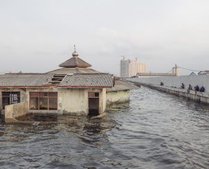
The reason Jakarta is vulnerable is both due to climate change and problems created by the city. Like many other coastal cities built on low-lying land, Jakarta is threatened by sea level rise caused by melting polar ice and expansion of the ocean due to warming (Kimmelman & Haner, 2017). Another issue is that the city is built on a swampy land with 13 rivers running through it (Bentley, 2019). One would think that a city with a tropical climate that gets so much rain has plenty of water and that its aquifers are fully replenished. However, that is far from the truth. Jakarta is known for its lack of parks – everywhere you look, there is concrete and highrise buildings (Kimmelman & Haner, 2017). There is nothing to absorb the water as swamps and mangroves have been replaced by roads and buildings. With heavier and more frequent storms, the rivers overflow and flood the city, especially during the monsoon season.
Despite these serious issues, the most severe threat comes from relative sea-level rise due to subsidence. Jakarta is sinking at an alarmingly high rate due to groundwater extraction (Mayuri & Hidayat, 2018). Most people and businesses in Jakarta don’t have access to piped water, so they pump water from wells, often illegally. However, the consequence of pumping the aquifers excessively is land subsidence – buildings are flooded, and cracks destroy their structure, making them unsafe to live in.
The impacts of the relative sea-level change are devastating. The city has already sunk 4 meters in the past 3 decades and continues to sink at an average rate of 8 cm per year – with some parts of the city up to 25 cm (Mayuri & Hidayat, 2018). 95% of the Northern part of Jakarta is predicted to be underwater by 2050.
The government knows that groundwater extraction is a major problem and that a solution would be to provide clean piped water. They already regulate how much water can be pumped from wells. However, many don’t trust the government and continue to pump water and dig illegal wells, which is a huge problem (Kimmelman & Haner, 2017). In 2005, a $40 billion plan to build a 15 miles giant sea wall and 17 artificial islands began in order to protect the city from rising sea levels. However, the project has met many complications that have slowed down the construction (NASA, n.d.). There are also concrete plans to move the capital, although not the whole city, to a new location on Borneo – with plans to start construction later this year (Dobson, 2020).
Sources
Bentley, C. (2019, May 31). Jakarta’s fight against flooding. The GroundTruth Project. https://thegroundtruthproject.org/jakarta-climate-change-flooding-podcast/.
Brown, S. & Nicholls, R. (2021, March 17). Sea levels are rising fastest in big cities – here’s why. The Conversation. https://theconversation.com/sea-levels-are-rising-fastest-in big-cities-heres-why-157077.
Dobson, J. (2020, January 21). As Jakarta Sinks, a new Futuristic capital city will be built On Borneo. Forbes. https://www.forbes.com/sites/jimdobson/2020/01/20/as-jakarta sinks-a-new-futuristic-capital-city-will-be-built-on-borneo/?sh=2036c0bc527b.
Kimmelman, M., & Haner, J. (2017, December 21). Jakarta is sinking so fast, it could end up underwater. The New York Times. https://www.nytimes.com/interactive/2017/12/21/world/asia/jakarta-sinking climate.html.
Mayuri M. & Hidayat R. (2018, August 12). Jakarta, the fastest-sinking city in the world. BBC News. https://www.bbc.com/news/world-asia-44636934.
NASA. (n.d.). As Jakarta grows, so do the water issues. NASA. https://earthobservatory.nasa.gov/images/148303/as-jakarta-grows-so-do-the water-issues.
Jakarta. (2021, August 5). In Wikipedia. https://en.wikipedia.org/wiki/Jakarta.
Picture credit: https://thegroundtruthproject.org/jakarta-climate-change-flooding-podcast/.
Effect of Sea Level rise on the Island Funafuti of Tuvalu
Chris Annear, Industrial Engineering, Penn State Behrend
Through an increase anthropogenic emissions leading to hotter temperatures and temperature variation, the global sea level has been rising steadily since 1900 due to melting glaciers/ice shelves and thermal expansion. Although the current sea level has only risen .2 meters globally, the sea height variation has reached over 1 meter (Earth Science Communications Team, 2021). For any community close to sea level this is cause for concern. During periods of high tide or during strong storms the chance for extreme flooding increases drastically, which can be financially devastating to low-income communities.
The island nation of Tuvalu is one of the smallest countries by population and area, with just under 11 thousand people and under 26 sq kilometers across all 9 islands. The majority of people live on the island Funafuti (Roy, 2019). These islands are particularly vulnerable to the sea level rise because most of the land is less than 4 meters above sea level, which means they have almost no natural protection from tropical storms and flooding. Additionally, some of the lower lying islands stand a chance of being entirely under water during sea level rise (Roy, 2019).
Many scientists have estimated that the island could be uninhabitable by the end of the century (Roy, 2019). This means the entire population would lose all property that they are not able to move off the island. Such a move would be financially devastating to everyone affected. Additionally, the country would likely be dissolved when this island is evacuated, and all former citizens would become stateless refugees.
Even if CO2 emissions where to abruptly halt, it is likely that ice melting and sea level rise would continue long enough to render the island uninhabitable. For the community affected, there are a variety of investments they could make to combat the issues brought about by rising sea level. An investment in
desalination plants would combat the shortage of freshwater. A sea wall and drainage canal could lessen the effects of flooding. However, it is likely that the nation cannot afford such projects (Roy, 2019).
Sources
Roy, E. A. (2019, May 16). ‘One Day We’ll Disappear’: Tuvalu’s Sinking Islands. The Guardian. https://www.theguardian.com/global-development/2019/may/16/one-day-disappear-tuvalu-sinking-islands-rising-seas-climate-change.
Earth Science Communications Team. (2021, 13 September). Sea Level Rise. Climate.nasa.gov. https://climate.nasa.gov/vital-signs/sea-level/.
Nor’ Easter Storms in Cape Cod
Amelia Arthur, Pennsylvania State University
Cape Cod, Massachusetts faces some of the most devastating effects of climate change. Being from Massachusetts and someone who summers down the Cape, the beautiful coast means so much to me. For the past 50 years or so, though, the Cape has been through a lot. Nor’ Easters have taken out a beloved landmark, Liam’s Clam Shack, which called Nauset Beach home for 63 years (Fraser, 2018). Nor’ Easters have increased in both frequency and intensity and the same goes for other severe weather (Ciurczak, 2018). Part of Massachusetts residents’ charm is their ability to withstand severe winter storms and their minimal fear of snow, but something Massachusetts residents cannot shake is the impending doom that these growingly intense Nor’ Easter storms present. Coastal Cape residents are at great risk not only from the winter storms but from the dramatic increase in sea levels and erosion of beaches.
Since 1922, the sea levels around Cape Cod have risen a whopping 11 inches (Fraser, 2019). Increased sea levels lead to increased flooding, and have been destructive to marsh and wetland habitats which are integral to the balanced Cape ecosystem (World of …, n.d.). Towns have set up ocean barriers and other structures to protect the coast and coastal homes, but as each barrier is put up, there is a storm stronger than the last one to render them ineffective. Some residents have already been forced to leave their beloved homes behind, and as more residents are expected to leave as sea levels, fiercer tides, and more dangerous storms present during the fall and winter months. Residents who are near the coast are advised to take precautions against severe winds, which tend to reach 50 mph (Fraser, 2019).
Revetments have been installed in an attempt to protect homeowners and their homes from dangerous waves and sea spray which can be unpredictable at times (Fraser, 2019). These revetments can be very costly, and even then, can still be eroded by the receding coastlines. In conclusion, coastal Cape residents are faced with a lose-lose situation. Since the glaciers will not refreeze in our lifetimes, or the lifetimes of those Cape residents, it is only a matter of time until evacuation is necessary, and Massachusetts loses their beloved ‘arm.’
Sources
Ciurcsak, P. (2018, March 22). It’s Not Just You: Nor’Easters Really Have Gotten More Frequent And More Intense. Boston Indicators. https://www.bostonindicators.org/article pages/2018/march/nor-easters.
Fraser, D. (2018, March 5). ‘End of an Era’ for Liam’s in Orleans. Cape Cod Times. https://www.capecodtimes.com/story/news/disaster/2018/03/06/end-era-for-liam/13604947007/.
Fraser, D. (2019, June 20). Report: Sea Level Rise to Hit Cape Cod Hard. Cape Cod Times. https://www.capecodtimes.com/story/news/2019/06/20/report-sea-level-rise-to/4790588007/.
World of Change: Coastline Change. (n.d.). NASA Earth Observatory.
https://earthobservatory.nasa.gov/world-of-change/CapeCod.
Matthew Bowers, Earth Sustainability Certificate, World Campus
For the city of Mumbai, India, sea level rise is a concern that puts its large population at risk. Mumbai has a population of more than 20 million people, making it the second-most populous city in India and the sixth-most populous city in the world (Mumbai, India…, 2021). Tide gauge data indicate that sea level rose around 9 cm during the 20th century, however, the rate of sea rise is projected to increase as climate change progresses. Specifically, the rate of 1.8 mm/year in the 20th century has given way to a rate of 3.0 mm/year today (Daigle & Singh, 2018). By 2100, sea levels are projected to rise more than half a meter (NASA, 2021). This issue is amplified by the monsoon season, which brings heavy rains and additional flooding to the city. Additionally, a large portion of the city is built atop landfill; the peninsula where Mumbai stands used to consist of several islands with passages that allowed water to flow during flooding events. Today, there is no such relief. The residents of Mumbai are vulnerable because of the city’s high poverty rates, high population density, and inadequate sewage and drainage systems (Daigle & Singh, 2018). Rising seas will put millions of lives at risk, primarily the poor who live in the most vulnerable areas and lack the resources to recover from frequent flooding (Patel, 2021). Not to mention, businesses that boost the local economy and that residents rely on to provide for their families will also suffer. A typical solution to rising seas: walls and other hard structures, will not work in Mumbai, as they would inhibit the draining of freshwater floods that flow from higher elevations during the monsoon season. Some of the best solutions include “soft” structures, like maintaining and restoring coastal mangrove habitat and protecting sand dunes (Daigle & Singh, 2018) The roots of mangrove forests reduce flooding and erosion, dissipate wave energy, and even sequester large amounts of carbon (Patel, 2021). Additionally, the city of Mumbai should avoid further development along the coast that would decrease the ability of the ground to absorb water (Daigle & Singh, 2018). The storm drainage system could also be improved, but this will only work for so long (Patel, 2021). Ultimately, Mumbai will have to adjust to life where coastal flooding is the new norm, possibly by raising structures, replacing roads with ferries, or relocating residents. Overall, sea level rise will continue to intensify, and residents will have to adapt faster than the water to avoid critical loss and destruction.
Sources
Daigle, K., & Singh, M. (2018). As waters rise, coastal megacities like Mumbai face catastrophe. Science News. https://www.sciencenews.org/article/waters-rise-coastal-megacities-mumbai-face-catastrophe
Sea Level Projection Tool: Mumbai/Bombay. (2021). NASA. https://sealevel.nasa.gov/ipcc-ar6-sea-level-projection-tool?psmsl_id=43
Patel, A. (2021). Mumbai: The city that was born of the sea may eventually be consumed by it. Scroll.in. https://scroll.in/magazine/1004151/mumbai-the-city-that-was-born-of-the-sea may-eventually-be-consumed-by-it
Mumbai, India Population. (2021). Population Stat. https://populationstat.com/india/mumbai
Failure to Keep up with Climate Adaption Drowns Newtok, Alaska
Anna Capria, Biobehavioral Health with a minor in Biomedical Ethics, Penn State University
Newtok, Alaska is extremely vulnerable to rising temperatures because it relies on Alaskan permafrost for its existence (Newtok, Alaska, 2021). This small village consists largely of indigenous people. About 400 people live in only about 63 households in Newtok. The majority of households in Newtok have children under 18, and about 11% of the households in Newtok are headed by single women with no husband. The median income per household in Newtok is just $32,188 (Newtok, Alaska, 2021). For these reasons, Newtok, Alaska is an isolated and extremely vulnerable community.
The future of Newtok, Alaska is bleak. The permafrost in Alaska is melting quickly due to climate change. Severe storms, also worsened by climate change, melt permafrost and wear away the land on which Newtok sits. Today, Newtok has sunk below sea level and is forecasted to possibly go underwater in the next ten years. The entire barge dock of Newtok has been completely destroyed by erosion (Newtok, Alaska, 2021). Those who are native to Newtok report light posts leaning sideways and boardwalks bending as they sink into the sea (Ilhardt, 2021). This is all due to the failure of the community to adapt to climate change. This failure to adapt is hardly Newtok’s fault, given the lack of resources to address the problem. The small community has lost over 100 feet of land so far, yet there has been little effort to save this village from disappearing beneath the waves. Many indiginous people have lived in Newtok their entire lives and are reluctant to leave, fearing that relocating would completely disrupt their way of life and culture (Ilhardt, 2021).
Despite the residents’ cultural concerns, solutions for Newtok focus largely on relocation (Ilhardt, 2021). It is unlikely that efforts to reverse climate change on a global scale will be effective quickly enough to help Newtok (Simmons, 2020). Some Newtok residents have already relocated to Mertarvik, a nearby Alaskan town (Ilhardt, 2021). Eventually, everyone in Newtok will be forced to move to safer, higher ground, but the recent global pandemic has halted progress as well as divided the community.
Sources
Ilhardt, J. (2021, June 8). “It Was Sad Having to Leave”: Climate Crisis Splits Alaskan Town in Half. The Guardian. https://www.theguardian.com/environment/2021/jun/08/it-was-sad-having-to-leave-clima te-crisis-splits-alaskan-town-in-half.
Simmons, D. (2020, October 16). What Is Climate Change Adaptation, and Why Does It Matter? Yale Climate Connections. https://yaleclimateconnections.org/2019/12/what-is-climate-change-adaptation-and-why does-it-matter/.
Newtok, Alaska. (2021, October 29). In Wikipedia. Retrieved December 2, 2021. https://en.wikipedia.org/wiki/Newtok,_Alaska.
Severe Storms Scar Shishmaref, Alaska
Anna Capria, Biobehavioral Health with a minor in Biomedical Ethics, Penn State University
For a small village in northwestern Alaska, climate change is making a real and immediate impact: the village is eroding into the sea. Shishmaref, Alaska is a small village near the Arctic Circle with approximately 600 people (Shishmaref, Alaska…, 2021). The community is particularly vulnerable because the vast majority of its residents (more than 91%) are Native Americans, 40% are below the poverty line, and fewer than 15% have attained a Bachelor’s or graduate degree (Shishmaref, Alaska…, 2021). Shishmaref is located on Sarichef Island, just five miles from the Alaskan mainland (The History…, n.d.). The island on which Shishmaref is located is a sand barrier island protected by a thick layer of permafrost (Showstack, 2020).
The problem is that the protective ice surrounding the island is melting due to climate change and the greenhouse effect (Martin, 2018). As a result, the waves of the Chukchi Sea that used to hit the ice barrier now break on the shoreline, eroding the land in the process (Martin, 2018). The melting permafrost, rising sea levels, and resulting flooding combine to rank Shishmaref as the second worst community in Alaska in terms of risk from climate change, according to a 2019 report to the Denali Commission (Showstack, 2020). The situation is exacerbated when storms hit. A single storm in October 1997 eroded 30 feet of shoreline and forced the relocation of 14 homes (The History…, 2021). Another storm in 2005 eroded even more land (Martin, 2018).
The forecasted impacts of climate change on Shishmaref are obvious in its shrinking land area as a result of coastal erosion, but riparian (riverbank related) erosion and flooding are also obvious threats to infrastructure, including roads, bridges, hospitals, and schools (University of Alaska Fairbanks et al., 2019). What is less obvious is that the layer of protective permafrost that surrounds the island also forms part of its foundation. As the permafrost melts, the foundation of the island becomes less stable, which further threatens infrastructure. The situation is so dire that the community has voted three times to relocate the entire town to the mainland (Showstack 2020). Doing so, however, could destroy the culture of the community, which is majority Inupiat, with a distinctive dialect and their own traditions (Martin, 2018).
The solutions for the problems that Sishmaref faces as a result of climate change are complex. A temporary solution is to build a sea wall, which is what the Army Corps of Engineers did in 2005 following a severe storm. Another partial short-term solution is to move homes and infrastructure away from the vulnerable shoreline, but given the limited land mass of Shishmaref, the efficacy of such a step is questionable (University of Alaska Fairbanks et al., 2019). Another solution that may be required is relocation of the entire community, but that would be tremendously expensive and difficult (University of Alaska Fairbanks et al., 2019; Martin 2018). Finally, a solution that may be out of reach, at least in the short term, is to reverse the impacts of climate change by significantly reducing greenhouse emissions on a global scale (Climate Change…, 2022).
Sources
Martin, A. (2018, October 22). An Alaskan village is falling into the sea. Washington is looking the other way. The World from PRX.
https://www.pri.org/stories/2018-10-22/alaskan-village-falling-sea-washington-looking-other-way.
Climate Change Indicators: Greenhouse Gases. (2022, April 27). Environmental Protection Agency. https://www.epa.gov/climate-indicators/greenhouse-gases.
Showstack, R. (2020, February 7). Helping Alaskan Communities FACING climate risks. Eos. https://eos.org/articles/helping-alaskan-communities-facing-climate-risks.
Shishmaref, Alaska population 2021. (n.d.). World Population Review. https://worldpopulationreview.com/us-cities/shishmaref-ak-population.
University of Alaska Fairbanks Institute of Northern Engineering, U.S. Army Corps of Engineers Alaska District, & U.S. Army Corps of Engineers Cold Regions Research and Engineering Laboratory. (2019, November). Statewide Threat Assessment: Identification of Threats from Erosion, Flooding, and Thawing Permafrost in Remote Alaska Communities. https://www.denali.gov/wp-content/uploads/2019/11/Statewide-Threat-Assessment-Final-Report-November-2019-1-2.pdf.
The History of Shishmaref. (n.d.). ExploreNorth. https://explorenorth.com/library/communities/alaska/bl-Shishmaref.htm.
Emma Cox, Earth Science and Climatology, College of Earth and Mineral Sciences
The effects of climate change, those happening currently and those still to come, have begun to loom ominously in the back of the everyday person’s mind. By focusing on communities, this gives the opportunity to observe and discuss the effects of climate change to a level more people can relate to. That is why the community of New Orleans, Louisiana is an interesting place to start this discussion. Because of its geographical location and proximity to water, the city has already begun to see the repercussions from anthropogenic CO2 emissions and lack of climate justice. Located at an outlet of the Mississippi River on the coast of the Gulf of Mexico with half of the city below sea level, New Orleans is a good place to begin an investigation of the local effects of climate change.
Rising sea levels are one of the main threats to this southern city, as it requires levees and spillways to retain its ground at an elevation below sea level. As CO2 emissions melting the ice caps are predicted to increase the sea level in the area up to almost 5 feet, the city has struggled to deal with more frequent extreme precipitation and flooding (Mehta, 2011). Michael Patrick Welch (2019), an author local to New Orleans, discussed how the pumps that used to keep the city’s groundwater at bay haven’t been working properly due to excessive flood-causing rains, which leads to even more street flooding in areas that weren’t exposed to it in the past. This increased severity in precipitation events, which includes tropical storms, is caused by increasing sea water temperatures (Welch, 2019). Flooding along the Mississippi River has also added to New Orleans’s rising water issue, as well as contributing to the closing of major freeways and the destruction of bridges in the area. (Cusick, 2019).
However bleak the water situation appears in New Orleans, the city has had to respond to the increasing severity of its precipitation and flooding. There are current and future efforts planned to construct new zones for the levees and spillways to disperse the water, as well as funding allocated to rebuild old infrastructure into more flood-friendly elevated structures (Mehta, 2011). Many are considering leaving the sinking city, though there is no doubt that poor families will struggle the most in adapting or relocating because of this climate crisis. Though many families are shamed for not leaving areas in immediate danger of tropical storms or flooding, they simply lack the resources needed to escape these tragedies and will need help in the future to deal with the rising troubles of the New Orleans water problems (Howell, 2020).
Sources
Cusick, D. (2019, May 13). Today’s Floods Occur along “a Very Different” Mississippi River. Scientific American. https://www.scientificamerican.com/article/todays-floods-occur-along-a-very-different-mississippi-river/
Howell, Z. (2020, August 31). Katrina, Climate, and Justice: A Future in Foreshadow? NRDC. https://www.nrdc.org/stories/katrina-climate-and justice-future-foreshadow
Mehta, M. (2011, July). NRDC: New Orleans, Louisiana-Identifying and Becoming More Resilient to Impacts of Climate Change. NRDC. https://www.nrdc.org/sites/default/files/ClimateWaterFS_NewOrleansLA.pdf
Welch, M. P. (2019, November 11). New Orleans Is Slowly Drowning. When Do I Leave? Vice. https://www.vice.com/en/article/ne8gw7/new-orleans is-slowly-drowning-thanks-to-climate-change
Ryan Crinnigan, Digital Journalism and Media, World Campus
La Paz, Bolivia is the world’s most highly elevated national capital, lying between 3,200 and 4,100 meters above sea level. It is Bolivia’s third-most populous city, with around 810,000 residents, and its metropolitan area contains around 2 million people. Rapidly melting glacier ice has placed water availability in La Paz at serious risk.
La Paz lies near the Tuni glacier. The Tuni glacier is located in the Cordillera Real, a mountain range east of La Paz. Runoff from the glacier feeds rivers and provides around 20% of La Paz’s water supply. Like glaciers around the world, the Tuni is shrinking, and the rate of shrinking is faster than scientists anticipated. In April 2021, researchers reported in the journal Nature that glacier loss accelerated significantly in the 2000s, from about 227 gigatons of annual ice melt in 2004 to 298 gigatons annually in 2015 (Glaciers melting…, 2021). The Tuni has suffered over years of melting. Ice has disappeared, leaving large expanses of rock. Scientists foresaw the melting of the glacier, but recent reports surprised them with the extent and speed of ice loss. Satellite images reveal that the glacier has shrunken to one square kilometer (Machicao, 2021). Snowcaps on nearby mountain ranges, which used to be visible year-round, have disappeared, and the world’s highest ski resort has closed due to such significant melting (Melting snowcaps…, 2019).
As global warming has driven rural citizens to urban areas, the strains on water systems grow deeper. Not only is La Paz a large urban area, but its sister city El Alto has been growing at around 5% a year. So when other natural crises such as drought strike, there is a sort of double whammy of less water available from the glacier while more and more people rely on it as regional population grows. Furthermore, the researchers in Nature noted that not only are glaciers rapidly melting, but that Andean glaciers are melting at some of the fastest rates in the world (Melting snowcaps…, 2019). Without the glacier runoff, La Paz and surrounding areas have no natural second option for water, and rivers used for irrigation would have no source.
Residents are turning to unconventional methods to fight against the compounding water issues in Bolivia, especially after suffering a particularly difficult drought from 2016 to 2017, a drought that forced the president of Bolivia to declare a state of emergency. Many have used public wash-houses to reduce single-home water usage and pool resources with fellow residents. Others have developed methods to store rainwater. And the Bolivian government committed to constructing four reservoirs using water from Andean lagoons (Melting snowcaps…, 2019). Regardless of these efforts, observers fear that the impact of the previous drought did not make a long-term impact on water awareness. As the glacier slowly but surely disappears entirely, La Paz residents may find themselves without a second water option during mass shortages.
Sources
Glaciers melting at a faster rate, new study finds. (2021, April 28). Al Jazeera.
https://www.aljazeera.com/news/2021/4/28/world-glaciers-melting-at-fast-rate-new-study-finds. Accessed 13 Dec 2021.
Machicao, M. (2021, January 4). Bolivia’s Tuni glacier is disappearing, and so is the water it supplies. Reuters. https://www.reuters.com/article/us-bolivia-environment-glacier-idUSKBN29929U?taid=5ff3c8225b2aa00001364c41&utm_campaign=trueanthem&utm_medium=trueanthem&utm_source=twitter.
Melting snowcaps spell water trouble for world’s highest capital. (2019, September 19). France24. https://www.france24.com/en/20190919-melting-snowcaps-spell-water-trouble-for-world-s-highest-capital.
Melting Permafrost in Norilsk, Russia
Rachel Crozier, Political Science, World Campus
The city of Norilsk, Russia, is the northernmost city in the world, located above the Arctic Circle. The city has around 180,000 permanent inhabitants (Norilsk, 2021). The main industry there is mining. The land is rich with nickel, copper, and palladium. The region was originally home to small groups of indigenous people. It was later settled as an outpost of Stalin’s Gulag, functioning as a resource colony. Between 1935 and 1956, it is estimated that 650,000 prisoners were sent there to work in the harsh conditions (Higgins, 2017). It is still a mining community, but today people brave the harsh conditions for relatively higher wages mining the valuable resources.
A major concern for Norilsk is melting permafrost. While the city is located in what is called the permanent permafrost zone, the temperatures in the Arctic region are rising faster than anywhere else in the world. They are projected to continue rising. As the permafrost melts and the ground becomes unstable, the foundations of buildings are at risk. According to a report in Arctic Today, 60% of the buildings in Norilsk are showing signs of structural damage. One-tenth of homes have been abandoned (Schreiber, 2020). Roads are in constant need of repair. Along with the warming climate, other factors are speeding up the permafrost melt, such as warmth from the buildings, leaking pipes, and sewer systems. As detailed in The New York Times, industrial infrastructure is also becoming damaged, adding to the pollution (Kramer, 2020). In 2020, a major diesel fuel spill occurred when a tank collapsed into the melting permafrost due to the warming soil. This pollution adds to another major risk to the people in and around Norilsk. It is known as the most polluted city in the world, largely a result of its nickel smelting industry. (Norilsk, 2021).
The people in Norilsk are isolated and at risk of losing their homes, or worse – becoming injured by collapsing structures. They are also at risk of developing health problems due to pollution from factories and damaged industrial infrastructure. As reported by NBC, Norilsk residents have a higher percentage of lung cancer than those living in other cities in Russia (Lavelle, 2021). Additionally, the city is very isolated. There are no roads or passenger trains between Norilsk and other parts of Russia below the Arctic circle (Higgins, 2017). It is as if the city were an island, only accessible by air travel or boat.
To combat the infrastructure problems, the city will need to update their building codes and rebuild many of the damaged structures with more stability. It is estimated the permafrost damage will cost $80 billion to repair (Schreiber, 2020). The city installed high-tech cooling systems underground to help slow the permafrost thaw in 2019 and 2020. The factories responsible for pollution must adopt lower emissions standards, as well as invest to protect their equipment from structural damage. Additionally, a coordinated worldwide effort to reduce carbon emissions is imperative to slow rising temperatures.
Sources
Higgins, A. (2017, December 3). The Lure of a Better Life, Amid Cold and Darkness. The New York Times. https://www.nytimes.com/interactive/2017/12/03/world/europe/norilsk-arctic.html
Kramer, A. (2020, June 9). Major Fuel Spill in Russia’s North Spreads Toward Arctic Ocean. The New York Times. https://www.nytimes.com/2020/06/09/world/europe/russia-arctic-oil-spill.html?searchResultPosition=7
Lavelle, M. (2021, November 28). How Norilsk, in the Russian Arctic, Became One of the Most Polluted Places on Earth. NBC News.
https://www.nbcnews.com/news/world/norilsk-russian-arctic-became-one-polluted-places-earth-rcna6481
Norilsk. (2021, December 12). In Wikipedia. https://en.wikipedia.org/wiki/Norilsk
Schreiber, M. (2020, June 8). The Massive Norilsk Fuel Spill Could Be Linked to Permafrost Thaw, a Growing Threat to Arctic Infrastructure. Arctic Today.
https://www.arctictoday.com/the-massive-norilsk-fuel-spill-could-be-linked-to-permafrost-thaw-a-growing-threat-to-arctic-infrastructure/
Esteban Galindo-Carvajal, Architecture, Penn State University
Akiak is a community in Alaska with a population of a couple hundred people. The small town sits on the bank of Kuskokwim River. In the Summer of 2017, after a particularly warm spring, permafrost melting caused the river to swallow roughly a mile of riverbank along the length of the community.
Akiak is vulnerable because of how quickly the riverbank is approaching settlements. Multiple homes were described as being in imminent danger including one that is within 20 feet of the new riverbank. At the time of the original event, non-living structures were lost to the river, but luckily no homes. Another reason why the community is vulnerable is because some of the houses are simply too old to move.
As permafrost melting continues, so will the erosion of the riverbank towards the community’s houses. Behind the town as well, there is an inlet and community members predict that the path of the river and its erosion is likely to meet the inlet. In this case, the small community would be cut off from land and become an island as the river channels around it. Additionally, as surface ground temperatures change, roads and building foundations are suffering from thermal expansion. Foundations are cracking and roads are slumping and will continue to do so as long as preventive measures are not taken at the necessary scale.
The primary solution is to move houses both in the sense of moving somewhere else, or physically changing the location of existing houses. Other solutions are makeshift methods of stabilizing the eroded banks. Sandbags, tarps, and metal poles are among the methods used by community members to protect their houses while the community waits for emergency funds and action.
Sources
Alaskans Consider Staying in Homes Threatened by Erosion. (2019, June 26). AP NEWS. https://apnews.com/b865f64bd84740d08dd7485a8e259a69.
Fountain, H. (2017, AUgust 23). Alaska’s Permafrost Is Thawing. The New York Times. https://www.nytimes.com/interactive/2017/08/23/climate/alaska permafrost-thawing.html.
Kim, Greg, et al. (2019, October 29). In Erosion-Threatened Akiak, Emergency Management Officials Assess Aid Options. Alaska Public Media. https://www.alaskapublic.org/2019/10/29/in-erosion-threatened-akiak-emergency management-officials-assess-aid-options/.
Kim, Greg. (2019, March 22). Akiak Loses a Mile of Riverbank to Erosion. KYUK. https://www.kyuk.org/post/akiak-loses-mile-riverbank-erosion.
Milman, O. (2019, June 14). Climate Crisis: Alaska Is Melting and It’s Likely to Accelerate Global Heating. The Guardian.
https://www.theguardian.com/environment/2019/jun/13/climate-crisis-alaska-is-melting and-its-likely-to-accelerate-global-heating.
Coastal Sea Level Rise at Plum Island Newburyport, MA
Esteban Galindo-Carvajal, Architecture, Penn State University
Plum Island is a coastal community in Newburyport, Massachusetts, near the New Hampshire border. Within the past decade, Plum Island has faced serious erosion and flooding. According to some residents, they have seen roughly 400 feet of beaches washed out to sea and redeposited elsewhere in this period. With increases in storm intensity, residents experience frequent flooding that increases the rate of erosion, property damages, and the threat that any storm could wipe out the neighborhood.
The reason for the vulnerability of Plum Island is that it sits on what is basically a large sand bar, not solid ground. It is surrounded by saltwater marshes, and its low-lying land that doesn’t reach more than 10 feet over sea level, and can easily be washed away by storm surges. This region of the country, especially Massachusetts, is susceptible to Nor’easter storms. Winters in Massachusetts hit hard and bring numerous storms that greatly affect coastal communities and require loads of government money to repair and prevent against these storms.
With rising sea levels of 2-11 feet predicted in future climate models, Plum Island is at great risk. According to the real estate app Zillow, given a 6-foot rise in water level, Plum Island could lose 30 percent of its homes if erosion becomes really intense. Sea levels in this area specifically are predicted to reach that level within half of the century. Plum Island in one of many communities nationwide that have received suggestions to retreat from the rising sea level.
With the risk of this barrier beach being submerged in the future, the best solution is to cease development in Plum Island and develop a strategy for a “managed retreat.” However, temporary solutions range from the construction of sea walls and barriers, to lifting houses, and planting sea grasses. Concrete sea and stone sea walls are already common in this area. Currently, these must be expanded and repaired yearly. This strategy could help manage surges brought on by storms and possibly curb the spread of rising sea levels into the island. As seen in other parts of costal Massachusetts, another strategy is to raise the houses on stilts. Raising the houses would place them above the predicted sea level as long as the ground underneath where the pylons and foundations are located does not continue to erode at its current rate. Lastly, planting deep rooted sea grasses helps to hold the eroding sand in place, but in the long run cannot provide the necessary protection from the sea level change threatening to submerge the community.
Sources
Earth Resources Observation and Science (EROS) Center (n.d.). Comparison of Predicted Outcomes for Plum Island, Massachusetts. U.S. Geological Survey. https://www.usgs.gov/media/images/comparison-predicted-outcomes-plum-island-massachusetts.
Lambert, L. O. (2016, December 4). Photos: Facing the Threat of Rising Seas. GBH News. https://www.wgbh.org/news/2016/12/04/local-news/photos-facing-threat-rising-seas.
National Science Foundation, NSF. (n.d.). See Innovation – Plum Island Ecosystems Long-Term Ecological Research Site. Research.gov. https://www.research.gov/research-portal/appmanager/base/desktop;jsessionid=ZwNnYvYQ76Hg2sjjsv8TfN0BJMvl8xr3fk7HL2nqv058TfCH6v12!893808983!579854386?_nfpb=true&_windowLabel=researchAsset s_1_1&_urlType=action&wlpresearchAssets_1_1_id=%2FresearchGov%2FResearchAsset %2FPublicAffairs%2FPlumIslandEcosystemsLongTermEcologicalResearchSite.html&wlp-researchAssets_1_1_action=selectAssetDetail.
Rios, S. (2018, August 2). Entrench or Retreat? That Is the Question on Plum Island. WBUR News. https://www.wbur.org/news/2018/08/02/plum-island-climate-change-entrench-retreat.
Rios, S. (2018, June 28). Plum Island Residents Weigh ‘Green’ or ‘Gray’ Infrastructure in Struggle against Erosion. WBUR News.
https://www.wbur.org/news/2018/06/28/plum-island-erosion-battle.
Relocation of the Yup’ik village, Newtok, Alaska
Clare Gibson, Atmospheric Sciences, Penn State University
The melting of permafrost does more than just release methane into the atmosphere. When the permafrost melts, the ground can become unstable, leading to landslides, flooding, and coastal erosion. Crumbling land has started to affect people’s homes and important infrastructure like roads, pipelines, and foundations to buildings (Cho, 2018). Because of the effect this melting has had on communities, many now need to move elsewhere. One specific community in the process of relocation is the Yup’ik village in Newtok, Alaska.
Flooding and erosion have caused the land around the Yup’ik people’s homes to deteriorate and sink (Welch, 2019). Because their homes are being swallowed by the earth, the Yup’ik people must move to better conditions. Their landfill and fuel tanks have already been compromised by flooding. The warming climate has contributed to rising sea levels. Melting sea ice has cleared the path for storm surges to rush up the rivers and erode the banks, which leads to this water permeating into the communities (Welch, 2019).
Some of the community is already moving to their new homes. They have made a new village named Mertarvik, which is 10 miles southeast of Nelson Island, not far from where they used to live (Welch, 2019). The village has not moved all at once. About 18 families had moved in as of October 2019, and more families are expected to continue to transition until at least 2023 (Welch, 2019).
State and federal agencies have started to give money to Yup’ik people for building Mertarvik’s community center, roads, a landfill, and a power station (Welch, 2019). But many groups facing the same problems do not have access to the same resources that they need to be able to relocate. We need more assistance from the government in finding safe places for these communities to transition to.
Sources
Welch, C. (2019, October 22). Climate change has finally caught up to this Alaska village. National Geographic. https://www.nationalgeographic.com/science/article/climate-change-finally-caught-up-to-this-alaska-village
Cho, R. (2018, January 11). Why Thawing Permafrost Matters. State of the Planet. https://news.climate.columbia.edu/2018/01/11/thawing-permafrost-matters/
Sea level rise and flooding in Venice, Italy
Clare Gibson, Atmospheric Sciences, Penn State University
Venice, Italy is one of the many cities around the world suffering from flooding due to sea-level rise. The best evidence of this is buildings sitting in water that were not there centuries ago (Lavanga, 2020). Being forced to trek through knee-deep water can drive away citizens and tourists alike. This would have a major impact on Venice’s economy.
Not only do these floods impact the people living there and the tourists visiting, but there is also a risk to artwork and historic buildings. For example, St. Mark’s Basilica’s marble floor has been chipped and damaged by salty floodwaters (Bellware, 2019). Many of the buildings in Venice are old, so normal aging and deterioration are already at play. The weight of the city and its citizens overdrawing groundwater is also creating another issue – Venice is sinking (Bellware, 2019). This is known as land subsidence, and can accelerate flooding (Land Subsidence, Module 8).
In November 2019, the second highest tide recorded – 6 feet – was pushed in by 35 mph winds and as a result, 80 percent of Venice went underwater. This flooding event was costly. The price of the damage caused totaled over $1 billion (Lavanga, 2020). Besides the immediate damage to the buildings that can be seen, there are slow and hidden consequences to saltwater. The salt saturates the buildings – marble, tiling, plaster, or wood – and it crystallizes and rises through the building when the weather gets drier (Bellware, 2019). This slow intrusion continues to decrease these structures’ stability and will cause more issues in the future.
It appears that by 2050, sea-level rise will happen regardless of the reduction of emissions (Bellware, 2019). So, the solutions need to be focused on stopping the water from getting into the city, not stopping the water from rising. Previous solutions that Venice has considered involve raising the city by adding layers to its banks and boarding up ground floors once the water level reached them (Lavanga, 2020). But these solutions will no longer be enough. Another idea currently being constructed is a series of barriers at the bottom of three inlets separating the Venetian Lagoon and the Adriatic Sea. These barriers would be raised to form a floodgate when critical levels are reached by sea-level rise (Lavanga, 2020). The current issue with this project is its timeframe. Named MOSE, the project started construction in 2003. Although was meant to be completed by 2012, is expected to be fully operational by the end of 2021 (MOSE, 2021; Lavanga, 2020; Benningfield, 2021). Until we can see the effectiveness of the floodgates, the best solution may be working on assisting displaced citizens and fixing immediate damage to buildings as best as they can.
Sources
Venice floods: Climate change behind highest tide in 50 years, says mayor (2019, November 13). BBC News. https://www.bbc.com/news/world-europe-50401308
Lavanga, C. (2020, February 16). As sea levels rise, Venice fights to stay above the waterline. NBC News. https://www.nbcnews.com/news/world/sea-levels-rise-venice-fights-stay-above-waterline-n1135661
Bellware, K. (2019, November 17). Venice floods threaten priceless artwork and history — and a unique way of life. The Washington Post. https://www.washingtonpost.com/history/2019/11/17/venice-floods-threaten-priceless-artwork-history-unique-way-life/
Module 8, ‘Land Subsidence’
Benningfield, D. (2021, October 14). For Venice’s Floodgates to Work, Better Forecasts Are Needed. Eos. https://eos.org/articles/for-venices-floodgates-to-work-better-forecasts-are-needed
MOSE. (2021). In Wikipedia. https://en.wikipedia.org/wiki/MOSE
Laura Guay, Biobehavioral Health, University Park
Charleston is particularly vulnerable to ice melting and rising sea levels because it is right along the coast (EPA, 2016). However, the flooding increasing sea levels has gone beyond the beachfront areas to impact streets throughout the city (EPA, 2016).
About 50 years ago, Charleston reported flooding on approximately 2 days per year, but it is now thought that the city will experience flooding approximately every other day by 2045, given that the sea level around the city is now increasing by 1 inch biannually (EPA, 2016; SeaLevelRise, n.d.). This city is particularly vulnerable to this because the land is sinking (EPA, 2016; Sea Grant, 2019). The low elevations and insufficient draining systems cannot handle rising sea levels (Magill, 2014). This is especially concerning to human health, as most medical services in Charleston are in areas of low elevation; during flooding, there is no way to evacuate patients or bring in new patients (SeaLevelRise, n.d.).
Some of the forecasted impacts on the community include both damaging people’s homes as well as forcing people to pay high insurance rates (EPA, 2016). By 2033, it is expected that over 8000 houses will be impacted by flooding in the city (SeaLevelRise, n.d.). The flooding also impacts organisms in the wetlands, resulting in loss and damage to those ecosystems (Magill, 2014). Moreover, some 1000 acres of barrier islands around Charleston have already been flooded (Magill, 2014).
Some solutions to the threat include building seawalls, increasing draining efforts, and raising the level at which the roads are built (SeaLevelRise, n.d.). In 2007, the Charleston City Council took efforts to combat the effects of climate change in their city through developing something known as the Green Committee, part of which worked on responding to increasing sea levels (Magill, 2014). Unfortunately, although City Council looked at the plan, they did not act. There are concerns that this city, with many climate change skeptics, is largely underprepared for the impacts of rising sea levels (Magill, 2014). However, the current mayor, John Tecklenburg, ran on a platform to protect the city from this threat (Bailey, 2020). Some of his efforts have involved consulting with the Dutch to learn how to live around water, creating rules about what types of buildings can be constructed and where they can go, and developing pumps and underground tunnels (Bailey, 2020). Overall, it is projected that a $2 billion budget is needed to address rising sea levels, and raising money has been difficult (Bailey, 2020). This example shows that, despite the climate skeptics in this community, efforts are still possible.
Sources
Bailey, S. (2020, February 12). How Charleston, South Carolina, is working to save itself from climate change. Newsweek. https://www.newsweek.com/how-charleston-south-carolina-working-save-itself-climate-change-1486564.
EPA. (2016). What Climate Change Means for South Carolina. United States Environmental Protection Agency. https://19january2017snapshot.epa.gov/sites/production/files/2016-09/documents/climate-change-sc.pdf.
Magill, B. (2014, January 9). The front lines of climate change: Charleston’s struggle. Climate Central. https://www.climatecentral.org/news/the front-lines-of-climate-change-charlestons-struggle-16934.
Sea Grant. (2019, October 25). Sea-level rise: Adapting to a changing coast. S.C. Sea Grant Consortium. https://www.scseagrant.org/sea-level rise-adapting-to-a-changing-coast/.
SeaLevelRise. (n.d.). South Carolina’s sea level is rising. Sea Level Rise. https://sealevelrise.org/states/south-carolina/.
Rising Sea Levels in Tampa Bay, FL
Adia Hartmann-Snyder, Biobehavioral Health, Health and Human Development (Alumna)
Rising sea levels are a real threat in the world. According to Climate.gov, the rate of sea level increase has more than doubled since the 20th century. In addition, flooding due to high tides happens 300-900% more often than it has in the past (Lindsey, 2020). According to NASA, there are two main causes of sea levels rising. The first is that global temperatures rising causes glaciers to melt, which in turn adds to the overall volume of the oceans. The second is that the higher temperature of the water causes the oceans to expand (Sea Level, 2021). Tampa Bay is among one of the communities most susceptible to the impact of rising sea levels.
Tampa Bay is particularly vulnerable to rising sea levels because it is a coastal city. According to Climate.gov, about 40% of the US population lives on a coast (Lindsey, 2020). This means that there is greater risk of enormous economic impact of rising sea levels. With rising sea levels comes greater risk for flooding, creating a greater risk for property damage (Neumann et al., 2000).
Experts have predicted that sea levels will rise in the Tampa Bay area by about 2 to 8.5 feet by 2100 (Quintana, 2021). The forecasted increase in sea level of 8.5 feet is a worst-case scenario prediction. According to Climate.gov, even if we reduce emissions, the sea levels will probably still rise by about 12 inches by 2100 (Lindsey, 2020).
One possible solution for the threat of rising sea levels is improving infrastructure of Tampa Bay to prevent extensive damage from flooding (Sea level…, n.d.). Another option would be to raise up roads to prevent them from being flooded (Sea level…, n.d.). The community could also build stormwater pumps to aid in draining water back out to the ocean. One last option for solving this problem is to build seawalls to protect the city from being flooded (First Street Foundation, 2018).
Sources
First Street Foundation. (2018, November 24). Solving for Sea Level Rise. Medium. https://medium.com/firststreet/solving-for-sea-level-rise-b95600751525
Lindsey, R. (2020). Climate Change: Global Sea Level. Climate.gov. NOAA. https://www.climate.gov/news-features/understanding-climate/climate-change-global-sea-level
Quintana, A. (2021). How climate change will impact Tampa Bay over the next decade, according to the latest UN report. Tampa Bay News 10.
https://www.wtsp.com/article/tech/science/environment/climate-change-tampa-bay-un-report/67- 152802f0-f09a-4502-a527-34f6991e68f0
Sea Level. (2021). Climate Change: Vital Signs of the Planet. https://climate.nasa.gov/vital-signs/sea-level/
Neumann, J. E., Yohe, G., Nicholls, R., & Manion, M. (2000, February). Sea-Level Rise & Global Climate Change: A Review of Impacts to U.S. Coasts. Center for Climate and Energy Solutions. https://www.c2es.org/document/sea-level-rise-global-climate-change-a-review-of-impacts-to-u-s-coasts/
Sea level rise solutions. (n.d.). Sea Level Rise.org. https://sealevelrise.org/solutions/
Sea Level Rise Impact on Miami, FL
Aran Jacobs, Weather Risk Management, Penn State University
One of the more prominent topics of climate change has to be sea level rise and it’s impact on coastal cities. It is a problem that many in Miami, Florida have had and started planning for. Since 1950, Miami has seen its sea level rise by 8 inches, as measured by buoys off the coast and tide gauges. Scientists have concluded that this is mostly due to melting sea ice, and that is only going to get worse. In fact, sea level in Miami is rising about 1 inch every three years. The National Oceanic and Atmospheric Administration and US Army Corps of Engineers came together to try to forecast future rise in the major Florida city. What they came up with was a model that predicts an average of 15 inches of sea level rise by 2050. Why is this a concern, though, and how will it impact the city? Higher sea levels create a high starting point for storm surges in the event of hurricanes. In fact, in over a third of coastal cities, surge sizes that were once labeled as “once a century” could now be labeled as “once a decade.” In Miami, about 1200 residential properties are currently at risk for tidal flooding, and that number is expected to increase to almost 4000 by 2033. As a result, the USACE created a multibillion-dollar plan that detailed how Miami should combat the crisis. Headlining the plan was a 20-foot seawall in Biscayne Bay, downtown Miami. The plan also outlined natural solutions including installing mangroves and wetlands. These natural remedies would be more cost efficient, improve water quality, and create jobs. It is estimated than an oyster reef installation would provide value of $5,500 to $99,000 annually and would pay for itself in two to fourteen years. Due to the ramifications future sea level rise will have, it is a major concern for the city of Miami. While the proposed solutions are widely supported by the public, it is up to the city and state to take action to mitigate future risk.
Sources
Florida’s sea level is rising. (n.d.). Sea Level Rise. Retrieved December 14, 2021, from https://sealevelrise.org/states/florida/.
Rhode, R. (2021, July 23). Sea level rise threatens Miami’s future. Here’s how the Army Corps can help keep Florida, Florida. Envvironmental Defense Fund. https://blogs.edf.org/growingreturns/2021/07/23/sea-level-rise-threatens-miamis-future/.
Flood Protection. (2021, December 29). Miami-Dade County. Retrieved December 14, 2021, from https://www.miamidade.gov/environment/flood-protection.asp.
Aran Jacobs, Weather Risk Management, Penn State University
We often hear about the distant impacts of climate change and how one day coastal cities are going to be at serious risk. Most people don’t consider the possibility that entire communities would have to relocate completely. That is exactly what is happening to the Inuit and Yupik communities of Newtok, Alaska. The tribes are particularly susceptible because of their locations on the Ninglick River and the Bering Sea. Due to permafrost degradation, rising sea levels, and flooding, the US Army Corps of Engineers estimates that Newtok is eroding up to 90 feet per year. Not only have they already started to lose key infrastructure from climate change, but they will likely soon lose their water supply as well. Thanks to a federal grant, Newtok residents had the opportunity to vote on relocating to a new location, and they voted yes. The process was started in 2003, when the US granted 12,000 acres on Nelson Island to the Newtok Native Corporation. Over the course of the next 15 years, that land was developed into 11 houses, a landing for barges, water wells, and roads. It is expected that everybody in the Newtok community be relocated to their new home of Mertarvik by 2023. This has been no easy task, however. It has required the collaboration of many agencies on multiple levels of government and significant funding. FEMA, US Congress, the US Bureau of Indian Affairs, the US Department of Housing and Urban Development, and many others have combined to put about $50 million dollars into the relocation efforts. That is significant time and financial effort in order to relocate a community of about 350 people in Alaska. Looking deeper into projects like this, it is easy to see how the financial cost of slowing climate change is a drop in the bucket (very small amount) compared to the cost of the impacts of climate change. It may just be one city in Alaska for now, but in 75 years, paying 50 million dollars to relocate every 350 people on coastlines in America will add up. The time is now to get ahead of that and invest in climate resistant infrastructure.
Sources
From Newtok to Mertarvik: A Native Alaskan tribal village relocation. (2011). Adaptation Clearinghouse. Retrieved December 14, 2021, from https://www.adaptationclearinghouse.org/resources/from-newtok-to-mertarvik-a-native-alaskan-tribal-village-relocation.html
Newtok Planning Group. (n.d.). Division of Community and Regional Affairs. Retrieved December 14, 2021, from https://www.commerce.alaska.gov/web/dcra/planninglandmanagement/newtokplanninggroup.aspx?TSPD_101_R0=0890181cafab2000035b827f042a4949b926b19271b672976a82ab 7d5fd11d8454f4cb453c437808085c5282ef143000ef024bc7ba80358bad9cc42d8c4520740 b2fc86806073129b56758fd32d88579ac28d736aa344d30992dfedd0280a6fa
Sea level rise and its impact on Majuro, capitol of Marshall Islands
Mike Johnson, Energy and Sustainability, World Campus
Sea level rise is one of the most well-known and talked about effects of climate change, yet it’s something most of us in the United States will not be affected by. The Marshall Islands, however, and its capitol city of Majuro, are threatened severely by rising sea levels. Majuro is an extremely low-lying city that rests on a coral atoll in the Pacific. With about 28,000 residents, most of the city’s land mass is less than 3 meters above sea level. An increase in sea level of 1 meter would cause permanent flooding of more than 40% of the city, and 96% of the city would face frequent flooding (Mcdonald, 2021). Many of the small islands that make up the coral atoll on which Majuro sits could disappear entirely. Another insidious effect besides the physical damages from flooding, is that as the land mass of the atoll is submerged, the Marshall Islands could lose their designation of statehood, which could have ramifications for receiving international aid and aid from the US, which they will desperately need. It would also mean losing their valuable maritime exclusion zone, which their economy relies on for fishing.
We have already seen that a 1-meter rise in sea level is not beyond the realm of possibility, and is in fact quite possible by 2100 if we continue on a business-as-usual trajectory with fossil fuel consumption. As already explained, a 1-meter rise in sea level would very nearly inundate half of the city of Marujo, and would disrupt the entirety of life and business that operates there. If sea levels rise by more than 1 meter, which again is entirely possible, then there is a good chance that the Marshall Islands would disappear completely, and the entire population of Marujo would be displaced. A tragedy indeed.
The most important solution to the threat is to mitigate climate change by reducing greenhouse gas emissions. That is a huge task on a global scale, and is something that Marujo can’t rely on, so they have to take action themselves to adapt to the rising sea level. With 40% of the city and 1 in 5 buildings under threat from permanent flooding by 2100, they would have to adapt drastically to continue occupying the city (Mcdonald, 2021). Raising buildings and streets would be completely necessary, as well as moving them farther inland. There isn’t much land to go farther in to, however, so they are severely limited in that regard. The ultimate adaption they are considering is complete migration away from the atoll, but that is something they want to consider only as a last resort.
Sources
Mcdonald, J. (2021, October 16). Rising sea levels threaten Marshall Islands’ status as a nation, World Bank Report warns Joshu. The Guardian. https://www.theguardian.com/world/2021/oct/17/rising-sea-levels-threaten-marshall-islands status-as-a-nation-world-bank-report-warns.
Permafrost Melting in Yup’ik community of Newtok, Alaska
Natasha Singh Katoch, Psychology and Life Sciences, Earth and Sustainability Minor, Penn State University
Newtok is a small Alaskan village that is on the Ninglick River near the Bering Sea with a population of 380 people (Welch, 2021). This village is located on the western coast of Alaska and has attracted global attention for cascading into the Ninglick River (Waldholz, 2017) and causing the Yup’ik tribal community that resides there to relocate to safer neighboring locations. Until the mid-1900s, the Yup’ik were seasonal nomadic hunters who operated on a subsistence based lifestyle (Welch, 2021). However, they had to settle down in Newtok because of the interference of the United States’ Bureau of Indian Affairs (Welch, 2021). Over time, global warming drastically altered their surroundings and the Yup’ik community was threatened by the thawing permafrost in Newtok. From the early 2000s, the Yup’ik have observed large portions of soil that was once secure in the ground disintegrate into the Ninglick river. This progressive thawing is convulsing building foundations and underground pipelines and ruining the network of roads (Welch, 2021). Additionally, the melting permafrost is releasing greenhouse gases which, in turn, is leading to more global warming. Since the soil crumbles and falls into the river that surrounds the entire area, the Ninglick is drawing expeditiously closer to houses and flooding the Yup’ik homes.
Although most of the community is either in the process of or has already moved to other locations, the remaining community is vulnerable since large sections of the village are soon to combine with the river. This gives Newtok a “temporary status” (Welch, 2021) and prevents infrastructure investments, the absence of which has made the daily lives of the Yup’ik extremely hard. The lack of developed infrastructure led to constraints such as improper plumbing and drainage, unavailability of a landfill, and absence of running water and a power station (Welch, 2021). The locals eventually realized that relocating to safer locations was a much more attainable goal than gathering funds to obtain such amenities. The impacts of these issues on the Yup’ik community led them to become one of the first groups of climate change refugees (Pilkington, 2008) who had to plan their move for nearly 20 years before they could proceed to do so (Welch, 2021). The Yup’ik have spent over 2000 years subsidizing their lifestyles while living on permafrost (Pilkington, 2008) – the thawing of their land suggests that their lifestyle has to change almost entirely.
The time for action was yesterday – the thawing of permafrost is a raging concern as it can escalate the atmospheric level of carbon dioxide. Besides dispersing intricate communities such as the Yup’ik, the melting of permafrost is acknowledged as a potential instigator of further global warming. As of now, the most rational solution in this case would be for the federal government to realize that due to the irreversible changes inflicted upon our lands because of climate change, the United States is in dire need of policies that address the issues related to relocation. Although the Yup’ik community in Newtok was granted the right to request a disaster declaration (Waldholz, 2017), the absence of well-defined policies, plans, and programs to accommodate climate-change-based relocation will continue to put communities like the Yup’ik at a disadvantage.
Sources
Welch, C. (2021, May 3). For this Alaska Village, time has finally run out. National Geographic. https://www.nationalgeographic.com/science/article/climate-change-finally-caught-up-to-this-alaska-village?loggedin=true
Waldholz, R. (2017, January 10). Alaskan village, citing climate change, seeks disaster relief in order to relocate. NPR. https://www.npr.org/2017/01/10/509176361/alaskan-village-citing-climate-change-seeks disaster-relief-in-order-to-relocate
Pilkington, E. (2008, September 27). The yup’ik eskimos are the world’s first climate-change refugees. A special report by Ed Pilkington. The Guardian. https://www.theguardian.com/environment/2008/sep/28/alaska.climatechange
Raising Sea Level in Nabeina Village and Abaiang Village, Kiribati
Natasha Singh Katoch, Psychology and Life Sciences, Earth and Sustainability Minor, Penn State University
The Republic of Kiribati is a nation of 33 islands, located centrally in the Pacific Ocean (Foster & Macdonald, 2021). Besides being popular as the South Pacific’s paradise, Kiribati has been on the radar for battling for survival – the chain of islands is sinking. In 2013, a BBC article reported that Kiribati, “the poster child for climate change” was, at that time, at its highest point, lying only two meters above the sea level. Given that the effects of climate change has led to a global rise in sea levels, the inevitable inundation of Kiribati has disrupted the lives of many communities living there. To accommodate for the submerged outer villages of the island, several communities have had to relocate inland. However, as sea levels continue to rise, most inhabitants have been struggling to live their daily lives.
One such community that has been vulnerable to the climate change induced storm surges and king tides is Nabeina, a small islet in Northern Tarawa, the capital island of Kiribati. According to a feature story by the World Bank, this coastal community is facing several issues in its day-to-day life such as contamination of water supplies for cooking, drinking, and farming needs (World Bank Group, 2019). Moreover, the Nabeina village is only accessible by boat, and the resident community must gather most of their food and water from their surroundings and is heavily reliant on the communal groundwater well (World Bank Group, 2019). Hence, the contamination of their groundwater due to flooding caused by rising sea levels makes the community extremely vulnerable, as brackish water is unfit for consumption. Some of the staple food crops of this village – as in most habited areas of Kiribati – are breadfruit and coconut, and paltry sources of farming water is hurting their long-term sustainability (Kiribati Island…, 2013) as the quality of soil is compromised. In another island village north of Tarawa, Abaiang, the community is entirely reliant on coconut farming and the copra (dried coconut meat) subsidy for their livelihood (Walker, 2020). According to the coconut farmers, the saltwater intrusion has led to smaller and drier coconut yields over the years, and the trees have become too small to obtain a suitable amount of copra. Hence, the contamination of groundwater due to rising sea levels has impacted the main subsistence crop of the region.
The forecasted impact on this community besides its fate to drown, is the severe decline in quality of life, given the absence of a reliable source of water. This would raise health-related concerns, poor crop yield, and soon render the land not arable. Given its alarming situation, Kiribati has gathered international aid over the past two decades. For instance, the Kiribati Adaptation Program by the World Bank has, over timed phases, invested in improving water use and preventing coastal erosion by setting up groundwater and roof rainwater harvesting systems, and building seawalls (World Bank Group, 2014). The Program has in many ways attempted to find solutions to the threats that communities such as the Nabeina village face. However, the governing officials of Kiribati do not believe that the nation is sinking (Tong & Rytz, 2021). Given the non-cooperation by the government, Kiribati is not receiving climate change aid, and this leaves the inhabitants with only one solution – evacuation. The most rational solution that the government should invest in is relocating all inhabitants of Kiribati, since the effects of the rise in sea level are now irreversible. Unfortunately, the government has fostered their interests and investments in making Kiribati the new “Dubai or Singapore,” and as of 2018, has proceeded to fund the construction of luxury resorts on prime locations of the island (Tong & Rytz, 2021). Ironically, one of the courting investors of these constructions, besides multinational corporations, is the World Bank (Tong & Rytz, 2021). This questions the credibility of the Kiribati Adaptation Program which is supposed to tackle the rising sea level. The World Bank and other international corporations must revise their investments and instead focus on aiding Kiribati’s government with migration policies and long-term support, which includes commodifying the people.
Sources
Foster, S. & Macdonald, B.K. (2021, March 10). Kiribati. Encyclopedia Britannica. https://www.britannica.com/place/Kiribati
Kiribati Island: Sinking into the sea? (2013, November 25). BBC News. https://www.bbc.co.uk/news/science-environment-25086963
World Bank Group. (2019, October 3). Kiribati: Spirit of dedication increases community’s resilience towards climate change. World Bank. https://www.worldbank.org/en/news/feature/2019/01/31/kiribati-spirit-of-dedication increases-communitys-resilience-towards-climate-change
Walker, B. (2020, December 7). An island nation turns away from climate migration, despite Rising seas. Inside Climate News.
https://insideclimatenews.org/news/20112017/kiribati-climate-change-refugees-migration-pacific-islands-sea-level-rise-coconuts-tourism/
World Bank Group. (2014, November 6). Kiribati: Kiribati Adaptation Program – Phase III. World Bank.
https://www.worldbank.org/en/results/2011/09/15/kiribati-adaptation-program-phase-3
Tong, A., & Rytz, M. (2021, October 28). Opinion | Our island is disappearing but the president refuses to act. The Washington Post. https://www.washingtonpost.com/news/theworldpost/wp/2018/10/24/kiribati/
Rising Sea Level in Ocean Isle Beach, North Carolina
Jenny MacDougall-Jeffery, Digital Multimedia Design, World Campus
Ocean Isle Beach is an island community, bookended by water. The community has a seasonal population of 25,000, mostly people seeking a beach getaway, and 700 full time residents consisting largely of retirees. Properties are almost entirely waterside, whether located directly along the beachfront with unobstructed ocean views or bordering the canals which connect to the Intracoastal Waterway. Unfortunately, as a result of sea level rise, Ocean Isle Beach faces a grave threat to their community. Earth science tells us there are two reasons for sea level rise, one is the melting of polar ice sheets, and the other is thermal expansion, which is the physical expansion of seawater as a result of rising temperature. In the case of Ocean Isle Beach, they experience the impact of sea level rise due to the warming of the Atlantic Ocean and storm surges during hurricanes and tropical storms. Categorically, Ocean Isle Beach has an extreme risk of flooding. Situated a maximum of 12 feet above sea level, their community is vulnerable to tidal floods and coastal erosion. These two disasters often occur concurrently, and persistent erosion leads to flooding. They experience both short-term and long-term erosion. Short-term is caused by the storm surges, and long-term is caused by the oceans’ rise and fall relative to the land (Buis, 2021). The sea level at the coastal region of the Ocean Isle community has risen about 3 inches since the early 1980s (Buis, 2021).
As sea level continues to rise and flooding becomes more of a regular occurrence, Ocean Isle Beach can expect some serious impacts to their community. Rising sea level is not one dimensional, increasing ocean salinity compounds the issue. Beach erosion, the inundation of deltas, and habitat loss are some of the obvious and immediate impacts, but coastal aquifers and estuarine systems will be impacted as a result of groundwater shoaling and saltwater intrusion. In small towns such as Ocean Isle Beach, it is not uncommon to have one main road as an option for residents to come and go. This road is their link to a grocery store, a doctor’s appointment, their family. Persistent tidal flooding and erosion makes it difficult to maintain roads and bridges; constant upkeep and repair is costly and sometimes the resources are not available to aid barrier islands like Ocean Isle.
For the foreseeable future, the threat of sea level rise and the correlating impacts are here to stay, but with the advancement of technology, infrastructure, and science, there are solutions. Sometimes, the quickest solution is the accommodation plan, which means residents find ways to live with the rising tides. Raise the wiring in their homes, install sewer backflow, consider a generator or alternative power, and physically raise the home onto pilings (How Can…, n.d.). Another solution is to invest in the town’s drainage system to alleviate local flooding problems (Flood Protection…, n.d.). Lastly, solutions to consider to combat saltwater intrusion are percolation ponds, building desalination plants, or moving water treatment facilities off the barrier islands (Shinde, 2020). These are capital intensive solutions, but they are real solutions. With rising sea levels, it’s not something that’s going to happen, it is happening, so it’s in the community’s best interest to start planning and continue to learn what is at risk.
Sources
Buis, A. (2021, May 28). Can’t ‘See’ Sea Level Rise? You’re Looking in the Wrong Place. Global Climate Change: Vital Signs of the Planet. https://climate.nasa.gov/ask-nasa-climate/2974/cant-see-sea-level-rise-youre-looking-in-the wrong-place/
Shinde, S. (2020, November 18). How Can We Keep Our Drinking Water Safe From Rising Sea Levels? Earth.Org. https://earth.org/sea-level-rise-drinking-water/
Flood Protection Information. (n.d.). Ocean Isle Beach. https://www.oibgov.com/pview.aspx?id=20718&catid=0
How Can I Prepare for Flooding? (n.d.). Climate Central – Surging Seas. Retrieved December 11, 2021, from https://sealevel.climatecentral.org/flood-preparation/level-3
Rising sea levels near Amsterdam
David Marcial, Meteorology and Atmospheric Science, Penn State University
Rotterdam, the second-largest city in the Netherlands and home to Europe’s largest seaport (Goodell, 2017), is expected to experience significant issues related to sea level rise in the coming decades, with several neighborhoods in and around the city lying below sea level. At the same time that sea levels are rising, the land in the Netherlands is sinking, in some locations at a rate as fast at 5 millimeters per year. This process, called subsidence, makes Rotterdam especially vulnerable to flooding from sea level rise in the future (Nicholls-Lee, 2019). Unless appropriate action is taken, entire neighborhoods may be underwater in a matter of centuries, if not decades.
Rotterdam has a bleak history of flooding. In 1953, a particularly powerful storm affected northern and western Europe, producing flooding and storm surge that left thousands of people dead. The Dutch government subsequently created the Delta Works program, which created stricter guidelines for how infrastructure could be built to mitigate flood risks. Part of this project was the creation of the Maeslantkering Barrier (Goodell, 2017), a 22-meter tall wall (Miner & Wilks, 2020) located at the Rhine River estuary (Goodell, 2017). The barrier is meant to protect against storm surges higher than three meters (Miner & Wilks, 2020), but experts say it is not permanently sustainable, and additional measures are needed to more effectively protect Rotterdam from future flooding (Goodell, 2017).
Fortunately, climate change is a reality that is very well-accepted by the Dutch (Nicholls Lee, 2019), and other methods of flood control that extend beyond simply preventing water from entering the city are being implemented into urban design. For example, in Rotterdam, parking garages and public plazas have recently been constructed at elevations farther below sea level than the city itself. The hope is that these can serve as emergency drainage locations. Once again, though, these solutions are only temporary, and more bleak outlooks for future measures include a gradual relocation of residents away from the city (Mulhern, 2020).
Sources
Goodell, J. (2017, November 15). Rotterdam has Learned to Cope with Rising Seas. Here’s How. Vox, https://www.vox.com/energy-and-environment/2017/11/15/16651460/rotterdam-climate-change-sea-level-rise
Miner, L., & Wilks, J. (2020, February 25). Rising Sea Levels – How the Netherlands Found Ways of Working with the Environment. Euronews.
https://www.euronews.com/green/2019/10/14/rising-sea-levels-how-the-netherlands-found-ways-of-working-with-the-environment
Mulhern, O. (2020, July 28). Sea Level Rise Projection Map – Rotterdam. Earth.org. https://earth.org/data_visualization/sea-level-rise-by-2100-rotterdam/
Nicholls-Lee, D. (2019, December 23). As Sea Levels Rise, How Long Until the Netherlands is Under Water? DutchNews. https://www.dutchnews.nl/news/2019/12/as-sea-levels-rise how-long-until-the-netherlands-is-under-water/
Land Subsidence in New Orleans
Joseph McManus, Political Science, Penn State University
Sinking land, or subsidence, is the other side of the coin when measuring absolute sea level rise. Just as sea levels rise due to a host of factors, including melting ice and lower water density, land can sink due to natural and man-made causes. Subsidence occurs when groundwater levels are reduced, leaving soil parched and full of tiny pockets of air. Over time, the soil is compressed, and the overall surface level decreases. Subsidence can be exacerbated by anthropogenic activities, like pumping water or oil. What’s more, a community that suffers high levels of subsidence could be afflicted by various related threats, including storm surge, hurricanes, and challenges to the stability of their homes, businesses, and infrastructure.
Some communities are uniquely vulnerable to subsidence due to their history. New Orleans, as has been well publicized, is largely established on reclaimed swampland. In the 1920s, improvements in civil engineering allowed the city to expand into areas once deemed uninhabitable (Campenella, 2018). However, draining these low-lying marshes set the table for the city’s current predicament. As water was carefully drained and sequestered via an extensive system of levees and drainage ditches, New Orleans began to sink. Some parts of the city are as currently as low as 8 feet under sea level (Campanella, 2007), and the rate of subsidence only seems to be accelerating.
A NASA study conducted in 2006 (Subsidence at…, n.d.) found that New Orleans was subsiding at a rate of 8 millimeters per year. The study measured the three years before Hurricane Katrina, 2002-2005. A more recent study, conducted in 2016 (Grecius, 2017), found ominous results. Following Katrina, from 2009- 2012, the rate of subsidence ranged between 40 to 50 millimeters annually. There isn’t a good answer for this dramatic jump in subsidence rate in just a few years. Some seem to think updated measuring equipment is measuring the rate more accurately, others believe plate tectonics are responsible for the acceleration (Magill, 2015). What’s clear though, is in the city with the quickest rate of subsidence in the nation, projected to reach a staggering 4 feet per century (Magill, 2015), a quick response is crucial.
Luckily, the state of Louisiana seems to understand the scale of the problem. They’ve committed to investing $50 billion over the next half century on ambitious projects to reclaim land and reduce subsidence(Parker, 2021; Coastal Protection…, n.d.). Notable among these is a number of projects intended to divert the flow of the mighty Mississippi River itself. The river deposits a massive amount of sediment, which can build up and cause land to sink even faster under its weight. However, with this proposed geoengineering project, sediment could be channeled to specific areas in order to fill and supplement them. The state has also devoted their focus to expansive dredging and sediment transportation efforts to fortify threatened areas.
The double blow of subsidence and sea level rise is sure to continue to threaten the city in the coming century. The situation is perhaps more dire than in other communities in America, so officials must remain vigilant and responsive to save this extraordinary place.
Sources
Campanella, R. (2018, February 6). How Humans Sank New Orleans. The Atlantic. https://www.theatlantic.com/technology/archive/2018/02/how-humans-sank-new-orleans/552323/
Campanella, R. (2007, April). Above-Sea-Level New Orleans. The Residential Capacity of
Orleans Parish’s Higher Ground. http://richcampanella.com/wp-content/uploads/2020/02/study_Campanella%20analysis%20on%20Above-Sea-Level%20New%20Orleans.pdf
Subsidence at New Orleans. (n.d.). NASA Earth Observatory. https://earthobservatory.nasa.gov/images/6623/subsidence-in-new-orleans
Grecius, T. (2017, August 6). New Study Maps Rate of New Orleans Sinking. NASA.
https://www.nasa.gov/feature/jpl/new-study-maps-rate-of-new-orleans-sinking
Magill, B. (2015, August 26). Katrina: Lasting Climate Lessons for a Sinking City. Climate Central. https://www.climatecentral.org/news/katrina-climate-change-sinking-ground-19370
Parker, H. (2021, November 28). Could Mississippi River diversion overcome sinking land? Two new studies say yes. NOLA.com. https://www.nola.com/news/environment/article_e75fba3e-4bd6-11ec-8943- 2bfd97a6739d.html
Coastal Protection and Restoration Authority. (2013). Office of the Governor. https://coastal.la.gov/
Subsidence. (n.d.). Hazard Mitigation Plan. City of New Orleans. https://ready.nola.gov/hazard-mitigation/hazards/subsidence/
Living with Water. (n.d.). Waggoner & Ball. https://livingwithwater.com/
NOAA. (2021, April 15). What is subsidence? National Ocean Service.
https://oceanservice.noaa.gov/facts/subsidence.html
Strauss, B., Tebaldi, C., & Kulp, S. (2015, August). LOUISIANA AND THE SURGING SEA: A VULNERABILITY ASSESSMENT WITH PROJECTIONS FOR SEA LEVEL RISE AND COASTAL FLOOD RISK. Climate Central. https://sealevel.climatecentral.org/uploads/ssrf/LA-Report.pdf
Why is New Orleans Sinking? (2006, March 28). Science. https://www.science.org/content/article/why-new-orleans-sinking
Sea Level Rise in Republic of Palau
Matthew Roberts, Civil Engineering, Penn State University
Palau is a county in the Pacific Ocean made up of almost 600 islands, where only 12 of these islands people always live on. Due to the islands being made of volcanic and coral materials, about 25% of the island’s land mass is 32ft or below in elevation. This 25% of the land mass also makes up the majority of where people live and where crops are grown. The higher elevations are not suitable for crop growth and it could be problematic to relocate to higher elevations due to sea rise. Palau is a tropical country with an average temperature of 79 degrees fahrenheit and receives 150 inches of rain per year, which is almost 2.5 times more than the United States wettest state, Hawaii. Since 1993, the sea level in Palau has been rising by 0.35 inches per year compared to the world average of about 0.12 inches per year. Sea level rise is a major concern for the people of Palau due to the threat of storms and salt water intrusion. As learned in previous modules in Earth 103N, a rise in sea level is a huge threat because of its effect on storm surge from typhoons. The rise in sea level could increase the damage from storm surge and puts more of the citizens of Palau at risk. The projections of the future climate of Palau is also alarming since the temperature will continue to increase, speeding up sea level rise, increasing the strength of storms, and ultimately put the islands of Palau at an even greater risk. Because of these looming threats to Palau, there are things that can be done to help.
The first and most likely solution to the threat of sea level rise would be to relocate to higher elevations on the islands. This would require a lot of money and a good amount of adaptation, but by moving to higher elevations, the citizens would be safer from storm surge and flooding. A solution to the crop lands being at risk due to salt water incursion would be a change in the crops used today to ones with better tolerance of salt. By switching out the seeds, the fields could stay in place and yields might not be affected as much. The most drastic and least likely solution for Palau would be a complete relocation. This is the least likely solution because the cost to do this would be massive, and the government of Palau would not be able to afford it. Another issue is that, at the moment, the government does not have a plan for what they are going to do about climate change. This is a problem many other Pacific islands are facing, so I hope that a feasible solution is thought of fast.
Sources
Palau. (n.d.). Climate Change Adaption. United Nations Development Programme. https://www.adaptation-undp.org/explore/asia-and-pacific/palau
Pacific-Australia Climate Change Science and Adaptation Planning Program. (2015). Current and future climate of Palau. Australian Government. https://www.pacificclimatechangescience.org/wp-content/uploads/2013/06/2_PACCSAP-Palau-11pp_WEB.pdf
Shuster, D. R. & Foster, S. (2021, May 7). Palau. Encyclopedia Britannica. https://www.britannica.com/place/Palau
Mason, D. (2020). How urbanization enhanced exposure to climate risks in the Pacific: A case study in the Republic of Palau. Environmental Research Letters 15. https://iopscience.iop.org/article/10.1088/1748-9326/abb9dc/pdf
Fairbourne, Wales – Rising Sea Levels
Michael Taradash, Supply Chain and Information Systems, Penn State University
Situated along the west coast of Wales lies the quaint little town of Fairbourne. Fairbourne is a village of over 1,000 residents that is at risk to rising sea levels that will have devastating effects in the next 30 years. The Barmouth Bay, the body of water that Fairbourne borders, poses a major threat to Fairborne as the village is on a low-lying saltmarsh in between the beach and mountains. UK sea levels have risen by 15.4 cm since 1900 and could rise by 1.12 m by 2100. Most of the village lies about 2 to 2.5 meters above sea level, making it incredibly prone to flooding (Wall, 2019). There are plans to evacuate and decommission the village by 2045, but a flood from rising sea levels would completely dismantle the entire village, transforming Fairbourne back into a tidal salt marsh. Current forecasts predict that if conditions worsen or a storm breaches the sea wall, in 26 years or sooner, Fairbourne will have to be evacuated (Wall, 2019). This community is vulnerable because of the low elevation, poor defenses against a storm surge, and underdeveloped evacuation plans. The only thing protecting the village is a small sea wall that was recently improved and a network of drainage channels. However, in the near future, these defenses could prove to not be enough and leave the residents defenseless. The forecasted impacts on the community prior to the aforementioned flooding and evacuation are economic troubles. Already have housing prices lost 40% of their value in Fairbourne as buyers are not looking to buy property that they will be lost at possibly any time due to rising sea levels. This price depression leaves villagers stranded in Fairbourne because they do not want to sell their homes for so cheap. Selling a home for so little leaves the villagers in a tough spot as they will not be able to afford another place to live after evacuating. After the housing prices plummeted and sales declined, some villagers stopped maintaining their properties. Many residents may end up without assets, creating Welsh climate refugees (Wall, 2019). The solutions to the threat include bolstering the sea wall and better evacuation planning. The truth is that one day Fairbourne will be reclaimed by the sea and the way to mitigate the flooding is by decommissioning the village and evacuating the residents. There is currently a master plan being devised for the decommissioning, but more planning needs to be done now in case of a freak surge. Many villagers feel like they have been abandoned. Financial compensation from the government to help the villagers relocate will not happen, unfortunately, but there will be programs to help them find new homes.
Sources
Wall, T. (2019, May 18). ‘This Is a WAKE-UP Call’: The Villagers Who Could Be Britain’s First Climate Refugees. The Guardian. https://www.theguardian.com/environment/2019/may/18/this-is-a-wake-up-call-the-villagers-who-could-be-britains-first-climate-refugees.
Melting Permafrost in Longyearbyen
Zac Vandevelde, Political Science, World Campus
The town of Longyearbyen is the capital of Svalbard and was founded for coal mining in 1906. Sitting 1,300 kilometers from the North Pole, it is the northernmost town on Earth, and permafrost is everywhere. Longyearbyen is under threat from global warming, at a much faster rate than most of the rest of the planet. There are already big projects underway to help adapt to this significant change in some of the coldest parts of the world. While the people in Longyearbyen may be used to extremes, the melting of permafrost has vast implications that the locals are not used to.
Any ground is considered permafrost if it remains below zero degrees consistently for more than two years. Historically in Longyearbyen, the upper one meter of soil thaws in the summers, allowing for the growth of plants. The ground under this upper one meter generally remains frozen all year, but warmer temperatures are causing the permafrost to thaw as deep as 3 meters in some places. In 2017, the average temperature in the Arctic was four to five degrees warmer than the average from prior years. Currently, Arctic temperature is two to three times warmer than what is required to stay at the desired 1.5 degrees Celsius in scenario SB1 and will instead warm ten degrees or more by the end of this century.
The consequences of thawing permafrost in Longyearbyen are widespread and felt by its approximately 2,000 inhabitants. Nearly 250 homes have been torn down and rebuilt since 2017. Older homes have always been built on stacks of wood, which is no longer sufficient due to the thawing permafrost. Newer buildings are built on steel pillars buried deep in the permafrost, and the Norwegian government has allocated 220 million kroner, or about 24 million USD, for the new homes. Roads built on permafrost have also become an issue. Large cracks and fissures appear once the permafrost under the roads thaw, rendering the streets inpassable. In an example of positive feedback, asphalt retains heat, likely causing the permafrost under the roads to thaw faster than the permafrost around it.
Another issue caused by the thawing of permafrost and has required some reconstruction is the entrance to the global seed bank, located on a mountain near Longyearbyen. Housing 45,000 varieties of seeds from all over the world, this vault was built at this location because of the permafrost’s ability to keep the seeds cold even in a worst-case scenario such as permanent power loss or fallout. Shockingly, when the entrance was built around 15 years ago, no one expected such dramatic changes in temperature and therefore did not foresee flooding issues.
Scientists are currently using seismic wave technology to monitor changes in permafrost. By tracking the speed at which the seismic waves pass through the ground, scientists can tell how deep the permafrost is thawing. This is because it takes seismic waves longer to pass through liquids, such as water, than solids, like rock and ice. The waves have been steadily slowing down in the past three years, likely indicating thawing permafrost. For Longyearbyen to have the slightest chance of staying near the 1.5-degree temperature rise in SB1, the entire planet will have to decrease emissions by a whole lot. This means collectively finding ways to provide energy for the world with lower costs and lower emissions. It is a steep request, but it is the only chance for places like Longyearbyen to remain habitable for their residents.
Sources
Longyearbyen, the Fastest Warming City on Earth. (n.d.). Energy Observer. https://www.energy-observer.org/resources/longyearbyen-spitsbergen-fastest-warming city
Nilsen, T. (2018, October 9). Thawing Permafrost Make’s Big Trouble for world’s northernmost town. The Barents Observer.
https://thebarentsobserver.com/en/arctic/2018/10/thawing-permafrost-troubles longyearbyen
Seismological Society of America. (2021, July 8). Seismic Monitoring of Permafrost Uncovers Trend Likely Related to Warming. Science Daily.
https://www.sciencedaily.com/releases/2021/07/210708111448.htm
Sea Level Rise in New York City, NY
Lauren Waer, Psychology and Political Science, Penn State University
New York City, New York is the largest city in the United States and unsurprisingly, it has climate change effects to look forward to, such as nearby sea levels rising. The city has already experienced rising sea level consequences due to storms, as it is surrounded by bodies of water on all sides. In 2012, when Hurricane Sandy hit, nearly five feet of water covered parts of lower Manhattan (Peters, 2021). By 2100, the bordering sea level is expected to rise six additional feet as the population grows to almost ten million people (Peters, 2021). That six feet would flood thousands of acres of the city and displace hundreds of thousands of residents, the majority of whom are in public housing.
To combat these sea level rises and resulting flooding, the city and certain neighborhoods are looking at a number of solutions, one of which is to fill some parks in, resulting in a rise of land by 8 to 10 feet and hopefully holding back water but also, unfortunately, destroying thousands of trees and necessary green spaces (Peters, 2021). However, designers are hoping to create spaces along waterfronts across the city that incorporate potential flooding issues through denser developments like wider sidewalks and more green space that would absorb water better than building-heavy areas (Peters, 2021). In this case, some days the spaces could be used as normally, and other days, when it floods, the areas could easily get rid of the water. They are also looking to design layered areas where a new layer of public areas, such as parks, is above normal street level and thus above flooding areas. There are also thousands of acres of vacant lots which could be used for new housing for those likely to be displaced from the flooding in areas like lower Manhattan (Peters, 2021). Additionally, the city has and continues to invest in other rising sea level protections, like modifying buildings and current infrastructure to be more storm resilient.
Sources
Peters, A. (2021). What New York needs to look like as sea levels rise. Fast Company. https://www.fastcompany.com/90704383/what-new-york-needs-to-look-like-as-sea levels-rise.
Sea Level Rise in San Francisco
Gabriel Wagner, Information Sciences and technology, Penn State University
Sitting right outside of Silicon Valley, San Francisco is one of California’s largest cities. Its rich history and bright future have made it an attractive city for many to call home in the 21st century. While San Francisco has numerous challenges that it needs to overcome such as affordable housing and poverty, one issue seeming to fly under the radar is sea-level rise. The rate at which sea levels are rising is leading to predictions that by 2100 California’s coastal city could be facing an extra seven feet of water in a worst case scenario (Bonafont, 2020). The rise of sea levels will impact Californians in many ways beyond the addition of more water.
As mentioned earlier, San Francisco is a coastal city, which leaves it vulnerable to sea-level rise. As temperatures continue to rise, so does the rate of water pushing against San Francisco’s coast. Then as the water levels rise and more of San Francisco is underwater, that leaves around eight to ten billion dollars worth of existing property in California underwater by the year 2050 (Bonafont, 2020). The San Francisco housing market is already has a major issue facing the community because there’s not much space to house the large population, so as even more property is becoming unusable, even fewer people will be able to live there as housing prices rise.
Solutions to the issues facing San Francisco are already being enacted by local officials. One measure that has been put in place recently is a 425 million dollar seawall named the Embarcadero (Sengupta, 2020). This seawall will protect some of San Francisco’s most valuable assets, real estate, a subway line, a light rail tunnel, as well as part of the city’s sewage infrastructure (Sengupta, 2020). This seawall is one of the most important measures that citizens of San Francisco has enacted to protect their town from the slow but impending sea level rise. Another way that San Francisco is protecting against sea-level rise is to fortify and expand upon already pre-existing levees surrounding the city (Sengupta, 2020). This is just another way that citizens and officials of San Francisco are protecting their future.
Sources
Bonafont, R. (2020, September 4). Sea level rise a major threat to San Francisco. SF Weekly.
https://www.sfweekly.com/news/sea-level-rise-a-major-threat-to-san-francisco/
Sengupta, S. (2020, February 13). A crisis right now: San Francisco and Manila face rising seas. The New York Times.
https://www.nytimes.com/interactive/2020/02/13/climate/manila-san-francisco-sea-level-rise.html
Sea Level Rise on Lennox Island
Jessica Barth, Philosophy & Biobehavioral Health, Schreyer’s Honors College, Penn State University
Lennox Island, a small community populated by the aboriginal Mi’kmaq people off the coast of Prince Edward Island, Canada, is increasingly threatened by climate-fueled sea level rise. As the ocean warms and glaciers begin to melt, the sea surrounding Lennox Island has risen drastically, causing them to lose over 200 acres of their already small plot of land. With the erosion of their land has come immense threats to the preservation of their aboriginal culture. This cultural loss goes far beyond the destruction of the residents’ homes, as the rise in sea level is now approaching the sacred sites that host ancient ceremonies of the Mi’kmaq people, and the graveyard in which their ancestors lay at rest. Such ceremonies and sacred sites allow the residents to contact their ancestors through spiritual rituals that have been a paramount feature of their culture for thousands of years. More alarming is the washing up of artifacts that have resulted from the erosion of their land. The Mi’kmaq people fear that many of these ancient artifacts are being swept away into the ocean, and along with it, their history. This community is particularly vulnerable to the impacts of sea level rise due to both their position on a low-lying island, and since they are left out of global conversations surrounding climate change. Residents find the Paris Climate Agreement laughable, and state that they have never once been included despite the existence of the Alliance of Small Island States. Their economic precarity is also vulnerable given that the nature trails and blueberry fields are being slowly washed away, leaving them with fewer attractions for residents and tourists. Given the unique vulnerabilities of the Lennox Island community, the forecasted impacts appear to be grim. Even if the community can move inland, much of their indigenous culture will be lost and their traditions will be forced to change significantly. However, the Mi’kmaq people are extremely resilient, and have decided to take matters into their own hands regarding the climate. Among these efforts is a large-scale archeological rescue in which the community is attempting to collect and preserve the artifacts that will soon be lost to erosion. Additionally, the community is running advanced computer simulations to investigate the future of their island. Despite the grim projections shown by these computer models, the Mi’kmaq people refuse to leave. Instead, they are relocating inland where necessary, investing in the blueberry fields and nature trails they can, and fortifying the cemetery that is home to their beloved ancestors.
Sources
Mitchell, A. (2021, May 3). As sea level rises, these people show us how to Cope. National Geographic Science. https://www.nationalgeographic.com/science/article/151214-lennox-island-canada-climate-change-erosion
Sea Level Rise in Tampa, Florida
Dalton Carey, Chemical Engineering, Penn State University
The threat that I will be writing about in this entry is sea level rise. Sea level rise is one of the most immediately evident consequences of climate change that will impact many people across the world throughout the rest of the twenty-first century and beyond. Sea level rise is caused by increasing global temperatures in a dual-pronged attack – the melting of Earth’s ice caps introduces more water into the oceans, as well as causes the existing water to expand as ocean temperatures increase with the rest of the world.
The community that I will be focusing on for this entry is Tampa, Florida. Tampa is one of America’s top vacation destinations, home to many professional sports teams, and features a top research university with the prestigious R1 designation in the University of South Florida. This city sits directly on the coast of the Tampa Bay which means that the majority of the city has a very low elevation – less than a few feet above sea level.
As sea levels continue to rise over the coming years, Tampa will be more and more at risk for localized flooding. With this, the city will be faced with economic hardships as they will be forced to allocate growing portions of its budget to address the infrastructure damage that will be caused. In addition to this, the community could see its major tourism draw start to fade as many high-end coastal areas may be damaged (especially in the event of a severe hurricane, which we’ve seen will become increasingly severe every year).
Solutions to combatting the inevitable sea level rise in Tampa includes adapting new infrastructure to protect its citizens and land area from flooding. Tampa could follow suit with New Orleans’ response to Hurricane Katrina and proactively implement better stormwater management systems, build higher, stronger coastal sea walls, and move their economically important businesses/facilities/organizations to higher elevation. Unfortunately, stopping sea level rise on the global scale is too much of an undertaking for one community to solve on its own, but Tampa’s government officials can act proactively to protect their economy as much as possible.
Sources
Farrow, C. (2022, February 16). How Projected Sea-Level Rise Could Impact the Tampa Bay Area. Wtsp.com. https://www.wtsp.com/article/weather/our-changing climate/tampa-bay-sea-level-rise-affects/67-184c3616-8c30-4fe0-b9b2-54014c889661.
Sea Level Rise. (2022, April 22). In Wikipedia. https://en.wikipedia.org/wiki/Sea_level_rise.
Learning to Live with Sea Level Rise, Rotterdam, Netherlands
Ava Drum, Industrial Engineering, Penn State University Class of 2022
Sea level rise caused by climate change is a major problem that the world is facing now and will face in the future. Since 1880, sea level has risen 23 centimeters (Nunez, 2022), and sea level rise is projected to rise by at least 50 centimeters by 2100 (Neumann et al., 2000). Sea level rise is caused and exacerbated by climate change, which is leading to ocean warming and the melting of glaciers and ice sheets (Nunez, 2022). Coastal areas most at risk are those at sea level, and sea level rise will cause more frequent flooding, saltwater intrusion, erosion, and loss of wetlands (Neumann et al., 2000). Costly adaption is required to protect coastal areas, and some of these measures include the development of various types of flood barriers, saltwater intrusion barriers, breakwaters, dunes, wetland restoration, and others. Relocation to a higher elevation is another possibility if adaption is no longer an option (Adaptation strategies…, n.d.).
Rotterdam, Netherlands, is home to Europe’s largest harbor (Coping with…, n.d.), and 90% of Rotterdam is below sea level (as seen in Figure 2 below) (Kimmelman, 2017). Rotterdam is located on the Nieuwe Maas River which opens to the North Sea. The area continues to sink while climate change is raising sea level, and Rotterdam is already historically prone to terrible flooding and large storm surges (Kimmelman, 2017; Interesting Engineering, 2016).
The forecasted impacts on the community and solutions to the threat go hand-in-hand because the Dutch have been dealing with this threat for so long. The Dutch government has been building dikes widely since the 1200s (History, n.d.), and later used windmills to pump water from the channels into the ocean (Interesting Engineering, 2016).
These solutions, however, only last for so long, and are becoming less effective as sea level rises and barriers need to be built up accordingly. A massive moveable storm surge barrier, the Maeslantkering, was built to accommodate this issue (Patowary, 2014) in addition to more natural measures. The Maeslantkering is two moveable doors of 22 meters high and 237 meters long, meant to act as a last resort flood barrier to protect Rotterdam (Patowary, 2014). However, Rotterdam also disapproves of the building of higher levees because the residents don’t want to live behind sediment walls (Mulhern, 2020). Instead, the Rotterdam community is adapting with more natural and creative measures. The community is letting the water into Rotterdam when spillover occurs in a project called Room for the River. Places like plazas, garages, and parks also act as reservoirs. This form of climate adaption is also uplifting neighborhoods and increasing social resilience. The Rotterdam community is learning to live with the water, rather than fight it (Kimmelman, 2017).
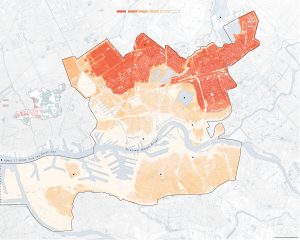
Sources
[40] Nunez, C. (2022, February 15). Sea level rise, facts and information. National Geographic.
https://www.nationalgeographic.com/environment/article/sea-level-rise-1.
[41] Neumann, J. E., Yohe, G., Nicholls, R., & Manion, M. (2000, February). Sea-Level Rise & Global Climate Change: A Review of Impacts to U.S. Coasts. Center for Climate and Energy Solutions. https://www.c2es.org/document/sea-level-rise-global-climate-change-a-review-of-impacts-to-u-s-coasts/.
[42] Adaptation strategies for sea level rise. (n.d.). ERIT: Environmental Resilience Institute Part of the Prepared for Environmental Change Grand Challenge: Indiana University. https://eri.iu.edu/erit/strategies/sea-level-rise.html.
[43] Coping with rising sea levels. (n.d.). World Ocean Review.
https://worldoceanreview.com/en/wor-5/improving-coastal-protection/coping-with-rising-sea-levels/.
[44] Kimmelman, M. (2017, June 15). The Dutch Have Solutions to Rising Seas. The World Is Watching. The New York Times. https://www.nytimes.com/interactive/2017/06/15/world/europe/climate-change rotterdam.html.
[45] Interesting Engineering. (2016, April 9). The Netherland’s Billion Dollar Sea Wall.
https://interestingengineering.com/netherlands-billion-dollar-sea-wall.
[46] History. (n.d.). Dutch Dikes. http://dutchdikes.net/history/ (accessed Apr. 25, 2022).
[47] Patowary, K. (2014, April 19). The Netherland’s Impressive Storm Surge Barriers. Amusing Planet. https://www.amusingplanet.com/2014/04/the-netherlands-impressive-storm-surge.html.
[48] Mulhern, O. (2020, July 28). Sea Level Rise Projection Map – Rotterdam. Earth.Org. https://earth.org/data_visualization/sea-level-rise-by-2100-rotterdam/.
Rising Sea Levels in Saint Petersburg, Florida
Jackson T. Fezell, Aerospace Engineering, Penn State University
Saint Petersburg, Florida is a community in the southern part of Florida. Their location makes them vulnerable to most types of tropical storm. In addition to this, St. Petersburg is a low-lying town that also has a dense population, making it vulnerable to flooding and major damage from the floods. As sea levels continue to rise and the climate continues to get worse, the town will become more threatened by flooding and the problems that come with it. In the current decade, St. Petersburg is predicted to have tidal flooding around 6 days a year. That could increase ten-fold in the following decade. They are currently in the middle of an 18-year tidal cycle where the tidal size is declining. In 2033, the nearly two-decade cycle is expected to turn its course and increase the tidal size, therefore creating more catastrophic effects in the area as the sea level also rises over the next 10 years.
The current problems that St. Petersburg faces from flooding deal with damage to the infrastructure of the town. As the salty water invades the area, it can corrode underground pipes and the pavement used for roads, which are both a very time consuming and expensive fix. The flooding can also damage homes and businesses, along with preventing traffic from getting to certain places. Not only can it damage buildings, but insurance to cover the damages will constantly increase as flooding becomes more frequent. One way the city hopes to deal with the increase in flooding is to install a 24- inch storm pipe under the major roadways that has a valve in it that will allow for retaining more water than normal. Hopefully, the City Council will introduce new zoning areas so that less construction takes place in St. Petersburg. However, they have no intention of doing so due to an increasing population. The construction will disturb and loosen the ground, causing it to be weaker and erode faster. Ultimately, the community will need defenses such as sea walls.
Sources
Koraza, T. (2021, May 15). Experts Warn: St. Petersburg is Facing a Devastating Crisis. NewsBreak. https://original.newsbreak.com/@toni-koraza-561162/2245851012495-experts-warn-st petersburg-is-facing-a-devastating-crisis
Sampson, Z. T. & Rhone, K. (2021, July 19). Sunny day flooding could get a lot worse in St. Petersburg, study shows. Tampa Bay Times.
https://www.tampabay.com/news/environment/2021/07/19/sunny-day-flooding-could-get-a lot-worse-in-st-petersburg-study-shows/
Tara Forde, Political Science, Penn State University
As climate change continues, rising sea levels are increasingly becoming a huge problem for coastal cities. Miami, Florida is one coastal city that is in extreme danger due to rising sea levels. Miami is at a great risk due to porous limestone, dense coastal development, encroaching seas and its low-lying topography (Rhode 2021). Since the 1990s, the sea has risen one foot. To put it into perspective, a rise of two feet will put 10% of South Florida underwater and a rise of five to six feet will displace around 800,000 people when they are forced out of their homes (Dunn 2021). Rising sea levels will displace a large number of people and force many out of their homes. Another danger from rising sea levels is destroying resources Miami relies on like roads, drinking water, and sewer lines. A huge problem within the community is people of lower income communities being forced out of their homes. Many low income and minority communities were forced to high ground away from the beach so wealthier communities could take spots close to the ocean. As sea levels are rising, large construction projects are being planned for wealthier people on higher ground. This in turn may cause gentrification as lower income communities are forced out of their neighborhoods. As for solutions to rising sea levels for the short-term, Miami has begun raising streets, installing pumps, and building sea walls (Dunn 2021). The only problem is they need to focus their money on more long-term solutions, because only investing in short term solutions is not going to help if they will only work for a few decades. A more long-term solution that Miami is looking into is building a massive seawall across Biscayne Bay in downtown Miami (Rhode 2021). There has been a significant amount of uproar about the wall being built due to the possibility of negative impacts on the environment, economy, and quality of life. If Miami is able to use their solutions to prevent rising sea levels, then they could prevent lower income communities being forced out by the wealthy. In the end, Miami must begin to move quickly if they wish to find solutions to rising sea levels or else their community will suffer greatly.
Sources
Dunn, M., Burr, J., & Mims, K. (2021, December 2). Miami Beach and sea-level rise: Flawed infrastructure, environmental injustice, and new opportunities. The Invading Sea. https://www.theinvadingsea.com/2021/12/02/miami-beach-and-sea level-rise-flawed-infrastructure-environmental-injustice-and-new-opportunities/
Rhode, R. (2021, July 28). Sea level rise threatens Miami’s future. here’s how the Army Corps can help keep Florida, Florida. Environmental Defense Fund. http://blogs.edf.org/growingreturns/2021/07/23/sea-level-rise-threatens-miamis-future/
Olivia Friend, Earth Science, Penn State University
The soul of Greenland is said to be the country’s capital and largest city, Nuuk. This particular community is deemed to be rich in diverse cultures and traditions. Nuuk is also known for being encircled by monumental nature, primarily its icy ecosystem. However, over time this aspect has been diminishing rapidly.
Greenland as a country is a major contributor to sea-level rise. This is due to climate change heating the earth’s surface, which melts away glaciers and ice sheets. This melting of additional water drifts into the ocean, boosting the sea’s level. When sea levels rise, coastal communities, such as Nuuk, are highly likely to undergo flooding, destruction of environmental habitats and the animals residing there, and unpredictable weathering for crops. It also doesn’t help that Greenland is home to a large ice sheet. If the entire Greenland ice sheet were to melt, the sea-level (globally) would rise by 7.2 meters, or 24 feet. This significant rise would elevate storm surges due to warmer air and ocean temperatures creating more frequent storms; this, in turn, can cause coastal erosion, flooding of communities, and increased salinity affecting coastal aquifers in Nuuk. Additionally, if the ice continued to melt, less ice would mean that less heat is reflected, producing more heatwaves worldwide. These heat waves can advance the rates at which permafrost melts, exuding unwanted methane gas into our atmosphere, causing temperatures to rise even more, which happens to melt more ice, forming a positive feedback cycle.
As for the community of Nuuk, excluding the possibility of the entire country being underwater besides high mountains, it does bring in large amounts of tourism. More people will be able to travel via boats to sightsee, bringing in excessive money for Nuuk. Additionally, countries such as the U.S. and China are interested in mining for minerals and sand. As the ice cap continues to melt, it pulls more sand and particles offshore, providing an endless amount of sand that can be used for construction material. This could be a massive economic advantage for the community. Even though this may sound good, the constant disturbance to ecosystems makes it unattainable for these environmental systems to bounce back. As more people come into Nuuk, where one-third of the country resides, there is a high potential for traditions and native cultures to dwindle. As more people come to Nuuk, especially by plane, more CO2 gasses are emitted into the atmosphere causing more ice to melt. The cycle seems to be never-ending.
Unfortunately, there aren’t too many ways to solve this problem. We need to cut down our various patterns that contribute to the global temperature increase; this will help slow down the process of global warming. Also, we could find effective ways to help coastal communities and wildlife adapt to these changes. On a bigger scale, we need governments for local communities, states, countries, and continents to come together and tackle this issue at once. However, the first step would be admitting that it’s an issue.
Sources
Chow, D. (2019, September 17). An island imperiled: Climate change threatens Greenland – and its way of life. NBC News. https://www.nbcnews.com/mach/science/island-imperiled-climate-change-threatens greenland-its-way-life-ncna1054921
Duncombe, J. (2021, November 5). Sand from Greenland’s melting ice sheet could bring in business. Eos. https://eos.org/articles/sand-from greenlands-melting-ice-sheet-could-bring-in-business
Hancock, L. (n.d.). Six ways loss of Arctic ice impacts everyone. WWF. https://www.worldwildlife.org/pages/six-ways-loss-of-arctic-ice-impacts everyone
Nuuk. (2021, December 21). Visit Greenland. https://visitgreenland.com/destinations/nuuk/
Person, & Gronholt-pedersen, J. (2021, November 18). Climate-friendly farming: Greenland’s melting glaciers offer an answer. Reuters. https://www.reuters.com/business/environment/climate-friendly-farming-greenlands melting-glaciers-offer-an-answer-2021-11-18/
Villazon, L. (n.d.). Could we live on Antarctica and Greenland if all the ice melted? BBC Science Focus Magazine. https://www.sciencefocus.com/planet-earth/could-we-live-on-antarctica-and-greenland-if all-the-ice-melted/
Olivia Friend, Earth Science, Penn State University
Though it started as a trading ground during the 16th century Renaissance Era, Venice became nothing short of a financial powerhouse. The city of Venice, Italy, was built on top of a lagoon utilizing wood, mud, and minerals. This idea allowed civilization to flourish above the surface of the water. However, as climate change worsens, the future and history of this city might perish faster than we can imagine.
For several years now, the city has been slowly but consistently sinking. Beyond that, the rises in sea level haven’t been helping either. Venice sits on top of the Adriatic tectonic plate which has been shifting to the north, crashing into the Eurasian plate. It is creating a subduction zone as the Adriatic plate is pushed under the Eurasian. This results in the sinking of everything on top of the Adriatic Plate, including Venice. This process is called subsidence, and it causes relative sea-level rise. Additionally, as sea temperatures get warmer, it causes thermal expansion of the water and ice melt, leading to more sea-level rise. Studies have shown that in the years between 1872 through 2000, the sea level has been rising about 2.44 millimeters (+/- 0.15 millimeters) (NOAA). This is comparable to the Mediterranean Sea level rise average of 1.1-1.5 millimeters per year during the past hundred years. These levels are increasing the frequency of floods during high tide events. In the past twenty years, Venice has experienced over one hundred and fifty floods. During these underestimated floods, water seeps into homes and historical buildings. Citizens wear makeshift rain boots to drink coffee at the market and stomp through the water to go to work. The European Geosciences Union predicts that by 2100, Venice will have a sea-level rise of one hundred and twenty centimeters. This number is about fifty percent above the worst-case average for global rising sea levels by 2100. This will lead to many climate refugees searching for places to live while their homes are completely submerged. Additionally, it will lead to the destruction of the history and culture this city holds.
As of today, Venice has built a system full of 78 moveable barriers that are submerged underwater into the seafloor. When floods are predicted, operators will rotate the gates into an upwards position to create a seawall. This temporary wall helps block water from the Adriatic Sea from entering the Venice marshlands. Scientists have claimed for this defense system to work for the next century. It has already been proven successful a handful of times, the most recent being a storm surge in late 2020. However, overuse of these walls could cause a shift in the water quality of the lagoon as well as the alterations of the sediment budget.
Sources
Barry, C. (2021, October 20). Flooding in Venice Is Only Getting Worse. Bloomberg. https://www.bloomberg.com/news/articles/2021-10-20/flooding-in-venice-worsens-off-season-amid-climate-change
Mulhern, O. (2020, June 30). Sea level rise projection map – Venice. Earth.Org – Past | Present | Future. https://earth.org/data_visualization/sea-level-rise-by-the-end-of-the-century-venice/
NOAA. (n.d.). Relative Sea Level Trend 270-054 Venezia (Punta della Salute), Italy. Tides & Currents. https://tidesandcurrents.noaa.gov/sltrends/sltrends_station.shtml?id=270-054
Towey, H. (2021, November 9). See tourists wade through Venice’s flooded squares and cafes as ‘acqua alta’ Tides hit again. Business Insider. https://www.businessinsider.com/venice-floods-pictures-tourists-wade-through-cafes-saint-marks-square-2021-11
Voiland, A. (n.d.). Venice holds back the Adriatic Sea. NASA. https://earthobservatory.nasa.gov/images/149151/venice-holds-back-the-adriatic-sea
Joshua Glass, Security and Risk Analysis, Penn State World Campus
As a current resident of the tidewater region of southeastern Virginia, flooding due to sea-level rise (SLR) has become a major concern for residents as climate change has taken its toll. This fact led me to purchase a home on one of the highest elevated areas in my community, at a measly 16 ft above sea level. The crisis of rising sea levels certainly has an effect on my own community, but the effects are felt significantly more in a historic island community just 50 miles north of my home in Virginia Beach. This is the tragedy of the sinking island of Tangier. Tangier, an island community with less than 500 inhabitants, has a significant historical importance to Anglo history. The island is home to the Tangier accent, which is the unadulterated accent spoken by the original settlers from England. Both the American and British accents on the mainland have changed over the centuries, but this community has maintained the original accent spoken in the 17th century and is quite literally living history. But, this low-lying historically significant community is threatened by the rising waters in the Chesapeake Bay. According to Wu and Schulte of Biogenic Solutions Consulting, LLC, a loss of land of 32.8 to 12.5 hectares has been measured on Tangier from 1967–2019. Furthermore, they indicate the trend to be accelerating over time, with complete conversion to wetlands predicted by 2051. (Wu & Schulte, 2021). Schulte specifies that the loss of land since 1850 is currently at 66.75 percent, and the future impacts will lead to the first climate change refugees in the continental US.
The root cause of this loss of land is due to the rise of the Global Mean Sea Level, and the Intergovernmental Panel on Climate Change (IPCC) has declared “Human influence [sic] as the unequivocal main driver of these SLR increases since at least 1971” (Stocker, 2014). Since human influence is the cause of this tragedy, the only way to reverse this tragedy would be human intervention. Wu and Schultze estimate the cost of this intervention to be substantially high, at 250-350 million dollars (Wu & Schulte, 2021). This price tag includes interventions such as constructing a stone seawall to fight future erosion and to increase the elevation of the island by dredging sand ashore from the bay. The choice to save or abandon Tangier is a choice that still rests with US policy makers. A choice that may well be a harbinger of future policy decisions for coastal US communities if climate change continues unchecked.
Source
Wu, Z., & Schulte, D. (2021, November 8). Predictions of the climate change-driven exodus of the town of Tangier, the last offshore island fishing community in Virginia’s Chesapeake Bay. Frontiers. https://www.frontiersin.org/articles/10.3389/fclim.2021.779774/full
Stocker, T. (Ed.). (2014). Climate change 2013: the physical science basis: Working Group I contribution to the Fifth assessment report of the Intergovernmental Panel on Climate Change. Cambridge university press.
Nicholas Guzman, Biochemistry and Molecular Biology, Penn State Eberly College of Science
Sea level rise due to climate change has, and will continue to, primarily affect coastal land regions, especially those with very low elevations above sea level. Bangkok is the capital and most populated city in Thailand and is located along the Chao Phraya River delta in central Thailand. The average elevation of Bangkok is currently only 1.5 meters above sea level (Bangkok, 2022). Revised estimates by climate scientists have predicted that approximately 10% of Thailand’s residents who live along the low-lying terrains of Bangkok will be displaced by the year 2050, which is about seven million people (New York Times, 2019). Unfortunately, Bangkok is a major port city and the financial and cultural hub for Thailand, so the loss of this land due to sea level rise would have dire effects on the economy and culture of the entire country. This is not just a future problem, as the city has been facing an onslaught of frequent flooding (Bangkok, n.d.). To combat this, the city has embarked on multiple infrastructure projects. One example is the creation of parks in Bangkok to act as ‘green basins’, which funnel floodwater into underground tanks. However, the problem then arises of finding enough room to store all of the water, and future work on projects like these is being slowed down due to the city’s focus on urban development (Ng & Desmond, 2020). All of this development is only adding fuel to the fire as subsidence is causing the land to sink at a rate of up to two centimeters each year. Citizens of Bangkok are not content with how the government is prioritizing urban development over the existence of canals and proper waterways and believe that the only way to save the city is for the community and lawmakers to make decisions together. This is not a problem faced by the entire country of Thailand, as land surrounding Bangkok to the north, east and west is situated at a much higher elevation (with an average elevation of 187 meters). Therefore, it is likely that we will see a mass migration of the population of Thailand out of Bangkok and into regions of higher elevation by the year 2050.
Sources
Bangkok. (2022, April 4). In Wikipedia. https://en.wikipedia.org/wiki/Bangkok
New York Times. (2019, November 2). Revised forecast puts Bangkok underwater by 2050. Bangkok Post. https://www.bangkokpost.com. https://www.bangkokpost.com/thailand/general/1785569/revised-forecast-puts-bangkok-underwater-by-2050
Bangkok. (n.d.). Encyclopædia Britannica. https://www.britannica.com/place/Bangkok
Ng, D. & Desmond N. (2020, March 19). The fight to save Bangkok from sinking into watery depths. CNA. https://www.channelnewsasia.com/cnainsider/fight-save-bangkok-sinking-watery-depths-floods-climate-change-1338826
Jason Langland, Architectural Engineering, Penn State University
Rising sea levels will have profound global impacts over the next century, but not every region will experience sea level rise equally. Low lying Pacific islands are especially susceptible to rising sea levels due to very low land elevations and small land areas. The current average rate of sea level rise globally is between three and four millimeters per year, but Suva’s coastline is disappearing at an alarming six millimeters per year, since 1993. Suva is a city on the south coast of Fiji’s largest island, Viti Levu, and is home to almost one hundred thousand people. Suva, and Fiji as a whole, is almost entirely reliant on tourism to support the local economy. Resorts and cruise ships are commonplace in the city, but the effects of beach erosion due to sea level rise coupled with increasingly severe cyclones are beginning to be felt amongst the population. Sea level rise around Suva has also led to saltwater intrusion in agriculture areas. More than fifty percent of Suva is below 15 meters above sea level, and the majority is closer than that.
Fiji has been a very active member of the UN Climate Change Conference and was the first nation to ratify the Paris Agreement. On a national level, Fiji has launched an adaptation plan that addresses issues of sustainable development and commits to help communities such as Suva with relocation of the population. Fiji has also released a Climate Vulnerability Assessment and Green Growth Plan both of which promote and apply policies that protect the island nation. According to their assessment, more than forty communities are already recommended for relocation. Suva’s economy relies heavily on massive cruise ships that stop to the city bringing tourists, however, it is clear the people of the city and nation wish to protect their shoreline from the rising sea. It is a similar situation with many of the Pacific Island nations- they are not large carbon dioxide polluters, but their people will feel the effects of warming the most. This may deal a drastic blow to the livelihoods of citizens, but the people of Suva are actively engaging in politics which will protect their coastlines and community.
Sources
Gupta, A. (2018, November 10). Sea level rise is forcing Fiji coastal villages to relocate. CGTN. https://news.cgtn.com/news/3d3d774e78597a4e7a457a6333566d54/share_p.html
Belson, K. (2018, October 24). Paradise Threatened: Fiji’s War Against Climate Change. The New York Times. https://www.nytimes.com/2018/10/24/travel/fiji-global-warming.html
How Fiji is Affected by Climate Change. (2017). Cop23. https://cop23.com.fj/fiji-and-the-pacific/how-fiji-is-affected-by-climate-change/
Sea Level Rise in New Orleans, Louisiana
Katelynn MacPherson, Psychology, Penn State World Campus
A community at a particular risk of sea level rise are those living in New Orleans, Louisiana. Losing land at an alarming rate, coastal Louisiana is uniquely threatened not only because of the rising sea level but because these communities were built on drained marshland that is slowly sinking. Projections estimate that increased flooding, more frequent and intense storm events, and impacts to fisheries are highly likely throughout the 21st century (NRDC, 2011).
New Orleans is vulnerable for a number of reasons: low elevation, high land subsidence rates, and a history of overdevelopment. In the late 1800’s, the Army Corps of Engineers began building walls and levees along the Mississippi River to control the flooding of the wetlands of Louisiana. This allowed the state to build homes, establish communities, and use the river for trade (Teirstein, 2021). However, these dams keep the river from depositing sediment into the surrounding land and the coastline is now disintegrating into the ocean. Additionally, these coastal communities like New Orleans are even more vulnerable to hurricanes and storm surges. Current projections estimate that by 2050 Louisiana could lose a third of its coastlines (Teirstein, 2021), destroying marshland habitats and forcing millions of individuals to migrate, with 500,000 vacating New Orleans (Baurick, 2021).
Measures like establishing a new seawall system, more efficient pumps, and the elevating of homes are proposed solutions to the threat of sea level rise in New Orleans. However, these plans are costly with estimates over $50 billion for a 50 year plan to address Louisiana’s coastlines (Baurick, 2021). The city has already done a lot to try to mitigate this problem. New Orleans has developed a Comprehensive Zoning Ordinance project to control construction of new developments with sustainable and flood resistant designs (NRDC, 2011).
The Louisiana government in combination with funding from the BP oil company have established the Mid-Barataria Basin Diversion. The plan is to strategically flood the Mississippi in an attempt to restore the land in the marshes surrounding New Orleans (Teirstein, 2021). However, the introduction of more freshwater will negatively affect communities that depend on oyster and shrimp farming, while also threatening the dolphins living in the bay (Teirstein, 2021). In this situation the benefits outweigh the costs on a larger scale, as the land loss will continue and threaten the floodgates and levees of New Orleans that were not designed to defend the city from severe storm events without the surrounding marshes as a first line of defense (Teirstein, 2021). Sea level rise will continue to be a growing problem for the city of New Orleans in the future.
Sources
Baurick, T. (2017, April 21). Rising sea to displace 500,000 New Orleans area residents, study says; see where they might go. NOLA.com. https://www.nola.com/news/environment/article_f87ed4a5-ffe7-5108-810e a1bc775b47e9.html
NRDC. (2011, July). New Orleans, Louisiana: Identifying and Becoming More Resilient to Impacts of Climate Change. nrdc.org/policy. https://www.nrdc.org/sites/default/files/ar-section-h-i.pdf
Teirstein, Z. (2021, March 17). ‘there’s no alternative’: Louisiana’s ambitious plan to stay above water. Grist. https://grist.org/climate/theres-no alternative-louisianas-ambitious-plan-to-stay-above-water/
Rising Sea Level in Hunting Island, South Carolina
Tim Mykulyn, General Biology, Penn State University
Perhaps one of the most infamous and well known challenges of climate change is its impact on sea levels and its contribution to sea level rise. Many coastal cities and communities around the world face the threat of being inundated with rising sea water that current infrastructure is unable to adapt to. The United States in particular is home to many communities that face such a dilemma, such as Hunting Island, South Carolina.
The island is a barrier island off the coast of South Carolina that is largely made up of a state park meant to protect its unique subtropical environment. Most of the island is less than ten feet above sea level and there are very small portions that even reach above thirty feet. Being so low, increasing sea levels have massively changed the landscape of the park and island.
One of the most apparent impacts of rising seas on the island is its impact on the local flora and fauna. Every type of vegetation on the island is carefully adapted to a specific level of salinity in the water, and as sea levels rise the salinity of water inland increases. Across the island massive die offs of native flora have occured due to rising tides. Rising sea levels have also negatively impacted development in the area. The mixing of sea water and fresh water sources have also impacted local fisheries, having a negative impact on local communities that rely on them economically.
In the near term temporary measures have been taken to be able to remove areas with standing water on the island. State agencies in South Carolina have worked to reverse damage done by development, specifically targeting artificial sand dunes that have worked to help collect water inland into standing pools. Beach reclamation is also being used and in the state of South Carolina to raise land against a rising sea.
In the long term there are not many options to save the island in its familiar state. Engineering projects to be able to build tide breaks and prevent the shifting of the island have been considered and instituted in other barrier islands to some success. Another solution is to simply reduce the amount of development that occurs in the area to minimize the loss to floodwaters. Many states have undertaken these efforts to reduce the amount of development in these areas through zoning laws.
Sources
Costley, D. & Borenstein, S. (2021, November 12). Vulnerable US Communities Consider ‘Managed Retreat’ from Rising Waters of Climate Change. Anchorage Daily News. https://www.adn.com/nation-world/2021/11/12/vulnerable-us-communities-consider-managed-retreat-from-rising waters-of-climate-change/.
Holleman, J. (2020, October 21). First Impacts: Natural Systems Face Sea-Level Rise. Coastal Heritage Magazine. https://www.scseagrant.org/natural-systems-face-sea-level-rise/.
Gordemer, B. (2021, November 7). Rising Sea Levels Threaten the Lives and Livelihood of Those on a Fragile U.S. Coast. NPR. https://www.npr.org/2021/11/07/1051529051/rising-sea-levels-climate-change-south carolina-coast.
Matheny, C, G. Burns, J. G. Titus, A. Hickok, & Hudgens, D. E. (2010). The Likelihood of Shore Protection along the Atlantic Coast of the United States. Volume 2: New England and the Southeast. Report to the U.S. Environmental Protection Agency. Washington, D.C.
Tibbetts, J. H. (2019, October 25). Sea-Level Rise: Adapting to a Changing Coast. Coastal Heritage Magazine. https://www.scseagrant.org/sea-level-rise-adapting-to-a-changing-coast/.
Shoreline Change Initiative. (n.d.). South Carolina Department of Health and Environmental Control. https://scdhec.gov/environment/your-water-coast/ocean coastal-resource-management/shoreline-change-initiative.
Smith, J. P. (2020). The Shell Builders: Tabby Architecture of Beaufort, South Carolina, and the Sea Islands. South Carolina Libraries, 4(2). https://doi.org/10.51221/sc.scl.2020.4.2.5.
Young, R. S. (2021, May 5). Newsbyte. Beaufort South Carolina The Island News. https://yourislandnews.com/we-have-to-change-how-we-use-hunting-island/.
Forrest Steele, Electrical Engineering, Penn State University
When discussing the threat of rising sea levels because of the melting ice caps, it is crucial to mention Miami. As one of the more populated coastal cities in the U.S., town officials have already begun preparing for the worst. With the threat of a high sea level, Miami continues to face more extreme weather events especially that of flooding and more damage from hurricanes.
Miami resides in southern Florida and has a very low altitude as it borders on the Atlantic Ocean. Another environmental challenge is that Miami is also built on porous limestone. When the water rises, it causes salt water to surge up from underground in extreme events. This goes on to do more damage to infrastructure and cause saltwater to mix with freshwater sources.
Due to this, Miami is one of the communities where rising sea levels pose a great threat to the infrastructure and the population of the city. It is estimated that by 2030, the sea level could rise by over 6 inches. This puts a massive amount of the coastal areas in Miami under threat. This is particularly dangerous as some of these areas are low-income communities, meaning they are struggling to get the help they need to prepare for extreme weather events.
Unfortunately, for threats like these, there are not too many solutions, and all of which are very expensive. The US Army Corps of Engineers has proposed building a ‘seawall’ along downtown Miami. This seawall acts as a concrete barrier to protect the city from the rising sea levels and mitigate damage from extreme weather events. Other proposals include more natural options such as implementing more local flora. Coral reefs and mangrove trees have proven to be just as effective as some of the more infrastructure-based solutions while preserving the view of Miami coastline and at a fraction of the price. Miami-Dade County has also begun preparing for when infrastructure inevitably sinks due to rising sea levels and has begun building low-cost housing on higher grounds. This serves as a last-resort option for the lower-income communities directly along the ocean. Miami is one of the many coastal communities that are under direct threat of the rising sea levels, and plans on preparing for the worst.
Sources
Ariza, M. A. (2020, September 29). As Miami Keeps Building, Rising Seas Deepen Its Social Divide. Yale Environment 360. e360.yale.edu/features/as-miami-keeps-building-rising-seas-deepen-its social-divide
Alexanyan, K. (2021, November 22). From Greenland to Miami, How Rising Sea Levels Impact Coastal Communities. Columbia University Data Science Institute. datascience.columbia.edu/news/2021/from-greenland-to-miami-how-rising-sea-levels-impact-coastal-communities/
Rhode, R. (2021, July 23). Sea level rise threatens Miami’s future. Here’s how the Army Corps can help keep Florida, Florida. Environmental Defense Fund. blogs.edf.org/growingreturns/2021/07/23/sea-level-rise-threatens-miamis-future/
Cambridge, MD (Sea Level Rise)
Allison Welch, Earth Sciences, College of Earth and Mineral Science, Penn State University
Sea level rise is having an impact on coasts across the planet threatening coastal communities. In Maryland specifically, the flooding of coastal areas is being caused by subsidence. This is an issue all around the United States and it’s caused by water from aquifers being over-pumped for human use. As the water leaves, the ground sinks, causing sea levels in that area to rise. Water levels in the Maryland and Virginia aquifers have declined more than 170 feet below sea level, causing a 1.5 to 3.7 millimeter per year land subsidence (Land Subsidence..., n.d.).
Maryland is particularly vulnerable because of the groundwater withdrawn of the Patapsco and Patuxent aquifer systems. Cambridge sits on the Eastern Shore of Maryland sandwiched between the Potomac River and the Atlantic Ocean. This area is part of the coastal plain region of Maryland that houses aquifers thanks to the sand and gravel composition of the soil (Aquifers in Maryland, n.d.). As water leaves the aquifers, land above sinks. Now Maryland is facing a sea level rise of about 1 inch every 5 years and a projected 12 inches of sea level rise from 1990 to 2031 (Maryland’s Sea…, n.d.). This paired with the increase of storms, erosion, and sea level rise due to climate change causes a big flooding problem for these coastal communities.
In Cambridge, residents who rely on the land to make a living are being affected by increased floods. Paul Jackson, a seventh-generation farmer on the Eastern Shore is facing land that has become useless due to salt water from flooding of the nearby Little Choptank River. Farmers like him have tried solutions like putting down gypsum to absorb the salt, but another flood will come and wash it away, wasting money. Schools in Cambridge have had to get out early because the tides would be too high to run the school buses at dismissal. Police stations, hospitals, and other necessary buildings are going to have to be moved to the highest parts of the town to make sure they are accessible during regular flooding (Miller, 2022). This sea level rise is detrimental for the city and is already causing substantial financial repercussions. Without a solution, the town will eventually go underwater as the sea level continues to rise and the area continues to sink.
The state and local governments are already working towards solutions to this issue. The Atlantic Coast of Maryland Shoreline Protection Project was granted $15.7 million to replenish the beach and shoreline that is eroded away every year by hurricanes and coastal storms (Soper, 2021). In Annapolis, MD there is a flood mitigation project in place that will include a new pump station, realignment of existing storm drainage systems and construction of a new bulkhead (Stormwater and…, n.d.). The future for all climate related issues is unknown but with these plans (and more) in place the future is brighter for the Eastern Shore of Maryland.
Sources
Aquifers in Maryland. (n.d.). Maryland Geology Survey. http://www.mgs.md.gov/groundwater/md_groundwater.html
Land Subsidence Monitoring Network. (n.d.). Maryland Geology Survey. http://www.mgs.md.gov/groundwater/current/land_subsidence.html
Miller, J. (2022, April 22). Rising sea levels, erosion — already impacting Maryland — expected to worsen in next 2 decades. WBAL. https://www.wbaltv.com/article/rising-sea-levels-maryland-worsen-next-2-decades/39777503#
Maryland’s sea level is rising. (n.d.). SeaLevelRise.org. https://sealevelrise.org/states/maryland/
Soper, S. (2021, August 5). 08/05/2021: Replenishment set in Ocean City: News ocean city MD. News Ocean City Maryland Coast Dispatch Newspaper. https://mdcoastdispatch.com/2021/08/05/replenishment-set-in-ocean-city/
Stormwater and flood mitigation project. (n.d.). Stormwater and Flood Mitigation Project | Annapolis, MD. https://www.annapolis.gov/1783/Stormwater and-Flood-Mitigation-Project.
Ashley Wrabel, Communications, Penn State University
The threat is the rising sea level, affecting the city of Bangkok in Thailand. One area that especially receives flooding is Bangkok’s Chinatown, which gets overflow from the Chao Phraya River. Bangkok is a low-lying city and has an elevation of just 1.5 meters above sea level. The city has some roadways that are built over filled canals and the city lies on a swampland. The city is experiencing the threat of major flooding, with stronger storm surges, runoff, and ice sheets melting. The city’s excessive extraction of groundwater is also causing subsidence, which can contribute to the flooding.
The community is vulnerable because the flooding is persistent. Many people are losing homes, and infrastructure is being ruined. In Bangkok’s China town, a flood in October of 2011, which was a horrible year for flooding all over Bangkok, flooded roads, parking lots, and markets. During this flood, many people had to flee to the Suvarnabhumi Airport in order to get to dry land. The city’s low lying lands and citizens who may not be able to afford to rebuild make the community vulnerable.
The forecasted impact on the community is that the sea level is expected to rise 1-2 meters, and by the end of the century, most of the city of Bangkok will be underwater. It was also estimated that 5 out of the 10 million people living in Bangkok would be exposed to flood risk by 2070 (Mulhern, 2020). Bangok is basically a sinking city, and much of the water contributing to the floods is coming up from the ground.
There are a couple of solutions to the threat of sea-level rise in Bangkok. The city needs to create better overall water management systems. This includes diverting water away from the city or even adding green spaces like gardens or green roofs in order to help divert the runoff water. It also would be efficient to improve the warning systems, so that people know when major floods may be coming. Sadly, with the current rate of sea-level rise, most of the city will have to migrate. Those that can afford it may be able to turn it into a water-based city, or implement boathouses, but for the majority, the solution may be migration.
Sources
Basu, M., & Olarn, K. (2011, October 28). High tide brings flooding to Bangkok’s chinatown. CNN. https://www.cnn.com/2011/10/27/world/asia/thailand-flood/index.html
Marks, D. (2021). Short and long- term solutions for Bangkok’s every growing vulnerability to floods and other climate risks. Henrich Büll Stiftung. https://th.boell.org/en/2021/11/01/short-long-term-solutions-bangkok-flood
Mulhern, H. (2020). Sea level rise protection map – Bangkok. Earth.org. ttps://earth.org/data_visualization/sea-level-rise-by-the-end-of-the-century bangkok/
Win, T. (2017). Bank struggles to protect slum dwellers as floods worsen. Thomsen Reuters foundation. https://www.reuters.com/article/us-thailand-floods-bangkok/bangkok-struggles-to-protect-slum-dwellers-as-floods-worsen-idUSKBN19A0KL
Joshua D. Contreras, Economics, Penn State University
The Sameby people, a reindeer herding populace, are a part of the Sami population located in the Sapmi region which extends from Norway to Russia. They are on the verge of becoming completely disrupted in their way of life due to green colonialism and climate change, mainly the rapidity of melting ice within the Arctic. Green colonialism is when foreign/indigenous lands are seized for environemental conservation purposes. The Sameby people have lived within the Sapmi area for the past 10,000 years and have survived harsh winter conditions due to their efficient hunter gather and reindeer husbandry traditions. Their sources of food come from an array of livestock which includes moose, seals, walrus, fishes, and crab. But their main source of survival has always been the reindeer population that have freely roamed the local area.
Due to human expansion in the region the reindeer habitat that had been previously undisturbed has shrunk by seventy percent. This is due to the current green colonialism that is occurring in the Swedish area of the Sapmi region. Forests and land have been taken from the Sami people to make room for hydroelectric dams, wind farms, and mines. Because of the modernization in the area the reindeer populations have become such a focal point for the region that the Swedish government had to become involved and only authorize the Sameby, the right to engage in reindeer husbandry.
Green colonialism is not the only threat to the reindeer in the region. The animals are also dying off from the warmer temperatures that are encroaching in the arctic circle. Reindeer can no longer obtain their food source from the snow as they once did because the snow is now turning to rain which freezes over their precious food source. Not only is there less food for the animals because of the effects of climate change it is also becoming less nutritious. The ice that forms from the rainfall makes it increasingly difficult for the reindeer to gather food which has led to periods of mass starvation for the animal the Samby have such a close relationship with.
To assist the plight of the Sameby people it will take efforts on a global scale. Keeping our nations’ leaders to the goals and mission statement set forth within the Paris Climate Agreement is an effective way that we, as a global community, adhere to the two degrees centigrade goal. At the micro level, we need to invest in shrinking our carbon footprint by finding renewable energy resources whether it be driving a car with electric functionality, limit or recycle our waste, or even consuming seasonal or less food.
Sources
(2019). The Sami Arctic Strategy.
Arctic and environmental unit. Sámiráđđi. (n.d.). https://www.saamicouncil.net/en/arctic-and-environmental-unit
Kater, L. (2022, May 11). Mass starvation of reindeer linked to climate change and habitat loss. The Conversation. https://theconversation.com/mass starvation-of-reindeer-linked-to-climate-change-and-habitat-loss-121452
Nellemann, C., Vistnes, I., Jordhøy, P., Strand, O., & Newton, A. (2003). Progressive impact of piecemeal infrastructure development on Wild Reindeer. Biological Conservation, 113(2), 307–317. https://doi.org/10.1016/s0006-3207(03)00048-x
Unfccc.int. (n.d.). https://unfccc.int/process-and-meetings/the paris-agreement/the-paris-agreement
Ice Melt In General MacArthur, Philippines
Nicole Meek, Plant Science: Agroecology, Penn State University
Glacial ice is melting faster now than it has in thousands of years. Scientists studying the issue have determined that the ice is not only melting because the temperature in the atmosphere is increasing, but also because the ocean is acting as a sink and absorbing more energy. This increases the overall temperature of the water, which affects many things including life in the ocean and the glaciers in it. The glacial melting alone is causing the sea level to slowly rise, and this issue is compounded by the fact that the warmth causes an increase in fractures and cliff failures in the glaciers (Hansen et al., 2016). Scientists have shown through models that the additional considerations of these factors greatly increase the speed at which the glacial ice melts, and could cause a major collapse in the stability of the ice within the next few decades (Pollard et al., 2015). The Thwaites glacier is an example of the ice in Antarctica that scientists are deeply concerned about, due to its instability and the fact that it alone could increase the sea level by over two feet (Bralower, 2022).
Many places around the world will be impacted by the increase in sea level, but especially coastal areas and places that are already prone to flooding. The Philippines are extremely vulnerable to impacts from rising sea levels due to the sheer amount of coastline and islands the country has, along with the fact that many of the major cities such as Moalboal, Iloilo, and Cebu are on the coast and low-lying. General MacArthur is a town in Eastern Samar, with a population of about 14,500 people. Eastern Samar has one of the highest poverty rates in the country, and the town of General MacArthur has the highest percentage in that area at 53.8 (Ordinario, 2015). This makes the people living here especially vulnerable, because many of them would not have the money or resources necessary to move when the ocean starts to rise. While the threat of the sea level might not affect the people living in the town currently, it will certainly impede on the lives of the future generations, who may face displacement by force of nature and have nowhere to go if the detrimental trend of poverty in the area continues (General MacArthur, , 2022).
Shown below are three maps describing what parts of the land are below water level at various increases in the sea level. With no rise in sea level, very little space gets flooded, unless there is a storm surge or extreme tide. The top map shows how much land (in red) would be submerged in water if the sea level rises by two feet, the middle map displays the scenario if it rises by four feet, and the bottom shows how much space would be underwater if the sea level increases by eight feet (Costal Risk Screening Tool: Water Level, 2022). The extent to which the land is covered with water after the sea level increases is much more dramatic than other areas seen around the world. This threat, along with the presence of extreme poverty, make the people living in General MacArthur very vulnerable to the implications of climate change. On a worldwide level, the best thing we can do is try to decrease the amount of global warming that is projected, by choosing more sustainable energy sources and reducing the amount of pollution and carbon that we emit. Ultimately, the more we do now, the less the glaciers will melt. Then, if the glaciers don’t melt as much as predicted, then the sea level wouldn’t rise as much either. In terms of the community itself, they along with many other poor coastal towns need to be supported more by their government, so that their rates of poverty decrease and they become more financially stable. Then, they would be capable of taking action if they need to, when the tide comes in.
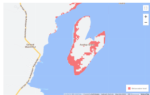
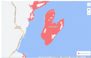
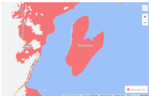
Image source: Costal Risk Screening Tool: Water Level. (2022). Climate Central, Inc. https://coastal.climatecentral.org/
Sources
Bralower, T. (2022). Greenland and Antarctic Ice Sheets. Penn State University.
Costal Risk Screening Tool: Water Level. (2022). Climate Central, Inc. https://coastal.climatecentral.org/
General MacArthur, . (2022). Eastern Samar Profile ; PhilAtlas. https://www.philatlas.com/visayas/r08/eastern-samar/general-macarthur.html
Hansen, J., Sato, M., Hearty, P., Ruedy, R., Kelley, M., Masson-Delmotte, V., Russell, G., Tselioudis, G., Cao, J., Rignot, E., Velicogna, I., Tormey, B., Donovan, B., Kandiano, E., von Schuckmann, K., Kharecha, P., Legrande, A. N., Bauer, M., & Lo, K.-W. (2016). Ice melt, sea level rise and superstorms: Evidence from paleoclimate data, climate modeling, and modern observations that 2 °C global warming could be dangerous. Atmospheric Chemistry and Physics, 16(6), 3761–3812. https://doi.org/10.5194/acp-16- 3761-2016
Ordinario, C. (2015, January 6). Poorest town posts 84.8% poverty incidence rate, PSA survey shows | Cai Ordinario. BusinessMirror. https://businessmirror.com.ph/2015/01/06/poorest-town-posts-84-8-poverty-incidence-rate-psa survey-shows/
Pollard, D., DeConto, R. M., & Alley, R. B. (2015). Potential Antarctic Ice Sheet retreat driven by hydrofracturing and ice cliff failure. Earth and Planetary Science Letters, 412, 112–121. https://doi.org/10.1016/j.epsl.2014.12.035
Snow Melt and the Oroville Dam
Anthony Sadler, Economics, Penn State University
In February 2017, there was an unexpected amount of snow and ice, which melted and overwhelmed the Oroville Dam in Oroville, California. The amount of excess water almost breached the uppermost part of the dam (Fudge, 2022). Many scientists attribute this unusual amount of runoff to events within its watershed, including the redirection of atmospheric rivers caused by climate change (Fudge, 2022). As a background, these atmospheric rivers are narrow, horizontal precipitation bands which deposit large amounts of rain (or snow) while stalled over watersheds (NOAA, 2022). In the case of the Oroville Dam, the threat proceeded in two phases. It started with the accumulation of snow in the Sierras, followed by rain, leading to large volumes of snowmelt (Fudge, 2022).
During moments of overflow, the vulnerability of the downstream communities is obvious, with catastrophic flooding hazards should the dam break. Although the dam didn’t break during this event, it doesn’t mean the structural fortification will be enough if needed in the future. During 2017, approximately 188,000 people needed to be evacuated downstream because of the water being held back in Oroville Lake which was artificially created through the damming of the Feather River (Michaelis et al., 2022). Although the area is currently experiencing a drought, experts warn that climate change is making the movement of these atmospheric rivers unpredictable and perhaps deadly to the area (Michaelis et al., 2022).
The dam’s functionality showcases the future impact on the community including its ability to serve as a large hydroelectric dam, water supply, flood control, and even an important fish hatchery (Feather River..., n.d.). Even though the watershed of the dam is only 360 square miles, the dam’s destruction could be disruptive to many facets of life in the area. This includes both the economic viability and livability of the area within the Sacramento Valley (Oroville Reservoir…, 2018).
Solutions have been focused on both the assessment and redesigning of the dam during a variety of atmospheric scenarios. Because of the $1 billion dollar price tag during the 2017 crisis, there has been significant modeling of both the probability of atmospheric river incursions and what to do when one stalls over the watershed (Michaelis et al., 2022). Additionally, there has been the talk about re-enforcing the engineering infrastructure of the dam including additional emergency spillway with modernize sensor equipment such as flowmeters, piezoelectric movement detectors, etc. (Hutchison, 2022).
Sources
Feather River Fish Hatchery. (n.d.). CDFW, https://wildlife.ca.gov/Fishing/Hatcheries/Feather-River.
Hutchison, J. (2022, February 13). Oroville Dam Crisis 5 Years Later: Spillways Rebuilt. The Mercury News. https://www.mercurynews.com/2022/02/12/oroville-dam-crisis-5-years later-spillways-rebuilt-lawsuit-in-appeals-court/.
Lower Feather River Watershed. (n.d.). Sacramento River Watershed Program, https://sacriver.org/explore watersheds/feather-river-subregion/lower-feather-river-watershed/.
Michaelis, A. C., Gershunov, A., Weyant, A., Fish, M. A., Shulgina, T., & Ralph, F. M. (2022). Atmospheric River Precipitation Enhanced by Climate Change: A Case Study of the Storm That Contributed to California’s Oroville Dam Crisis. Earth’s Future, 10(3). https://doi.org/10.1029/2021ef002537.
NOAA PSL. (2022). About Atmospheric Rivers. About: AR Portal at NOAA Physical Sciences Laboratory. https://psl.noaa.gov/arportal/about/.
Oroville Reservoir and Thermalito Facilities. (2018, May 11). Northern California Water Association. https://norcalwater.org/efficient-water-management/efficient-water-management-regional sustainability/water-maps/oroville/.
Fudge, T. (2022, March 8). San Diego Research Links Oroville Dam Crisis to Global Warming. KPBS Public Media.
https://www.kpbs.org/news/local/2022/03/07/san-diego-research-links-oroville-dam-crisis-to global-warming.
Saltwater Intrusion in Hilton Head
Anthony Sadler, Economics, Penn State University
One of the most problematic, albeit secondary, aspects of sea level rise is the composition of the water that rushes ashore, rather than the quantity. As sea level rises, many cities and towns around the eastern seaboard are expected to experience the reality of changing water tables at once-secure freshwater locations (Richter, 2022). Even the seemingly relaxing location surrounding Hilton Head, prizing itself on pristine resort conditions and golf courses, will be no match for the rising sea levels and ever changing water tables (Richter, 2022).
This intrusion is essentially the aggregate and forward movement of saltwater into a freshwater system due to the rise in sea level (Richter, 2022). In conjunction with increased storm surge from stronger storms, the salt water will also be deposited farther upstream and have a decreased ability to be removed from inland areas (Richter, 2022). Over time, the increase in salt content will lead to health problems in humans and animals, including hypertension, high blood pressure, and kidney disease (Paolo & Khan). Additionally, increased salinity will interfere with the ability of crops to uptake water through a destructive process called the toxic ion effect (Betzen et al., 2019).
Outside of the ability to provide safe drinking water, Hilton Head will find itself at the crux of a dilemma on how to balance the economic viability of its community with the anticipated increase in freshwater salinity. Hilton Head has already been forced to abandon six of the original twelve wells on the island by local water districts (Richter, 2022). The closing of these wells will force the community to prioritize the needs of the area. It is well known that a significant amount of freshwater is drawn up due to economic factors such as tourism, golf courses, etc. (Payne, 2010).
Future projections of the areas have calculated that the encroachment of saltwater has moved approximately 400 feet per year (Richter, 2022). Therefore, without additional support in controlling the freshwater table, it is forecasted that five more wells will be unusable by 2024 (Richter, 2022). In fact, sea level rises aren’t the only thing contributing to the increased salinity of the Hilton Head water table. Even if significant controls are maintained on sea level, it is still projected that salinity will increase due to the population increase within the Upper Florida aquifer (Payne, 2010).
To help counter these problems with coastal contamination of the freshwater table, there have been numerous projects planned using desalination with reverse osmosis (Earth Tech…, 2007). This process uses a semi-permeable membrane to separate water and salt molecules, producing “pure” water and discharging more concentrated salt brine. Because of Hilton Head’s future needs, there are future plants being built by a company called Earth Tech Inc., in conjunction with the Hilton Head Public Service District (Earth Tech…, 2007). This new desalination plant will produce 3 million gallons of water from brackish water within the Middle Florida Aquifer each day with the ability to double capacity should the need arise (Earth Tech…, 2007).
Sources
Betzen, B. M., Smart, C. M., Maricle, K. M., & Maricle, B. R. (2019). Effects of Increasing Salinity on Photosynthesis and Plant Water Potential in Kansas Salt Marsh Species. Transactions of the Kansas Academy of Science, 122(1-2), p. 49., https://doi.org/10.1660/062.122.0105.
Earth Tech to Build Desalination Plant for South Carolina Community. (2007). Water and Wastes Digest. https://www.wwdmag.com/home/news/10911820/earth-tech-to-build-desalination-plant-for south-carolina-community.
Payne, D. F. (2010). Effects of Sea-Level Rise and Pumpage Elimination on Saltwater Intrusion in the Hilton Head Island Area, South Carolina, 2004-2104. U.S. Department of the Interior, U.S. Geological Survey. https://www.usgs.gov/publications/effects-sea-level-rise-and-pumpage elimination-saltwater-intrusion-hilton-head-island.
Richter, H. (2022, August 2). Saltwater Intrusion, a ‘Slow Poison’ to East Coast Drinking Water. Water News, Circle of Blue. https://www.circleofblue.org/2022/world/saltwater-intrusion-a-slow poison-to-east-coast-drinking-water/.
Vineis, P. & Khan, A. (2012, Nov 23). Climate Change–Induced Salinity Threatens Health. Science. https://www.science.org/doi/10.1126/science.338.6110.1028-b.
Chanyoung Bhang, Penn State University
Miami, located in South Florida, is considered one of the most vulnerable cities in the world to sea level rise. Along with its low elevation, Miami is also facing a faster rate of sea level rise compared to other regions. According to scientific projections, the sea level in Miami could rise by as much as 6 feet by the end of the century, which is higher than the global average due to various factors, including subsidence and changes in ocean currents.
The forecasted impacts of sea level rise on Miami are significant. Increased flooding and storm surges can damage infrastructure, including roads, buildings, and utilities, disrupt transportation and economic activities, threaten freshwater sources with saltwater intrusion, and impact public health and safety. Additionally, Miami’s valuable coastal real estate, tourism industry, and vulnerable communities, such as low-income neighborhoods, are at risk from sea level rise.
To address the threat of sea level rise, Miami has been implementing a range of solutions beyond reducing CO2 emissions. These include investment in resilient infrastructure, such as sea walls, pumps, and improved drainage systems; elevation of buildings; and urban planning measures, such as zoning changes and land use planning to limit development in vulnerable areas. Miami has also been working on enhancing natural defenses, such as restoring mangroves and coral reefs, to provide natural protection against sea level rise and storm surges. Furthermore, Miami has been engaging in regional collaboration and international partnerships to address the complex challenges of sea level rise.
Overall, Miami faces significant vulnerability to sea level rise due to its low elevation, the rate of sea level rise in the region, and other contributing factors. The forecasted impacts on the community are diverse and can have wide-ranging consequences. While reducing CO2 emissions is a critical solution, Miami is also implementing various adaptation measures, including resilient infrastructure, urban planning, and natural defenses, to mitigate the threats posed by sea level rise and safeguard the city’s future.
Sources
National Geographic. (n.d.). Miami Beach’s Battle Against Rising Seas. https://education.nationalgeographic.org/resource/sea-level-rise-and-coastal-cities/
Miami-Dade County. (n.d.). Sea Level Rise: Impacts and Solutions for Miami-Dade County. https://www.miamidade.gov/global/economy/resilience/sea-level rise-strategy.page
Casey Brennan, Penn State University
As the Earth’s climate continues to warm at alarming rates, one of the biggest threats is sea level rise, especially for coastal cities. Miami Beach, Florida is one of these cities that is at extreme risk for a rise in its sea level, and even more, flooding and damage to the city and its inhabitants. It is so vulnerable because of Miami’s low-lying topography, porous limestone, dense coastal development, and intruding seas (Rhode). The limestone base underneath Miami acts as a sponge that allows water to easily move through the land and can cause landscape and infrastructure issues. Flooding could be catastrophic for the houses, city, community, and lives of those living in Miami Beach. In addition to environmental impacts, elderly and low-income residents may be vulnerable to sea level rise as they could have limited incomes, preventing them from affording flood insurance, adapting their homes, or repairing storm damage. It is predicted that by 2040, the sea levels of the city are expected to be 10 to 17 inches higher than the levels of 2000 (Miami-Dade County). Using a moderate emissions scenario model, the impacts of climate change could cause 3.8 more deaths per 100,000 Florida residents annually, or about 1,000 additional deaths per year by 2035, with the most severe cases in Miami Beach (Cusick). Such solutions for residents to fight flooding could be the elevation of the ground or the rising of houses and buildings. Additionally, the construction of either natural mangroves and wetlands or traditional hardened infrastructure could be used in high flood-risk areas of the city for protection.
Sources
Cusick, D. (2020, February 4). Miami Is the ‘Most Vulnerable’ Coastal City Worldwide. Scientific American. https://www.scientificamerican.com/article/miami-is -the-most-vulnerable-coastal-city-worldwide/.
Miami-Dade County. (n.d.). Sea Level Rise and Flooding. https://www.miamidade.gov/global/economy/resilience/sea-level-rise-flooding.page.
Rhode, R. (2021, July 28). Sea Level Rise Threatens Miami’s Future. Here’s How the Army Corps Can Help Keep Florida, Florida.: Growing Returns. https://blogs.edf.org/growingreturns/2021/07/23/sea-level-rise-threatens -miamis-future/.
Melting Ice in the Arctic and its Effects on Nome, Alaska
Katherine Brooks, Penn State University
In a small town with less than 4,000 people Nome, Alaska is one of the most remote towns in the state. There are no roads into the town; Only snowmobiles and dogsleds can access it. This town is in distress from melting ice sheets caused by a warming atmosphere. Nome, like many Alaskan cities, is built on permafrost or permanently frozen ground. Permafrost melts faster with increasing surface temperatures. The melting ground releases stored gases like CO2 and methane which speeds up atmospheric warming. A warmer atmosphere further melts the bigger ice sheets nearby. Scientists believe that Nome is already past its tipping point when it hit 51 degrees Fahrenheit one summer. The ice sheet that once covered the entire coast of Little Diomede Island melted away and never returned in the future winters. Since the town is so remote, the people rely on shipped goods and hunting to sustain themselves. With the dramatic changes to the ecosystem, they won’t be able to hunt, harvest, or fish the way they have in the past. More ice sheets will continue to melt, and the entire ecosystem and food web are expected to change. The only choice left for the people of Nome is to continue to adapt to this changing world. The melting of these ice sheets is revealing mineral resources that should provide a positive boost to their economy. It also allows for more efficient shipping routes and a larger area to fish. Many interviewed Nome residents who were optimistic about their future and are ready to capitalize on these changes.
Sources
Baker, A. (2022, May 11). Polar Paradox: The Melting Arctic Could Destroy Indigenous Ways of Life While Making Some Alaskans Rich. Climate – Oceans, Time.
https://time.com/6174947/melting-arctic-indigenous-communities-alaska/.
Melting Permafrost near Nome, Alaska: Global Warming Effects. (2011). Climate Hot Map: Global Warming Effects Around the World, Union of Concerned Scientists. https://www.climatehotmap.org/global-warming-locations/nome-ak-usa.html.
Wuebbles, D., et al. (n.d.). Climate Science Special Report: Arctic Changes and Their Effects on Alaska and the Rest of the United States. Arctic Changes and Their Effects on Alaska and the Rest of the United States – Climate Science Special Report, CSSR. https://science2017.globalchange.gov/chapter/11/.
Sea Level Rise in Tangier Island, Virginia
Conner Burger, Penn State University
Islands around the world are being swallowed up as the sea level rises due to climate change. The small island of Tangier Island, Virginia sits in the middle of the Chesapeake Bay and is becoming another victim of sea level rise. The island has lost over 60% of its land area since 1967, and unfortunately, that percentage will continue to grow as sea levels rise (Bush, 2021). The island’s population is also shrinking with only roughly 400 residents and the local school’s class sizes in the single digits (Flynn, 2022). As of right now, the areas where residents live are only 4 feet above sea level and are quickly becoming wetlands (Flynn, 2022). Additionally, the island is becoming more susceptible to flooding from storms with a recent flood affecting 10 homes (Bush, 2021). Population growth models and the threat of the island becoming mostly wetland by 2051 indicate the island will be completely deserted by 2053 (Bush, 2021). Luckily, the island has gained attention from both of Virginia’s senators who have been able to secure $25 million in funding on the senate budget proposal to have dredging material deposited on the island to prevent land erosion (Flynn, 2022). While the $25 million will go a long way, it is estimated to fully protect the island from rising sea levels it will cost over $250 million (Flynn, 2022). Alternatively, to abandon the town, its history, and its culture it will cost an estimated $150 million to relocate its residents (Bush, 2021). The greatest weapon we have against sea level rise is tackling climate change to limit the temperature change causing the rise.
Sources
Bush, E. (2021, November 11). ‘You can’t live in a swamp’: Virginia fishing village threatened by rising sea levels. NBCNews.com.
https://www.nbcnews.com/science/environment/climate-change-tangier-island-sea level-rise-rcna4830
Flynn, M. (2022, September 6). Tangier Island, facing oblivion, waits to see: Will Congress help? The Washington Post.
https://www.washingtonpost.com/dc-md-va/2022/09/02/tangier-island-virginia congress-funding/&cd=1
Coastal Erosion in Saint Louis, Senegal
Elena Caputo, Penn State University
The city of Saint-Louis, the former capital of Senegal, was also a cultural and economic hub in West Africa. However, its geographical location, though ideal for its fishing industry, has placed the city, particularly the neighborhood of Guet Ndar, in imminent danger. Saint-Louis stands squarely between the Atlantic Ocean and the Senegal River, and recent satellite imagery shows that the coastline is eroding at a rapid pace. Some EU estimates have parts of the coastline eroding by up to 2 meters per year.
Already, the effects of this erosion are being felt deeply by the community, coming to a head in 2018 when a high tide flooded Saint Louis. It devastated the city, destroying a seaside school in Guet Ndar and displacing more than 300 families. Even Khar Yalla, a neighborhood built inland specifically to serve as a home for those displaced by the rising seas, has begun to see flooding creep up.
Unfortunately, the worst is yet to come. A 2020 United Nations report warns that over the next few decades, up to 75% of Senegal’s coastline could be subjected to the same erosion that is destroying Saint-Louis. Mamadou Dimé, a professor at Saint-Louis University, believes that Saint-Louis may simply be on borrowed time.
Though real solutions depend on the mass reduction of carbon emissions, Saint-Louis residents are making do with what they can. One solution, which is often used by Ahmeth Sene Diagne, a chief whose entire village Doun Baba Gueye disappeared under the water years ago, is to plant and sustain mangrove trees. Mangrove trees (along with coastal reefs) are often a coastline’s best natural defense because the tree’s above-ground roots can help slow tides down, thus reducing the force at which they hit the land.
Sources
Shryock, R. (2023, February 13). Disappearing Saint-Louis. NPR. https://apps.npr.org/saint-louis-senegal-climate-change/
Agency. (2023, January 26). Venice of Africa threatened by severe flooding due to climate change. The Star. https://www.thestar.com.my/lifestyle/living/2023/01/26/venice-of-africa-threatened-by-severe-flooding-due-to-climate-change
Spalding M, McIvor A, Tonneijck FH, Tol S and van Eijk P (2014) Mangroves for coastal defence. Guidelines for coastal managers & policy makers. Published by Wetlands International and The Nature Conservancy. 42 p.
Aidan Crosby, Penn State University
The community of Newtok, Alaska has been plagued by a host of problems related to climate change. The town has suffered from severe storms, permafrost melting, and flooding. Newtok is built a top of permafrost which has slowly been melting away as global temperatures continue to rise. This has led to erosion and sinking which has brought the town closer to the sea. Combine this with increasing storm severity the town has suffered damage. Flooding has also become more commonplace. These factors have been known problems for the past decade, but little action has been taken. Now the town is facing the full brunt of the effects of climate change.
This has caused the town to become nearly abandoned, and residents of the town are moving to nearby towns. Eventually, the town will be completely destroyed. The only solution to the threat is to relocate residents. It is too expensive to bring resources out to the town of Newtok in an attempt to save it. The residents of Newtok are considered to be some of the first climate refugees in the United States. Newtok is not a one-off case as many other communities in Alaska are experiencing similar events. It is interesting to note that some of the places that residents have moved to are actually benefiting from climate change.
Sources
Schwing, E. (2022, October 7). Residents in an Alaska village try to outrun the effects of climate change. NPR.
https://www.npr.org/2022/10/07/1127400863/residents-in-an-alaska-village-try-to-outrun the-effects-of-climate-change
Guardian News and Media. (2021, June 8). ‘it was sad having to leave’: Climate crisis splits Alaskan town in Half. The Guardian. https://www.theguardian.com/environment/2021/jun/08/it-was-sad-having-to-leave climate-crisis-splits-alaskan-town-in-half
Bhola, Bangladesh and Sea Level Rise
Kayla Davidson, Penn State University
With the continuous sea level rise throughout the world, Bhola, Bangladesh has become a focal point of concern. Bhola is a very poor town located on an island in the Bay of Bengal with a population of approximately 2 million people. Since this island is at the end of the two mightiest rivers in Bangladesh, the Ganges and Brahmaputra rivers, and has a very rainy season, the community experiences a lot of flooding and storm surges. The consistent flooding has actually changed the land area of the island, determining where this community can stay and whether they have to evacuate. At its highest point, Bhola is only 6 feet above sea level, and with the rate of sea level rise ranging between 4-7.8 mm/year where the average is around 3 mm/year. What becomes impacted is the ability to travel in and out of the island, farming or food supply, and habitability. It has been predicted that by 2050, those who reside in Bhola, will have to relocate to a safer place as the island will end up underwater with the sea level rise. Some solutions to this threat would be to remove everyone from the island as soon as possible to avoid catastrophes and work on advocating for climate change policies. Reduction of CO2 is already a clear choice, but using resources to build coastal barriers or ocean walls reduces the amount of water that is able to enter the island. Bhola is a very poor town, so they will have to urge the country of Bangladesh and other surrounding countries to help fund such barriers and modes of transportation for the people.
Sources
Ashrafuzzaman, Md., et al. “Dynamics and Causes of Sea Level Rise in the Coastal Region of Southwest Bangladesh at Global, Regional, and Local Levels.” MDPI, Multidisciplinary Digital Publishing Institute, 4 June 2022, https://www.mdpi.com/2077-1312/10/6/779.
Ho, Wing Ka. “The Looming Threat of Sea Level Rise in Bangladesh.” Earth.Org, 12 July 2022, https://earth.org/sea-level-rise-in
bangladesh/#:~:text=In%20Bangladesh%2C%20one%20of%20the,and%20increasingly %20intense%20monsoon%20seasons.
Marcin Szczepanski, Frank Sedlar. “Bangladesh: A Country Underwater, a Culture on the Move.” Be a Force for the Future, 13 Sept. 2018,
https://www.nrdc.org/stories/bangladesh-country-underwater-culture
move#:~:text=Climate%20experts%20predict%20that%20by,roughly%20the%20size%2 0of%20Iowa.
“World Bank Climate Change Knowledge Portal.” Sea Level Rise | Climate Change Knowledge Portal, https://climateknowledgeportal.worldbank.org/country/bangladesh/impacts-sea level-rise.
Sea Level Rise in Martha’s Vineyard, MA
Alexis Kennedy, Penn State University
Sea level rise due to glacial melting and global climate change has become a major concern for the island of Martha’s Vineyard. Martha’s Vineyard is located off the coast of Massachusetts, with its highest elevation being only 90 meters, and most much closer to sea level. By the end of the 21st century, sea levels are expected to rise 1 to 6 feet near the island and have the biggest impact on more touristy and populated areas. This issue would lead to subsurface flooding of septic systems, houses, and other forms of infrastructure. There would also be concerns surrounding commercial and residential land use health. Martha’s Vineyard is a vacation hotspot, and its economy gains a lot of commercial activity during the summertime. Destroyed land and houses would result in great economic stress for the island. Vineyard residents would lose their homes and jobs, along with the inability to house the thousands of tourists that arrive during the summer months. Rising sea levels can also disrupt coastal wetlands and various aquatic habitats, resulting not only in biodiversity loss but economic loss due to a decrease in the aquatic food supply. Drinking supply may also be affected by saltwater intrusion from coastal wells and aquifers, resulting in increased health risks. A solution to combat sea level rise is the restoration of eelgrass beds. Not only will this help to stabilize sediments, but it will also remove pollutants and sequester carbon. The preservation and restoration of salt marshes will also help slow coastal erosion caused by sea level rise and protect against storm surges.
Sources
Weiss, C. (2021, July 12). Climate Change on Martha’s Vineyard. UConn Today. https://today.uconn.edu/2012/07/climate-change-on-marthas-vineyard/.
Effects of Sea-Level Rise and Climate Change on the Groundwater-Flow System of Martha’s Vineyard, Massachusetts Active. (2022, September 28). U.S. Geological Survey. https://www.usgs.gov/centers/new england-water-science-center/science/effects-sea-level-rise-and-climate-change#overview.
Moran, B. (2021, August 4). 5 Takeaways from Coastal Flooding Report on Martha’s Vineyard and Nantucket. WBUR News.
https://www.wbur.org/news/2021/08/04/coastal-flooding-erosion-storm-surge-marthas vineyard-nantucket.
Sea Level Rise in Bangkok, Thailand
Sarah Fetter, Penn State University
Built on the Chao Phraya River delta in Thailand’s central plain, Bangkok is a low-lying city with only an average elevation of 1.5 meters above sea level. With sea level rise expected to reach one to two meters, Bangkok will be mostly submerged by the end of the century (Mulhern, 2020). Disastrous flooding will result from the rise in sea level, which will endanger the lives of civilians as well as be costly to the city’s infrastructure. Bangkok’s vulnerability comes from being situated on an extensive swampland. Originally viable for agriculture, the water-logged area sits on top of a layer of soft “Bangkok” clay that results in excessive subsidence (Mulhern, 2020). Many parts of the city are one meter below sea level, and heavy rain seasons combined with poor drainage systems do very little to mitigate severe flooding (Mulhern, 2020). If action is not taken, 5 million of the current 10 million residents would be exposed to flood risk by 2070 (Mulhern, 2020). To begin efforts to combat the effects of sea level rise, the Bangkok government is partnering with a landscape architecture group called WePark Network to research improved green space in the city (Marks, 2021). Additionally, the Bangkok Metropolitan Administration (BMA) has outlined plans to use the new Bueng Nong Bon drainage tunnel to reduce flooding risks in the capital during the rainy seasons (Bangkok Post, 2022). The drainage tunnel in the Prawet district and the Bang Ao pump station in Bang Na will aid in speeding up the flow of excess water in the Chao Phraya River (Bangkok Post, 2022).
Sources
Bangkok Post. (2022, June 11). New drainage tunnel to help Bangkok cope with flooding. https://www.bangkokpost.com/thailand/general/2324268/new-drainage-tunnel-to-help-ba ngkok-cope-with-flooding
Marks, D. (2021, November 1). Short and long-term solutions to Bangkok’s ever-growing vulnerability to floods and other climate risks. Heinrich-Böll-Stiftung Southeast Asia. https://th.boell.org/en/2021/11/01/short-long-term-solutions-bangkok-flood
Mulhern, O. (2020, June 24). Sea level rise projection map – Bangkok. Earth.org. https://earth.org/data_visualization/sea-level-rise-by-the-end-of-the-century-bangkok/
Emma Harvey, Penn State University
Sea level rise is a significant threat to coastal communities around the world. As global temperatures rise, glaciers and ice sheets are melting, causing sea levels to rise at an accelerated rate. This poses a range of risks to coastal areas, including flooding, erosion, and saltwater intrusion. Rising seas can also exacerbate the impacts of storms and other extreme weather events, leading to damage to infrastructure, loss of property and life, and displacement of people.
An example of a low-lying island at risk is the Maldives, which is at risk of being completely inundated by rising seas. The average elevation of the Maldives is 1.5m making it one of the lowest-lying countries in the world. In addition, the Maldives has limited land area and resources, which makes it difficult for the country to adapt to the impacts of climate change.
The Maldives also has a large tourism industry, which is a key source of income for the country but could be threatened by sea level rise and the associated impacts on infrastructure and ecosystems. According to the Maldives Monetary Authority, the tourism industry accounted for around 27% of the country’s GDP in 2019. In terms of revenue, the tourism industry generated around $2.7 billion USD in 2019. If sea levels continue to rise, critical infrastructure such as ports, airports, and hotels could be flooded or damaged. This could lead to a decline in the number of tourists visiting the Maldives, which would have a significant impact on the country’s economy.
The Maldives government has implemented measures to protect vulnerable communities from the impacts of sea level rise. This includes building sea walls and other coastal protection structures, as well as relocating people from the most vulnerable areas to higher ground. The government has also launched initiatives to promote sustainable tourism practices and protect the country’s marine ecosystems.
Sources
United Nations Development Programme. “Island and Small Island Developing States.” United Nations Development Programme, 2019, pp. 38-39.
Maldives Monetary Authority. “Annual Economic Review 2019.” Maldives Monetary Authority, 2020.
Sea Level Rise in St. Paul Island, Alaska
Seth Heberling, Penn State University
Melting sea ice in the Bering Sea and Bristol Bay plays an important role for many types of shellfish in the region, especially Snow Crabs and King Crabs, which rely on the cool water from the seasonal melt of sea ice to provide an ideal environment for them to breed. However, as less sea is present in the region due to recent intense heatwaves, the amount of cool water available for the crabs is proving insufficient and the increased temperature has allowed sea creatures from warmer parts of the sea to migrate, including predators that find young crabs an easy snack. The community of St. Paul Island, Alaska is largely dependent on revenue from crabbing to provide funds for even basic municipal services such as preschool programs, home heating aid, emergency medical services, and internet for the local community of approximately 400 people. Amid Alaska’s first time cancellation of the Snow Crab fishing season in history this year, and the second consecutive cancellation of the King Crab fishing season, the community stands to lose nearly 90 percent of its projected revenue from before the first King Crab season cancellation, and an additional 85 percent from last year’s revenue thanks to the cancellation of the Snow Crab season this year.
Snow Crabs have been more drastically impacted by recent waves, with the total allowable catch (crabs that can be legally harvested) down a massive 88 percent, leading St. Paul Island and other communities in the Bering Sea and Bristol Bay area to have to declare to the government of Alaska a complete disaster following the total closure of all crabbing fisheries vital to the economy of their communities. Research tells us that amidst devastating climate change, careful management of crabbing fisheries, industry diversification, and harvesting control will prove to be vital in the coming years for the survival of the commercial crabbing industry.
Sources
Moore, K. (2022, October 24). Fisheries disaster declaration sought in Bering Sea crab fishery. National Fisherman. https://www.nationalfisherman.com/alaska/fisheries-disaster-declaration-sought-in-bering sea-crab-fishery.
Rosen, Y. (2023, February 9). Blame ‘Borealisation’ For the Disaster Befalling the Snow Crab. Alaska Beacon. https://www.arctictoday.com/arctic_business/bering-sea crab-crisis-a-sign-of-realisation-and-big-changes-in-the-future-scientists-warn/
Sea Level Rise in Fairborne, Wales
Seth Heberling, Penn State University
Residents in seaside towns along the Welsh coast are no strangers to annual flooding, but the encroaching sea amid climate change has doomed Fairbourne, a small village of around 700 people. Locals lived in a state of bliss in the sleepy town tucked between the mountains and the ocean until climate change predictions in 2014 caused the government to declare the town too costly to save, making all of its citizen’s climate change refugees. While many other villages along the Welsh coastline are in danger of flooding, Fairbourne is especially at risk because of its position in a salt marsh that is already below sea level during high tide with tidal levels reaching more than 1.5 meters higher than the town at its peak in the spring. Despite Fairbourne being expected to become completely uninhabitable by the year 2054, residents remain adamant in their decision to stay in their homes. The small community maintains a strong sense of kinship and claims to enjoy a surprising amount of tourism during fair weather during the spring and summer months.
Unfortunately, flood defenses for Fairbourne have already become far too expensive to improve and maintain, with millions of pounds already devoted to the construction of sea walls and tidal defenses stretching nearly 2 miles in length. With the sea level predicted to continue to rise an estimated 70 centimeters to 1 meter by the year 2100, Fairbourne and all of its homes will be completely underwater long before that. As most of the residents of Fairbourne and indeed countless other communities along the coastlines of Wales and the rest of the United Kingdom are generally elderly or of poorer socio-economic status, the topic of how they will be compensated or given accommodations is a question of utmost importance. They have already been told that their town is not worth saving, and remain in the dark about their future.
Sources
Hui, S. (2021, November 11). Frustration, defiance in the village to be abandoned to the sea. AP News. https://apnews.com/article/climate-rising-sea-levels-wales 8c83d4e60018190a79afb263d64a9d8e
The Rise of Sea Levels is Threatening Amsterdam, Netherlands
Willa Hetznecker, Penn State University
Amsterdam is the capital of the Netherlands that is positioned on the western coast of the North Sea. This city is a tourist destination due to the historical artifacts, museums, intricate canal systems, concert venues, and unique infrastructure that it offers. Currently, most of the city lies just under 2 meters below sea level (Bloomberg.com). Amsterdam created its own drainage system by incorporating flood protection designs such as locks (water devices), dikes, and pumping stations which are predicted to only be adequate defense until the year 2050 (Bloomberg.com).
As the climate continues to warm, sea levels are increasingly rising which poses a huge threat to residents, tourists, and the economy of Amsterdam. Current scientific predictions suggest that by 2100, sea levels could reach between 2 meters to 4 meters above current levels which could displace about 750,000 people in Amsterdam (Earth.org). About half of the Netherlands population resides in these low-lying areas which can cause citizens to be displaced which will affect Amsterdam’s economy since it is one of the Netherland’s primary commercial and financial centers (Britannica.com). The forecasted conditions of climate change predict more powerful North Sea storms, which combined with the predicted increase in rainfall, will most likely cause the relocation of citizens. Flooding will also impact infrastructure, shipping lanes, ports, and the exportation of goods (MandalaProjections.com).
Current solutions suggest more extensive flood protection efforts in Amsterdam. Scientists have suggested rebuilding an entire new sewage system that could withhold more rain and wastewater but that comes at a hefty price (Bloomberg.com). Other solutions that have been suggested include the introduction of salt-tolerant crops, sand redistribution engineered to create sandbars around the coast, and infrastructures such as a Water Square (SierraClub.org). A water square is a square that allows water to congregate and act as a temporary reservoir for flood waters. Amsterdam is a city that attracts thousands of people each year which may not be possible in the future if these interventions aren’t utilized.
Sources
Aksunger, Selman. “Dutch Weather Institute Warns of Rapid Sea Level Rise of up to 2 Meters.” Anadolu Agency. 11 Nov. 2021. Web. 11 Apr. 2023.
Capelle, Julie, Charlotte Steenackers, and Charlotte Van Ouwerkerk. “Dutch Flood Memories Unleash New Climate Fears.” Phys.org. 30 Jan. 2023. Web. 11 Apr. 2023.
McKinney, Vanessa. “Sea Level Rise and the Future of the Netherlands.” MandalaProjects.com. 2007. Web. 11 Apr. 2023.
Mulhern, Owen. “Sea Level Rise Projection Map – Amsterdam.” Earth.Org. Earth.Org, 09 Oct. 2020. Web. 11 Apr. 2023.
O’Leary, Naomi. “When Will the Netherlands Disappear?” POLITICO.com, 26 Dec. 2019. Web. 11 Apr. 2023.
Poon, Linda. “Amsterdam’s Development Boom Runs up against Rising Seas.” Bloomberg.com. 14 Oct. 2022. Web. 11 Apr. 2023.
Smith, Heather. “How Is the Netherlands Preparing for Sea Level Rise?” Sierra Club. 23 Dec. 2018. Web. 11 Apr. 2023.
Vincent, Paul F., Michael J. Wintle, and Evert Werkmen. “Amsterdam.” Encyclopædia Britannica. Encyclopædia Britannica, Inc., June 2021. Web. 11 Apr. 2023.
Isabelle Hoang, Penn State University
Bangkok, Thailand, faces a significant threat from sea level rise. The city, located on the Gulf of Thailand, is experiencing a rise in sea level of approximately 3.2 millimeters per year, which is higher than the global average. The main reason for this is the combination of sea level rise caused by climate change and the city’s location on sinking delta land. The community is vulnerable due to its low-lying geography, which makes it prone to flooding. Additionally, the city’s population of over 8 million people intensifies the risks associated with sea level rise. The forecasted impacts on the community are severe, with an estimated 40% of the city at risk of being submerged by 2030, and 16 million people expected to be affected by 2050. Rising sea levels will cause more frequent and severe flooding, which will result in significant economic losses, displacement of people, and damage to infrastructure, including transportation systems, homes, and businesses. Furthermore, the city’s reliance on groundwater, which will be contaminated by saltwater intrusion, will lead to a shortage of clean drinking water. The government has taken several steps to address this issue like developing a climate change master plan that outlines the country’s strategy for mitigating the effects of climate change, including rising sea levels. Thailand has committed to reducing its greenhouse gas emissions by 20-25% by 2030, through measures such as increasing the use of renewable energy and improving energy efficiency. They also invested in the construction of seawalls, breakwaters, and other coastal protection measures to prevent erosion and flooding. The government is working to reforest areas damaged by deforestation, which can help reduce the risk of landslides and erosion, which can contribute to rising sea levels.
Sources
RUJIVANAROM, P. (2021, February 6). Bangkok is still sinking, and fast! Bangkok Post. https://www.bangkokpost.com/thailand/general/2499786/bangkok-is-still-sinking-and-fast-
Mulher, O. (2020, June 24). Sea Level Rise Projection Map – Bangkok. Earth.org. https://earth.org/data_visualization/sea-level-rise-by-the-end-of-the-century-bangkok/.
Banergee, P. (2022, March 22). How to Save Thailand and Malaysia From Rising Sea Levels. The Diplomat. https://thediplomat.com/2022/03/how-to-save-thailand-and-malaysia-from-rising-sea-levels/.
Sea Level Rise in Wilmington City, NC
Grant Hoffer, Penn State University
Wilmington City is a large city of around 115,451 people located in New Hanover County in southeastern North Carolina (U.S. Census Bureau). Currently, Wilmington enjoys an average 24-hour annual high temperature of 74 degrees Fahrenheit, an average 24-hour annual low temperature of 54 degrees Fahrenheit, and annual precipitation of 57.61 inches (Weather). North Carolina as a whole is projected to suffer hotter average temperatures and, while average precipitation is not projected to increase, the frequency and intensity of extreme weather events are likely to increase (NC State University, 2022). Given its proximity to the coastline and its elevation range of about 60 to 13 feet, Wilmington is likely to see some portion of the city impacted by sea level rise (Wilmington topographic map). One impact on the community is that hotter average temperatures are likely to cause an increase in heat-related illnesses. Additionally, the increase in extreme weather event frequency and intensity is likely to cause damage to infrastructure and human casualties, along with environmental degradation. Finally, sea level rise could destroy coastal infrastructure. A rising sea level could also interfere with the hydrology of coastal communities like Wilmington such as contaminating freshwater sources with salt water and endangering drinking sources and freshwater wildlife zones alike (Bhattachan et al., 2019). One solution to increased extreme weather events and sea level rise could be to change zoning and building codes to better adapt buildings and neighborhoods to these climate-related disturbances (Dodman et al., 2022). Another solution to manage the increased water loads during extreme weather events is to encourage the growth of more wetland habitats, planting more vegetation around the city, and generally reducing the area of impermeable surfaces in the city to allow for better water infiltration (Dodman et al., 2022).
Sources
Bhattachan, A., Jurjonas, M. D., Morris, P. R., Taillie, P. J., Smart, L. S., Emanuel, R. E., & Seekamp, E. L. (2019). Linking residential saltwater intrusion risk perceptions to physical exposure of climate change impacts in rural coastal communities of North Carolina. Natural Hazards, 97(3), 1277–1295. https://doi.org/10.1007/s11069-019-03706-0
Dodman, D., B. Hayward, M. Pelling, V. Castan Broto, W. Chow, E. Chu, R. Dawson, L. Khirfan, T. McPhearson, A. Prakash, Y. Zheng, and G. Ziervogel, 2022: Cities, Settlements and Key Infrastructure. In: Climate Change 2022: Impacts, Adaptation and Vulnerability. Contribution of Working Group II to the Sixth Assessment Report of the Intergovernmental Panel on Climate Change [H.-O. Pörtner, D.C. Roberts, M. Tignor, E.S. Poloczanska, K. Mintenbeck, A. Alegría, M. Craig, S. Langsdorf, S. Löschke, V. Möller, A. Okem, B. Rama (eds.)]. Cambridge University Press, Cambridge, UK and New York, NY, USA, pp. 907–1040, doi:10.1017/9781009325844.008
NC State University. (2022, April 5). Climate change in North Carolina – NC climate education. NC Climate Education. https://climate.ncsu.edu/learn/climate-change/
U.S. Census Bureau quickfacts: Wilmington City, North Carolina. U.S. Census Bureau. (n.d.).
https://www.census.gov/quickfacts/wilmingtoncitynorthcarolina
Weather averages Wilmington, North Carolina. U.S. Climate Data. (n.d.). https://www.usclimatedata.com/climate/wilmington/north-carolina/united states/usnc0760
Wilmington topographic map, elevation, terrain. Topographic maps. (n.d.). https://en-us.topographic-map.com/map-vbws8/Wilmington/?center=34.2189%2C-77.95555&popup=34.1964%2C-77.83556
Sea Level Rise in Big Pine Key
Elena Kochmaruk, Penn State University
For my fifth capstone submission, I decided to focus on sea level rise in the Florida Keys, specifically Big Pine Key. In 2011, The Nature Conservancy conducted a study of the ecological and economic consequences of sea level rise on the Florida Keys through the next century (TNC, 2011). The study found that under all different emissions-based model scenarios, Big Pine Key will lose a substantial portion of its land surface to sea level rise. Under the worst-case scenario, sea level in the Florida Keys will rise between 0.45 and 2.16 meters (1 and 7 feet) by 2100. Big Pine Key is located at the southern end of the Keys and has an average elevation of 3 feet with a minimum elevation of -7 feet (TNC, 2011). According to the Monroe County website (the county where the Keys reside), the Key West gauge recorded an approximate 3.9-inch increase in sea level between 2000 to 2017 (Haag, 2021). Even moderate changes in sea level rise can have severe impacts on communities at such low elevations, especially considering that the area is prone to hurricanes. This can result in severe flooding, leading to property damage and possibly deaths. The Florida Keys are also a huge tourist attraction given their beautiful topography. Sea level rise could result in economic decline for Florida’s tourism industry, one of the main economic contributors in the Keys. An ever-encroaching ocean threatens to displace thousands of residents, eventually leaving the island uninhabitable. Research from Florida International University estimates $27 billion in property value will be lost with 5 feet of sea rise, impacting 56,000 residents and 76,000 acres of land (Bergh, 2022). To mitigate flooding, Big Pine Key must implement enhanced flood barriers and levees. Restoration of the mangrove forests could also prevent flood risk, though mangroves take decades to grow resilient (Bergh, 2022).
Sources
Bergh, C. (2022, August 29). Can the Florida Keys adapt to sea-level rise? The Nature Conservancy. https://www.nature.org/en-us/about-us/where-we work/united-states/florida/stories-in-florida/the-11-billion-question-can-the-florida-keys adapt-to-sea-level-rise/
Haag, R. (2021, February 17). Sustainability. Sustainability | Monroe County, FL – Official Web site. https://www.monroecounty-fl.gov/803/Sustainability
The Nature Conservancy. (2011) Initial Estimates of the Ecological and Economic Consequences of Sea Level Rise on the Florida Keys through the Year 2100. https://www.frrp.org/SLR%20documents/FINAL%20-%20Aug%2021%20final.pdf
Voiland, A., & Dauphin, L. (2022, March 30). The changing seas of the Florida keys. NASA. https://earthobservatory.nasa.gov/images/149886/the changing-seas-of-the-florida-keys
Sea Level Rise in Majuro, Marshall Islands
Josh Rowe, Penn State University
The community considered in this entry is Majuro, which is the capital city of the Marshall Islands. The Marshall Islands is a low-lying island nation in the equatorial Pacific, which is made up of a series of islands created from volcanic eruptions. The threat that this city faces is two-fold, rising sea levels and severe weather events such as tropical storms and hurricanes, both stemming from climate change. Because this city is situated almost near sea level, only a little less than 10 feet in elevation, or about 3 meters, rising sea levels pose an imminent threat. It is theorized that a one-meter rise in sea level could leave 80% of the atoll underwater (wiki), and the world bank estimates that 40% of all buildings in Majuro are threatened by sea level rise. Hurricanes and tropical storms pose a threat for the same reason, that being the elevation of the city. Storm surges and even simply extreme tides have the potential to flood major portions of the city and have already done so in the recent past. The likely impacts of these threats on the city will be that over time the population of the Majuro, and the Marshal islands as a whole, will decrease because of migration from the atoll(s). This migration is necessary and is currently the only feasible solution to escape the rising sea. Warning seawater and increased flooding threaten the food and water supplies for the community. As such, many inhabitants will need to leave the atoll to survive. Other less permanent solutions have already been underway, such as personal flood barriers. The Marshallese government has also called upon large global powers to take a stricter approach to climate change and pledged to reach net zero carbon emissions by 2050, but the delayed effects of climate change will likely render these efforts futile.
Sources
Adapting to rising sea levels in Marshall Islands. (2021, October 22). The World Bank. https://storymaps.arcgis.com/stories/8c715dcc5781421ebff46f35ef34a04d
Marshall Islands: New Climate Study Visualizes Confronting Risk of Projected Sea Level Rise. (2021, October 29). The World Bank. https://www.worldbank.org/en/news/press-release/2021/10/29/marshall-islands-new-climate-study-visualizes-confronting-risk-of-projected-sea-level-rise.
Marshall Islands. (n.d.). Climate Change Knowledge Portal. https://climateknowledgeportal.worldbank.org/country/marshall-islands/vulnerability
Climate change in the Marshall Islands. (2023). In Wikipedia.
https://en.wikipedia.org/wiki/Climate_change_in_the_Marshall_Islands
Ice melting due to increasing temperatures in Rigolet, Labrador (Newfoundland, Canada)
John Secen, Penn State University
As discussed in Module 3, the earth-atmosphere energy balance has been upset due to the continuous amount of greenhouse gasses, like carbon dioxide, pumped into the air. These greenhouse gasses have served as a form of insulation, trapping energy within Earth’s system and overall inducing a general sense of global warming.
These rising temperatures, in turn, have had an adverse effect on the planet and its inhabitants for a multitude of reasons. Specifically for the residents of Rigolet, the warm temperatures have caused crucial waterways, once covered by ice, to thaw and throw the community of Rigolet into disarray.
According to an article done by the New York Times, due to Rigolet’s relative remoteness, it “has no roads leading in or out”; Instead the town relied on its multiple streams, rivers, and lakes to serve as roadways whenever they would freeze over. Yet, the warming temperatures have resulted in some of these frozen pathways thawing and becoming dangerous to traverse. The article claims that the lack of navigable routes has caused Rigolet to become incredibly isolated and, in turn, “elevated mental stress” for a lot of its residents (Albeck-Ripka).
In her article, Albeck-Ripka believes things are only going to get worse for Rigolet’s population as more and more waterways continue to dethaw. Since the 1980s, already 40% of Rigolet’s coastal ice has melted, making travel nearly impossible. This has forced locals to travel instead through the wilderness, where their snowmobiles are prone to getting stuck. Additionally, as the polar vortex slows down, they’ve become erratic, causing winter gales to become far worse than in years past.
Unfortunately, there doesn’t seem to be a solution for these folk, other than moving, as temperatures will only continue to rise.
Sources
Albeck-ripka, L. (2017, November 25). Why Lost Ice Means Lost Hope for an Inuit Village. The New York Times. https://www.nytimes.com/interactive/2017/11/25/climate/arctic-climate-change.html.
Melting Ice in Chiriguano Bay in South Shetland Islands, Antarctica
Harris Sohail, Penn State University
The threat being faced not only in Chiriguano Bay but all across Antarctica is that the amount of floating ice surrounding the continent is continuously reaching record lows. The latest measurements for 2023 show the lowest reading for the Antarctic Sea ice extent since satellite monitoring began in 1978. The previous low was reported last year, with four of the five lowest recordings happening since 2008. The community is vulnerable due to the global trend of increasing temperatures, and since it is on the edge of Antarctica, it will see larger effects. Although the region experiences extreme variations in the size of sea ice during different seasons, the amount of change being experienced during Antarctica’s summer season is unprecedented. The forecasted impacts on the community are that the sea ice will continue to shrink for much of February before it begins its seasonal rise when summer ends in the Antarctic. In addition, since the size of the Antarctic ice shelves is shrinking, they will become vulnerable to becoming destroyed by the waves and further destabilize. This will have greater impacts outside of the region, such as reducing the Earth’s reflectivity, as well as sharp increases in sea level. The solution to the threat is to reduce the impact of global warming. This can be done by reducing the amount of pollutants by transitioning to clean energy sources or reducing the amount of private transportation. As long as the global trend of increasing temperatures continues, the issue of melting ice in Chiriguano Bay will not slow down anytime soon.
Sources
Mooney, C. (2023, February 14). Floating Ice around Antarctica Just Hit a Record Low. The Washington Post.
https://www.washingtonpost.com/climate-environment/2023/02/14/antarctic-sea-ice record-low/.
Sea Level Rise in Ocean City, Maryland
Maxwell Strait, Penn State University
As we learned in Module 10, sea level rise is happening at an alarming rate for many villages, cities, and nations across the globe. One coastal area that is going to see extreme sea level rise is Ocean City, Maryland. According to top climate scientists, even if we were to drastically reduce global CO2 emissions, global temperatures would still increase enough for sea level rise to be approximately 0.6 meters, or 2 feet (1). For Ocean City, Maryland, the predicted rise is doubled, with the potential sea level rise of almost 4 feet by 2100 (2). Looking at NOAA’s Sea Level Rise Viewer, four additional feet of water would put the majority of the island of Ocean City underwater (3). The reason for Ocean City’s vulnerability is due to where it is located. Ocean City is located on a barrier island (4). These kinds of islands already tend to be hit hard by ocean storms and experience tidal flooding regularly. Unfortunately, the future looks bleak for Ocean City and its neighboring communities. Sea level rise is happening and there is not much we can do to stop it. The predicted 2-4 feet of sea rise expected for the area will put the island mostly underwater and make the neighboring communities extremely vulnerable to massive storms, as it will be there to protect the mainland anymore. In terms of solutions, the city is investing tens of millions of dollars every year into raising houses, roads, and infrastructure to get it to a safer elevation for the inevitable. Projects are also being performed regarding better water drainage systems and the building of dunes and other barriers to keep back the flooding waters (5). It may not be a lot, but the area is trying its best to be forward-thinking and prevent as much damage as possible to one of the most vulnerable areas in the world for sea level rise.
Sources
1. Lindsey, R. (2023). Climate change: Global sea level. NOAA Climate.gov. https://www.climate.gov/news-features/understanding climate/climate-change-global-sea
level.
2. University of Maryland Extension. (2023). Sea level rise. University of Maryland Extension: Sea Level Rise. https://extension.umd.edu/programs/environment-natural-resources/program areas/coastal-climate-program/sea-level-rise.
3. NOAA. (2023). NOAA Logo Sea Level Rise Viewer. View site. https://coast.noaa.gov/slr/#/layer/slr/4/-8355190.56605965/4649442.555241474/13/satellite/none/0.8/2050/interHigh/midAccreti=on
4. Union of Concerned Scientists. (2016, March 30). Sea level rise and tidal flooding in Ocean City, Maryland. UCSUSA.
https://www.ucsusa.org/resources/sea-level-rise-and-tidal-flooding-ocean-city-maryland.
5. MediaWize. (2022, October 29). Ocean City highlights a decade of flood mitigation efforts post Sandy. OCNJ Daily. https://ocnjdaily.com/ocean-city-highlights-decade-flood-mitigation-efforts-post-sandy/.
Sea Level Rise in Shishmaref, Alaska
Zhenye Sun, Penn State University
For decades, rising sea levels have devastated an Inupiat Eskimo settlement. Shishmaref, Alaska, inhabitants have been forced to migrate. The island community, located in the Bering Strait, chose to relocate rather than stay put with additional safety precautions to protect against rising waves. Because of its low height and the rate of sea level rise in the region, Shishmaref, an Inupiaq hamlet in Alaska, is extremely vulnerable to sea level rise. Since the 1960s, the village has lost more than 200 feet of ground due to coastal erosion. including homes, a school, and a community center, are now threatened by the encroaching sea. The threat of coastal erosion and rising sea levels is putting the entire community at risk of displacement, loss of property and infrastructure, and disruptions to local economies. Melting sea ice and permafrost, as well as increasingly frequent and severe storms, are to blame. The village faces displacement, destruction of property and infrastructure, and economic disruption. Climate change is expected to accelerate the rate of sea level rise in the region. According to the National Oceanic and Atmospheric Administration (NOAA), sea levels in the region have risen by approximately 7 inches over the past 50 years, and they are projected to continue rising at an accelerated rate in the future due to climate change. The fundamental driver of sea level rise is rising global temperatures, which are mostly caused by human activities that produce greenhouse gasses into the atmosphere. Reduced greenhouse gas emissions, the development of renewable energy sources, the protection and restoration of coastal ecosystems, the construction of seawalls and levees, the management of coastal development, and investment in research and development are all part of the solution to sea level rise. Addressing this complicated global issue requires a diverse strategy.
Sources
Kennedy, M. (2016, August 18). Threatened by rising seas, Alaska Village decides to relocate. NPR. https://www.npr.org/sections/thetwo-way/2016/08/18/490519540/threatened-by-rising-seas-an-alaskan-village-decides-to-relocate.
Sea Level Rise in Bangkok, Thailand
Sophie Thompson, Penn State University
Studies predict that most of Bangkok will be inundated by 2050, according to an article in The New York Times titled “Rising Seas Will Erase More Cities by 2050, New Research Shows.” The article shows examples of multiple cities that are threatened by rising sea levels, but one of the most shocking ones was Bangkok, Thailand. The difference between older projections versus new ones for how much land would be underwater by 2050 is shocking. From the images provided in the article, it is clear that the majority of Bangkok’s populated area will be underwater within the next 30 years (Lu and Flavelle, 2019). Bangkok is particularly vulnerable to sea levels rising due to its low elevation. The average elevation of the Chao Phraya River delta, where Bangkok lies, is close to 1.5 meters above sea level according to an article in Bangkok Post titled “Bangkok is still sinking, and fast!” A low-elevation coastal means that with a small increase in sea level, much land will be inundated, as we learned in Module 10. In the case of Bangkok, sea levels are measured to rise an average of 1.2 centimeters annually, which means that the city’s shoreline will move inland at a rate of 1.3 kilometers annually (Rujivanarom, 2023). An increase in sea level will result in much of Bangkok’s population being evacuated from their homes. Bangkok is the capital of Thailand, and the destruction of this city would cause major economic repercussions for the country. There are a few plans to help protect the city from rising sea levels. The Bangkok Metropolitan Administration (BMA) has plans including the building of a barrier system at the mouth of the Chao Phraya River to offset some of the seawater towards the river and elevate roads along the shore (Rujivanarom, 2023).
Sources
Lu, D., & Flavelle, C. (2019, October 29). Rising Seas Will Erase More Cities by 2050, New Research Shows.
https://www.nytimes.com/interactive/2019/10/29/climate/coastal-cities-underwater.html
Rujivanarom, P. (2023, February 6). Bangkok is still sinking, and fast! https://www.bangkokpost.com/thailand/general/2499786/bangkok-is-still sinking-and-fast-
Ice Melt in Pammiut, Greenland
Sarah Berholtz, Penn State University
Greenland has the largest ice sheet on Earth, only second to Antarctica. Greenland’s Ice sheet covers about 80% of the island and measures about 3.2 kilometers thick. The inland ice is thought to be 1,000,000 years old. The increasing intensity of climate change has begun the rapid melting of Earth’s ice sheets such as that of Greenland. Rapid ice melt is causing both sea level rise and increased ocean temperature. 250 billion metric tons of ice per year is lost from the Greenland ice sheet, and the number is only increasing with time. The ice sheet melts as the warm air and ocean water brush up against it also due to change in surface albedo. The water is churned as a result causing the warmer water to then rise. The southern parts of the glacier near Paamiut, Greenland, are melting the most rapidly as they are the closest to the warm Atlantic Ocean. Paamiut, Greenland is one of the most isolated places on the planet, housing 1,600 residents. In 1742, The Dutch arrived in Paamiut and their economy flourished on soapstone carvings, fur, and whale products. Fishermen from this period lived short lives as they became isolated in Paamiut during the winter months due to ships not being able to combat the ice. The sea as we know it today, remains ice-free year-round in Paamiut. The now unsafe winter ice spans further north. Climate change has caused hunting and fishing patterns to be forcibly changed. Fisheries are still the primary driver of the economy to this day. The increased glacial melt in Paamiut may cause nutrient deficiencies in the coastal water, forcing sea organisms out. The warming temperatures may allow for parasitic growth and other predators to enter the water. Sea level rise is also engulfing the coastline simultaneously. The only way to undo the damage humans have caused with climate change, and ultimately save the Greenland ice sheet and all the inhabitants that gain their livelihoods from it, is to put a halt on our carbon emissions and stop climate change.
Sources
Harvey, C. (2022, October 13). Greenland Is Disappearing Quickly, and Scientists Have Found a New Reason Why. Scientific American.
https://www.scientificamerican.com/article/greenland-is-disappearing-quickly-and scientists-have-found-a-new-reason-why/.
The Overview. (2022, March 5). Greenland and Antarctica: Fragile Forces of Nature. The Overview. https://theoverview.art/the-fragile-forces-of-greenland-and-antarctica/.
Martha Christino, Penn State University
Life in Nome, Alaska is facing drastic changes due to melting ice. You cannot reach the town other than by sea, air, snowmobile, or dogsled (Baker/Nome, 2022). The threat presented to Nome is multi-dimensional. Nome is already not connected via road to any other town or city. However, as the ice continues to melt it is becoming even more dangerous to access Nome via dogsled or snowmobile. The sea ice also protects the coastal town from winter storms. As it melts the community becomes more susceptible to hard winds that could knock out power grids.
The residents of Nome also rely on the sea ice for hunting (Baker/Nome, 2022). Not sport hunting, but subsidence hunting. As the ice disappears, so does the inhabitant’s primary food source. To make matters worse, most of the ground surface area is also collapsing as ice and permafrost melt. The town also must be careful of the political implications of the ice melting and the opening of new Arctic shipping lanes (Baker/Nome, 2022).
Unfortunately, the future does not look promising. One study published in Nature Climate Change predicts that the Arctic will have summers without ice as early as 2035 (Borunda, 2020). This will bring shipping and mining to Nome and surrounding areas. These industries may bring positive economic trade to the region. However, increased development for ports and drilling/dredging in the area will only exacerbate the disappearance of ice. Nome is currently promoted as the top candidate for a deep-water Arctic port, the first of its kind in America (Baker/Nome, 2022). While a deep-water port may bring economic opportunity to Nome residents, it will likely drive out the fish and seals native to the area that have been hunted for decades.
There is no solution to the threats posed by melting ice. Every country around the globe would need to commit to serious reductions in greenhouse gas emissions and work to pull greenhouse gasses out of the atmosphere to stop current melting. Even then it is unlikely arctic ice would completely return to what it once was. It is more likely Nome natives will need to adapt to a completely new way of life. Some argue for embracing and profiting off the changes (Baker/Nome, 2022). Homes will have to be constructed to withstand greater winds and with deeper foundations as permafrost melts. Grocery store chains will have to move into the area or fly in supplies as hunting disappears. Some residents of Nome believe we have passed the tipping point (Baker/Nome, 2022). This could mean that even well-thought-out adaptations will only be temporary band-aids as the positive feedback loop of melting ice spins out of control.
Sources
Baker/Nome, A. A. (2022, May 11). Polar Paradox: The Melting Arctic Could Destroy Indigenous Ways of Life While Making Some Alaskans Rich. Time. https://time.com/6174947/melting-arctic-indigenous-communities-alaska/
Borunda, A. (2021, May 3). Arctic summer sea ice could disappear as early as 2035. Science.
https://www.nationalgeographic.com/science/article/arctic-summer-sea-ice-could-be gone-by-2035?irgwc=1
Sea Level Rise in Virginia Beach, VA
Martha Christino, Penn State University
I lived in Virginia Beach as a toddler while my father was stationed there, and my family visited every summer for most of my life. Unfortunately, the boardwalk and King Neptune statue I enjoyed as a kid are facing a major threat from rising sea levels. The threat in Virginia Beach is twofold. Both eustatic and relative sea level rise are affecting the city. The eustatic rise is caused by thermal expansion and glacial melting, identical to the threats facing other parts of the world.
The relative rise occurring in Virginia Beach is because the city is sinking due to groundwater loss and complex land movement because of a bulge created by ice age glaciers (Ianzito, 2018). From 1960 to 2021, sea level in Virginia Beach rose by 0.3 meters, nearly a foot (Finley, 2021). At this rate, scientists are predicting between 1.5 and 2 feet of rise by 2050 (Ianzito, 2018).
Virginia Beach relies on tourism for most of its economy. Tourism contributes roughly $1.5 billion to the city annually (Ianzito, 2018). Disappearing beaches and increased flooding will threaten this tourism-based economy, leaving Virginia Beach vulnerable. Areas of the city that never flooded before are now inundated with water after relatively small rainfall totals and during high tides. The city has had to develop an intensive sand replenishment plan to protect beachfront tourism (Ianzito, 2018).
The forecasted impacts for the city are poor. In addition to the ocean rising into the city, the larger concern is over flooding due to precipitation. Virginia Beach is in the low-laying coastal plains region of the state. As tidal rivers, tributaries, and the Chesapeake Bay experience eustatic sea level rise, water can no longer drain into these areas after precipitation events. Combine this with relative sea level rise because the ground under Virginia Beach is sinking and the city becomes a bowl of water after major precipitation events. To add to the problem, tropical storms are becoming slower moving and wetter as a result of climate change which increases the chance of major precipitation events in coastal areas, like Virginia Beach.
Fortunately, the city of Virginia Beach has taken action to mitigate the threat. In 2021, city voters approved a $568 million bond to support infrastructure projects (Finley, 2021). These infrastructure projects will be designed to control sea level rise-related flooding and protect against hurricane damage. However, more needs to be done. City councilman John Moss says that this bond will only cover one-third of what needs to be done to protect the city from the anticipated 1.5 feet of sea level rise (Finley, 2022). This means just over $1 billion in infrastructure projects will be needed to effectively combat the threat the rising sea level poses to the city of Virginia Beach.
Sources
Finley, Ben. (2021, November 3). Virginia Beach voters approve $568 million bond to fend off rising sea levels. PBS NewsHour. Associated Press. https://www.pbs.org/newshour/politics/virginia-beach-voters-approve-568-million-bond to-fend-off-rising-sea-levels
Ianzito, C. (2018, September 6). Welcome to Virginia Beach, home of the East Coast’s fastest rising sea level. Washington Post. https://www.washingtonpost.com/lifestyle/magazine/welcome-to-virginia-beach-home of-the-east-coasts-fastest-rising-sea-level/2018/09/04/75737964-9ff0-11e8-83d2- 70203b8d7b44_story.html
Sea Level Rise in New Orleans, LA
Sydney Clark, Penn State University
As the global sea level continues to rise every year, hundreds of thousands of coastal communities are seeing drastic changes in the livability of these locations. One U.S. city that is seeing these changes first-hand is New Orleans, Louisiana. The rising sea levels are causing inundation that will lead to a mass migration of residents. A study done in 2017 predicts that because of sea level rise and its associated issues (frequent flooding, storm surges, etc.), over 500,000 New Orleans residents will flee to other states, such as Texas, by 2100 (Baurick 2017). This prediction aligns with the exodus of New Orleans locals that occurred after Hurricane Katrina. Due to many people losing their homes, places of work, and overall livelihood, many people were forced to move to different cities, with Houston, Dallas, and Atlanta having the highest rates of migrants (Baurick, 2017).
Considering the state of Louisiana is losing a football field of land every hour from sinking land, the whole state is extremely vulnerable to sea level rise. New Orleans specifically, though, has many factors that make sea level rise a grave danger in this city. First, it has a very low elevation, which according to Google Earth is roughly 6 ft. It is also surrounded by water, as it is between Lake Pontchartrain and the Mississippi River levees. There is a very minimal number of natural defenses, especially since many of New Orleans’s barrier islands are being lost to floods, storm surges, and sea level rise. Sinking land, an increase in the number and intensity of natural disasters, low elevation, and the location of New Orleans puts the city in a very vulnerable spot when it comes to sea level rise.
As one would imagine, the forecasted impacts of sea level rise on New Orleans are disastrous. In 2016, NASA reported that it is very likely that New Orleans will be underwater by 2100 and observed that 2 inches of New Orleans sinks every year (Lakritz 2019). As stated above, it is also predicted that by 2100, 500,000 New Orleans residents will have evacuated (Baurick, 2017). Homes and jobs will be lost, land will continue to sink, sea levels will rise, and flooding and storm surges will only become worse.
Luckily, sea level rise is a gradual process, so there is time to develop a plan to protect New Orleans. Pumps, sea walls, restorations, and solutions like this are helpful and could mitigate the effects of sea level rise, however, these methods are costly. Louisiana developed a 50-year plan that will allow its coastal cities, like New Orleans, to adapt to sea level rise. This plan, though, costs roughly $50 billion, and the current funding only provides $20 billion. Those who live in New Orleans with higher wages may be able to afford to elevate their homes, but this does not protect much of the city (Baurick, 2017). Moving inland appears to be the only practical option in the case of inundation and rising sea levels.
Sources
Baurick, T. (2017, April 20). Rising Sea to Displace 500,000 New Orleans Area Residents, Study Says. Retrieved from nola.com: https://www.nola.com/news/environment/rising-sea to-displace-500-000-new-orleans-area-residents-study-says-see-where they/article_f87ed4a5-ffe7-5108-810e-a1bc775b47e9.html
Lakritz, T. (2019, August 27). 11 Sinking Cities that Could Soon be Underwater. Retrieved from Insider: https://www.insider.com/sinking-cities-climate-change-2019-5
Sea Level Rise in Pass Christian, MS, USA
Danielle Dedeaux, Penn State University
The community I chose to focus on was the city of Pass Christian, Mississippi, located in the deep south of the United States. Pass Christian, affectionately nicknamed “The Pass,” is a seaside town with a population of around 6,000. It is located on the Mississippi Sound peninsula and is surrounded by Bay St. Louis on one side, the Gulf of Mexico on another, and a bayou just outside city limits. But it’s Pass Christian’s close relationship with water that causes so much concern when it comes to topics such as Climate Change.
Rising global sea levels are a threat to the livelihoods of many coastal cities and towns around the world. But Pass Christian has felt the dangers of rising sea levels in the past before. You see, most of Pass Christian sits right at or just above sea level and is home to a large harbor that can be used commercially and for pleasure. Additionally, many businesses are located nearby such as restaurants, stores, and even a large casino that employs many residents. That means extreme precipitation events happening nearby can easily flood the town- and those who live at the lowest elevations and utilize the harbor and its surrounding businesses are the first to feel the effects. This was especially true during Hurricane Katrina in 2005 and Camille in 1969.
According to an article published by Jackson Free Press, the city of Pass Christian lost around 26.8 million dollars in home value to rising sea levels from 2005-2017. That’s a lot of money for a town with roughly only 6,000 people. Not to mention, a U.S. News article based on data collected by the Census Bureau states that Mississippi is the number one U.S. state for poverty levels with a rating of 19.6%. Already, these people are at a disadvantage when it comes to money, but the loss in property value makes their situations a whole lot worse. While there is no clear estimate on when it will happen to Pass Christian, the neighboring city of New Orleans, Louisiana, located only an hour away by car, is estimated by Business Insider and NASA to be underwater by 2100. So, Pass Christian is sure to follow.
When it comes to solutions, they don’t come easily for saving Pass Christian. While creating flood barriers and relocating people to higher elevations might prevent some residents from feeling the effects, that doesn’t change the fact that Pass Christian relies on its at-sea-level harbor and the surrounding businesses. To make matters worse, the city is on a peninsula, so there isn’t a lot of space to run or hide. Right now- the best solution to rising sea levels would involve the world coming together and reducing our overall carbon footprint to prevent temperatures from rising and melting more ice. Only then can our vulnerable communities like Pass Christian have a fighting chance against climate change.
Sources
Rozier, A. (2018, December 11). Study: Mississippi Lost over $263m in Home Values Due to Rising Sea Levels. Meridian Star. https://www.meridianstar.com/news/state/study-mississippi-lost-over-263m-in-home values-due-to-rising-sea-levels/article_bce5d894-afd3-5157-817b-121edc56eb8e.html.
Bendix, A. (2020, March 17). 8 American Cities That Could Disappear by 2100. Business Insider. https://www.businessinsider.com/american-cities-disappear-sea level-rise-2100-2019-3.
Davis, E. 92021, June 25). The States With the Highest Poverty Rates. U.S. News. https://www.usnews.com/news/best-states/rankings.
Harbor. (2022, June 9). City of Pass Christian. City of Pass Christian Town Hall. https://pass-christian.com/departments/harbor/.
Pass Christian Topographic Map. (n.d.). Pass Christian. Topographic Maps. https://en gb.topographic-map.com/maps/5oj1/Pass-Christian/.
Pittman, A. (2018, December 11). Mississippi Towns Hit Hard Financially by Rising Sea Levels, Study Finds. Jackson Free Press. https://www.jacksonfreepress.com/news/2018/dec/11/mississippi-towns-hit-hard financially-rising-sea-/.
Ramseth, L. (2018, December 4). Climate Change Has Chipped Away at Home Values on the Mississippi Coast, New Analysis Says. Mississippi Clarion Ledger. https://www.clarionledger.com/story/news/politics/2018/12/04/seal-level-rise-flooding affect-home-values-mississippi-gulf-coast/2154522002/.
U.S. Census Bureau Quick Facts: United States. (n.d.). QuickFacts Pass Christian City, Mississippi, United States Census Bureau. https://www.census.gov/quickfacts/fact/table/passchristiancitymississippi/PST045221.
Ice melting in Qaanaaq, Greenland
Ava Fearer, Penn State University
The survival and livelihoods of many people living in Qaanaaq, Greenland are at risk because of the amount of ice melting in their town and the increased temperatures in recent years. One major threat to the inhabitants of the town is the inability to build solid homes and structures. Homes are becoming less stable because of the rising temperatures affecting the permafrost that usually provides a stable condition for houses to be built on since the houses generally aren’t built on any other supplemental materials like rocks like they are in other places in Greenland and the Arctic in general. Another major threat due to warming in this area is the lack of hunting routes and resources available. With increased temperatures, sea ice is melting in the same areas that hunters in this region would normally use as hunting routes. This is especially worrisome to the Qaanaaq residents because many people rely on hunting for some food sources as imports to this remote area are not very frequent. While summers tend to be longer and warmer, hunting becomes extremely limited and more dangerous if the sea ice isn’t stable as it is becoming thinner due to melting.
Because this is an Arctic region, and the Arctic seems to be warming more rapidly, Qaanaaq and Greenland in general feel the warming’s effects much more intensely. As temperatures continue to rise, the ice will continue to melt. Overall, this melting will continue to have environmental problems like contributing to sea level rise. Much of the meltwater discharge has and is expected to have more detrimental effects; for example, this has caused flooding in Qaanaaq which has ruined roads and other infrastructure. This also disrupts ecosystems and causes coastal erosion, which is forecasted to continue happening as long as temperatures stay the same or increase.
There are only possible solutions to the ice melting as inhabitants alone can fix such a grand problem. One solution that many people talk about is somehow lowering greenhouse gas emissions so that the greenhouse effect isn’t so large and therefore doesn’t warm the globe as much. However, this also has to do with many different countries abiding by certain rules and emission guidelines to make this happen. Another idea is the use of solar geoengineering, where artificial solar radiation would be induced above the ice caps by injecting sulfur into the stratosphere. Overall, there is a general urge for many different countries to burn less fossil fuels and limit the amount of greenhouse gasses going into the atmosphere by using less energy, stopping deforestation, using different electricity sources, etc.
Sources
Kondo, K., Sugiyama, S., Sakakibara, D., & Fukumoto, S. (2021). Flood events caused by discharge from Qaanaaq Glacier, northwestern Greenland. Journal of Glaciology, 67(263), 500-510. doi:10.1017/jog.2021.3
Ice Melting Around Ilulissat, Greenland
Aubree High, Penn State University
Despite its name, Greenland is generally a very cold country that is covered in ice and snow. Every year, the coastal area is traveled by tourists with hopes of seeing massive icebergs. The Ilulissat Glacier is the source of most of these icebergs; located in Disko Bay close to the town of Ilulissat, the Ilulissat Glacier is one of the fastest-calving glaciers in the world (UNESCO). An astonishing ten percent of all calf ice produced in Greenland is produced from this glacier, and its oldest ice is estimated to be over 250,000 years old (UNESCO). As global temperatures continue to increase, however, we are continuing to see increasing frequencies of extreme melting events along Greenland’s ice cap (Newburger, 2019). Greenland’s ice sheets are the number one contributor to sea level rise; we would see ocean levels increase by over 20 feet if all of Greenland’s ice were to melt (Newburger, 2019). While this would have negative consequences everywhere, the community of Ilulissat is particularly vulnerable to extreme melting events because of its proximity to the massive glaciers. Coastal residents will continue to see increased displacement because of rising sea levels. Certain buildings and infrastructures will have their stability threatened as permafrost continues to thaw from warmer temperatures (Bas Wohlert, 2022). Additionally, the fishing industry, a major source of revenue in Ilulissat, will be impacted. One in three Ilulissat locals rely upon fishing as their only source of income (Bas Wohlert, 2022). The locals have said that as a result of climate change, they are unable to fish as they did “in the old days” (Bas-Wohlert, 2022). Fishermen used to take dogsleds out on the pack ice to fish, but the once-solid ice is now too fragile for such activities (Bas-Wohlert, 2022). More issues like this will be seen as the climate continues to warm. Western Greenland is expected to see decreases in snowfall levels, decreases in snowfall frequencies, increases in thawing seasons, and an overall retreat of sea ice (Schrot, Christensen, and Formayer, 2019). To curb the severity of melting events in Ilulissat, we must work on slowing our global rates of emissions. Unfortunately, scientists say that there is no way to undo the results of these climate events (Newburger, 2019). The ice that has melted will not be re-frozen, so instead, we must work towards preventing more from melting. Increasing our use of clean-energy resources like wind and solar energy will help decrease our use of fossil fuels and therefore our global emissions. Until we begin to see the atmospheric levels of greenhouse gases stabilize, Ilulissat will continue to see more of its’ ice melt.
Sources
Bas-Wohlert, Camille. “Greenland Treads Softly on Tourism as Icebergs Melt.” Science X Daily, (2022)
“Ilulissat Icefjord” UNESCO, World Heritage Convention
Newburger, Emma. “Extreme Ice Melt in Greenland Threatens Coastal Communities Across the World, Scientists Warn.” CNBC, (2019)
Schrot, Oliver Gerald, Jens Hesselbjerg Christensen, and Herbert Formayer. “Greenland winter tourism in a changing climate.” Journal of Outdoor Recreation and Tourism 27 (2019): 100224.
Sea Level Rise in Dar es Salaam, Tanzania
Sarah Holler, Penn State University
Dar es Salaam is the largest city in Tanzania, located on the east African coast of the Indian Ocean. With over five million residents and rapid population growth, the threat of climate change continues to rise as well as the sea level. Studies predict that one and a half feet to three feet of sea level rise could occur in the next century in the city. Almost ten percent of the city already lies below sea level and by 2050 millions of people are expected to be displaced on the Tanzanian coast. The community of Dar es Salaam is growing, and residents are moving into low-lying areas prone to flooding. Many are considered poor making them even more vulnerable as they live on wetlands across the relatively flat city. As the Dar es Salaam community’s way of life is being threatened the Tanzanian government has begun taking measures to make the city resilient against climate change. The United Nations Office for Project Services was brought in to build seawall structures along the Tanzania coast to stop erosion. The community has begun creating drainage systems to push flood waters back out to the ocean. Also, the UN has replanted natural habits like mangroves and coral habits that protect against rising sea levels and surges. While the city is much more prepared for continued sea level rise, scientists still believe that millions of people will be displaced in the next century. Also, the continued rapid growth of the city is concerning as more people flood into an already vulnerable area the risk of sinking settlements grows too. Therefore, while Dar es Salaam continues to grow and sea levels continue to rise the threat against the community is dire; however, the community is taking the correct steps to buy themselves more time before they sink below sea level.
Sources
Cusick, D. (2018, September 4). New Walls Aim to Hold Back Rising Seas off Tanzania. Scientific American. https://www.scientificamerican.com/article/new-walls aim-to-hold-back-rising-seas-off-tanzania/.
Sea Level Rise and Coastal Flooding. (2021, November 12). C40 Cities. https://www.c40.org/what we-do/scaling-up-climate-action/adaptation-water/the-future-we-dont-want/sea-level-rise/.
Tanzania: Rising Sea-Levels – How to Stop a City from Sinking. (n.d.). PreventionWeb, https://www.preventionweb.net/news/tanzania-rising-sea-levels-how-stop-city-sinking.
Jilian Kramer, Penn State Univeristy
Sea level rise is a serious threat to coastal communities worldwide. Sea level rise is the increase in the ocean’s height. This is primarily caused by two aspects of global warming. The first aspect is the expansion of water as it warms. The burning of fossil fuels releases heat-trapping gases into the atmosphere. This heat is then absorbed by the ocean, and as the water warms, it expands. This then causes sea levels to rise throughout the world. The second aspect is the melting of the ice caps. Normally, the ice would melt during warmer months and freeze over the colder months, but as average temperatures rise, less ice is refreezing and is instead being added to the oceans (“Sea Level Rise.”). Osaka, Japan, is an especially vulnerable community. Osaka lies on a coast and almost all of its urban area is on low-lying land. It is very prone to flooding as there are many rivers around the city, and Japan gets hit with many storms and tsunamis (Disaster Prevention Map: Protecting Lives from Tsunami and Floods – Office of Emergency Management). Rising sea levels will not only flood the city but make these storms and tsunamis worse.
The consequences of sea level rise are quite severe. Coastal areas are at risk of flooding and storm surges which can lead to property damage and displacement. A sea level rise of 3.3 feet would cause millions of people to be at risk of flooding. Economists have projected that Osaka could lose nearly 1 trillion USD due to flooding by 2070 (“Sea-Level Rise in Osaka, Japan: Global Warming Effects.”). Osaka is already at risk for storm surges; the average annual cost to repair damages from typhoons is about 240 million USD. The severity of these storms will only worsen with sea level rise. The sea level rate rose in Osaka from 1993 to 2003 to 0.12 inches per year. This rate is 70% higher than that of the 20th century. This dramatic increase is attributed to global warming (“Sea-Level Rise in Osaka, Japan: Global Warming Effects.”). There are many solutions to this problem, and some of them should be executed simultaneously. Reducing carbon emissions is a necessity to stop sea level rise. If nothing changes with carbon emissions, scientists predict sea levels will rise nearly two feet on the low end and six feet on the high end by the year 2100. Even with reducing carbon emissions, people are still at risk of their homes and cities flooding (“Sea-Level Rise in Osaka, Japan: Global Warming Effects.”). Another solution is building seawalls. These are barriers for land that are five to six feet above sea level. They are being built in New York City and have helped keep the city safe from storm surges. The same could be implemented in Osaka to alleviate the flooding. The issues with seawalls are they are expensive and need to be replaced frequently as they are damaged by saltwater and waves. A third possible solution is building roads and other infrastructure above sea level. This is combined with stormwater pumps so that homes and other buildings at lower elevations are not flooded (Foundation, First Street). The best way to combat sea level rise is a combination of solutions, the most important being reducing carbon emissions.
Sources
Disaster Prevention Map: Protecting Lives from Tsunami and Floods. (n.d.). Office of Emergency
Management.
https://www.city.osaka.lg.jp/contents/wdu020/kikikanrishitsu/english/map.html.
Foundation, First Street. Solving for Sea Level Rise. (2018, November 24). Medium, FirstStreet. https://medium.com/firststreet/solving-for-sea-level-rise-b95600751525.
Sea Level Rise. (n.d.). National Geographic Society. https://education.nationalgeographic.org/resource/sea-level-rise.
Sea-Level Rise in Osaka, Japan: Global Warming Effects. (n.d.). Sea-Level Rise in Osaka, Japan | Global Warming Effects.
https://www.climatehotmap.org/global-warming-locations/osaka-japan.html.
Alexandria, Egypt – Sea Level Rise
Alexandra Kwiatkowski, Penn State University
Alexandria is one of Egypt’s largest cities, leading the country in global trade and industry. As well as being a metropolis for business, it is a historical center, founded in 332 BCE by Alexander the Great (“History of Alexandria”). Despite Alexandria surviving the collapse of the Roman Empire and the rise and fall of many other empires, today, the city is under the largest threat that it has ever faced: sea level rise. Situated along the Mediterranean Sea, at the edge of the Nile River Delta, travel and trade by water have always been important to this community (“Sinking Cities”). However, due to overpopulation and land deformation in the region, the city’s proximity to water makes this ancient city vulnerable. The risk of flooding is predicted to reach a tipping point by 2050, leaving the community very little time to act. Currently, the city is sinking by more than three millimeters each year, and alongside this, the Mediterranean Sea is rising faster than any other region in the world (“Sinking Alexandria Faces Catastrophe”). In the best of cases, the Mediterranean will rise by 50 centimeters. If this scenario takes hold, it is estimated that 30 percent of the city will be flooded and about 195,000 jobs will be lost. According to one simulation, by 2100 the region will be completely subject to extreme flooding, causing 5.7 million residents to be displaced (“Assessing Land Deformation”). So far, the city has implemented several methods to halt the impending sea level rise, First, reeds are being planted 70 kilometers off the coastline, which should act as a barrier keeping sediment in place. Alongside this method, the city of Alexandria is taking a more direct approach to protecting its most ancient and beloved sites. For example, a 15th-century citadel called Qaitbay has been surrounded by huge concrete blocks to stop the flooding and erosion of this historical site (“Sinking Alexandria Faces Catastrophe”). Even though the citizens and local government are very aware of this issue, there are many potential solutions to shield the city from such extreme flooding. Building a large seawall along the shoreline could protect the city from the rising sea, however, a better solution could be a combination of methods. Paring the construction of a wall with an updated draining system could be key to blocking the sea, but also ensure that once on land, water will have a way to be removed if the barrier is unable to hold back all water. Overall, coastal cities, not just Alexandria are at great risk, and it is going to take efforts from all governments to stop this pattern worldwide.
Sources
Gebremichael, E., et al. (2018 April 2). Assessing Land Deformation and Sea Encroachment in the Nile Delta: A Radar Interferometric and Inundation Modeling Approach. Journal of Geophysical Research: Solid Earth, 123(4), pp. 3208–3224., https://doi.org/10.1002/2017jb015084.
Marabito, M. (2021, March 28). 12 Rapidly Sinking Cities. Treehugger. https://www.treehugger.com/sinking-cities-5118499.
Rowlatt, M. (1999, August 9). History of Alexandria. Encyclopædia Britannica. https://www.britannica.com/place/Alexandria-Egypt/History.
Sea Level Rise, Facts and Information. (2022, February 16). National Geographic. https://www.nationalgeographic.com/environment/article/sea-level-rise-1.
Sinking Alexandria Faces up to Coming Catastrophe. 92022, November 2). Agence France-Presse. https://www.france24.com/en/live-news/20221102-sinking-alexandria-faces up-to-coming-catastrophe.
Rising Sea Levels in New Orleans
Grant Martin, Penn State University
The city of New Orleans, Louisiana is extremely vulnerable to the effects of climate change in a variety of ways. One phenomenon in particular that has left its footprint in New Orleans over the years is ocean warming. Ocean warming has led to a sharp rise in sea levels in recent history, and New Orleans has felt the effects. Coastal wetlands along the Gulf of Mexico have and will continue to dissipate with rising sea levels. Coastal wetlands act as protectors from storm surges, hurricanes, and flooding. With the disappearance of these, the city will start to get hit harder by the increasingly intense storms (Climate Change and Health Report, 2018). The levee and drainage systems in the city will also start to take on an increased burden as a result of the loss of these coastal wetlands. This may cause flooding from storms to be a more frequent and severe issue, especially in the low-lying area of New Orleans. Saltwater intrusion will be another issue New Orleans will face because of ocean warming. As sea levels rise, saltwater will invade vulnerable, low-lying freshwater areas where many residents depend on drinking water. The fishing industry will also be adversely impacted by this because many types of fish will not be able to survive in this mixture of salt and fresh water. To combat this impending climate change, New Orleans should focus on its flood and storm-prevention infrastructure. Natural barriers that protect the city will disappear, so there will be even more reliance on man-made storm barriers, levee systems, and drainage systems.
Another phenomenon that will be exacerbated by climate change in the New Orleans community is hypoxia in the Gulf of Mexico. Fishing is one of the economic pillars of the city, and the Gulf of Mexico is a prime source of this. The Gulf of Mexico is responsible for more than two-fifths of the country’s seafood (Gulf of Mexico Dead Zone, n.d.)! Hypoxia results in dying fish populations. Dying fish populations mean the fishing industry is in trouble! Ocean warming and ocean acidification in combination with nutrient run-off from the Mississippi will only make hypoxia worse (Laurent, 2018). The decrease in pH levels in the Gulf can be directly attributed to the increasing CO2 levels in the atmosphere and from nutrient input producing more organic matter which decays. Therefore, increased hypoxia in the Gulf of Mexico is one of the many results of climate change. To prevent this, the world needs to take major steps to prevent the projected rising temperatures globally. New Orleans cannot do much about this on its own unfortunately except to perhaps try to shift the economy away from a reliance on the seafood industry, which is certainly a tall task. We need to work towards reducing carbon emissions so that communities like New Orleans don’t have to make these extremely tough decisions.
Sources
(2018). Climate Change and Health Report. New Orleans Health Department.
Gulf of Mexico Dead Zone. (n.d.). Retrieved from The Nature Conservancy: https://www.nature.org/en us/about-us/where-we-work/priority-landscapes/gulf-of-mexico/stories-in-the-gulf-of mexico/gulf-of-mexico-dead-zone/
Laurent, A. (2018). Climate Change Projected to Exacerbate Impacts of Coastal Eutrophication in the Northern Gulf of Mexico. JGR Oceans.
Permafrost Thawing in Churapcha, Russia
Brenda Paull, Penn State University
Permafrost is ground that has frozen for at least two years. Occurring in high latitudes like in the Canadian and Russian mainlands, it serves as a sink for greenhouse gases such as methane and carbon dioxide and its thaw serves to further magnify the global warming signal. Permafrost also preserves clean drinking water, pastureland, and arable land and is a foundation for infrastructure in surrounding communities like Churapcha, a village deep in the Russian mainland (Troianovski and Mooney). Permafrost is now thawing as a result of climate change which is warming polar latitudes at twice the rate of the global average (UN). For the villagers of Churapcha, their food supply and homes rely on the permafrost beneath them.
For homes built in villages like Churapcha, the foundations of buildings are drilled deep into the ground so the ground layer that melts in summer will not cause their homes to buckle in layers of mud. However, now that permafrost is melting at an average rate of 2-4cm a year, buildings often find that happening as their supports crumble from thawing ground (Shemetov). In addition to their homes, food is transported to Churapcha and other villages in the Russian continent by train and local airports. However, the airport of Churapcha is destroyed by melting permafrost and trains are also susceptible to damages from permafrost thaw, both of which threaten villagers’ food supply.
Villagers in towns like Churapcha are hesitating to build since the ground might swallow it up in a handful of years. In total, damages to infrastructure due to melting permafrost are projected to cost the Russian government 97 billion dollars by 2050 (Shemetov). With high melting rates in a landscape warming at a fast pace, the villagers of Churapcha may find themselves forced to relocate and become climate refugees shortly (UN). Although preventative options are limited, the Russian government could fund engineers to find alternative building options in a land where the ground level varies throughout the year. Though engineering will have some impact on local climate change mitigation, the best way to prevent significant permafrost thawing is to keep to the Paris Climate Agreement 2 degrees C of average global warming and hope it isn’t too late for the people of Churapcha.
Sources
Shemetov, M. (2021, October 18). Russia’s Remote Permafrost Thaws, Threatening Homes and Infrastructure. Reuters. https://www.reuters.com/world/europe/russias-remote permafrost-thaws-threatening-homes-infrastructure-2021-10-18/
Troianovski, A. & Mooney, C. (2019, October 3). Radical Warming in Siberia Leaves Millions on Unstable Ground. Washington Post. https://www.washingtonpost.com/graphics/2019/national/climate-environment/climate-change-siberia/
If you’re not thinking about the climate impacts of thawing permafrost, (here’s why) you should be. (2022, January 30). UN NEWS: Global Perspective Human Stories. https://news.un.org/en/story/2022/01/1110722
Sea Levels Rising in Bangkok, Thailand
Geomarie Ramos, Penn State Lehigh Valley
The threat that is currently being faced by the citizens in Bangkok, Thailand is sea level rise. The melting of glaciers due to Earth’s warming, loss of ice sheets in Greenland and Antarctica, as well as changes to land, are causing a noticeable impact on the increased levels of seawater. The Earth becoming warmer causes the ocean’s water to heat up and expand. Glaciers usually melt in the summer and use the snowfall from winter as support for them to melt further. Unfortunately, there has been less snowfall in late winters leading to a variation in the amount of melting with warmer temperatures. Like glaciers, the ice sheets within Greenland and Antarctica are melting rapidly due to rising temperatures. Some researchers believe that the warm water flowing from underneath and ice dissolving from the top is helping speed this process. (Marks, 2022).
Bangkok is vulnerable due to having an estimated elevation of four feet above sea level, with sea levels rising and closing the gap which puts the city at a disadvantage. (Asia News, 2022). As they’ve faced previous storms the city has begun to sink. Along with sea levels rising come damaging landslides, floods, loss of habitats for sources of food such as fish, and stronger storms that could cause a large number of fatalities in the Bangkok population. The Chao Phraya River flows through to the Gulf of Thailand and has become an area that floods easily, if the river begins to flood along with a storm or heavy rainfall, it could lead to displacement or even death of citizens.
Citizens within Bangkok are being told to prepare for the upcoming years or the city being destroyed by the flooding caused by the sea levels rising. (Asia News, 2022). Government facilities, structures, and homes will eventually become uninhabitable, forcing those who are poor to deal with more hardships than those who are rich. Even if the city could rebuild after being destroyed, it would require a large number of funds for the possibility of dealing with the threat again.
While the solution may appear to be limiting human impacts on climate change, the sea level rising is happening quicker than it can be stopped. Some of the solutions have been to have better water management and plan for better infrastructure. Thailand’s government has taken steps to raise roadways and improve pumps, drainage canals, and water gates. (Marks, 2021.). Unfortunately, this process has been slow-paced and will likely only take care of future flooding. The city needs long-term planning of homes being built high above the ground and preparing other infrastructures around the coastlines.
Sources
Marks, D., & By. (2021, November 1). Short and long-term solutions to Bangkok’s ever-growing vulnerability to floods and other climate risks: Heinrich Böll Foundation: Southeast Asia Regional Office. Heinrich-Böll-Stiftung. https://th.boell.org/en/2021/11/01/short-long-term-solutions-bangkok-flood
Thailand: Amid rising seas, island nations push for legal protection. (2022, Oct 03). Asia News Monitor.
https://ezaccess.libraries.psu.edu/login?qurl=https%3A%2F%2Fwww.proquest.com%2Fnewspa pers%2Fthailand-amid-rising-seas-island-nations-push%2Fdocview%2F2720096094%2Fse 2%3Faccountid%3D13158
Thailand: Bangkok’s seasonal floods reveal the problem of short-term thinking. (2022, Sep 13). Asia News Monitor.
https://ezaccess.libraries.psu.edu/login?qurl=https%3A%2F%2Fwww.proquest.com%2Fnewspapers%2Fthailand-bangkoks-seasonal-floods-reveal-problem%2Fdocview%2F2712726174%2Fse-2%3Faccountid%3D13158
Therese Reilly, Penn State University
The city of Yakutsk is located in northeastern Siberia situated on top of permafrost. In the coming years, global warming due to climate change will bring the melting of permafrost to a tipping point in the global climate system. Due to the nature of the city’s foundations, this permafrost melting could be disastrous. The land this city is built upon will begin to contort, resulting in infrastructure being destroyed or disfigured. However, in addition to the obvious effect of melting permafrost, the community can also see severe flooding which would result in entire areas of the city being permanently underwater.
Another result of melting permafrost that is unfathomable to the Western world is the effect it has brought on wildlife. This region is used to hunting for their food, but with the weather warming the same species they are familiar with living off of have all but disappeared. Even worse, when they do find meat to hunt, they now have nowhere to store it because the permafrost cave that they carved to act as a freezer is melting and cannot keep meat safe for consumption. This community’s land and sustenance have been completely altered by a nearly 5-degree increase in annual temperature. Unfortunately for the city of Yakutsk, the government of Russia has not been beneficial in staving off the melting permafrost. While the government does have a permafrost institute, this institute “lacks [s] the means for the complicated field work needed” (MacFarquhar). Another idea on how to handle this threat revolves around rewilding the Arctic regions affected. The theory behind this is that by rewilding this area with grazing species, the landscape could adapt into a grassland which could store carbon and ease climate change effects. This, however, may take too long to impact the effects being felt by the members of the Yakutsk community.
Sources
Bralower, T. (n.d.). Tipping Points. Earth 103N.
https://psu.instructure.com/courses/2191821/modules/items/36036506.
MacFarquhar, N. (2019, August 4). Russian Land of Permafrost and Mammoths is Thawing. The New York Times. https://www.nytimes.com/2019/08/04/world/europe/russia siberia-yakutia-permafrost-global-warming.html.
Rewilding the Arctic could stop permafrost thaw and reduce climate change risks. (2020, January 27). University of Oxford. https://www.ox.ac.uk/news/2020-01-27-rewilding-arctic-could-stop permafrost-thaw-and-reduce-climate-change-risks.
Yakutsk. (2022, September 18). In Wikipedia. https://en.wikipedia.org/wiki/Yakutsk.
Sea Level Rise in Norfolk, Virginia
Madison Trivelpiece, Penn State University
Norfolk Virginia is home to the largest naval base, headquarters for North Atlantic Treaty Organization (NATO), and also well known for its fresh seafood harvested straight from the Chesapeake Bay (1). However, being a coastal city, Norfolk is at high risk for sea level rise and will be impacted significantly by it.
Sea level rise can be a result of ice melting, warm water expansion, slowed gulf streams, and sinking land. All contribute to the increasing sea level, but the sinking land in particular is what puts Norfolk at risk (2). The increase in sea level is going to greatly impact the military infrastructure built in Norfolk. With the rising sea levels, piers and beaches the infrastructure was built on are beginning to erode and will continue with an increasing sea level. The sea level will also cause damage to the first levels of many homes and the undersides of cars (3).
Local Norfolk government has presented data that suggests the global sea level will rise between 2 to 4 feet by 2100. With Norfolk having 144 miles worth of land boarded by rivers, lakes, and the Chesapeake Bay, this will cause severe complications for the community (4). With the increase in sea level, storm severity will increase and flood types will range anywhere from nuisance flooding to severe flooding from hurricanes (4).
Using data from the 2010 census, roughly 20% of Norfolk lives in poverty. The majority of residents who will witness the impacts of this have an income of roughly 60,000 dollars. The low-income community of Norfolk is going to be affected the most and has the least amount of resources to avoid or prevent it (4).
Although projections of what’s to come are daunting, the local government has been proactive in protecting and preparing their community for the rise. Any building built after 2014 was forced to make its first level entrances 3 feet higher than the projected sea level rise (4). Streets have been raised, pumps have been installed and major flood walls are being put up (5). There have also been funds put towards shoreline buffers to enhance the preexisting natural barrier which will slow the pace of the incoming flood water. Residents can also take preventative measures by planting trees around their property and incorporating rain gardens into their landscapes (4).
Unfortunately, these are only temporary fixes as the sea level will continue to rise. Preventative measures are costly, but they must be done to keep the Norfolk community up and running.
Sources
(1) Facts about Norfolk. (n.d.). Facts About Norfolk | City of Norfolk, Virginia – Official Website, www.norfolk.gov/430/Facts-About-Norfolk
(2) SeaLevelRise.org. (n.d.). Sea Level Rise Causes. Sea Level Rise, sealevelrise.org/causes/.
(3) SeaLevelRise.org. (n.d.). Virginia’s Sea Level Is Rising. Sea Level Rise,
sealevelrise.org/states/virginia/.
(4) Dedman, C. et al. (2020, April 28). Impacts of 3 Feet Sea Level Rise for Norfolk, Virginia. ArcGIS StoryMaps, Esri.
storymaps.arcgis.com/stories/a4fcfdacd1ba4e03b71aad410a4bd84d.
(5) Kusnetz, N. (202, November 30). Norfolk Wants to Remake Itself as Sea Level Rises, but Who Will Be Left Behind? Inside Climate News.
insideclimatenews.org/news/21052018/norfolk-virginia-navy-sea-level-rise-flooding urban-planning-poverty-coastal-resilience/.
Sea Level Rise in Galveston, Texas
Sebastian Velazquez, Penn State University
Sea levels are rising globally on average, up 17 cm from 1900, with an additional rise of 60 cm predicted by 2100 (Bralower, 2022). With higher sea levels, there is the possibility of more devastating storm surges, as well as flooding (Lindsey, 2017). Sea level rise is linked to increasing global temperatures and can pose a threat to coastal ecosystems, cause erosion, and saltwater intrusion of important aquifers (Sweet et al., 2017) One area that is being threatened by sea level rise, in particular, is Galveston, Texas. This is a city in an area experiencing sea level rise at a rate of three times the global average, with an increase of 27 inches over the past 120 years. Over 35,000 acres of Galveston intertidal marshlands have been lost to sea level rise since 1950 (Bertrand, 2022). The threat is already being felt, with Hurricane Ike just 14 years ago devastating citizens of Galveston like Jerry Mohn, wiping out homes and killing dozens (Irvine, 2022).
Galveston, Texas is an extremely vulnerable community to the effects of the sea level rise we will experience with our changing climates. A study by Climate Central explored homes at risk for flooding and infrastructure damage as a result of sea level rise and found that 78.4% of homes in Galveston are in risk zones, with over 93% of homes built after 2010 being at risk (Jones, 2022). In addition to the rising sea levels experienced globally, Galveston, Texas is especially vulnerable due to the issue of land subsidence that comes with the extraction of oil, gas, and groundwater, making sea level rise even more pronounced (Bertrand, 2022).
As it stands, there is a predicted increase of sea level rise in Galveston by around 25 inches by 2060 (Borenstein, 2022). This shows an increase in the rate of sea level rise, almost reaching the 27-inch rise of the past 120 years in Galveston, though just in a predicted 38 years. A NOAA report on Galveston predicts that there will be an increase from 10-17 high tide flood days a year in 2022, to a staggering 170 – 210 days a year in 2050 (The State of High Tide Flooding and 2022 Outlook, 2022). Needless to say, the forecasted impacts look grim.
Thankfully, actions are being taken to protect Galveston and Texas through a $31 billion water infrastructure project proposal by the U.S. Army Corp of Engineers. This would consist of walls, gates, and sand dunes spanning kilometers of the coast to protect from storms. This project comes with controversy, however, with oceanographer Bill Merrell and others claiming that the plans underestimate the risk of storms and that the protection won’t suffice (Cornwall, 2022). Unfortunately, not all communities at risk of sea level rise will be able to even fathom a solution such as that proposed for Texas from a financial and labor standpoint. Thus, it is essential that we limit sea level rise attributed to climate change, such as through decreasing carbon emissions.
Sources
Bertrand, S. (2022, May 20). Climate Change Adaptation in Action in Galveston Bay, Texas. Environmental and Energy Study Institute. https://www.eesi.org/articles/view/climate-change adaptation-in-action-in-galveston-bay-texas
Borenstein, S. (2022, February 15). Galveston sea level to rise more than two feet by 2060, report says. Houston Chronicle. https://www.houstonchronicle.com/news/houston texas/houston/article/Galveston-sea-level-to-rise-more-than-two-feet-by-16921750.php
Bralower, T. (2022). Module 10: Introduction. Canvas. https://psu.instructure.com/courses/2191821/modules/items/36036679
Cornwall, W. (2022, November 17). Shelter From the Storm. Science, 378(6621). https://www.science.org/content/article/shelter-storm-can-giant-flood-barrier-protect-texas cities-hurricanes
Irvine, B. (2022, January 21). Texas may get a coastal storm barrier, but will it be too late? The Texas Tribune. https://www.texastribune.org/2022/01/21/texas-coastal-spine-storm-surge houston-galveston/
Jones, J. (2022, June 22). These U.S. Cities Are the Most Threatened by Sea Level Rise. Construction Coverage. https://constructioncoverage.com/research/cities-most-impacted-by sea-level-rise
Lindsey, R. (2017, September 11). Climate Change: Global Sea Level. Arizona Energy. http://arizonaenergy.org/News_17/News_Sep17/ClimateChangeGlobalSeaLevel.html Sweet, W. V., Horton,
R., Kopp, R. E., LeGrande, A. N., & Romanou, A. (2017). Ch. 12: Sea level rise. Climate science special report: fourth national climate assessment, volume i. U.S. Global Change Research Program. https://doi.org/10.7930/J0VM49F2
The State of High Tide Flooding and 2022 Outlook. (2022). Tides & Currents; Naitonal Oceanic and Atmospheric Administration.
https://tidesandcurrents.noaa.gov/HighTideFlooding_AnnualOutlook.html
